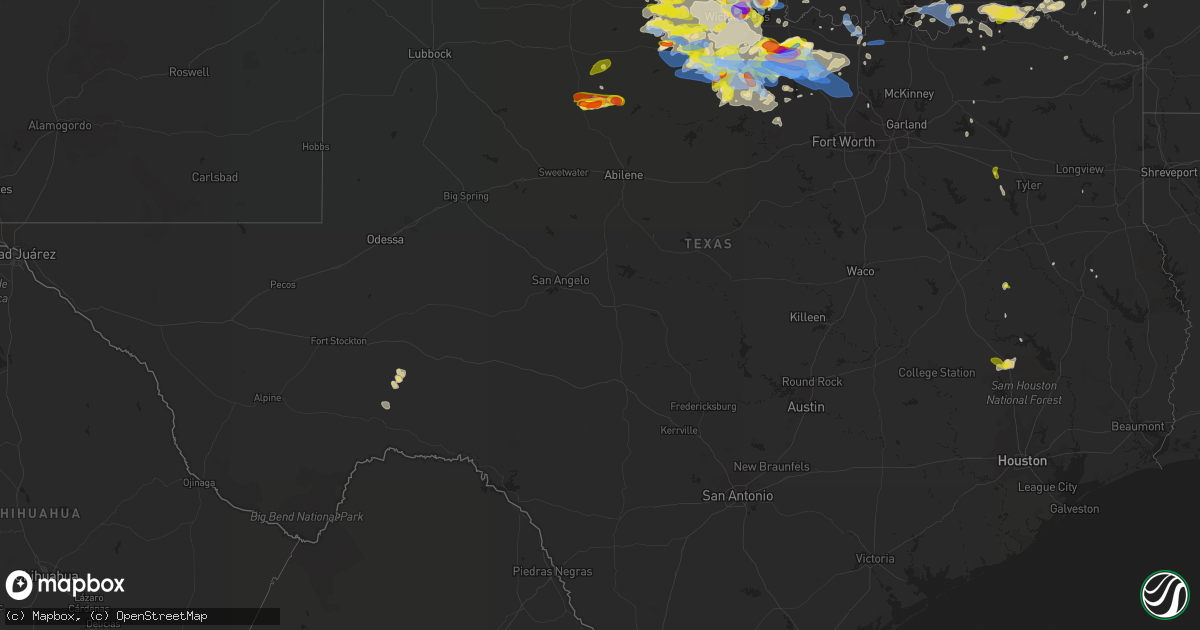
Hail Map in Texas on May 22, 2020
Get this storm
May 22 map
$229
one time, instant access
Download today. No call, no setup
Keep the $229
Bought the map and want the full workflow? Apply the entire $229 to a subscription within 7 days. None of it is wasted.
Every map, not just this one
This buys you this map. Subscription and you get every map we run, in the markets you choose from a few cities to whole states to nationwide. Plus real-time alerts the moment a storm fires.
Contact data
Name, contact info, occupancy, even credit band for addresses in the footprint. You go from where it hit to who to call.
Become the source they trust
Unlimited branding weather history reports on demand. You already have the documented answer ready for the property owner, and you are the one who showed up with it.
Property data and RoofTrace estimates
Pull up any address you have got, its value and the exact code rules for that jurisdiction, straight from One Click Code. Then RoofTrace estimates the squares, pitch, and roof value, priced the way you price.
Storm reports in Texas
Texas
| Date | Description |
|---|---|
| 05/22/20206:50 PM CDT | A local report indicates 2.75 inch wind near BURKBURNETT |
| 05/22/20206:49 PM CDT | A local report indicates 1.75 inch wind near BURKBURNETT |
| 05/22/20206:46 PM CDT | A local report indicates 1.00 inch wind near 1 SE BURKBURNETT |
| 05/22/20206:43 PM CDT | A local report indicates 1.50 inch wind near ASPERMONT |
| 05/22/20206:40 PM CDT | A local report indicates 5.33 inch wind near BURKBURNETT |
| 05/22/20206:30 PM CDT | A local report indicates 1.25 inch wind near 4 W BURKBURNETT |
| 05/22/20206:29 PM CDT | A local report indicates 3.00 inch wind near 7 WNW BURKBURNETT |
| 05/22/20206:11 PM CDT | A local report indicates a tornado near 9 W BURKBURNETT |
| 05/22/20206:56 AM CDT | At 1156 PM CDT, a severe thunderstorm was located near Raymond Gary State Park, or 19 miles east of Hugo, moving east at 30 mph. HAZARD...60 mph wind gusts and quarter size hail. SOURCE...Radar indicated. IMPACT...Hail damage to vehicles is expected. Expect wind damage to roofs, siding, and trees. Locations impacted include... Idabel, Broken Bow, Wright City, Valliant, Millerton, Garvin, Farmers Hill, Rufe, Redland, Holly Creek, Glover, Slim, Oak Hill and Golden. |
| 05/22/20206:49 AM CDT | At 1148 PM CDT, a severe thunderstorm was located 8 miles northeast of Decatur, moving east at 45 mph. HAZARD...60 mph wind gusts and quarter size hail. SOURCE...Radar indicated. IMPACT...Hail damage to vehicles is expected. Expect wind damage to roofs, siding, and trees. Locations impacted include... Plano, Carrollton, Frisco, Denton, Lewisville, Flower Mound, The Colony, Corinth, Highland Village, Lake Dallas, Sanger, Decatur, Lake Lewisville, Little Elm, Krum, Pilot Point, Argyle, Hickory Creek, Double Oak and Shady Shores.This includes the following highways... Interstate 35 between mile markers 468 and 481. Interstate 35W between mile markers 76 and 85. Interstate 35E between mile markers 450 and 466. |
| 05/22/20206:31 AM CDT | At 1130 PM CDT, severe thunderstorms were located along a line extending from 11 miles southeast of Thalia to 9 miles south of Seymour, moving east at 25 mph. Additional storms are located near Lake Kickapoo. HAZARD...60 mph wind gusts and quarter size hail. SOURCE...Radar indicated. IMPACT...Hail damage to vehicles is expected. Expect wind damage to roofs, siding, and trees. Locations impacted include... Wichita Falls, Seymour, Archer City, Iowa Park, Holliday, Scotland, Windthorst, Megargel, Red Springs, Sheppard AFB, Lake Diversion, Dundee, Westover, Bomarton, Lake Kemp, Mabelle, Mankins, Lake Kickapoo, southwestern Lake Arrowhead and Lakeside City. |
| 05/22/20206:27 AM CDT | At 1126 PM CDT, a severe thunderstorm was located 14 miles north of Bryson, or 16 miles northwest of Jacksboro, moving southeast at 30 mph. HAZARD...60 mph wind gusts and quarter size hail. SOURCE...Radar indicated. IMPACT...Hail damage to vehicles is expected. Expect wind damage to roofs, siding, and trees. Locations impacted include... Jacksboro, Olney, Bryson and Newport. |
| 05/22/20206:26 AM CDT | At 1126 PM CDT, a severe thunderstorm was located near Alvord, or near Decatur, moving southeast at 35 mph. HAZARD...65 mph wind gusts and quarter size hail. SOURCE...Radar indicated. IMPACT...Hail damage to vehicles is expected. Expect wind damage to roofs, siding, and trees. Locations impacted include... Decatur, Bridgeport, Briar, Pecan Acres, Alvord, New Fairview, Aurora, Boyd, Chico, Paradise, Cottondale, Forestburg, Sunset, Boonsville, Rhome, Runaway Bay, Newark and Lake Bridgeport. |
| 05/22/20206:12 AM CDT | At 1112 PM CDT, a severe thunderstorm was located near Marietta, moving east at 35 mph. HAZARD...60 mph wind gusts and quarter size hail. SOURCE...Radar indicated. IMPACT...Hail damage to vehicles is expected. Expect wind damage to roofs, siding, and trees. Locations impacted include... Madill, Marietta, Kingston, Thackerville, Lebanon, Willis, Little City, Woodville, Lake Texoma, Burneyville, southeastern Lake Murray and Mcbride. |
| 05/22/20205:55 AM CDT | At 1055 PM CDT, a severe thunderstorm was located 10 miles southwest of Newport, or 10 miles north of Jacksboro, moving southeast at 25 mph. HAZARD...Golf ball size hail and 60 mph wind gusts. SOURCE...Radar indicated. IMPACT...People and animals outdoors will be injured. Expect hail damage to roofs, siding, windows, and vehicles. Expect wind damage to roofs, siding, and trees. Locations impacted include... Jacksboro, Bryson, Boonsville, Newport and Runaway Bay. |
| 05/22/20205:46 AM CDT | At 1046 PM CDT, a severe thunderstorm was located near Holliday, moving east at 25 mph. HAZARD...60 mph wind gusts and quarter size hail. SOURCE...Trained weather spotters. IMPACT...Hail damage to vehicles is expected. Expect wind damage to roofs, siding, and trees. Locations impacted include... Wichita Falls, Holliday, Dean, Jolly, Sheppard AFB, northern Lake Arrowhead, Lakeside City and Pleasant Valley. |
| 05/22/20205:45 AM CDT | At 1045 PM CDT, a severe thunderstorm was located near Archer City, moving east at 20 mph. HAZARD...60 mph wind gusts and quarter size hail. SOURCE...Trained weather spotters. IMPACT...Hail damage to vehicles is expected. Expect wind damage to roofs, siding, and trees. Locations impacted include... Archer City, Scotland, Windthorst, Bellevue, Newport, Lake Arrowhead, Bluegrove, Joy, Vashti and Shannon. |
| 05/22/20205:38 AM CDT | At 1038 PM CDT, a severe thunderstorm was located over eastern Lake Kemp, moving east at 25 mph. HAZARD...Ping pong ball size hail and 60 mph wind gusts. SOURCE...Radar indicated. IMPACT...People and animals outdoors will be injured. Expect hail damage to roofs, siding, windows, and vehicles. Expect wind damage to roofs, siding, and trees. Locations impacted include... Dundee, Lake Kemp, Mankins, Mabelle and Lake Diversion. |
| 05/22/20205:21 AM CDT | At 1021 PM CDT, a severe thunderstorm was located 8 miles west of Newport, or 15 miles north of Jacksboro, moving east at 20 mph. HAZARD...60 mph wind gusts and half dollar size hail. SOURCE...Radar indicated. IMPACT...Hail damage to vehicles is expected. Expect wind damage to roofs, siding, and trees. Locations impacted include... Newport. |
| 05/22/20205:09 AM CDT | At 1009 PM CDT, a severe thunderstorm was located near Alvord, or 13 miles north of Decatur, moving southeast at 30 mph. HAZARD...Golf ball size hail and 65 mph wind gusts. SOURCE...Radar indicated. IMPACT...People and animals outdoors will be injured. Expect hail damage to roofs, siding, windows, and vehicles. Expect wind damage to roofs, siding, and trees. Locations impacted include... Denton, Flower Mound, Sanger, Decatur, Bridgeport, Bowie, Briar, Roanoke, Pecan Acres, Krum, Pilot Point, Argyle, Justin, Aubrey, Northlake, Muenster, Haslet, Alvord, New Fairview and Aurora.This includes the following highways... Interstate 35 between mile markers 468 and 492. Interstate 35W between mile markers 68 and 85. Interstate 35E between mile markers 464 and 466. |
| 05/22/20204:44 AM CDT | At 944 PM CDT, severe thunderstorms were located along a line extending from 3 miles south of Bluegrove to 6 miles south of Windthorst to 4 miles east of Holliday, moving northeast at 30 mph. HAZARD...70 mph wind gusts and ping pong ball size hail. SOURCE...Radar indicated. IMPACT...People and animals outdoors will be injured. Expect hail damage to roofs, siding, windows, and vehicles. Expect considerable tree damage. Wind damage is also likely to mobile homes, roofs, and outbuildings. Locations impacted include... Henrietta, Archer City, Holliday, Scotland, Windthorst, Bellevue, Newport, Lake Arrowhead, Bluegrove, Lakeside City, Shannon, Joy and Vashti. |
| 05/22/20204:40 AM CDT | At 940 PM CDT, a severe thunderstorm was located 7 miles northwest of Lake Kemp, moving northeast at 35 mph. HAZARD...Ping pong ball size hail and 60 mph wind gusts. SOURCE...Radar indicated. IMPACT...People and animals outdoors will be injured. Expect hail damage to roofs, siding, windows, and vehicles. Expect wind damage to roofs, siding, and trees. Locations impacted include... Lake Kemp, Grayback, Harrold and northern Lake Diversion. |
| 05/22/20204:35 AM CDT | At 935 PM CDT, a severe thunderstorm was located near Grady, moving northeast at 25 mph. HAZARD...60 mph wind gusts and quarter size hail. SOURCE...Radar indicated. IMPACT...Hail damage to vehicles is expected. Expect wind damage to roofs, siding, and trees. Locations impacted include... Lone Grove, Healdton, Wilson, Grady, Rubottom, Oscar, Cornish, Courtney and Petersburg. |
| 05/22/20204:27 AM CDT | At 927 PM CDT, a severe thunderstorm was located 12 miles east of Olney, moving east at 40 mph. HAZARD...Ping pong ball size hail and 60 mph wind gusts. SOURCE...Radar indicated. IMPACT...People and animals outdoors will be injured. Expect hail damage to roofs, siding, windows, and vehicles. Expect wind damage to roofs, siding, and trees. Locations impacted include... Jacksboro and Newport. |
| 05/22/20204:22 AM CDT | At 921 PM CDT, a severe thunderstorm was located 6 miles east of Olney, moving northeast at 30 mph. HAZARD...Ping pong ball size hail and 60 mph wind gusts. SOURCE...Radar indicated. IMPACT...People and animals outdoors will be injured. Expect hail damage to roofs, siding, windows, and vehicles. Expect wind damage to roofs, siding, and trees. Locations impacted include... Scotland and Windthorst. |
| 05/22/20204:15 AM CDT | At 915 PM CDT, a severe thunderstorm was located 5 miles northwest of Newport, moving east at 15 mph. This is a very dangerous storm. HAZARD...80 mph wind gusts and golf ball size hail. SOURCE...Radar indicated. IMPACT...Flying debris will be dangerous to those caught without shelter. Mobile homes will be heavily damaged. Expect considerable damage to roofs, windows, and vehicles. Extensive tree damage and power outages are likely. Locations impacted include... Bellevue, Newport, Vashti and Joy. |
| 05/22/20203:48 AM CDT | At 848 PM CDT, a severe thunderstorm was located 11 miles southeast of Thalia, moving northeast at 30 mph. HAZARD...Ping pong ball size hail and 60 mph wind gusts. SOURCE...Radar indicated. IMPACT...People and animals outdoors will be injured. Expect hail damage to roofs, siding, windows, and vehicles. Expect wind damage to roofs, siding, and trees. Locations impacted include... Vernon, Oklaunion, Harrold and Grayback. |
| 05/22/20203:46 AM CDT | At 846 PM CDT, severe thunderstorms were located along a line extending from 8 miles north of Electra to near Devol, moving east at 15 mph. HAZARD...Golf ball size hail and 60 mph wind gusts. SOURCE...Radar indicated. IMPACT...People and animals outdoors will be injured. Expect hail damage to roofs, siding, windows, and vehicles. Expect wind damage to roofs, siding, and trees. Locations impacted include... Burkburnett, Electra, Grandfield, Randlett, Devol, Loveland, Cookietown, Haynesville and Cashion. |
| 05/22/20203:40 AM CDT | At 840 PM CDT, severe thunderstorms were located along a line extending from 3 miles west of Waurika to near Henrietta to near Bluegrove, moving east at 25 mph. HAZARD...Golf ball size hail and 70 mph wind gusts. SOURCE...Radar indicated. IMPACT...People and animals outdoors will be injured. Expect hail damage to roofs, siding, windows, and vehicles. Expect considerable tree damage. Wind damage is also likely to mobile homes, roofs, and outbuildings. Locations impacted include... Henrietta, Waurika, Ringling, Ryan, Terral, Bellevue, Sugden, Grady, Bluegrove, Oscar and Cornish. |
| 05/22/20203:38 AM CDT | At 837 PM CDT, a severe thunderstorm was located over Haskell, moving east at 15 mph. Another severe thunderstorm was located over Sagerton...moving east at 15 mph. HAZARD...Golf ball size hail and 60 mph wind gusts. SOURCE...Radar indicated. IMPACT...People and animals outdoors will be injured. Expect hail damage to roofs, siding, windows, and vehicles. Expect wind damage to roofs, siding, and trees. This severe thunderstorm will be near... Paint Creek around 845 PM CDT. Irby around 930 PM CDT.Other locations impacted by this severe thunderstorm include Us-380 Near The Haskell-Stonewall County Line. |
| 05/22/20203:32 AM CDT | At 832 PM CDT, a severe thunderstorm was located 6 miles northwest of Newport, moving east at 20 mph. HAZARD...Golf ball size hail and 60 mph wind gusts. SOURCE...Radar indicated. IMPACT...People and animals outdoors will be injured. Expect hail damage to roofs, siding, windows, and vehicles. Expect wind damage to roofs, siding, and trees. Locations impacted include... Bellevue, Newport, Vashti, Shannon and Joy. |
| 05/22/20203:30 AM CDT | A local report indicates 2.00 inch wind near 15 S FORT STOCKTON |
| 05/22/20203:21 AM CDT | At 820 PM CDT, a severe thunderstorm was located 5 miles southeast of Aspermont, moving east at 25 mph. HAZARD...60 mph wind gusts and quarter size hail. SOURCE...Radar indicated. IMPACT...Hail damage to vehicles is expected. Expect wind damage to roofs, siding, and trees. Locations impacted include... Old Glory and Us-380 Near The Haskell-Stonewall County Line. |
| 05/22/20203:12 AM CDT | At 811 PM CDT, a severe thunderstorm was located near Bluegrove, moving east at 15 mph. HAZARD...Two inch hail and 60 mph wind gusts. SOURCE...Radar indicated. IMPACT...People and animals outdoors will be injured. Expect hail damage to roofs, siding, windows, and vehicles. Expect wind damage to roofs, siding, and trees. Locations impacted include... Bellevue, Bluegrove and Joy. |
| 05/22/20203:06 AM CDT | At 805 PM CDT, a severe thunderstorm was located 4 miles south of Bellevue, moving east at 15 mph. HAZARD...Golf ball size hail and 60 mph wind gusts. SOURCE...Radar indicated. IMPACT...People and animals outdoors will be injured. Expect hail damage to roofs, siding, windows, and vehicles. Expect wind damage to roofs, siding, and trees. Locations impacted include... Bellevue, Newport and Vashti. |
| 05/22/20202:55 AM CDT | At 755 PM CDT, a severe thunderstorm was located near Petrolia, moving east at 30 mph. This is a very dangerous storm. HAZARD...Baseball size hail and 60 mph wind gusts. SOURCE...Radar indicated. IMPACT...People and animals outdoors will be severely injured. Expect shattered windows, extensive damage to roofs, siding, and vehicles. Locations impacted include... Ryan, Petrolia, Byers, Dean, Terral, Sugden and Oscar. |
| 05/22/20202:51 AM CDT | At 751 PM CDT, a severe thunderstorm was located near Rule, or 10 miles west of Haskell, moving east at 30 mph. HAZARD...Tennis ball size hail and 60 mph wind gusts. SOURCE...Radar indicated. IMPACT...People and animals outdoors will be injured. Expect hail damage to roofs, siding, windows, and vehicles. Expect wind damage to roofs, siding, and trees. This severe thunderstorm will be near... Haskell and Paint Creek around 830 PM CDT.Other locations impacted by this severe thunderstorm include Us-380 Near The Haskell-Stonewall County Line. |
| 05/22/20202:42 AM CDT | At 742 PM CDT, a severe thunderstorm was located 9 miles west of O'brien, moving northeast at 25 mph. HAZARD...Ping pong ball size hail and 60 mph wind gusts. SOURCE...Radar indicated. IMPACT...People and animals outdoors will be injured. Expect hail damage to roofs, siding, windows, and vehicles. Expect wind damage to roofs, siding, and trees. Locations impacted include... Knox City and Benjamin. |
| 05/22/20202:41 AM CDT | At 741 PM CDT, a severe thunderstorm was located 5 miles southwest of Bluegrove, moving northeast at 25 mph. HAZARD...Golf ball size hail and 60 mph wind gusts. SOURCE...Radar indicated. IMPACT...People and animals outdoors will be injured. Expect hail damage to roofs, siding, windows, and vehicles. Expect wind damage to roofs, siding, and trees. Locations impacted include... Henrietta, Bluegrove, eastern Lake Arrowhead and Joy. |
| 05/22/20202:41 AM CDT | At 740 PM CDT, severe thunderstorms were located over Old Glory and rural southeastern King County, moving east at 15 mph. HAZARD...Two inch hail and 60 mph wind gusts. SOURCE...Radar indicated. IMPACT...People and animals outdoors will be injured. Expect hail damage to roofs, siding, windows, and vehicles. Expect wind damage to roofs, siding, and trees. Locations impacted include... Old Glory and Us-380 Near The Haskell-Stonewall County Line. |
| 05/22/20202:33 AM CDT | At 733 PM CDT, a severe thunderstorm was located near Newport, or 13 miles west of Bowie, moving east at 15 mph. HAZARD...Ping pong ball size hail and 60 mph wind gusts. SOURCE...Radar indicated. IMPACT...People and animals outdoors will be injured. Expect hail damage to roofs, siding, windows, and vehicles. Expect wind damage to roofs, siding, and trees. Locations impacted include... Bowie, Sunset and Stoneburg. |
| 05/22/20202:33 AM CDT | At 733 PM CDT, a severe thunderstorm was located 7 miles west of Burkburnett, moving east at 20 mph. HAZARD...Tennis ball size hail and 60 mph wind gusts. SOURCE...Radar indicated. IMPACT...People and animals outdoors will be injured. Expect hail damage to roofs, siding, windows, and vehicles. Expect wind damage to roofs, siding, and trees. Locations impacted include... Wichita Falls, Burkburnett, Iowa Park, Sheppard AFB, Pleasant Valley and Cashion. |
| 05/22/20202:29 AM CDT | At 729 PM CDT, a severe thunderstorm was located over Van, or 12 miles east of Canton, moving north at 40 mph. HAZARD...Quarter size hail. SOURCE...Radar indicated. IMPACT...Damage to vehicles is possible. Locations impacted include... Grand Saline, Van, Fruitvale and Edom. This includes Interstate 20 between mile markers 534 and 542. |
| 05/22/20202:13 AM CDT | At 713 PM CDT, a severe thunderstorm was located 7 miles northeast of Electra, moving northeast at 30 mph. HAZARD...Quarter size hail. SOURCE...Radar indicated. IMPACT...Damage to vehicles is expected. Locations impacted include... Electra. |
| 05/22/20202:06 AM CDT | At 704 PM CDT, a severe thunderstorm was located over Old Glory, or 10 miles east of Aspermont, moving east at 20 mph. HAZARD...Golf ball size hail and 60 mph wind gusts. SOURCE...Radar indicated. IMPACT...People and animals outdoors will be injured. Expect hail damage to roofs, siding, windows, and vehicles. Expect wind damage to roofs, siding, and trees. This severe thunderstorm will be near... Sagerton around 715 PM CDT. Rule around 725 PM CDT. Haskell around 735 PM CDT. Paint Creek around 740 PM CDT.Other locations impacted by this severe thunderstorm include Jud, Us-277 Near The Haskell-Knox County Line and Us-380 Near The Haskell-Stonewall County Line. |
| 05/22/20201:50 AM CDT | At 649 PM CDT, a severe thunderstorm was located near Grandfield, moving east at 10 mph. HAZARD...Golf ball size hail and 60 mph wind gusts. SOURCE...Radar indicated. IMPACT...People and animals outdoors will be injured. Expect hail damage to roofs, siding, windows, and vehicles. Expect wind damage to roofs, siding, and trees. Locations impacted include... Grandfield, Randlett and Devol. |
| 05/22/20201:44 AM CDT | At 643 PM CDT, a severe thunderstorm was located over Aspermont, moving northeast at 15 mph. HAZARD...Two inch hail and 60 mph wind gusts. SOURCE...Trained weather spotters reported up to ping pong ball sized hail in Aspermont. IMPACT...People and animals outdoors will be injured. Expect hail damage to roofs, siding, windows, and vehicles. Expect wind damage to roofs, siding, and trees. Locations impacted include... Aspermont, Peacock, Old Glory, Swenson and Us-380 Near The Haskell- Stonewall County Line. |
| 05/22/20201:03 AM CDT | At 603 PM CDT, a severe thunderstorm was located 7 miles southwest of Grandfield, moving east at 20 mph. This is a very dangerous storm. HAZARD...Baseball size hail and 70 mph wind gusts. SOURCE...Radar indicated. IMPACT...People and animals outdoors will be severely injured. Expect shattered windows, extensive damage to roofs, siding, and vehicles. Locations impacted include... Northern Wichita Falls, Burkburnett, Grandfield, Dean, Randlett, Devol, Sheppard AFB, Taylor, Charlie and Cashion. |
| 05/22/202012:35 AM CDT | Emergency management reports metal roof torn off manufactured home near us377/fm901 near sandusky. |
| 05/22/202012:20 AM CDT | Emergency management reports trees down... Damage to a few rvs... And power lines around us 82 near the oak ridge area eastward. |
| 05/21/202011:58 PM CDT | Reports of quarter size hail and water over the roadway on hwy 281. |
| 05/21/202011:58 PM CDT | At 456 PM CDT, a severe thunderstorm was located near Huntsville, moving west at 20 mph. HAZARD...Quarter size hail. SOURCE...Radar indicated. Spotters have reported pea to dime sized hail from this storm in Huntsvile. IMPACT...Damage to vehicles is expected. Locations impacted include... Huntsville, Huntsville State Park and Crabbs Prairie. |
| 05/21/202011:36 PM CDT | Emergency management reports metal roofing pulled off an apartment complex in whitesboro. |
| 05/21/202011:25 PM CDT | At 425 PM CDT, a severe thunderstorm was located over Huntsville State Park, or near Huntsville, moving southwest at 20 mph. HAZARD...60 mph wind gusts and quarter size hail. SOURCE...Radar indicated. IMPACT...Hail damage to vehicles is expected. Expect wind damage to roofs, siding, and trees. Locations impacted include... Huntsville, New Waverly and Huntsville State Park. |
| 05/21/202011:22 PM CDT | Reports of damage to power poles and trees in whitesboro. |
| 05/21/202011:20 PM CDT | A local report indicates 0 MPH wind near 3 N BRIDGEPORT |
| 05/21/202011:20 PM CDT | Results from nws storm survey indicated that tree and light structural damage across a 12 mile path in eastern cooke and extreme western grayson counties were consisten |
| 05/21/202011:18 PM CDT | A local report indicates 1.00 inch wind near 4 NNW MANKINS |
| 05/21/202011:15 PM CDT | Reports of 8 inch diameter tree limbs down 5 miles east of forestburg. |
| 05/21/202010:51 PM CDT | Quarter size hail reported east of shannon by a trained spotter. |
| 05/21/202010:43 PM CDT | A local report indicates 1.00 inch wind near HOLLIDAY |
| 05/21/202010:40 PM CDT | A local report indicates 1.00 inch wind near ARCHER CITY |
| 05/21/20209:41 PM CDT | Trained spotters report tree and building damage with power out throughout the area. |
| 05/21/20209:34 PM CDT | Golf ball hail reported near the intersection between jack... Clay... And wise counties. |
| 05/21/20209:31 PM CDT | Trained spotter reporting tree limbs and other debris in the road. |
| 05/21/20209:18 PM CDT | Building damage reported near 81 and hwy 287. |
| 05/21/20209:18 PM CDT | Trained spotter reported 2 inch hail northwest of bowie. |
| 05/21/20209:10 PM CDT | An nws storm survey team determined that a brief tornado occurred near the city of bowie in montague county. The intensity of damage associated with this tornado sugges |
| 05/21/20209:03 PM CDT | Spotter estimated 60 mph wind gusts and tree limbs down southwest of bowie. |
| 05/21/20208:48 PM CDT | A local report indicates 1.50 inch wind near 2 SE BELLEVUE |
| 05/21/20208:38 PM CDT | A local report indicates 1.75 inch wind near 1 SE BELLEVUE |
| 05/21/20208:37 PM CDT | 2 inch hail reported around pelham street and lee street in bowie. |
| 05/21/20208:37 PM CDT | A local report indicates 1.00 inch wind near BELLEVUE |
| 05/21/20208:24 PM CDT | A local report indicates 1.00 inch wind near 1 ENE JOLLY |
| 05/21/20208:21 PM CDT | A local report indicates 1.00 inch wind near 3 S DEAN |
| 05/21/20208:20 PM CDT | Golf ball size hail at bullard rd near hwy 287. |
| 05/21/20208:09 PM CDT | A local report indicates 2.50 inch wind near 2 S BELLEVUE |
| 05/21/20208:08 PM CDT | A local report indicates 1.25 inch wind near 2 SE BURKBURNETT |
| 05/21/20208:05 PM CDT | A local report indicates 1.75 inch wind near 1 SSE WICHITA FALLS |
| 05/21/20208:05 PM CDT | East side of wichita falls |
| 05/21/20208:02 PM CDT | A local report indicates 2.75 inch wind near PETROLIA |
| 05/21/20208:00 PM CDT | A local report indicates 1.75 inch wind near 1 W WICHITA FALLS |
| 05/21/20207:59 PM CDT | Iowa park rd just north of i-44 |
| 05/21/20207:57 PM CDT | Sheppard afb |
| 05/21/20207:53 PM CDT | A local report indicates 1.75 inch wind near WICHITA FALLS |
| 05/21/20207:52 PM CDT | Sheppard afb asos |
| 05/21/20207:52 PM CDT | I-44/riley rd. |
| 05/21/20207:35 PM CDT | A local report indicates 1.00 inch wind near VAN |
| 05/21/20207:28 PM CDT | A local report indicates 2.75 inch wind near 5 WSW CHARLIE |
| 05/21/20207:27 PM CDT | A local report indicates a tornado near 6 NNW DEAN |
| 05/21/20207:23 PM CDT | A local report indicates 60 MPH wind near 6 N DEAN |
| 05/21/20207:23 PM CDT | A local report indicates a tornado near 4 NE SHANNON |
| 05/21/20207:17 PM CDT | Rfd wind... Powerlines downed |
| 05/21/20207:05 PM CDT | A local report indicates 1.50 inch wind near CHARLIE |
| 05/21/20207:03 PM CDT | A local report indicates 1.75 inch wind near 2 SE BURKBURNETT |
| 05/21/20207:00 PM CDT | Estimated marble to ping pong ball size hail |
All States Impacted by Hail Map on May 22, 2020
Cities Impacted by Hail Map on May 22, 2020
- Sherwood, AR
- Jacksonville, AR
- Richton, MS
- Waynesboro, MS
- Ovett, MS
- Sarasota, FL
- Wister, OK
- Heavener, OK
- Alabaster, AL
- Vernon, TX
- Davidson, OK
- Claxton, GA
- Goodwater, AL
- Weogufka, AL
- Sylacauga, AL
- White Cloud, KS
- Highland, KS
- Laurel, MS
- Iowa Park, TX
- Sheppard Afb, TX
- Burkburnett, TX
- Wichita Falls, TX
- Wagoner, OK
- Chouteau, OK
- Parthenon, AR
- Ponca, AR
- Broken Bow, OK
- Seymour, TX
- Blackville, SC
- Allendale, SC
- Ulmer, SC
- Olar, SC
- Fort Towson, OK
- Valliant, OK
- Stigler, OK
- Red Oak, OK
- Alvord, TX
- Sunset, TX
- Forestburg, TX
- Talladega, AL
- Alpine, AL
- Gadsden, SC
- Eastover, SC
- Louisville, AL
- Griffithville, AR
- Oden, AR
- Mount Ida, AR
- Norman, AR
- Huntsville, TX
- Calhoun Falls, SC
- Abbeville, SC
- Iva, SC
- Richland, GA
- Preston, GA
- Des Arc, AR
- Addison, AL
- Bamberg, SC
- Hugo, OK
- Marion, AL
- Bowie, TX
- Bellevue, TX
- Harrold, TX
- Hollister, OK
- Frederick, OK
- Randlett, OK
- Loveland, OK
- Electra, TX
- Devol, OK
- Grandfield, OK
- Oklaunion, TX
- Huntington, AR
- Hackett, AR
- Greenwood, AR
- Jesup, GA
- Odum, GA
- Donalsonville, GA
- Waldron, AR
- Soso, MS
- Taylorsville, MS
- Maysville, GA
- Colbert, GA
- Nicholson, GA
- Commerce, GA
- Pendergrass, GA
- Hull, GA
- Danielsville, GA
- Jefferson, GA
- Huntsville, AR
- Goodspring, TN
- Prospect, TN
- Nocona, TX
- Saint Jo, TX
- Shelby, AL
- Columbiana, AL
- Montevallo, AL
- Randolph, AL
- Brierfield, AL
- Jemison, AL
- Calera, AL
- West Blocton, AL
- Winslow, AR
- West Fork, AR
- Prairie Grove, AR
- Gilbertown, AL
- Melvin, AL
- Whigham, GA
- Gainesville, TX
- Valley View, TX
- Lovelady, TX
- Vilonia, AR
- Mount Vernon, AR
- El Paso, AR
- Pineville, SC
- Eutawville, SC
- Cross, SC
- Rule, TX
- Aspermont, TX
- Old Glory, TX
- Haskell, TX
- Santee, SC
- Tifton, GA
- Sumner, GA
- Omega, GA
- Ty Ty, GA
- Arkadelphia, AR
- Comer, GA
- Carlton, GA
- Elberton, GA
- Bowman, GA
- Dewy Rose, GA
- Jayess, MS
- Scooba, MS
- Durant, OK
- Telephone, TX
- Bennington, OK
- Childersburg, AL
- Eutaw, AL
- Louin, MS
- Glenwood, AL
- Fort Smith, AR
- Quincy, FL
- Chattahoochee, FL
- Cumming, GA
- Canton, GA
- Alpharetta, GA
- Georgetown, GA
- Greenville, GA
- Yates Center, KS
- Wilson, OK
- Aiken, SC
- Ridge Spring, SC
- Estill, SC
- Monetta, SC
- Batesburg, SC
- Bokchito, OK
- Sumiton, AL
- Cordova, AL
- Dora, AL
- Anniston, AL
- Pine Apple, AL
- Howe, OK
- Poteau, OK
- Hodgen, OK
- Columbia, SC
- Blythewood, SC
- Elgin, SC
- Cape Coral, FL
- Quinton, OK
- Cuthbert, GA
- Locust Grove, OK
- Pryor, OK
- Conway, AR
- De Kalb, MS
- Shuqualak, MS
- Preston, MS
- Clopton, AL
- Ryan, OK
- Henrietta, TX
- Byers, TX
- Petrolia, TX
- Mena, AR
- Grady, AL
- Ramer, AL
- Jacksboro, TX
- Luray, SC
- Birmingham, AL
- Chesterfield, SC
- Ball Ground, GA
- Burneyville, OK
- Overbrook, OK
- Surrency, GA
- Chillicothe, TX
- Odell, TX
- Cullman, AL
- Falkville, AL
- Vinemont, AL
- Union Springs, AL
- Midway, AL
- Elkmont, AL
- Okolona, AR
- Harpersville, AL
- Windthorst, TX
- Eufaula, AL
- Clayton, AL
- Abbeville, AL
- Fort Gaines, GA
- Caddo Gap, AR
- Opelika, AL
- Cusseta, AL
- Valley, AL
- Sylvania, GA
- Pembroke, GA
- Booneville, AR
- Buford, GA
- Suwanee, GA
- Havana, AR
- Belleville, AR
- Mansfield, AR
- Fairfax, SC
- Danville, AR
- Cotton Plant, AR
- Iuka, MS
- Haworth, OK
- Gainesville, GA
- Talmo, GA
- Rosston, TX
- Montague, TX
- Decatur, TX
- Bay Springs, MS
- Stringer, MS
- Pearl River, LA
- Bryson, TX
- Monticello, MS
- Sontag, MS
- Newhebron, MS
- Caddo, OK
- Girard, GA
- Greenville, AL
- North Fort Myers, FL
- Horton, AL
- Boaz, AL
- Altus, OK
- Glenwood, AR
- Amity, AR
- Minor Hill, TN
- Perrin, TX
- Springdale, AR
- Hindsville, AR
- Rockford, AL
- Kellyton, AL
- Brooklet, GA
- Talihina, OK
- Ringgold, TX
- Elloree, SC
- Millry, AL
- Silas, AL
- Ellisville, MS
- Holliday, TX
- Saluda, SC
- Bottineau, ND
- Hatfield, AR
- Hartselle, AL
- Axson, GA
- Beebe, AR
- Roosevelt, OK
- Mountain Park, OK
- Snyder, OK
- Pottsboro, TX
- Lavaca, AR
- Ridgeland, SC
- Coosawhatchie, SC
- Yemassee, SC
- Lester, AL
- Brookwood, AL
- Glennville, GA
- Mccomb, MS
- Summit, MS
- Porterville, MS
- Ardmore, OK
- Springer, OK
- Dardanelle, AR
- Plainview, AR
- Ola, AR
- Dorchester, SC
- Harleyville, SC
- Nacogdoches, TX
- Dryden, TX
- Medicine Park, OK
- Petty, TX
- Roxton, TX
- Pittsview, AL
- Oregon, MO
- Forest Home, AL
- Georgiana, AL
- Carlisle, AR
- Lonoke, AR
- Middleburg, FL
- Bigelow, AR
- Mayflower, AR
- Varnville, SC
- Pineland, SC
- Early Branch, SC
- Reevesville, SC
- Lone Oak, TX
- Point, TX
- Troy, SC
- Bradley, SC
- Casa, AR
- Greenwood, SC
- Chappells, SC
- Silverstreet, SC
- Ninety Six, SC
- Cross Hill, SC
- Evergreen, AL
- Leesville, SC
- Newberry, SC
- Lexington, SC
- Chapin, SC
- Gilbert, SC
- Prosperity, SC
- Apache, OK
- Fort Cobb, OK
- Wyandotte, OK
- Lone Grove, OK
- Olney, TX
- Grant, OK
- Lincoln, AL
- Eastaboga, AL
- Boswell, OK
- Arthur City, TX
- Paris, TX
- Blossom, TX
- Detroit, TX
- Sawyer, OK
- Keota, OK
- Bokoshe, OK
- Spiro, OK
- Lugoff, SC
- York, AL
- Screven, GA
- Falls City, NE
- Hiawatha, KS
- Hurtsboro, AL
- Iron City, GA
- Garvin, OK
- Hartford, AR
- Ben Wheeler, TX
- Camden, AL
- Saint Matthews, SC
- Banks, AL
- Sterrett, AL
- Vincent, AL
- Jacksonville, GA
- Ocilla, GA
- Norman Park, GA
- Hartsville, SC
- Orangeburg, SC
- Atoka, OK
- Lane, OK
- Riverside, AL
- Pell City, AL
- Sheffield, TX
- Sabetha, KS
- Morrill, KS
- Muenster, TX
- Ariton, AL
- Skipperville, AL
- Weatherford, TX
- Whitt, TX
- Rosendale, MO
- King City, MO
- Union Star, MO
- Guilford, MO
- Rea, MO
- Helena, MO
- Savannah, MO
- Broken Arrow, OK
- Bridgeport, TX
- Fitzpatrick, AL
- Mathews, AL
- Fort Myers, FL
- Sims, AR
- Cache, OK
- Indiahoma, OK
- Epes, AL
- Livingston, AL
- Emelle, AL
- Troy, AL
- North, SC
- Swansea, SC
- Augusta, AR
- Ellabell, GA
- Little Rock, AR
- Blackshear, GA
- Waycross, GA
- Hatchechubbee, AL
- Clanton, AL
- McCrory, AR
- Wynne, AR
- Hickory Ridge, AR
- Kinta, OK
- Mccurtain, OK
- Loving, TX
- Chico, TX
- Jermyn, TX
- Newville, AL
- Elmer, OK
- Graham, TX
- Colquitt, GA
- Marbury, AL
- Verbena, AL
- Bogue Chitto, MS
- Ruth, MS
- Flowery Branch, GA
- Archer City, TX
- Scotland, TX
- Neeses, SC
- Honey Grove, TX
- Sumner, TX
- Fosters, AL
- Moundville, AL
- Flower Mound, TX
- Lewisville, TX
- Hampton, SC
- Ocoee, FL
- Apopka, FL
- Bokeelia, FL
- Davis, OK
- Sulphur, OK
- Irmo, SC
- Keysville, GA
- Pocola, OK
- Fort Davis, AL
- Hardaway, AL
- Martin, SC
- Equality, AL
- Headland, AL
- Paradise, TX
- Grapeland, TX
- Crockett, TX
- Jakin, GA
- Protem, MO
- Florence, SC
- Newington, GA
- Leesburg, GA
- Albany, GA
- Lagrange, GA
- Rembert, SC
- Brinkley, AR
- Knoxville, AL
- Selma, AL
- Tyler, AL
- Thomasville, AL
- Leoma, TN
- Lawrenceburg, TN
- Peterman, AL
- Beatrice, AL
- Little Mountain, SC
- Sumter, SC
- Cameron, OK
- Harrisburg, AR
- Bagwell, TX
- Powderly, TX
- Oakwood, GA
- Alexander City, AL
- Warwick, GA
- Ashburn, GA
- Tipton, OK
- Delta, AL
- Oxford, AL
- Munford, AL
- Heflin, AL
- Tuscaloosa, AL
- Walters, OK
- Danville, AL
- Marietta, OK
- Thackerville, OK
- Nicholls, GA
- Fillmore, MO
- McRae, AR
- Ivanhoe, NC
- Blountsville, AL
- Boligee, AL
- Keota, IA
- Washington, IA
- Mcalester, OK
- Wilburton, OK
- Lapine, AL
- Johnston, SC
- Anderson, MO
- Henderson, TX
- Barnwell, SC
- Wynnewood, OK
- Cheraw, SC
- Denmark, SC
- Sallisaw, OK
- Headrick, OK
- Inola, OK
- Carnegie, OK
- Seneca, MO
- Goodman, MO
- Jasper, GA
- Baxley, GA
- Boles, AR
- Magnolia, MS
- Forest City, MO
- Craig, MO
- Ludowici, GA
- Jacksonville, FL
- Pencil Bluff, AR
- Bogata, TX
- Register, GA
- Harvey, AR
- Newton, MS
- Decatur, MS
- Cherry Valley, AR
- Dothan, AL
- Atkinson, NC
- Aliceville, AL
- Dry Branch, GA
- Macon, GA
- Ridgeway, SC
- McCormick, SC
- Mount Carmel, SC
- Annona, TX
- Columbia, AL
- Damascus, GA
- Norway, SC
- McKenzie, AL
- Heidelberg, MS
- Muldrow, OK
- Butler, AL
- Neosho, MO
- Jay, OK
- Grove, OK
- Rogers, AR
- Athens, AL
- Brundidge, AL
- Biscoe, AR
- Stella, MO
- Nashville, AR
- Naples, FL
- Fairview, KS
- Gay, GA
- Pine Mountain, GA
- Bascom, FL
- Trussville, AL
- Porum, OK
- Checotah, OK
- Wheatley, AR
- Watson, OK
- Houston, AR
- Montgomery, AL
- Highland Home, AL
- Luverne, AL
- Bessemer, AL
- Fairfield, AL
- Dolomite, AL
- Ozark, AL
- Cades, SC
- Seminary, MS
- Ashland, AL
- Kingston, OK
- Mead, OK
- Calera, OK
- Safford, AL
- Orrville, AL
- Wagarville, AL
- Chandler, TX
- Brownsboro, TX
- Doerun, GA
- Bluffton, AR
- Parks, AR
- Rover, AR
- Midland, AR
- Shady Point, OK
- Briggsville, AR
- Gravelly, AR
- Colbert, OK
- Meridian, MS
- Alto, TX
- Collinsville, TX
- Omaha, GA
- Lumpkin, GA
- Cusseta, GA
- Buena Vista, GA
- De Queen, AR
- Campbell, TX
- Oskaloosa, IA
- Mineral Wells, TX
- Murfreesboro, AR
- Mound City, MO
- Maitland, MO
- Lenox, TN
- Dyersburg, TN
- Bowdon, GA
- Newcastle, TX
- Shellman, GA
- Johnson, NE
- Searcy, AR
- Cabot, AR
- Little Rock Air Force Base, AR
- North Little Rock, AR
- Brent, AL
- Zellwood, FL
- Marion Junction, AL
- Uniontown, AL
- Sarcoxie, MO
- Diamond, MO
- Granby, MO
- Canehill, AR
- Dawsonville, GA
- Charleston, AR
- Ringling, OK
- Pettigrew, AR
- Letohatchee, AL
- Poulan, GA
- Lawton, OK
- Vance, SC
- Wills Point, TX
- Mershon, GA
- Dunseith, ND
- Shubuta, MS
- Lawrence, MS
- Goshen, AL
- Pelham, AL
- Statesboro, GA
- Cayce, SC
- West Columbia, SC
- Hopkins, SC
- Franklin, GA
- Macon, MS
- Athens, GA
- Moody, AL
- Leeds, AL
- Petal, MS
- Trinity, TX
- Guntersville, AL
- Joplin, MO
- Dierks, AR
- Andalusia, AL
- Ward, AR
- Everton, AR
- Rulo, NE
- Duncanville, AL
- Hobart, OK
- Branchville, SC
- Era, TX
- Ehrhardt, SC
- Crowell, TX
- Sanger, TX
- Eldorado, OK
- Rutledge, AL
- Tuskegee, AL
- Marked Tree, AR
- Trumann, AR
- Trenton, SC
- Coweta, OK
- Lauderdale, MS
- Patrick, SC
- McBee, SC
- Leslie, GA
- Americus, GA
- Eufaula, OK
- Lowndesville, SC
- Smithville, OK
- Dawson, GA
- Weston, GA
- Parrott, GA
- Woodstock, GA
- Lockesburg, AR
- Stark City, MO
- Pierce City, MO
- Washburn, MO
- Edgefield, SC
- Witter, AR
- Combs, AR
- Saint Paul, AR
- Brookston, TX
- Holly Pond, AL
- Arab, AL
- Troy, KS
- Amazonia, MO
- Winter Garden, FL
- Garnett, SC
- Collins, MS
- Morris, GA
- Coleman, GA
- Fisher, AR
- Whitefield, OK
- Canadian, OK
- Elba, AL
- Scott, AR
- Jack, AL
- Loretto, TN
- Pinson, AL
- Springville, AL
- Arlington, TN
- Millington, TN
- Memphis, TN
- Earle, AR
- Turrell, AR
- Crawfordsville, AR
- West Memphis, AR
- Parkin, AR
- Proctor, AR
- Marion, AR
- Forrest City, AR
- Colt, AR
- Tyronza, AR
- Gans, OK
- Salina, OK
- Ivanhoe, TX
- Wathena, KS
- Salem, NE
- Pinola, MS
- Homer, GA
- Royston, GA
- Carnesville, GA
- Gillsville, GA
- Hartwell, GA
- Starr, SC
- Anderson, SC
- Hogansville, GA
- Byromville, GA
- Elko, GA
- Hawkinsville, GA
- Unadilla, GA
- Vienna, GA
- Pinehurst, GA
- Perry, GA
- Jeffersonville, GA
- Cochran, GA
- Danville, GA
- Irwinton, GA
- Gainesville, AL
- Brunson, SC
- Cameron, SC
- Summerton, SC
- Dalzell, SC
- Shaw Afb, SC
- Bowman, SC
- Rowesville, SC
- Holly Hill, SC
- Van, TX
- O'Brien, TX
- Paducah, TX
- Knox City, TX
- Temple, OK
- Saint Petersburg, FL
- Orlando, FL
- Denton, TX
- Ponder, TX
- Rhome, TX
- Krum, TX
- Justin, TX
- Whitesboro, TX
- Throckmorton, TX
- Teachey, NC
- Clinton, NC
- Garland, NC
- Beulaville, NC
- Wallace, NC
- Magnolia, NC
- Richlands, NC
- Chinquapin, NC
- Rose Hill, NC
- Aberdeen, NC
- Rockingham, NC
- Hoffman, NC
- Raeford, NC
- Marston, NC
- Wagram, NC
- Hamlet, NC
- Pinebluff, NC
- Southern Pines, NC
- Vass, NC
- Spartanburg, SC
- Pacolet, SC
- Gaffney, SC
- Cowpens, SC
- Gastonia, NC
- Blacksburg, SC
- Clover, SC
- Kings Mountain, NC
- Smyrna, SC
- Hickory Grove, SC
- York, SC
- Sharon, SC
- Buffalo, SC
- Union, SC
- Jonesville, SC
- Pauline, SC
- Grover, NC
- Polkton, NC
- Oakboro, NC
- Mount Gilead, NC
- Norwood, NC


