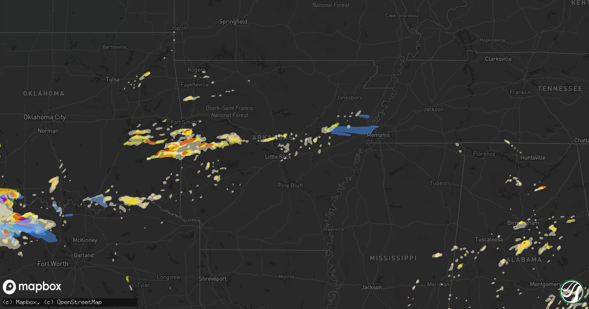
Hail Map in Arkansas on May 22, 2020
Get this storm
May 22 map
$229
one time, instant access
Download today. No call, no setup
Keep the $229
Bought the map and want the full workflow? Apply the entire $229 to a subscription within 7 days. None of it is wasted.
Every map, not just this one
This buys you this map. Subscription and you get every map we run, in the markets you choose from a few cities to whole states to nationwide. Plus real-time alerts the moment a storm fires.
Contact data
Name, contact info, occupancy, even credit band for addresses in the footprint. You go from where it hit to who to call.
Become the source they trust
Unlimited branding weather history reports on demand. You already have the documented answer ready for the property owner, and you are the one who showed up with it.
Property data and RoofTrace estimates
Pull up any address you have got, its value and the exact code rules for that jurisdiction, straight from One Click Code. Then RoofTrace estimates the squares, pitch, and roof value, priced the way you price.
Storm reports in Arkansas
Arkansas
| Date | Description |
|---|---|
| 05/22/20204:25 PM CDT | Grain bins damaged... Roof taken off barn near dacus rd. |
| 05/22/20204:10 PM CDT | Large trees fell on trailer and car |
| 05/22/20204:10 PM CDT | Grain bin damaged along hwy 64. |
| 05/22/20203:55 PM CDT | Camper flipped over turned near mile marker 12 on i55. |
| 05/22/20203:45 PM CDT | Measured near highway 64 cr 401. |
| 05/22/20203:45 PM CDT | Public reported trees down and other wind damage in wynne. |
| 05/22/20203:35 PM CDT | Attached carport destroyed along highway 193s. |
| 05/22/20203:24 PM CDT | Trees down along hyw 49 near fair oaks. |
| 05/22/20203:20 PM CDT | Thunderstorm wind damage was observed across portions of eastern woodruff county as numerous trees were blown down along with several powerpoles. A few homes received m |
| 05/22/20203:03 PM CDT | Quarter size hail was noted about four miles northeast of des arc. |
| 05/22/20202:30 PM CDT | Trees down along hyw 49 near fair oaks. |
| 05/22/202011:30 AM CDT | A few trees were blown down in the area with power outages in this location as well. |
| 05/22/20209:58 AM CDT | Tree damage reported and confirmed via picture on social media. Time is estimated from radar. |
| 05/22/20207:33 AM CDT | At 1233 AM CDT, a severe thunderstorm was located over Linwood, or 14 miles east of Pine Bluff, moving northeast at 15 mph. HAZARD...60 mph wind gusts and quarter size hail. SOURCE...Radar indicated. IMPACT...Hail damage to vehicles is expected. Expect wind damage to roofs, siding, and trees. Locations impacted include... Linwood... Richardson... Cottondale... Woodville... Madding... Cornerstone... Tamo... Moscow... Sarassa... Glenlake... Bayou Meteo State Game Area... |
| 05/22/20207:16 AM CDT | At 1216 AM CDT, a severe thunderstorm was located near White Hall, or 10 miles west of Pine Bluff, moving northeast at 20 mph. HAZARD...60 mph wind gusts and quarter size hail. SOURCE...Radar indicated. IMPACT...Hail damage to vehicles is expected. Expect wind damage to roofs, siding, and trees. Locations impacted include... Pine Bluff... White Hall... Warbritton... Pine Bluff Arsenal... Sulphur Springs... Watson Chapel... Samples... Clear Lake... Hardin... Dexter... Prague... This includes Interstate 530 between mile markers 26 and 40. |
| 05/22/20207:06 AM CDT | At 1205 PM CDT, severe thunderstorms were located along a line extending from near Duff to Dabney, moving east at 40 mph. HAZARD...60 mph wind gusts and penny size hail. SOURCE...Radar indicated. IMPACT...Expect damage to roofs, siding, and trees. Locations impacted include... Heber Springs... Mountain View... Clinton... Fairfield Bay... Melbourne... Marshall... Calico Rock... Greers Ferry... Oxford... Norfork... Salesville... Shirley... Concord... Pineville... Higden... Lone Star... Herron... Maumee... Cartney... Elberta... |
| 05/22/20206:56 AM CDT | At 1155 PM CDT, a severe thunderstorm was located over Petit Jean River WMA, or near Danville, moving east at 25 mph. HAZARD...60 mph wind gusts and quarter size hail. SOURCE...Radar indicated. IMPACT...Hail damage to vehicles is expected. Expect wind damage to roofs, siding, and trees. Locations impacted include... Danville... Ola... Adona... Carden Bottoms... Petit Jean State Park... Plainview in Yell County... Petit Jean River WMA... Galla Creek WMA... Mosley... Casa... Aplin... Birta... Ada... Nimrod... Ranger... Holla Bend... Kingston... Cherry Hill in Perry County... Carter Cove Park... Lakeview in Yell County... |
| 05/22/20206:48 AM CDT | At 1148 PM CDT, severe thunderstorms were located along a line extending from near Cardiff to near Stonehouse Recreation Area, moving southeast at 25 mph. HAZARD...60 mph wind gusts and quarter size hail. SOURCE...Radar indicated. IMPACT...Hail damage to vehicles is expected. Expect wind damage to roofs, siding, and trees. Locations impacted include... Plainview in Yell County... Gravelly... Fourche Valley... Muddy Creek WMA... Union Hill... Wing... Chula... Macedonia in Yell County... Waltreak... Bluffton... Rover... Nola... Harvey... Onyx... Fourche Mountain Recreation Are... Briggsville... Blue Ball... Sunlight Bay Park... |
| 05/22/20206:41 AM CDT | At 1140 PM CDT, a severe thunderstorm was located 7 miles west of Beauchamp, or 17 miles northwest of Mena, moving east at 25 mph. HAZARD...60 mph wind gusts and half dollar size hail. SOURCE...Radar indicated. IMPACT...Hail damage to vehicles is expected. Expect wind damage to roofs, siding, and trees. Locations impacted include... Waldron... Beauchamp... Y City... Boles... Parks... Needmore... |
| 05/22/20206:28 AM CDT | At 1128 PM CDT, a severe thunderstorm was located near Danville, moving east at 20 mph. HAZARD...60 mph wind gusts and quarter size hail. SOURCE...Radar indicated. IMPACT...Hail damage to vehicles is expected. Expect wind damage to roofs, siding, and trees. Locations impacted include... Danville... Dardanelle... Ola... Plainview in Yell County... Petit Jean River WMA... Mt Nebo State Park... Mosley... Lake Dardanelle State Park... Belleville... Havana... Corinth... Ranger... Macedonia in Yell County... Mt George... Kingston... Chickalah... Centerville... Spring Lake Campground... |
| 05/22/20206:20 AM CDT | At 1119 PM CDT, a severe thunderstorm was located over Waldron, moving northeast at 25 mph. HAZARD...60 mph wind gusts and quarter size hail. SOURCE...Radar indicated. IMPACT...Hail damage to vehicles is expected. Expect wind damage to roofs, siding, and trees. Locations impacted include... Waldron... Cardiff... Nola... Needmore... Winfield... Olio... |
| 05/22/20206:11 AM CDT | At 1110 PM CDT, a severe thunderstorm was located near Petit Jean River WMA, or near Danville, moving northeast at 20 mph. HAZARD...60 mph wind gusts and quarter size hail. SOURCE...Radar indicated. IMPACT...Hail damage to vehicles is expected. Expect wind damage to roofs, siding, and trees. Locations impacted include... Russellville... Dardanelle... Ola... Mt Nebo State Park... Lake Dardanelle State Park... Mosley... Petit Jean River WMA... Lake Dardanelle... Ranger... Mt George... Chickalah... Centerville... |
| 05/22/20205:58 AM CDT | At 1057 PM CDT, a severe thunderstorm was located near Magazine, or 7 miles southeast of Booneville, moving east at 25 mph. HAZARD...60 mph wind gusts and quarter size hail. SOURCE...Radar indicated. IMPACT...Hail damage to vehicles is expected. Expect wind damage to roofs, siding, and trees. Locations impacted include... Booneville... Danville... Magazine... Blue Mountain... Stonehouse Recreation Area... Mount Magazine... Fourche Valley... Belleville... Havana... Corinth... Wing... Macedonia in Yell County... Waveland... Waltreak... Rover... Sugar Grove... Briggsville... Grayson... Blue Ball... Spring Lake Campground... |
| 05/22/20205:57 AM CDT | At 1057 PM CDT, a severe thunderstorm was located 7 miles southeast of Heavener Runestone State Park, or 17 miles south of Poteau, moving east at 40 mph. HAZARD...60 mph wind gusts and quarter size hail. SOURCE...Radar indicated. IMPACT...Hail damage to vehicles is expected. Expect wind damage to roofs, siding, and trees. Locations impacted include... Waldron... Mansfield... Beauchamp... Echo... Oliver... Morgan Springs... Bates... Black Fork... Cauthron... Winfield... Hon... Lucas... Liberty... Needmore... Boles... Parks... Elm Park... |
| 05/22/20205:12 AM CDT | At 1012 PM CDT, a severe thunderstorm was located near Echo, or 10 miles north of Waldron, moving east at 15 mph. HAZARD...60 mph wind gusts and quarter size hail. SOURCE...Radar indicated. IMPACT...Hail damage to vehicles is expected. Expect wind damage to roofs, siding, and trees. Locations impacted include... Booneville... Mansfield... Magazine... Echo... Barber... Lucas... Sugar Grove... Carolan... Grayson... Glendale in Logan County... Ione... Elm Park... Hon... |
| 05/22/20204:27 AM CDT | At 927 PM CDT, a severe thunderstorm was located over Danville, moving east at 15 mph. HAZARD...60 mph wind gusts and quarter size hail. SOURCE...Radar indicated. IMPACT...Hail damage to vehicles is expected. Expect wind damage to roofs, siding, and trees. Locations impacted include... Danville... Ola... Plainview in Yell County... Petit Jean River WMA... Belleville... Havana... Casa... Corinth... Birta... Carter Cove Park... Nimrod... Ranger... Macedonia in Yell County... Mt George... Kingston... Centerville... Rover... Fourche Junction... Sunlight Bay Park... Garden Point Recreation Area... |
| 05/22/20204:25 AM CDT | At 924 PM CDT, two severe thunderstorms were located near Mansfield, or 13 miles northwest of Waldron, moving east at 25 mph, and 1 mile east of Witcherville moving east at 25 mph. HAZARD...Ping pong ball size hail and 60 mph wind gusts. SOURCE...Radar indicated. IMPACT...People and animals outdoors will be injured. Expect hail damage to roofs, siding, windows, and vehicles. Expect wind damage to roofs, siding, and trees. Locations impacted include... Booneville... Waldron... Mansfield... Magazine... Ratcliff... Cardiff... Echo... Oliver... Morgan Springs... Caulksville... Barber... Cauthron... Hon... Lucas... Chismville... Liberty... Carolan... Grayson... Glendale in Logan County... Ione... |
| 05/22/20203:38 AM CDT | At 838 PM CDT, a severe thunderstorm was located near Fourche Valley, or 13 miles southwest of Danville, moving east at 25 mph. HAZARD...Golf ball size hail and 60 mph wind gusts. SOURCE...Radar indicated. IMPACT...People and animals outdoors will be injured. Expect hail damage to roofs, siding, windows, and vehicles. Expect wind damage to roofs, siding, and trees. Locations impacted include... Danville... Dardanelle... Ola... Lake Dardanelle State Park... Mt Nebo State Park... Fourche Valley... Plainview in Yell County... Petit Jean River WMA... Mosley... Lake Dardanelle... Belleville... Havana... Corinth... Ranger... Wing... Kingston... Bluffton... Rover... Sunlight Bay Park... Spring Lake Campground... |
| 05/22/20203:07 AM CDT | At 807 PM CDT, severe thunderstorms were located along a line extending from near Booneville to near Cardiff, moving east at 20 mph. HAZARD...Golf ball size hail and 60 mph wind gusts. SOURCE...Radar indicated. IMPACT...People and animals outdoors will be injured. Expect hail damage to roofs, siding, windows, and vehicles. Expect wind damage to roofs, siding, and trees. Locations impacted include... Booneville... Paris... Magazine... Subiaco... Scranton... Blue Mountain... Stonehouse Recreation Area... Gravelly... Fourche Valley... Mount Magazine... Midway in Logan County... Belleville... Havana... Corinth... Morrison Bluff... Wing... Olio... Bluffton... Rover... Wilkins... |
| 05/22/20203:00 AM CDT | At 800 PM CDT, a severe thunderstorm was located 4 miles south of Lake Wister State Park, moving northeast at 25 mph. HAZARD...60 mph wind gusts and quarter size hail. SOURCE...Radar indicated. IMPACT...Hail damage to vehicles is expected. Expect wind damage to roofs, siding, and trees. Locations in or near the path include... Poteau... Heavener... Wister... Howe... Cameron... Heavener Runestone State Park... Lake Wister State Park... Hodgen... Summerfield... |
| 05/22/20202:43 AM CDT | At 743 PM CDT, a severe thunderstorm was located near Wister, moving northeast at 20 mph. HAZARD...60 mph wind gusts and quarter size hail. SOURCE...Radar indicated. IMPACT...Hail damage to vehicles is expected. Expect wind damage to roofs, siding, and trees. Locations in or near the path include... Poteau... Pocola... Heavener... Wister... Hackett... Howe... Hartford... Midland... Cameron... Lake Wister State Park... Rock Island... Patterson... Jenson... |
| 05/22/20202:36 AM CDT | At 736 PM CDT, severe thunderstorms were located along a line extending from near Echo to near Waldron, moving east at 20 mph. HAZARD...Two inch hail and 60 mph wind gusts. SOURCE...Radar indicated. IMPACT...People and animals outdoors will be injured. Expect hail damage to roofs, siding, windows, and vehicles. Expect wind damage to roofs, siding, and trees. Locations impacted include... Booneville... Waldron... Magazine... Ratcliff... Blue Mountain... Stonehouse Recreation Area... Cardiff... Gravelly... Echo... Caulksville... Barber... Olio... Chismville... Bluffton... Grayson... Blue Ball... Glendale in Logan County... Ione... Elm Park... Union Hill... |
| 05/22/20202:23 AM CDT | A local report indicates 1.25 inch wind near 2 N EL PASO |
| 05/22/20202:10 AM CDT | Two trees were blown down in gibson. |
| 05/22/20202:02 AM CDT | At 702 PM CDT, severe thunderstorms were located along a line extending from near Mansfield to near Waldron, moving northeast at 20 mph. HAZARD...60 mph wind gusts and quarter size hail. SOURCE...Radar indicated. IMPACT...Hail damage to vehicles is expected. Expect wind damage to roofs, siding, and trees. Locations impacted include... Booneville... Waldron... Mansfield... Cardiff... Echo... Oliver... Barber... Winfield... Hon... Lucas... Chismville... Carolan... Grayson... Glendale in Logan County... Ione... Elm Park... Liberty... |
| 05/22/202012:39 AM CDT | Numerous trees down. |
| 05/22/202012:29 AM CDT | Multiple trees down. |
| 05/22/202012:05 AM CDT | Numerous trees down. |
| 05/21/202011:53 PM CDT | Numerous trees down |
| 05/21/202011:49 PM CDT | Multiple trees down. |
| 05/21/202011:47 PM CDT | Numerous trees down. |
| 05/21/202011:29 PM CDT | Multiple trees down |
| 05/21/202011:23 PM CDT | Multiple trees down. |
| 05/21/202010:50 PM CDT | At 350 AM CDT, a severe thunderstorm was located over Wye Mountain, or 9 miles east of Perryville, moving east at 20 mph. HAZARD...60 mph wind gusts and quarter size hail. SOURCE...Radar indicated. IMPACT...Hail damage to vehicles is expected. Expect wind damage to roofs, siding, and trees. Locations impacted include... Conway... Mayflower... Wye Mountain... Little Italy... Toad Suck... Bigelow... Fourche... Pleasant Valley in Perry County... New Dixie... Oak Grove in Perry County... Wye... |
| 05/21/202010:24 PM CDT | At 324 PM CDT, a severe thunderstorm was located near Fair Oaks, or 11 miles west of Wynne, moving east at 50 mph. HAZARD...60 mph wind gusts and quarter size hail. SOURCE...Radar indicated. IMPACT...Hail damage to vehicles is expected. Expect wind damage to roofs, siding, and trees. Locations impacted include... Wynne, Earle, Parkin, Tyronza, Village Creek State Park, Cherry Valley, Caldwell, Colt, Hickory Ridge, Jennette, Fair Oaks, Vanndale, Smithdale, Three Forks, Hydrick, Birdeye, Fitzgerald Crossing, Colton, Twist and McDonald. |
| 05/21/202010:18 PM CDT | At 318 AM CDT, a severe thunderstorm was located near England, or 17 miles south of Lonoke, moving east at 20 mph. HAZARD...60 mph wind gusts and quarter size hail. SOURCE...Radar indicated. IMPACT...Hail damage to vehicles is expected. Expect wind damage to roofs, siding, and trees. Locations impacted include... England... Humnoke... Brummitt... Allport... Coy... Tomberlin... Seaton... Blakemore... |
| 05/21/202010:13 PM CDT | A local report indicates 1.75 inch wind near GREENWOOD |
| 05/21/202010:00 PM CDT | A local report indicates 1.00 inch wind near OLA |
| 05/21/20209:55 PM CDT | At 255 PM CDT, a severe thunderstorm was located near Des Arc, moving northeast at 35 mph. HAZARD...60 mph wind gusts and quarter size hail. SOURCE...Radar indicated. IMPACT...Hail damage to vehicles is expected. Expect wind damage to roofs, siding, and trees. Locations impacted include... Des Arc... Hunter... McCrory... Cotton Plant... Becton... Dixie... Sand Hill... Howell... McClelland... Gregory... Little Dixie... Hilleman... Wiville... |
| 05/21/20209:41 PM CDT | Quarter sized hail fell near mansfield. |
| 05/21/20209:39 PM CDT | At 239 AM CDT, a severe thunderstorm was located near Altheimer, or 15 miles northeast of Pine Bluff, moving east at 30 mph. HAZARD...60 mph wind gusts and quarter size hail. SOURCE...Radar indicated. IMPACT...Hail damage to vehicles is expected. Expect wind damage to roofs, siding, and trees. Locations impacted include... Altheimer... Humphrey... Wabbaseka... Lodge Corner... Bayou Meteo State Game Area... Almyra Airport... |
| 05/21/20209:33 PM CDT | A local report indicates 1.75 inch wind near MANSFIELD |
| 05/21/20209:17 PM CDT | Report received via mping |
| 05/21/20209:12 PM CDT | A local report indicates 1.00 inch wind near 1 W RYE HILL |
| 05/21/20208:52 PM CDT | At 152 AM CDT, a severe thunderstorm was located near Altheimer, or 8 miles northeast of Pine Bluff, moving east at 25 mph. HAZARD...60 mph wind gusts and quarter size hail. SOURCE...Radar indicated. IMPACT...Hail damage to vehicles is expected. Expect wind damage to roofs, siding, and trees. Locations impacted include... Pine Bluff... Altheimer... Wabbaseka... Bayou Meteo State Game Area... Rob Roy... Cornerstone... |
| 05/21/20208:38 PM CDT | At 138 AM CDT, a severe thunderstorm was located over Richardson, or 16 miles east of Pine Bluff, moving east at 25 mph. HAZARD...60 mph wind gusts and quarter size hail. SOURCE...Radar indicated. IMPACT...Hail damage to vehicles is expected. Expect wind damage to roofs, siding, and trees. Locations impacted include... Richardson... Little Bayou Meto Park... Langford... Bayou Meteo State Game Area... Lodge Corner... Cornerstone... Reydell... |
All States Impacted by Hail Map on May 22, 2020
Cities Impacted by Hail Map on May 22, 2020
- Sherwood, AR
- Jacksonville, AR
- Richton, MS
- Waynesboro, MS
- Ovett, MS
- Sarasota, FL
- Wister, OK
- Heavener, OK
- Alabaster, AL
- Vernon, TX
- Davidson, OK
- Claxton, GA
- Goodwater, AL
- Weogufka, AL
- Sylacauga, AL
- White Cloud, KS
- Highland, KS
- Laurel, MS
- Iowa Park, TX
- Sheppard Afb, TX
- Burkburnett, TX
- Wichita Falls, TX
- Wagoner, OK
- Chouteau, OK
- Parthenon, AR
- Ponca, AR
- Broken Bow, OK
- Seymour, TX
- Blackville, SC
- Allendale, SC
- Ulmer, SC
- Olar, SC
- Fort Towson, OK
- Valliant, OK
- Stigler, OK
- Red Oak, OK
- Alvord, TX
- Sunset, TX
- Forestburg, TX
- Talladega, AL
- Alpine, AL
- Gadsden, SC
- Eastover, SC
- Louisville, AL
- Griffithville, AR
- Oden, AR
- Mount Ida, AR
- Norman, AR
- Huntsville, TX
- Calhoun Falls, SC
- Abbeville, SC
- Iva, SC
- Richland, GA
- Preston, GA
- Des Arc, AR
- Addison, AL
- Bamberg, SC
- Hugo, OK
- Marion, AL
- Bowie, TX
- Bellevue, TX
- Harrold, TX
- Hollister, OK
- Frederick, OK
- Randlett, OK
- Loveland, OK
- Electra, TX
- Devol, OK
- Grandfield, OK
- Oklaunion, TX
- Huntington, AR
- Hackett, AR
- Greenwood, AR
- Jesup, GA
- Odum, GA
- Donalsonville, GA
- Waldron, AR
- Soso, MS
- Taylorsville, MS
- Maysville, GA
- Colbert, GA
- Nicholson, GA
- Commerce, GA
- Pendergrass, GA
- Hull, GA
- Danielsville, GA
- Jefferson, GA
- Huntsville, AR
- Goodspring, TN
- Prospect, TN
- Nocona, TX
- Saint Jo, TX
- Shelby, AL
- Columbiana, AL
- Montevallo, AL
- Randolph, AL
- Brierfield, AL
- Jemison, AL
- Calera, AL
- West Blocton, AL
- Winslow, AR
- West Fork, AR
- Prairie Grove, AR
- Gilbertown, AL
- Melvin, AL
- Whigham, GA
- Gainesville, TX
- Valley View, TX
- Lovelady, TX
- Vilonia, AR
- Mount Vernon, AR
- El Paso, AR
- Pineville, SC
- Eutawville, SC
- Cross, SC
- Rule, TX
- Aspermont, TX
- Old Glory, TX
- Haskell, TX
- Santee, SC
- Tifton, GA
- Sumner, GA
- Omega, GA
- Ty Ty, GA
- Arkadelphia, AR
- Comer, GA
- Carlton, GA
- Elberton, GA
- Bowman, GA
- Dewy Rose, GA
- Jayess, MS
- Scooba, MS
- Durant, OK
- Telephone, TX
- Bennington, OK
- Childersburg, AL
- Eutaw, AL
- Louin, MS
- Glenwood, AL
- Fort Smith, AR
- Quincy, FL
- Chattahoochee, FL
- Cumming, GA
- Canton, GA
- Alpharetta, GA
- Georgetown, GA
- Greenville, GA
- Yates Center, KS
- Wilson, OK
- Aiken, SC
- Ridge Spring, SC
- Estill, SC
- Monetta, SC
- Batesburg, SC
- Bokchito, OK
- Sumiton, AL
- Cordova, AL
- Dora, AL
- Anniston, AL
- Pine Apple, AL
- Howe, OK
- Poteau, OK
- Hodgen, OK
- Columbia, SC
- Blythewood, SC
- Elgin, SC
- Cape Coral, FL
- Quinton, OK
- Cuthbert, GA
- Locust Grove, OK
- Pryor, OK
- Conway, AR
- De Kalb, MS
- Shuqualak, MS
- Preston, MS
- Clopton, AL
- Ryan, OK
- Henrietta, TX
- Byers, TX
- Petrolia, TX
- Mena, AR
- Grady, AL
- Ramer, AL
- Jacksboro, TX
- Luray, SC
- Birmingham, AL
- Chesterfield, SC
- Ball Ground, GA
- Burneyville, OK
- Overbrook, OK
- Surrency, GA
- Chillicothe, TX
- Odell, TX
- Cullman, AL
- Falkville, AL
- Vinemont, AL
- Union Springs, AL
- Midway, AL
- Elkmont, AL
- Okolona, AR
- Harpersville, AL
- Windthorst, TX
- Eufaula, AL
- Clayton, AL
- Abbeville, AL
- Fort Gaines, GA
- Caddo Gap, AR
- Opelika, AL
- Cusseta, AL
- Valley, AL
- Sylvania, GA
- Pembroke, GA
- Booneville, AR
- Buford, GA
- Suwanee, GA
- Havana, AR
- Belleville, AR
- Mansfield, AR
- Fairfax, SC
- Danville, AR
- Cotton Plant, AR
- Iuka, MS
- Haworth, OK
- Gainesville, GA
- Talmo, GA
- Rosston, TX
- Montague, TX
- Decatur, TX
- Bay Springs, MS
- Stringer, MS
- Pearl River, LA
- Bryson, TX
- Monticello, MS
- Sontag, MS
- Newhebron, MS
- Caddo, OK
- Girard, GA
- Greenville, AL
- North Fort Myers, FL
- Horton, AL
- Boaz, AL
- Altus, OK
- Glenwood, AR
- Amity, AR
- Minor Hill, TN
- Perrin, TX
- Springdale, AR
- Hindsville, AR
- Rockford, AL
- Kellyton, AL
- Brooklet, GA
- Talihina, OK
- Ringgold, TX
- Elloree, SC
- Millry, AL
- Silas, AL
- Ellisville, MS
- Holliday, TX
- Saluda, SC
- Bottineau, ND
- Hatfield, AR
- Hartselle, AL
- Axson, GA
- Beebe, AR
- Roosevelt, OK
- Mountain Park, OK
- Snyder, OK
- Pottsboro, TX
- Lavaca, AR
- Ridgeland, SC
- Coosawhatchie, SC
- Yemassee, SC
- Lester, AL
- Brookwood, AL
- Glennville, GA
- Mccomb, MS
- Summit, MS
- Porterville, MS
- Ardmore, OK
- Springer, OK
- Dardanelle, AR
- Plainview, AR
- Ola, AR
- Dorchester, SC
- Harleyville, SC
- Nacogdoches, TX
- Dryden, TX
- Medicine Park, OK
- Petty, TX
- Roxton, TX
- Pittsview, AL
- Oregon, MO
- Forest Home, AL
- Georgiana, AL
- Carlisle, AR
- Lonoke, AR
- Middleburg, FL
- Bigelow, AR
- Mayflower, AR
- Varnville, SC
- Pineland, SC
- Early Branch, SC
- Reevesville, SC
- Lone Oak, TX
- Point, TX
- Troy, SC
- Bradley, SC
- Casa, AR
- Greenwood, SC
- Chappells, SC
- Silverstreet, SC
- Ninety Six, SC
- Cross Hill, SC
- Evergreen, AL
- Leesville, SC
- Newberry, SC
- Lexington, SC
- Chapin, SC
- Gilbert, SC
- Prosperity, SC
- Apache, OK
- Fort Cobb, OK
- Wyandotte, OK
- Lone Grove, OK
- Olney, TX
- Grant, OK
- Lincoln, AL
- Eastaboga, AL
- Boswell, OK
- Arthur City, TX
- Paris, TX
- Blossom, TX
- Detroit, TX
- Sawyer, OK
- Keota, OK
- Bokoshe, OK
- Spiro, OK
- Lugoff, SC
- York, AL
- Screven, GA
- Falls City, NE
- Hiawatha, KS
- Hurtsboro, AL
- Iron City, GA
- Garvin, OK
- Hartford, AR
- Ben Wheeler, TX
- Camden, AL
- Saint Matthews, SC
- Banks, AL
- Sterrett, AL
- Vincent, AL
- Jacksonville, GA
- Ocilla, GA
- Norman Park, GA
- Hartsville, SC
- Orangeburg, SC
- Atoka, OK
- Lane, OK
- Riverside, AL
- Pell City, AL
- Sheffield, TX
- Sabetha, KS
- Morrill, KS
- Muenster, TX
- Ariton, AL
- Skipperville, AL
- Weatherford, TX
- Whitt, TX
- Rosendale, MO
- King City, MO
- Union Star, MO
- Guilford, MO
- Rea, MO
- Helena, MO
- Savannah, MO
- Broken Arrow, OK
- Bridgeport, TX
- Fitzpatrick, AL
- Mathews, AL
- Fort Myers, FL
- Sims, AR
- Cache, OK
- Indiahoma, OK
- Epes, AL
- Livingston, AL
- Emelle, AL
- Troy, AL
- North, SC
- Swansea, SC
- Augusta, AR
- Ellabell, GA
- Little Rock, AR
- Blackshear, GA
- Waycross, GA
- Hatchechubbee, AL
- Clanton, AL
- McCrory, AR
- Wynne, AR
- Hickory Ridge, AR
- Kinta, OK
- Mccurtain, OK
- Loving, TX
- Chico, TX
- Jermyn, TX
- Newville, AL
- Elmer, OK
- Graham, TX
- Colquitt, GA
- Marbury, AL
- Verbena, AL
- Bogue Chitto, MS
- Ruth, MS
- Flowery Branch, GA
- Archer City, TX
- Scotland, TX
- Neeses, SC
- Honey Grove, TX
- Sumner, TX
- Fosters, AL
- Moundville, AL
- Flower Mound, TX
- Lewisville, TX
- Hampton, SC
- Ocoee, FL
- Apopka, FL
- Bokeelia, FL
- Davis, OK
- Sulphur, OK
- Irmo, SC
- Keysville, GA
- Pocola, OK
- Fort Davis, AL
- Hardaway, AL
- Martin, SC
- Equality, AL
- Headland, AL
- Paradise, TX
- Grapeland, TX
- Crockett, TX
- Jakin, GA
- Protem, MO
- Florence, SC
- Newington, GA
- Leesburg, GA
- Albany, GA
- Lagrange, GA
- Rembert, SC
- Brinkley, AR
- Knoxville, AL
- Selma, AL
- Tyler, AL
- Thomasville, AL
- Leoma, TN
- Lawrenceburg, TN
- Peterman, AL
- Beatrice, AL
- Little Mountain, SC
- Sumter, SC
- Cameron, OK
- Harrisburg, AR
- Bagwell, TX
- Powderly, TX
- Oakwood, GA
- Alexander City, AL
- Warwick, GA
- Ashburn, GA
- Tipton, OK
- Delta, AL
- Oxford, AL
- Munford, AL
- Heflin, AL
- Tuscaloosa, AL
- Walters, OK
- Danville, AL
- Marietta, OK
- Thackerville, OK
- Nicholls, GA
- Fillmore, MO
- McRae, AR
- Ivanhoe, NC
- Blountsville, AL
- Boligee, AL
- Keota, IA
- Washington, IA
- Mcalester, OK
- Wilburton, OK
- Lapine, AL
- Johnston, SC
- Anderson, MO
- Henderson, TX
- Barnwell, SC
- Wynnewood, OK
- Cheraw, SC
- Denmark, SC
- Sallisaw, OK
- Headrick, OK
- Inola, OK
- Carnegie, OK
- Seneca, MO
- Goodman, MO
- Jasper, GA
- Baxley, GA
- Boles, AR
- Magnolia, MS
- Forest City, MO
- Craig, MO
- Ludowici, GA
- Jacksonville, FL
- Pencil Bluff, AR
- Bogata, TX
- Register, GA
- Harvey, AR
- Newton, MS
- Decatur, MS
- Cherry Valley, AR
- Dothan, AL
- Atkinson, NC
- Aliceville, AL
- Dry Branch, GA
- Macon, GA
- Ridgeway, SC
- McCormick, SC
- Mount Carmel, SC
- Annona, TX
- Columbia, AL
- Damascus, GA
- Norway, SC
- McKenzie, AL
- Heidelberg, MS
- Muldrow, OK
- Butler, AL
- Neosho, MO
- Jay, OK
- Grove, OK
- Rogers, AR
- Athens, AL
- Brundidge, AL
- Biscoe, AR
- Stella, MO
- Nashville, AR
- Naples, FL
- Fairview, KS
- Gay, GA
- Pine Mountain, GA
- Bascom, FL
- Trussville, AL
- Porum, OK
- Checotah, OK
- Wheatley, AR
- Watson, OK
- Houston, AR
- Montgomery, AL
- Highland Home, AL
- Luverne, AL
- Bessemer, AL
- Fairfield, AL
- Dolomite, AL
- Ozark, AL
- Cades, SC
- Seminary, MS
- Ashland, AL
- Kingston, OK
- Mead, OK
- Calera, OK
- Safford, AL
- Orrville, AL
- Wagarville, AL
- Chandler, TX
- Brownsboro, TX
- Doerun, GA
- Bluffton, AR
- Parks, AR
- Rover, AR
- Midland, AR
- Shady Point, OK
- Briggsville, AR
- Gravelly, AR
- Colbert, OK
- Meridian, MS
- Alto, TX
- Collinsville, TX
- Omaha, GA
- Lumpkin, GA
- Cusseta, GA
- Buena Vista, GA
- De Queen, AR
- Campbell, TX
- Oskaloosa, IA
- Mineral Wells, TX
- Murfreesboro, AR
- Mound City, MO
- Maitland, MO
- Lenox, TN
- Dyersburg, TN
- Bowdon, GA
- Newcastle, TX
- Shellman, GA
- Johnson, NE
- Searcy, AR
- Cabot, AR
- Little Rock Air Force Base, AR
- North Little Rock, AR
- Brent, AL
- Zellwood, FL
- Marion Junction, AL
- Uniontown, AL
- Sarcoxie, MO
- Diamond, MO
- Granby, MO
- Canehill, AR
- Dawsonville, GA
- Charleston, AR
- Ringling, OK
- Pettigrew, AR
- Letohatchee, AL
- Poulan, GA
- Lawton, OK
- Vance, SC
- Wills Point, TX
- Mershon, GA
- Dunseith, ND
- Shubuta, MS
- Lawrence, MS
- Goshen, AL
- Pelham, AL
- Statesboro, GA
- Cayce, SC
- West Columbia, SC
- Hopkins, SC
- Franklin, GA
- Macon, MS
- Athens, GA
- Moody, AL
- Leeds, AL
- Petal, MS
- Trinity, TX
- Guntersville, AL
- Joplin, MO
- Dierks, AR
- Andalusia, AL
- Ward, AR
- Everton, AR
- Rulo, NE
- Duncanville, AL
- Hobart, OK
- Branchville, SC
- Era, TX
- Ehrhardt, SC
- Crowell, TX
- Sanger, TX
- Eldorado, OK
- Rutledge, AL
- Tuskegee, AL
- Marked Tree, AR
- Trumann, AR
- Trenton, SC
- Coweta, OK
- Lauderdale, MS
- Patrick, SC
- McBee, SC
- Leslie, GA
- Americus, GA
- Eufaula, OK
- Lowndesville, SC
- Smithville, OK
- Dawson, GA
- Weston, GA
- Parrott, GA
- Woodstock, GA
- Lockesburg, AR
- Stark City, MO
- Pierce City, MO
- Washburn, MO
- Edgefield, SC
- Witter, AR
- Combs, AR
- Saint Paul, AR
- Brookston, TX
- Holly Pond, AL
- Arab, AL
- Troy, KS
- Amazonia, MO
- Winter Garden, FL
- Garnett, SC
- Collins, MS
- Morris, GA
- Coleman, GA
- Fisher, AR
- Whitefield, OK
- Canadian, OK
- Elba, AL
- Scott, AR
- Jack, AL
- Loretto, TN
- Pinson, AL
- Springville, AL
- Arlington, TN
- Millington, TN
- Memphis, TN
- Earle, AR
- Turrell, AR
- Crawfordsville, AR
- West Memphis, AR
- Parkin, AR
- Proctor, AR
- Marion, AR
- Forrest City, AR
- Colt, AR
- Tyronza, AR
- Gans, OK
- Salina, OK
- Ivanhoe, TX
- Wathena, KS
- Salem, NE
- Pinola, MS
- Homer, GA
- Royston, GA
- Carnesville, GA
- Gillsville, GA
- Hartwell, GA
- Starr, SC
- Anderson, SC
- Hogansville, GA
- Byromville, GA
- Elko, GA
- Hawkinsville, GA
- Unadilla, GA
- Vienna, GA
- Pinehurst, GA
- Perry, GA
- Jeffersonville, GA
- Cochran, GA
- Danville, GA
- Irwinton, GA
- Gainesville, AL
- Brunson, SC
- Cameron, SC
- Summerton, SC
- Dalzell, SC
- Shaw Afb, SC
- Bowman, SC
- Rowesville, SC
- Holly Hill, SC
- Van, TX
- O'Brien, TX
- Paducah, TX
- Knox City, TX
- Temple, OK
- Saint Petersburg, FL
- Orlando, FL
- Denton, TX
- Ponder, TX
- Rhome, TX
- Krum, TX
- Justin, TX
- Whitesboro, TX
- Throckmorton, TX
- Teachey, NC
- Clinton, NC
- Garland, NC
- Beulaville, NC
- Wallace, NC
- Magnolia, NC
- Richlands, NC
- Chinquapin, NC
- Rose Hill, NC
- Aberdeen, NC
- Rockingham, NC
- Hoffman, NC
- Raeford, NC
- Marston, NC
- Wagram, NC
- Hamlet, NC
- Pinebluff, NC
- Southern Pines, NC
- Vass, NC
- Spartanburg, SC
- Pacolet, SC
- Gaffney, SC
- Cowpens, SC
- Gastonia, NC
- Blacksburg, SC
- Clover, SC
- Kings Mountain, NC
- Smyrna, SC
- Hickory Grove, SC
- York, SC
- Sharon, SC
- Buffalo, SC
- Union, SC
- Jonesville, SC
- Pauline, SC
- Grover, NC
- Polkton, NC
- Oakboro, NC
- Mount Gilead, NC
- Norwood, NC


