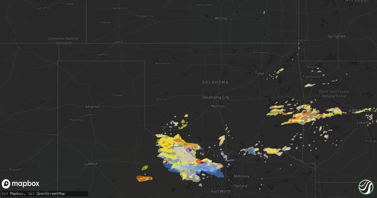
Hail Map in Oklahoma on May 22, 2020
Get this storm
May 22 map
$229
one time, instant access
Download today. No call, no setup
Keep the $229
Bought the map and want the full workflow? Apply the entire $229 to a subscription within 7 days. None of it is wasted.
Every map, not just this one
This buys you this map. Subscription and you get every map we run, in the markets you choose from a few cities to whole states to nationwide. Plus real-time alerts the moment a storm fires.
Contact data
Name, contact info, occupancy, even credit band for addresses in the footprint. You go from where it hit to who to call.
Become the source they trust
Unlimited branding weather history reports on demand. You already have the documented answer ready for the property owner, and you are the one who showed up with it.
Property data and RoofTrace estimates
Pull up any address you have got, its value and the exact code rules for that jurisdiction, straight from One Click Code. Then RoofTrace estimates the squares, pitch, and roof value, priced the way you price.
Storm reports in Oklahoma
Oklahoma
| Date | Description |
|---|---|
| 05/22/20206:15 PM CDT | A local report indicates 1.00 inch wind near INDIAHOMA |
| 05/22/20206:11 PM CDT | A local report indicates 1.00 inch wind near CACHE |
| 05/22/20205:52 PM CDT | A local report indicates 1.00 inch wind near 7 W GRANDFIELD |
| 05/22/20205:52 PM CDT | A local report indicates 2.50 inch wind near DAVIDSON |
| 05/22/20205:40 PM CDT | A local report indicates 1.50 inch wind near 4 S HOLLISTER |
| 05/22/20205:35 PM CDT | A local report indicates 2.00 inch wind near 9 E DAVIDSON |
| 05/22/20205:26 PM CDT | A local report indicates 4.00 inch wind near 7 E DAVIDSON |
| 05/22/20205:17 PM CDT | A local report indicates 1.00 inch wind near HOLLISTER |
| 05/22/20208:55 AM CDT | Em reports electric line down in vian. Time estimated from radar. |
| 05/22/20206:58 AM CDT | At 1158 PM CDT, a severe thunderstorm was located over Morgan Springs, or 15 miles west of Waldron, moving east at 30 mph. HAZARD...60 mph wind gusts and quarter size hail. SOURCE...Radar indicated. IMPACT...Hail damage to vehicles is expected. Expect wind damage to roofs, siding, and trees. Locations impacted include... Waldron... Mansfield... Oliver... Morgan Springs... Bates... Cauthron... Winfield... Hon... Liberty... |
| 05/22/20206:45 AM CDT | At 1144 PM CDT, a severe thunderstorm was located 5 miles south of Davidson, moving east at 30 mph. HAZARD...60 mph wind gusts and quarter size hail. SOURCE...Radar indicated. IMPACT...Hail damage to vehicles is expected. Expect wind damage to roofs, siding, and trees. Locations impacted include... Electra, Grandfield, Davidson, Loveland, Harrold, Oklaunion and Haynesville. |
| 05/22/20206:17 AM CDT | At 1116 PM CDT, a severe thunderstorm was located near Lake Kiowa, or near Whitesboro, moving east at 45 mph. HAZARD...60 mph wind gusts and quarter size hail. SOURCE...Radar indicated. IMPACT...Hail damage to vehicles is expected. Expect wind damage to roofs, siding, and trees. Locations impacted include... Sherman, Denison, Gainesville, Whitesboro, Van Alstyne, Howe, Pottsboro, Collinsville, Whitewright, Muenster, Gunter, Bells, Tom Bean, Lindsay, Callisburg, Knollwood, Dorchester, Lake Kiowa, Ray Roberts Park Johnson Branch and Eisenhower State Park.This includes Interstate 35 between mile markers 482 and 503. |
| 05/22/20206:07 AM CDT | At 1107 AM CDT, a severe thunderstorm was located over Vandervoort, or 15 miles southwest of Mena, moving east at 45 mph. HAZARD...60 mph wind gusts and quarter size hail. SOURCE...Radar indicated. IMPACT...Hail damage to vehicles is expected. Expect wind damage to roofs, siding, and trees. Locations impacted include... Wickes... Hatfield... Norman... Oden... Vandervoort... Opal... Mimosa... Little Missouri Falls Recreatio... Cossatot River State Park... Mena Intermountain Airport... Mccauley... Shady... Hartley... Bard Springs Recreation Area... Caney Creek Wilderness... Cove... Black Springs... Big Fork... Board Camp... Ink... |
| 05/22/20205:54 AM CDT | At 1054 PM CDT, a severe thunderstorm was located near Lockett, moving east at 35 mph. HAZARD...60 mph wind gusts and quarter size hail. SOURCE...Radar indicated. IMPACT...Hail damage to vehicles is expected. Expect wind damage to roofs, siding, and trees. Locations impacted include... Vernon, Electra, Oklaunion, Lockett, Harrold and Haynesville. |
| 05/22/20205:13 AM CDT | At 1013 PM CDT, a severe thunderstorm was located 5 miles southwest of Grayback, moving northeast at 25 mph. HAZARD...60 mph wind gusts and quarter size hail. SOURCE...Radar indicated. IMPACT...Hail damage to vehicles is expected. Expect wind damage to roofs, siding, and trees. Locations impacted include... Electra, Davidson, Oklaunion, Harrold, Grayback and Haynesville. |
| 05/22/20204:30 AM CDT | At 930 PM CDT, severe thunderstorms were located along a line extending from near Oklaunion to 9 miles north of Electra, moving northeast at 25 mph. HAZARD...Ping pong ball size hail and 60 mph wind gusts. SOURCE...Radar indicated. IMPACT...People and animals outdoors will be injured. Expect hail damage to roofs, siding, windows, and vehicles. Expect wind damage to roofs, siding, and trees. Locations impacted include... Burkburnett, Electra, Grandfield, Randlett, Devol, Loveland, Oklaunion, Harrold and Haynesville. |
| 05/22/20204:17 AM CDT | At 917 PM CDT, a severe thunderstorm was located near Iowa Park, moving east at 15 mph. HAZARD...Ping pong ball size hail and 60 mph wind gusts. SOURCE...Radar indicated. IMPACT...People and animals outdoors will be injured. Expect hail damage to roofs, siding, windows, and vehicles. Expect wind damage to roofs, siding, and trees. Locations impacted include... Wichita Falls, Burkburnett, Iowa Park, Dean, Jolly, Sheppard AFB, Pleasant Valley, Charlie and Cashion. |
| 05/22/20204:09 AM CDT | At 909 PM CDT, a severe thunderstorm was located near Stoneburg, or near Bowie, moving east at 20 mph. HAZARD...Two inch hail and 60 mph wind gusts. SOURCE...Radar indicated. IMPACT...People and animals outdoors will be injured. Expect hail damage to roofs, siding, windows, and vehicles. Expect wind damage to roofs, siding, and trees. Locations impacted include... Bowie, Nocona, Alvord, St. Jo, Sunset, Stoneburg, Forestburg and Newport. |
| 05/22/20203:45 AM CDT | At 845 PM CDT, a severe thunderstorm was located 4 miles south of Fort Cobb, moving northeast at 30 mph. HAZARD...Ping pong ball size hail and 60 mph wind gusts. SOURCE...Radar indicated. IMPACT...People and animals outdoors will be injured. Expect hail damage to roofs, siding, windows, and vehicles. Expect wind damage to roofs, siding, and trees. Locations impacted include... Anadarko, Binger, Fort Cobb, Gracemont, Lookeba, Albert, Fort Cobb Reservoir and Lake Chickasha. |
| 05/22/20203:19 AM CDT | At 819 PM CDT, severe thunderstorms were located along a line extending from near Frederick to 8 miles southwest of Grandfield, moving northeast at 20 mph. HAZARD...Ping pong ball size hail and 60 mph wind gusts. SOURCE...Radar indicated. IMPACT...People and animals outdoors will be injured. Expect hail damage to roofs, siding, windows, and vehicles. Expect wind damage to roofs, siding, and trees. Locations impacted include... Burkburnett, Frederick, Grandfield, Chattanooga, Randlett, Devol, Faxon, Hollister, Loveland and Cookietown. |
| 05/22/20203:13 AM CDT | At 812 PM CDT, a severe thunderstorm was located near Meers, moving northeast at 20 mph. HAZARD...Quarter size hail. SOURCE...Trained weather spotters report quarter size hail in Meers. IMPACT...Damage to vehicles is expected. Locations impacted include... Meers, Boone, Stecker and northeastern Wichita Mountains Wildlife Refuge. |
| 05/22/20203:10 AM CDT | At 809 PM CDT, a severe thunderstorm was located 6 miles southwest of Blocker, moving northeast at 20 mph. HAZARD...60 mph wind gusts and quarter size hail. SOURCE...Radar indicated. IMPACT...Hail damage to vehicles is expected. Expect wind damage to roofs, siding, and trees. Locations in or near the path include... Krebs... Quinton... Crowder... Alderson... Blocker... Robbers Cave State Park... Enterprise... Featherston... |
| 05/22/20202:54 AM CDT | At 753 PM CDT, a severe thunderstorm was located near Sheppard AFB, moving east at 30 mph. This is a very dangerous storm. HAZARD...Up to three inch hail and 60 mph wind gusts. SOURCE...Radar indicated. IMPACT...People and animals outdoors will be severely injured. Expect shattered windows, extensive damage to roofs, siding, and vehicles. Locations impacted include... Wichita Falls, Burkburnett, Henrietta, Iowa Park, Petrolia, Dean, Jolly, Sheppard AFB, Pleasant Valley and Cashion. |
| 05/22/20202:43 AM CDT | At 743 PM CDT, a severe thunderstorm was located 6 miles northeast of Indiahoma, moving northeast at 25 mph. HAZARD...Quarter size hail. SOURCE...Radar indicated. IMPACT...Damage to vehicles is expected. Locations impacted include... Medicine Park, Lake Lawtonka, Meers, southwestern Lake Ellsworth, southwestern Fort Sill and Wichita Mountains Wildlife Refuge. |
| 05/22/20202:11 AM CDT | At 711 PM CDT, a severe thunderstorm was located 3 miles southwest of Talimena State Park, moving northeast at 20 mph. HAZARD...60 mph wind gusts and quarter size hail. SOURCE...Radar indicated. IMPACT...Hail damage to vehicles is expected. Expect wind damage to roofs, siding, and trees. Locations in or near the path include... Talihina... Wister... Fanshawe... Talimena State Park... Lake Wister State Park... Whitesboro... Summerfield... |
| 05/22/20201:57 AM CDT | At 656 PM CDT, a severe thunderstorm was located near Burkburnett, moving east at 15 mph. This is a very dangerous storm. HAZARD...Baseball size hail and 60 mph wind gusts. SOURCE...Trained weather spotters reported baseball size hail in Burkburnett. IMPACT...People and animals outdoors will be severely injured. Expect shattered windows, extensive damage to roofs, siding, and vehicles. Locations impacted include... Northern Wichita Falls, Burkburnett, Petrolia, Byers, Dean, Sheppard AFB, Charlie and Cashion. |
| 05/22/20201:56 AM CDT | A local report indicates 1.00 inch wind near 5 SE PRYOR |
| 05/22/20201:53 AM CDT | At 653 PM CDT, severe thunderstorms were located along a line extending from 6 miles west of Bellevue to 12 miles southeast of Windthorst, moving northeast at 30 mph. HAZARD...Ping pong ball size hail and 60 mph wind gusts. SOURCE...Radar indicated. IMPACT...People and animals outdoors will be injured. Expect hail damage to roofs, siding, windows, and vehicles. Expect wind damage to roofs, siding, and trees. Locations impacted include... Henrietta, Bellevue, Bluegrove, Vashti, Shannon and Joy. |
| 05/22/20201:41 AM CDT | At 641 AM CDT, a severe thunderstorm was located 4 miles northeast of Hennepin, moving east at 25 mph. HAZARD...60 mph wind gusts and quarter size hail. SOURCE...Radar indicated. IMPACT...Hail damage to vehicles is expected. Expect wind damage to roofs, siding, and trees. Locations impacted include... Pauls Valley, Sulphur, Davis, Wynnewood, Stratford, Byng, Roff, Elmore City, Katie, Byars, Fitzhugh, Hickory, Vanoss, Lake Of The Arbuckles, Antioch, Turner Falls, Hennepin and Whitebead. |
| 05/22/20201:24 AM CDT | At 624 AM CDT, severe thunderstorms were located along a line extending from 6 miles northwest of Paden to 3 miles west of Etowah, moving east at 35 mph. HAZARD...60 mph wind gusts and nickel size hail. SOURCE...Radar indicated. IMPACT...Expect damage to roofs, siding, and trees. Locations impacted include... Shawnee, Seminole, Tecumseh, Holdenville, Wewoka, Prague, Konawa, Wetumka, Maud, Earlsboro, Bowlegs, Asher, Tribbey, Wanette, Cromwell, Johnson, St. Louis, Sasakwa, Horntown and Yeager. |
| 05/22/20201:22 AM CDT | At 622 AM CDT, a severe thunderstorm was located near Goldsby, moving east at 35 mph. HAZARD...60 mph wind gusts and quarter size hail. SOURCE...Radar indicated. IMPACT...Hail damage to vehicles is expected. Expect wind damage to roofs, siding, and trees. Locations impacted include... Southeastern Oklahoma City, Norman, Newcastle, Purcell, Noble, Slaughterville, Lexington, Pink, Goldsby, Washington, Etowah, Stella, Lake Thunderbird and Little Axe. |
| 05/22/20201:22 AM CDT | At 622 PM CDT, a severe thunderstorm was located 5 miles southwest of Hollister, moving east at 15 mph. HAZARD...Golf ball size hail and 60 mph wind gusts. SOURCE...Radar indicated. IMPACT...People and animals outdoors will be injured. Expect hail damage to roofs, siding, windows, and vehicles. Expect wind damage to roofs, siding, and trees. Locations impacted include... Davidson, Hollister and Loveland. |
| 05/22/20201:20 AM CDT | At 620 PM CDT, a severe thunderstorm was located near Indiahoma, moving northeast at 20 mph. HAZARD...Quarter size hail. SOURCE...Trained weather spotters reported quarter size hail in Indiahoma. IMPACT...Damage to vehicles is expected. Locations impacted include... Cache, Medicine Park, Indiahoma, Meers, Lake Lawtonka, southwestern Fort Sill and Wichita Mountains Wildlife Refuge. |
| 05/22/202012:53 AM CDT | At 552 AM CDT, severe thunderstorms were located along a line extending from 3 miles southwest of Lindsay to near Pooleville, moving northeast at 25 mph. HAZARD...60 mph wind gusts and quarter size hail. SOURCE...Radar indicated. IMPACT...Hail damage to vehicles is expected. Expect wind damage to roofs, siding, and trees. Locations impacted include... Pauls Valley, Purcell, Davis, Lindsay, Wynnewood, Maysville, Elmore City, Wayne, Paoli, Katie, Foster, Tatums, Ratliff City, Graham, Pooleville, Antioch, Hennepin, Payne, Fox and Pernell. |
| 05/22/202012:47 AM CDT | At 546 PM CDT, a severe thunderstorm was located 5 miles southeast of Indiahoma, moving northeast at 30 mph. HAZARD...Quarter size hail. SOURCE...Radar indicated. IMPACT...Damage to vehicles is expected. Locations impacted include... Northwestern Lawton, Cache, Medicine Park, Indiahoma, Meers, Lake Lawtonka, Fort Sill and Wichita Mountains Wildlife Refuge. |
| 05/22/202012:45 AM CDT | A local report indicates 59 MPH wind near 6 SSE DURANT |
| 05/22/202012:40 AM CDT | Power pole down at main east of hwy 74 |
| 05/22/202012:40 AM CDT | A local report indicates 70 MPH wind near 5 SSW ALBANY |
| 05/22/202012:39 AM CDT | At 538 AM CDT, severe thunderstorms were located along a line extending from 3 miles southeast of Pawnee to near Oklahoma City, moving east at 45 mph. HAZARD...70 mph wind gusts and nickel size hail. SOURCE...Radar indicated. IMPACT...Expect considerable tree damage. Damage is likely to mobile homes, roofs, and outbuildings. Locations impacted include... Eastern Oklahoma City, northeastern Norman, Midwest City, Shawnee, Cushing, Seminole, Tecumseh, Chandler, Choctaw, Harrah, McLoud, Wewoka, Jones, Stroud, Nicoma Park, Prague, Pink, Yale, Luther and Meeker. |
| 05/22/202012:38 AM CDT | Large tree across highway 259 just north of sweet home road north of broken bow. |
| 05/22/202012:34 AM CDT | A local report indicates 75 MPH wind near DURANT |
| 05/22/202012:28 AM CDT | At 527 PM CDT, a severe thunderstorm was located 7 miles south of Hollister, moving east at 15 mph. This is a very dangerous storm. HAZARD...Three inch hail and 60 mph wind gusts. SOURCE...Radar indicated. IMPACT...People and animals outdoors will be severely injured. Expect shattered windows, extensive damage to roofs, siding, and vehicles. Locations impacted include... Burkburnett, Grandfield, Devol and Loveland. |
| 05/22/202012:13 AM CDT | At 512 AM CDT, a severe thunderstorm was located 4 miles southwest of Loco, moving northeast at 20 mph. HAZARD...60 mph wind gusts and quarter size hail. SOURCE...Radar indicated. IMPACT...Hail damage to vehicles is expected. Expect wind damage to roofs, siding, and trees. Locations impacted include... Velma, Tatums, Loco, Ratliff City, Graham and Fox. |
| 05/22/202012:07 AM CDT | At 507 AM CDT, severe thunderstorms were located along a line extending from 3 miles northwest of Pawnee to near Oklahoma City, moving east at 45 mph. HAZARD...70 mph wind gusts and nickel size hail. SOURCE...Radar indicated. IMPACT...Expect considerable tree damage. Damage is likely to mobile homes, roofs, and outbuildings. Locations impacted include... Oklahoma City, northeastern Norman, Edmond, Midwest City, Stillwater, Shawnee, Del City, Guthrie, Cushing, Seminole, Tecumseh, Chandler, Bethany, Choctaw, Warr Acres, The Village, Harrah, McLoud, Spencer and Nichols Hills. |
| 05/22/202012:03 AM CDT | At 503 AM CDT, a severe thunderstorm was located 3 miles west of Sooner Lake, moving east at 40 mph. HAZARD...60 mph wind gusts and nickel size hail. SOURCE...Radar indicated. IMPACT...Expect damage to roofs, siding, and trees. Locations in or near the path include... Pawnee... Fairfax... Jennings... Ralston... Hallett... Blackburn... Maramec... Skedee... |
| 05/21/202011:57 PM CDT | At 456 PM CDT, a severe thunderstorm was located 6 miles southwest of Hollister, moving northeast at 35 mph. HAZARD...60 mph wind gusts and quarter size hail. SOURCE...Radar indicated. IMPACT...Hail damage to vehicles is expected. Expect wind damage to roofs, siding, and trees. Locations impacted include... Frederick, Grandfield, Davidson, Hollister and Loveland. |
| 05/21/202011:24 PM CDT | At 424 AM CDT, severe thunderstorms were located along a line extending from 3 miles north of Billings to 8 miles north of Lucien to 5 miles northwest of Piedmont, moving east at 45 mph. HAZARD...70 mph wind gusts and nickel size hail. SOURCE...Radar indicated. IMPACT...Expect considerable tree damage. Damage is likely to mobile homes, roofs, and outbuildings. Locations impacted include... Northeastern Oklahoma City, Edmond, Stillwater, Guthrie, Perry, Kingfisher, Piedmont, Perkins, Jones, Langston, Crescent, Luther, Okarche, Garber, Cashion, Morrison, Carney, Glencoe, Covington and Billings. |
| 05/21/202010:55 PM CDT | A local report indicates 62 MPH wind near BURNEYVILLE |
| 05/21/202010:40 PM CDT | At 339 AM CDT, severe thunderstorms were located along a line extending from near Carrier to near Drummond to 6 miles southeast of Ames, moving southeast at 35 mph. These are very dangerous storms. HAZARD...80 mph wind gusts and nickel size hail. SOURCE...Radar indicated. IMPACT...Flying debris will be dangerous to those caught without shelter. Mobile homes will be heavily damaged. Expect considerable damage to roofs, windows, and vehicles. Extensive tree damage and power outages are likely. Locations impacted include... Enid, Hennessey, Crescent, Waukomis, Garber, Covington, Drummond, Marshall, Breckenridge, Fairmont, Carrier, Douglas, Vance Air Force Base, Lovell, Lucien, Bison, North Enid, Hayward and Lacey. |
| 05/21/202010:38 PM CDT | A local report indicates 1.00 inch wind near ENTERPRISE |
| 05/21/202010:15 PM CDT | Peach tree blown down. Damage to other large tree limbs. Shingles off a roof. Reported near the boswell rodeo arena. Time estimated via radar. |
| 05/21/202010:14 PM CDT | A local report indicates a tornado near 1 N WHITESBORO |
| 05/21/202010:06 PM CDT | At 306 AM CDT, severe thunderstorms were located along a line extending from 3 miles south of Nash to 5 miles east of Cleo Springs, moving southeast at 20 mph. HAZARD...70 mph wind gusts and nickel size hail. SOURCE...Radar indicated. IMPACT...Expect considerable tree damage. Damage is likely to mobile homes, roofs, and outbuildings. Locations impacted include... Enid, Helena, Lahoma, Ringwood, Drummond, Kremlin, Goltry, Ames, Meno, Jet, Hunter, Hillsdale, Carrier, Vance Air Force Base and North Enid. |
| 05/21/202010:05 PM CDT | A local report indicates a tornado near 3 NW WHITESBORO |
| 05/21/20209:59 PM CDT | A local report indicates a tornado near 1 SE TALIHINA |
| 05/21/20209:12 PM CDT | At 211 AM CDT, a severe thunderstorm was located near Waynoka, moving northeast at 25 mph. HAZARD...60 mph wind gusts and quarter size hail. SOURCE...Radar indicated. IMPACT...Hail damage to vehicles is expected. Expect wind damage to roofs, siding, and trees. Locations impacted include... Waynoka, Avard and Hopeton. |
| 05/21/20208:58 PM CDT | A local report indicates 1.50 inch wind near 5 SW RANDLETT |
| 05/21/20208:56 PM CDT | A local report indicates 1.75 inch wind near 9 W ANADARKO |
| 05/21/20208:56 PM CDT | A local report indicates a tornado near 5 NE HEAVENER |
| 05/21/20208:51 PM CDT | At 151 AM CDT, a severe thunderstorm was located 8 miles northwest of Alabaster Caverns State Park, moving north at 35 mph. HAZARD...60 mph wind gusts and quarter size hail. SOURCE...Radar indicated. IMPACT...Hail damage to vehicles is expected. Expect wind damage to roofs, siding, and trees. Locations impacted include... Freedom, Alabaster Caverns State Park and Camp Houston. |
| 05/21/20208:32 PM CDT | A local report indicates 2.75 inch wind near HEAVENER |
| 05/21/20208:32 PM CDT | A local report indicates 1.75 inch wind near 1 S HEAVENER |
| 05/21/20208:25 PM CDT | A local report indicates 1.00 inch wind near 8 WNW BOONE |
| 05/21/20208:22 PM CDT | A local report indicates 1.50 inch wind near 1 E HODGEN |
| 05/21/20208:07 PM CDT | A local report indicates 1.00 inch wind near MEERS |
| 05/21/20208:01 PM CDT | A local report indicates 1.00 inch wind near WISTER |
| 05/21/20207:48 PM CDT | A local report indicates 1.00 inch wind near HOWE |
All States Impacted by Hail Map on May 22, 2020
Cities Impacted by Hail Map on May 22, 2020
- Sherwood, AR
- Jacksonville, AR
- Richton, MS
- Waynesboro, MS
- Ovett, MS
- Sarasota, FL
- Wister, OK
- Heavener, OK
- Alabaster, AL
- Vernon, TX
- Davidson, OK
- Claxton, GA
- Goodwater, AL
- Weogufka, AL
- Sylacauga, AL
- White Cloud, KS
- Highland, KS
- Laurel, MS
- Iowa Park, TX
- Sheppard Afb, TX
- Burkburnett, TX
- Wichita Falls, TX
- Wagoner, OK
- Chouteau, OK
- Parthenon, AR
- Ponca, AR
- Broken Bow, OK
- Seymour, TX
- Blackville, SC
- Allendale, SC
- Ulmer, SC
- Olar, SC
- Fort Towson, OK
- Valliant, OK
- Stigler, OK
- Red Oak, OK
- Alvord, TX
- Sunset, TX
- Forestburg, TX
- Talladega, AL
- Alpine, AL
- Gadsden, SC
- Eastover, SC
- Louisville, AL
- Griffithville, AR
- Oden, AR
- Mount Ida, AR
- Norman, AR
- Huntsville, TX
- Calhoun Falls, SC
- Abbeville, SC
- Iva, SC
- Richland, GA
- Preston, GA
- Des Arc, AR
- Addison, AL
- Bamberg, SC
- Hugo, OK
- Marion, AL
- Bowie, TX
- Bellevue, TX
- Harrold, TX
- Hollister, OK
- Frederick, OK
- Randlett, OK
- Loveland, OK
- Electra, TX
- Devol, OK
- Grandfield, OK
- Oklaunion, TX
- Huntington, AR
- Hackett, AR
- Greenwood, AR
- Jesup, GA
- Odum, GA
- Donalsonville, GA
- Waldron, AR
- Soso, MS
- Taylorsville, MS
- Maysville, GA
- Colbert, GA
- Nicholson, GA
- Commerce, GA
- Pendergrass, GA
- Hull, GA
- Danielsville, GA
- Jefferson, GA
- Huntsville, AR
- Goodspring, TN
- Prospect, TN
- Nocona, TX
- Saint Jo, TX
- Shelby, AL
- Columbiana, AL
- Montevallo, AL
- Randolph, AL
- Brierfield, AL
- Jemison, AL
- Calera, AL
- West Blocton, AL
- Winslow, AR
- West Fork, AR
- Prairie Grove, AR
- Gilbertown, AL
- Melvin, AL
- Whigham, GA
- Gainesville, TX
- Valley View, TX
- Lovelady, TX
- Vilonia, AR
- Mount Vernon, AR
- El Paso, AR
- Pineville, SC
- Eutawville, SC
- Cross, SC
- Rule, TX
- Aspermont, TX
- Old Glory, TX
- Haskell, TX
- Santee, SC
- Tifton, GA
- Sumner, GA
- Omega, GA
- Ty Ty, GA
- Arkadelphia, AR
- Comer, GA
- Carlton, GA
- Elberton, GA
- Bowman, GA
- Dewy Rose, GA
- Jayess, MS
- Scooba, MS
- Durant, OK
- Telephone, TX
- Bennington, OK
- Childersburg, AL
- Eutaw, AL
- Louin, MS
- Glenwood, AL
- Fort Smith, AR
- Quincy, FL
- Chattahoochee, FL
- Cumming, GA
- Canton, GA
- Alpharetta, GA
- Georgetown, GA
- Greenville, GA
- Yates Center, KS
- Wilson, OK
- Aiken, SC
- Ridge Spring, SC
- Estill, SC
- Monetta, SC
- Batesburg, SC
- Bokchito, OK
- Sumiton, AL
- Cordova, AL
- Dora, AL
- Anniston, AL
- Pine Apple, AL
- Howe, OK
- Poteau, OK
- Hodgen, OK
- Columbia, SC
- Blythewood, SC
- Elgin, SC
- Cape Coral, FL
- Quinton, OK
- Cuthbert, GA
- Locust Grove, OK
- Pryor, OK
- Conway, AR
- De Kalb, MS
- Shuqualak, MS
- Preston, MS
- Clopton, AL
- Ryan, OK
- Henrietta, TX
- Byers, TX
- Petrolia, TX
- Mena, AR
- Grady, AL
- Ramer, AL
- Jacksboro, TX
- Luray, SC
- Birmingham, AL
- Chesterfield, SC
- Ball Ground, GA
- Burneyville, OK
- Overbrook, OK
- Surrency, GA
- Chillicothe, TX
- Odell, TX
- Cullman, AL
- Falkville, AL
- Vinemont, AL
- Union Springs, AL
- Midway, AL
- Elkmont, AL
- Okolona, AR
- Harpersville, AL
- Windthorst, TX
- Eufaula, AL
- Clayton, AL
- Abbeville, AL
- Fort Gaines, GA
- Caddo Gap, AR
- Opelika, AL
- Cusseta, AL
- Valley, AL
- Sylvania, GA
- Pembroke, GA
- Booneville, AR
- Buford, GA
- Suwanee, GA
- Havana, AR
- Belleville, AR
- Mansfield, AR
- Fairfax, SC
- Danville, AR
- Cotton Plant, AR
- Iuka, MS
- Haworth, OK
- Gainesville, GA
- Talmo, GA
- Rosston, TX
- Montague, TX
- Decatur, TX
- Bay Springs, MS
- Stringer, MS
- Pearl River, LA
- Bryson, TX
- Monticello, MS
- Sontag, MS
- Newhebron, MS
- Caddo, OK
- Girard, GA
- Greenville, AL
- North Fort Myers, FL
- Horton, AL
- Boaz, AL
- Altus, OK
- Glenwood, AR
- Amity, AR
- Minor Hill, TN
- Perrin, TX
- Springdale, AR
- Hindsville, AR
- Rockford, AL
- Kellyton, AL
- Brooklet, GA
- Talihina, OK
- Ringgold, TX
- Elloree, SC
- Millry, AL
- Silas, AL
- Ellisville, MS
- Holliday, TX
- Saluda, SC
- Bottineau, ND
- Hatfield, AR
- Hartselle, AL
- Axson, GA
- Beebe, AR
- Roosevelt, OK
- Mountain Park, OK
- Snyder, OK
- Pottsboro, TX
- Lavaca, AR
- Ridgeland, SC
- Coosawhatchie, SC
- Yemassee, SC
- Lester, AL
- Brookwood, AL
- Glennville, GA
- Mccomb, MS
- Summit, MS
- Porterville, MS
- Ardmore, OK
- Springer, OK
- Dardanelle, AR
- Plainview, AR
- Ola, AR
- Dorchester, SC
- Harleyville, SC
- Nacogdoches, TX
- Dryden, TX
- Medicine Park, OK
- Petty, TX
- Roxton, TX
- Pittsview, AL
- Oregon, MO
- Forest Home, AL
- Georgiana, AL
- Carlisle, AR
- Lonoke, AR
- Middleburg, FL
- Bigelow, AR
- Mayflower, AR
- Varnville, SC
- Pineland, SC
- Early Branch, SC
- Reevesville, SC
- Lone Oak, TX
- Point, TX
- Troy, SC
- Bradley, SC
- Casa, AR
- Greenwood, SC
- Chappells, SC
- Silverstreet, SC
- Ninety Six, SC
- Cross Hill, SC
- Evergreen, AL
- Leesville, SC
- Newberry, SC
- Lexington, SC
- Chapin, SC
- Gilbert, SC
- Prosperity, SC
- Apache, OK
- Fort Cobb, OK
- Wyandotte, OK
- Lone Grove, OK
- Olney, TX
- Grant, OK
- Lincoln, AL
- Eastaboga, AL
- Boswell, OK
- Arthur City, TX
- Paris, TX
- Blossom, TX
- Detroit, TX
- Sawyer, OK
- Keota, OK
- Bokoshe, OK
- Spiro, OK
- Lugoff, SC
- York, AL
- Screven, GA
- Falls City, NE
- Hiawatha, KS
- Hurtsboro, AL
- Iron City, GA
- Garvin, OK
- Hartford, AR
- Ben Wheeler, TX
- Camden, AL
- Saint Matthews, SC
- Banks, AL
- Sterrett, AL
- Vincent, AL
- Jacksonville, GA
- Ocilla, GA
- Norman Park, GA
- Hartsville, SC
- Orangeburg, SC
- Atoka, OK
- Lane, OK
- Riverside, AL
- Pell City, AL
- Sheffield, TX
- Sabetha, KS
- Morrill, KS
- Muenster, TX
- Ariton, AL
- Skipperville, AL
- Weatherford, TX
- Whitt, TX
- Rosendale, MO
- King City, MO
- Union Star, MO
- Guilford, MO
- Rea, MO
- Helena, MO
- Savannah, MO
- Broken Arrow, OK
- Bridgeport, TX
- Fitzpatrick, AL
- Mathews, AL
- Fort Myers, FL
- Sims, AR
- Cache, OK
- Indiahoma, OK
- Epes, AL
- Livingston, AL
- Emelle, AL
- Troy, AL
- North, SC
- Swansea, SC
- Augusta, AR
- Ellabell, GA
- Little Rock, AR
- Blackshear, GA
- Waycross, GA
- Hatchechubbee, AL
- Clanton, AL
- McCrory, AR
- Wynne, AR
- Hickory Ridge, AR
- Kinta, OK
- Mccurtain, OK
- Loving, TX
- Chico, TX
- Jermyn, TX
- Newville, AL
- Elmer, OK
- Graham, TX
- Colquitt, GA
- Marbury, AL
- Verbena, AL
- Bogue Chitto, MS
- Ruth, MS
- Flowery Branch, GA
- Archer City, TX
- Scotland, TX
- Neeses, SC
- Honey Grove, TX
- Sumner, TX
- Fosters, AL
- Moundville, AL
- Flower Mound, TX
- Lewisville, TX
- Hampton, SC
- Ocoee, FL
- Apopka, FL
- Bokeelia, FL
- Davis, OK
- Sulphur, OK
- Irmo, SC
- Keysville, GA
- Pocola, OK
- Fort Davis, AL
- Hardaway, AL
- Martin, SC
- Equality, AL
- Headland, AL
- Paradise, TX
- Grapeland, TX
- Crockett, TX
- Jakin, GA
- Protem, MO
- Florence, SC
- Newington, GA
- Leesburg, GA
- Albany, GA
- Lagrange, GA
- Rembert, SC
- Brinkley, AR
- Knoxville, AL
- Selma, AL
- Tyler, AL
- Thomasville, AL
- Leoma, TN
- Lawrenceburg, TN
- Peterman, AL
- Beatrice, AL
- Little Mountain, SC
- Sumter, SC
- Cameron, OK
- Harrisburg, AR
- Bagwell, TX
- Powderly, TX
- Oakwood, GA
- Alexander City, AL
- Warwick, GA
- Ashburn, GA
- Tipton, OK
- Delta, AL
- Oxford, AL
- Munford, AL
- Heflin, AL
- Tuscaloosa, AL
- Walters, OK
- Danville, AL
- Marietta, OK
- Thackerville, OK
- Nicholls, GA
- Fillmore, MO
- McRae, AR
- Ivanhoe, NC
- Blountsville, AL
- Boligee, AL
- Keota, IA
- Washington, IA
- Mcalester, OK
- Wilburton, OK
- Lapine, AL
- Johnston, SC
- Anderson, MO
- Henderson, TX
- Barnwell, SC
- Wynnewood, OK
- Cheraw, SC
- Denmark, SC
- Sallisaw, OK
- Headrick, OK
- Inola, OK
- Carnegie, OK
- Seneca, MO
- Goodman, MO
- Jasper, GA
- Baxley, GA
- Boles, AR
- Magnolia, MS
- Forest City, MO
- Craig, MO
- Ludowici, GA
- Jacksonville, FL
- Pencil Bluff, AR
- Bogata, TX
- Register, GA
- Harvey, AR
- Newton, MS
- Decatur, MS
- Cherry Valley, AR
- Dothan, AL
- Atkinson, NC
- Aliceville, AL
- Dry Branch, GA
- Macon, GA
- Ridgeway, SC
- McCormick, SC
- Mount Carmel, SC
- Annona, TX
- Columbia, AL
- Damascus, GA
- Norway, SC
- McKenzie, AL
- Heidelberg, MS
- Muldrow, OK
- Butler, AL
- Neosho, MO
- Jay, OK
- Grove, OK
- Rogers, AR
- Athens, AL
- Brundidge, AL
- Biscoe, AR
- Stella, MO
- Nashville, AR
- Naples, FL
- Fairview, KS
- Gay, GA
- Pine Mountain, GA
- Bascom, FL
- Trussville, AL
- Porum, OK
- Checotah, OK
- Wheatley, AR
- Watson, OK
- Houston, AR
- Montgomery, AL
- Highland Home, AL
- Luverne, AL
- Bessemer, AL
- Fairfield, AL
- Dolomite, AL
- Ozark, AL
- Cades, SC
- Seminary, MS
- Ashland, AL
- Kingston, OK
- Mead, OK
- Calera, OK
- Safford, AL
- Orrville, AL
- Wagarville, AL
- Chandler, TX
- Brownsboro, TX
- Doerun, GA
- Bluffton, AR
- Parks, AR
- Rover, AR
- Midland, AR
- Shady Point, OK
- Briggsville, AR
- Gravelly, AR
- Colbert, OK
- Meridian, MS
- Alto, TX
- Collinsville, TX
- Omaha, GA
- Lumpkin, GA
- Cusseta, GA
- Buena Vista, GA
- De Queen, AR
- Campbell, TX
- Oskaloosa, IA
- Mineral Wells, TX
- Murfreesboro, AR
- Mound City, MO
- Maitland, MO
- Lenox, TN
- Dyersburg, TN
- Bowdon, GA
- Newcastle, TX
- Shellman, GA
- Johnson, NE
- Searcy, AR
- Cabot, AR
- Little Rock Air Force Base, AR
- North Little Rock, AR
- Brent, AL
- Zellwood, FL
- Marion Junction, AL
- Uniontown, AL
- Sarcoxie, MO
- Diamond, MO
- Granby, MO
- Canehill, AR
- Dawsonville, GA
- Charleston, AR
- Ringling, OK
- Pettigrew, AR
- Letohatchee, AL
- Poulan, GA
- Lawton, OK
- Vance, SC
- Wills Point, TX
- Mershon, GA
- Dunseith, ND
- Shubuta, MS
- Lawrence, MS
- Goshen, AL
- Pelham, AL
- Statesboro, GA
- Cayce, SC
- West Columbia, SC
- Hopkins, SC
- Franklin, GA
- Macon, MS
- Athens, GA
- Moody, AL
- Leeds, AL
- Petal, MS
- Trinity, TX
- Guntersville, AL
- Joplin, MO
- Dierks, AR
- Andalusia, AL
- Ward, AR
- Everton, AR
- Rulo, NE
- Duncanville, AL
- Hobart, OK
- Branchville, SC
- Era, TX
- Ehrhardt, SC
- Crowell, TX
- Sanger, TX
- Eldorado, OK
- Rutledge, AL
- Tuskegee, AL
- Marked Tree, AR
- Trumann, AR
- Trenton, SC
- Coweta, OK
- Lauderdale, MS
- Patrick, SC
- McBee, SC
- Leslie, GA
- Americus, GA
- Eufaula, OK
- Lowndesville, SC
- Smithville, OK
- Dawson, GA
- Weston, GA
- Parrott, GA
- Woodstock, GA
- Lockesburg, AR
- Stark City, MO
- Pierce City, MO
- Washburn, MO
- Edgefield, SC
- Witter, AR
- Combs, AR
- Saint Paul, AR
- Brookston, TX
- Holly Pond, AL
- Arab, AL
- Troy, KS
- Amazonia, MO
- Winter Garden, FL
- Garnett, SC
- Collins, MS
- Morris, GA
- Coleman, GA
- Fisher, AR
- Whitefield, OK
- Canadian, OK
- Elba, AL
- Scott, AR
- Jack, AL
- Loretto, TN
- Pinson, AL
- Springville, AL
- Arlington, TN
- Millington, TN
- Memphis, TN
- Earle, AR
- Turrell, AR
- Crawfordsville, AR
- West Memphis, AR
- Parkin, AR
- Proctor, AR
- Marion, AR
- Forrest City, AR
- Colt, AR
- Tyronza, AR
- Gans, OK
- Salina, OK
- Ivanhoe, TX
- Wathena, KS
- Salem, NE
- Pinola, MS
- Homer, GA
- Royston, GA
- Carnesville, GA
- Gillsville, GA
- Hartwell, GA
- Starr, SC
- Anderson, SC
- Hogansville, GA
- Byromville, GA
- Elko, GA
- Hawkinsville, GA
- Unadilla, GA
- Vienna, GA
- Pinehurst, GA
- Perry, GA
- Jeffersonville, GA
- Cochran, GA
- Danville, GA
- Irwinton, GA
- Gainesville, AL
- Brunson, SC
- Cameron, SC
- Summerton, SC
- Dalzell, SC
- Shaw Afb, SC
- Bowman, SC
- Rowesville, SC
- Holly Hill, SC
- Van, TX
- O'Brien, TX
- Paducah, TX
- Knox City, TX
- Temple, OK
- Saint Petersburg, FL
- Orlando, FL
- Denton, TX
- Ponder, TX
- Rhome, TX
- Krum, TX
- Justin, TX
- Whitesboro, TX
- Throckmorton, TX
- Teachey, NC
- Clinton, NC
- Garland, NC
- Beulaville, NC
- Wallace, NC
- Magnolia, NC
- Richlands, NC
- Chinquapin, NC
- Rose Hill, NC
- Aberdeen, NC
- Rockingham, NC
- Hoffman, NC
- Raeford, NC
- Marston, NC
- Wagram, NC
- Hamlet, NC
- Pinebluff, NC
- Southern Pines, NC
- Vass, NC
- Spartanburg, SC
- Pacolet, SC
- Gaffney, SC
- Cowpens, SC
- Gastonia, NC
- Blacksburg, SC
- Clover, SC
- Kings Mountain, NC
- Smyrna, SC
- Hickory Grove, SC
- York, SC
- Sharon, SC
- Buffalo, SC
- Union, SC
- Jonesville, SC
- Pauline, SC
- Grover, NC
- Polkton, NC
- Oakboro, NC
- Mount Gilead, NC
- Norwood, NC


