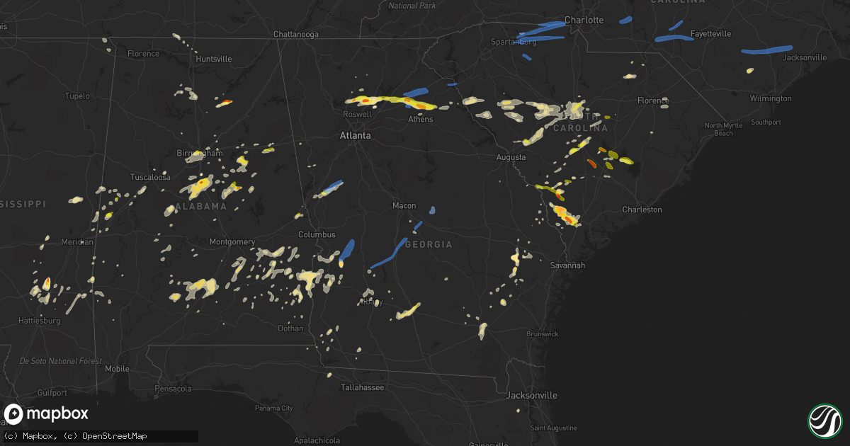
Hail Map in Georgia on May 22, 2020
Get this storm
May 22 map
$229
one time, instant access
Download today. No call, no setup
Keep the $229
Bought the map and want the full workflow? Apply the entire $229 to a subscription within 7 days. None of it is wasted.
Every map, not just this one
This buys you this map. Subscription and you get every map we run, in the markets you choose from a few cities to whole states to nationwide. Plus real-time alerts the moment a storm fires.
Contact data
Name, contact info, occupancy, even credit band for addresses in the footprint. You go from where it hit to who to call.
Become the source they trust
Unlimited branding weather history reports on demand. You already have the documented answer ready for the property owner, and you are the one who showed up with it.
Property data and RoofTrace estimates
Pull up any address you have got, its value and the exact code rules for that jurisdiction, straight from One Click Code. Then RoofTrace estimates the squares, pitch, and roof value, priced the way you price.
Storm reports in Georgia
Georgia
| Date | Description |
|---|---|
| 05/22/20206:58 PM CDT | Tree down at salem church road near mullis white road. |
| 05/22/20206:40 PM CDT | Emergency manager reports several trees downa long highway 26 between elko and brown hill rd. |
| 05/22/20205:51 PM CDT | Tree down along tallent store road. |
| 05/22/20205:51 PM CDT | Tree down along north end of orchid drive. |
| 05/22/20205:49 PM CDT | Tree down along leslie-lamar road |
| 05/22/20205:47 PM CDT | Tree down at hwy 30 and dupree road |
| 05/22/20205:35 PM CDT | Emergency manager reports 4 trees down on powerlines northwest of ellaville. |
| 05/22/20205:35 PM CDT | Emergency manager reports 4 trees down on powerlines within the city limits of ellaville. |
| 05/22/20205:25 PM CDT | Trees down new york road between mossy dell road and raines lane. |
| 05/22/20205:23 PM CDT | Trees down on canal street and powerlines down on on walnut street at the intersection of callaway street. Several hundred power outages in the area. |
| 05/22/20205:20 PM CDT | Emergency manager reports golf ball sized hail in downtown preston and also numerous trees down along highway 41 just north of preston. |
| 05/22/20205:13 PM CDT | Tree down at hwy 280 and cucumber road |
| 05/22/20205:04 PM CDT | Several trees down just east of alvaton along hwy 362 |
| 05/22/20205:01 PM CDT | Tree down along moores store road in northern stewart co |
| 05/22/20204:55 PM CDT | Large oak split and fell on a house... Damaging 2 cars as well near intersection of clark road and greenville st. |
| 05/22/20204:49 PM CDT | Multiple trees down along valley road in lumpkin |
| 05/22/20204:49 PM CDT | City of lumpkin - multiple trees down along valley road... Powerlines down on liberty street... Tree down on outbuilding on broad street |
| 05/22/20204:38 PM CDT | Large tree down on phillip causey road. |
| 05/22/20204:27 PM CDT | Large tree down on us-82 along with several hundred power outages in the georgetown area. |
| 05/22/20204:11 PM CDT | Large tree down on cotton hill road. |
| 05/22/20201:20 PM CDT | A coop observer 6 miles west of danielsville reported hail 1 inch in diameter. |
| 05/22/20201:04 PM CDT | The banks county highway department reported a tree blown down across highway 59 in front of the beaver dam baptist church. |
| 05/22/202012:53 PM CDT | Several trees down along plainview road. Several more along deadwyler road. |
| 05/22/202012:51 PM CDT | Tree down along dry pond road near i-85 |
| 05/22/202012:40 PM CDT | 3 trees down along old gainesville hwy in pendergrass |
| 05/22/202012:39 PM CDT | The highway department in jackson county reported a tree blown down across the roadway blocking both lanes on cottage loop near the intersection of highway 332 and broo |
| 05/22/202012:37 PM CDT | 1 tree down along murphy road near pendergrass |
| 05/22/202012:35 PM CDT | Tree down along talmo trail |
| 05/22/202012:22 PM CDT | Powerlines down near the intersection of ga hwy 211 and winder hwy |
| 05/22/202012:10 PM CDT | A trained spotter reported hail the size of golf balls 1 mile north of cumming. |
| 05/22/202012:05 PM CDT | The public reported hail the size of quaters to half-dollars near the polo golf and country club. |
| 05/22/202011:59 AM CDT | The cherokee county emergency manager reported a tree blown down along aj land road. |
| 05/22/202011:50 AM CDT | The cherokee county emergency manager reported 3 trees blown down along union hill road. |
| 05/22/202011:42 AM CDT | The cherokee county emergency manager reported a tree blown down onto a vehicle and a mobile home causing significant damage. No injuries were reported. |
| 05/22/20207:38 AM CDT | At 1237 PM EDT, a severe thunderstorm was located over Union Hill, or near Canton, moving east at 35 mph. HAZARD...60 mph wind gusts and quarter size hail. SOURCE...Radar indicated. IMPACT...Hail damage to vehicles is expected. Expect wind damage to roofs, siding, and trees. Locations impacted include... Canton, Cumming, Milton, Holly Springs, Free Home, Buffington, Dougherty, Hickory Flat, Drew, Union Hill, Coal Mountain, Hightower, Birmingham, Matt, Silver City, Holbrook, Lathemtown, Ducktown and Lake Lanier Islands. |
| 05/22/20204:46 AM CDT | At 945 PM EDT, severe thunderstorms were located along a line extending from near Nevils to near Walthourville, moving northeast at 45 mph. HAZARD...60 mph wind gusts and quarter size hail. SOURCE...Radar indicated. IMPACT...Minor hail damage to vehicles is possible. Expect wind damage to trees and powerlines. Locations impacted include... Hinesville, Statesboro, Glennville, Claxton, Pembroke, Ludowici, Fort Stewart, Lanier, Walthourville, Brooklet, Hagan, Flemington, Gumbranch, Daisy and Bellville.This warning includes I-16 between mile markers 115 and 148. |
| 05/22/20204:17 AM CDT | At 916 PM EDT, a severe thunderstorm was located near Needham, moving northeast at 5 mph. Another storm southwest of Needham could become severe. HAZARD...60 mph wind gusts and quarter size hail. SOURCE...Radar indicated. IMPACT...Hail damage to vehicles is expected. Expect wind damage to roofs, siding, and trees. Locations impacted include... Waycross, Boggy Bay, Manor and Needham. |
| 05/22/20203:33 AM CDT | At 833 PM EDT, a severe thunderstorm was located near Screven, or 9 miles west of Jesup, moving northeast at 5 mph. HAZARD...60 mph wind gusts and quarter size hail. SOURCE...Radar indicated. IMPACT...Hail damage to vehicles is expected. Expect wind damage to roofs, siding, and trees. This severe thunderstorm will remain over mainly rural areas of west central Wayne County. |
| 05/22/20202:59 AM CDT | At 759 PM EDT, severe thunderstorms were located along a line extending from near Warner Robins to near Bullard to near District Path, moving northeast at 55 mph. HAZARD...60 mph wind gusts and nickel size hail. SOURCE...Radar indicated. IMPACT...Expect damage to roofs, siding, and trees. Locations impacted include... Jeffersonville, Warner Robins, Robins Air Force Base, Marion, Bullard, Houston Lake, Fitzpatrick, Ripley, Huber, District Path, Elberta, Bonaire and Kathleen. |
| 05/22/20202:43 AM CDT | At 742 PM EDT, a severe thunderstorm was located near Royal, or 7 miles northwest of Cochran, moving east at 25 mph. HAZARD...60 mph wind gusts and quarter size hail. SOURCE...Radar indicated. IMPACT...Hail damage to vehicles is expected. Expect wind damage to roofs, siding, and trees. Locations impacted include... Danville, Royal, Coley Station, Tarversville, Goldsboro, Rebie, Cary, Porter and Magnolia. |
| 05/22/20202:29 AM CDT | At 728 PM EDT, a severe thunderstorm was located over Elko, or 8 miles south of Perry, moving northeast at 45 mph. HAZARD...60 mph wind gusts and nickel size hail. SOURCE...Radar indicated. IMPACT...Expect damage to roofs, siding, and trees. Locations impacted include... Perry, Unadilla, Pinehurst, Hayneville, Meadowdale, Sand Bed, Houston Lake, Grovania, Elko, Grove Park, Moss Oak, Henderson, Klondike and Clinchfield. |
| 05/22/20202:12 AM CDT | At 712 PM EDT/612 PM CDT/, a severe thunderstorm was located 9 miles southeast of Abbeville, moving northeast at 25 mph. HAZARD...60 mph wind gusts and nickel size hail. SOURCE...Radar indicated. IMPACT...Expect damage to roofs, siding, and trees. Locations impacted include... Fort Gaines, Haleburg, Shorterville, Walter F. George Lock And Dam, Barnes, Tumbleton, Miller, Hardwickburg, Zetto, Hayes, Willis Crossroads and Balkum. |
| 05/22/20201:48 AM CDT | At 647 PM EDT, a severe thunderstorm was located near Leslie, or 10 miles north of Leesburg, moving north at 30 mph. HAZARD...60 mph wind gusts and quarter size hail. SOURCE...Radar indicated. IMPACT...Hail damage to vehicles is expected. Expect wind damage to roofs, siding, and trees. Locations impacted include... Smithville, Scrutchins and Chokee. |
| 05/22/20201:46 AM CDT | At 646 PM EDT, severe thunderstorms were located along a line extending from near Maddox to Huntington to De Soto to near Warwick, moving northeast at 30 mph. HAZARD...60 mph wind gusts and nickel size hail. SOURCE...Radar indicated. IMPACT...Expect damage to roofs, siding, and trees. Locations impacted include... Americus, Leslie, De Soto, Desoto, Cobb, Sumter, Lamar, Fort Early, Georgia Veterans Memorial St Pk, Croxton Crossroads, New Era, Huntington, Pennington, Drayton, Maddox and Methvins. |
| 05/22/20201:44 AM CDT | At 643 PM EDT, severe thunderstorms were located along a line extending from Seigling to 7 miles southeast of Burtons Ferry Landing, moving east at 25 mph. HAZARD...60 mph wind gusts and quarter size hail. SOURCE...Radar indicated. IMPACT...Minor hail damage to vehicles is possible. Expect wind damage to trees and powerlines. Locations impacted include... Allendale, Hampton, Varnville, Fairfax, Brunson, Gifford, Sycamore, Lodge, Ulmer, Crocketville, Seigling, Miley, Barton, Ashton and Appleton. |
| 05/22/20201:25 AM CDT | At 624 PM EDT, a severe thunderstorm was located over Buena Vista, moving northeast at 35 mph. HAZARD...60 mph wind gusts and nickel size hail. SOURCE...Radar indicated. IMPACT...Expect damage to roofs, siding, and trees. Locations impacted include... Buena Vista, Butler, Putnam, Brantley, Rupert, Charing, Oakland, Zellobee, Potterville, Mauk, Tazewell, Marion Estates and Doyle. |
| 05/22/20201:19 AM CDT | At 618 PM EDT, a severe thunderstorm was located over Leesburg, moving northeast at 20 mph. HAZARD...60 mph wind gusts and quarter size hail. SOURCE...Radar indicated. IMPACT...Hail damage to vehicles is expected. Expect wind damage to roofs, siding, and trees. Locations impacted include... Leesburg, Albany, Smithville, Chokee, Forrester, Palmyra, Century, Jordan Place, Starksville, Byne Crossroads, Scrutchins, Armena, Neyami and Mossy Dell. |
| 05/22/20201:00 AM CDT | At 600 PM EDT, a severe thunderstorm was located over Wooster, or 8 miles northeast of Greenville, moving east at 15 mph. HAZARD...60 mph wind gusts and quarter size hail. SOURCE...Radar indicated. IMPACT...Hail damage to vehicles is expected. Expect wind damage to roofs, siding, and trees. Locations impacted include... Zebulon, Williamson, Haralson, Gay, Alvaton, Rocky Mount, Digbey, Hilltop, Hollonville and Wooster. |
| 05/22/20201:00 AM CDT | At 600 PM EDT, a severe thunderstorm was located over Millett, moving east at 30 mph. HAZARD...60 mph wind gusts and quarter size hail. SOURCE...Radar indicated. IMPACT...Minor hail damage to vehicles is possible. Expect wind damage to trees and powerlines. Locations impacted include... Allendale, Sycamore, Ulmer, Seigling, Millett, Martin and Appleton. |
| 05/22/202012:51 AM CDT | At 551 PM EDT, a severe thunderstorm was located near Mystic, or near Ocilla, moving northeast at 20 mph. HAZARD...60 mph wind gusts and quarter size hail. SOURCE...Radar indicated. IMPACT...Hail damage to vehicles is expected. Expect wind damage to roofs, siding, and trees. Locations impacted include... Fitzgerald, Ocilla, Mystic, Irwinville, Osierfield, Fitzgerald Municipal A/P, Waterloo, Pinetta, Ashton, Abba and Irwinville Airport. |
| 05/22/202012:40 AM CDT | At 540 PM EDT, a severe thunderstorm was located near Savannah River Site, moving northeast at 25 mph. HAZARD...60 mph wind gusts and quarter size hail. SOURCE...Radar indicated. IMPACT...Hail damage to vehicles is expected. Expect wind damage to roofs, siding, and trees. Locations impacted include... Barnwell, Savannah River Site, Williston, Blackville, Barnwell State Park, Hilda, Snelling, Elko, Barnwell County Airport and Savannah River Site K Complex. |
| 05/22/202012:26 AM CDT | At 526 PM EDT, a severe thunderstorm was located over Big Springs, or 7 miles southeast of LaGrange, moving east at 25 mph. HAZARD...60 mph wind gusts and quarter size hail. SOURCE...Radar indicated. IMPACT...Hail damage to vehicles is expected. Expect wind damage to roofs, siding, and trees. Locations impacted include... LaGrange, Greenville, Woodbury, Warm Springs, Gay, Raleigh, Mountville, Odessadale, Stovall, Big Springs, Durand, Harris City, Imlac and Wooster. |
| 05/22/202012:24 AM CDT | At 524 PM EDT, a severe thunderstorm was located near Cuthbert, moving north at 15 mph. HAZARD...60 mph wind gusts and quarter size hail. SOURCE...Radar indicated. IMPACT...Hail damage to vehicles is expected. Expect wind damage to roofs, siding, and trees. Locations impacted include... Cuthbert, Springvale Station, Peterson Hill, Coles, White House, Brooksville, Benevolence, Springvale and Wades. |
| 05/21/202011:49 PM CDT | At 448 PM EDT/348 PM CDT/, a severe thunderstorm was located over Abbeville, moving north at 20 mph. HAZARD...60 mph wind gusts and nickel size hail. SOURCE...Radar indicated. IMPACT...Expect damage to roofs, siding, and trees. Locations impacted include... Abbeville, Walter F George Lake, Bonapartes Retreat, Standleys Store, Otho, Scottsboro Crossroads, Double Bridges, Ricks Place, Murphy Station, Graball, Screamer, Coates, Bagby State Park, Thomas Mill Creek, Lawrenceville, Abbeville Municipal A/P, Willis Crossroads and Days Crossroads. |
| 05/21/202011:31 PM CDT | At 431 PM EDT, a severe thunderstorm was located near Donalsonville, moving northeast at 10 mph. HAZARD...60 mph wind gusts and quarter size hail. SOURCE...Radar indicated. IMPACT...Hail damage to vehicles is expected. Expect wind damage to roofs, siding, and trees. Locations impacted include... Donalsonville, Iron City, Brinson, Cyrene, Sharphagen, Donaldsonville A/P, Davis Park, Little Hope, Enterprise, Lela and Eldorendo. |
| 05/21/202010:51 PM CDT | At 351 PM EDT, a severe thunderstorm was located over Greensboro, or 11 miles west of Quincy, moving northeast at 15 mph. HAZARD...60 mph wind gusts and quarter size hail. SOURCE...Radar indicated. IMPACT...Hail damage to vehicles is expected. Expect wind damage to roofs, siding, and trees. Locations impacted include... Quincy, Havana, Greensboro, Gretna, Attapulgus, Freemont, Littman, Juniper, Douglas City, Florence, Rosedale, Jamieson, Laingkat, Santa Clara, Shady Rest, Amsterdam, Quincy Airport, Branchville, Sawdust and Hinson. |
| 05/21/202010:45 PM CDT | At 345 PM EDT, a severe thunderstorm was located near Colquitt, moving northeast at 20 mph. HAZARD...60 mph wind gusts and quarter size hail. SOURCE...Radar indicated. IMPACT...Hail damage to vehicles is expected. Expect wind damage to roofs, siding, and trees. Locations impacted include... Colquitt, Damascus, Babcock, Crestview, Mayhaw, Boykin, Mimsville, Enterprise, Harmony Church Rd/hwy 45, Jeterville, Cooktown, Bethany and Bellview. |
| 05/21/202010:44 PM CDT | At 343 PM EDT, a severe thunderstorm was located 10 miles southeast of Elberton, or near Nancy Hart State Park, moving east at 35 mph. HAZARD...60 mph wind gusts and quarter size hail. SOURCE...Radar indicated. IMPACT...Minor hail damage to vehicles is expected. Expect wind damage to trees and power lines. Locations impacted include... Calhoun Falls, Nancy Hart State Park, Bobby Brown State Park, Lake Strom Thurmond, Broad River Campground, Richard B Russell Dam, Rice Town, Bobby Brown State Recreation Area and Lake Russell. |
| 05/21/202010:35 PM CDT | At 333 PM EDT, severe thunderstorms were located along a line extending from 6 miles west of Abbeville to near Nancy Hart State Park, moving east at 40 mph. HAZARD...60 mph wind gusts and quarter size hail. SOURCE...Radar indicated. IMPACT...Hail damage to vehicles is expected. Expect wind damage to roofs, siding, and trees. Locations impacted include... McCormick, Lincolnton, Mccormick County Airport, Elijah Clark State Park, Hickory Knob State Resort Park, Gill's Point, Bordeaux, Hester's Ferry Campground, Broad River Campground, Mount Carmel, Baker Creek State Park, Leroy's Ferry Recreation Area, Willington, Curry Hill, Mount Carmel Park, Chennault, Hawe Creek Campground and Long Cane Creek Picnic Area. |
| 05/21/20209:42 PM CDT | At 242 PM EDT, severe thunderstorms were located along a line extending from 11 miles south of Greenville Downtown to 5 miles northeast of Hartwell, moving east at 40 mph. HAZARD...60 mph wind gusts and quarter size hail. SOURCE...Radar indicated. IMPACT...Minor hail damage to vehicles is expected. Expect wind damage to trees and power lines. Locations impacted include... Anderson, Hartwell, Fountain Inn, Homeland Park, Belton, Williamston, Honea Path, Due West, Iva and Gray Court. |
| 05/21/20209:26 PM CDT | At 225 PM EDT, a severe thunderstorm was located 4 miles north of Danielsville, moving east at 40 mph. HAZARD...60 mph wind gusts and half dollar size hail. SOURCE...Radar indicated. IMPACT...Minor hail damage to vehicles is expected. Expect wind damage to trees and power lines. Locations impacted include... Elberton, Hartwell, Carnesville, Royston, Reed Creek, Bowman, Canon, Franklin Springs, Bowersville and Russell State Park. |
| 05/21/20209:10 PM CDT | At 209 PM EDT, a severe thunderstorm was located over Nicholson, or near Commerce, moving east at 30 mph. HAZARD...60 mph wind gusts and quarter size hail. SOURCE...Radar indicated. IMPACT...Hail damage to vehicles is expected. Expect wind damage to roofs, siding, and trees. Locations impacted include... Danielsville, Nicholson, Comer, Colbert, Carlton, Diamond Hill, Neese and Paoli. |
| 05/21/20209:01 PM CDT | At 201 PM EDT, a severe thunderstorm was located 5 miles north of Commerce, moving east at 30 mph. HAZARD...60 mph wind gusts and quarter size hail. SOURCE...Radar indicated. IMPACT...Minor hail damage to vehicles is expected. Expect wind damage to trees and power lines. Locations impacted include... Carnesville and Victoria Bryant State Park. |
| 05/21/20208:53 PM CDT | At 152 PM EDT, a severe thunderstorm was located near Peach State Speedway, or near Jefferson, moving east at 30 mph. HAZARD...60 mph wind gusts and quarter size hail. SOURCE...Radar indicated. IMPACT...Hail damage to vehicles is expected. Expect wind damage to roofs, siding, and trees. Locations impacted include... Commerce, Homer, Maysville, Ila, Pocataligo and Banks Crossing. |
| 05/21/20208:52 PM CDT | Media relayed report of golf ball sized hail at the intersection of highway 129 and highway 250. |
| 05/21/20208:51 PM CDT | Pictures relayed via social media of hail up to two inches in diameter in daisy. |
| 05/21/20208:17 PM CDT | At 117 PM EDT, a severe thunderstorm was located over Aqualand Park, or 9 miles southwest of Gainesville, moving east at 30 mph. HAZARD...60 mph wind gusts and quarter size hail. SOURCE...Radar indicated. IMPACT...Hail damage to vehicles is expected. Expect wind damage to roofs, siding, and trees. Locations impacted include... Gainesville, Jefferson, Flowery Branch, Oakwood, Lula, Maysville, Pendergrass, Gillsville, Talmo, Candler, Peach State Speedway, Aqualand Park, Chestnut Mountain, Oscarville, Road Atlanta-Lanier Speedway and Apple Valley. |
| 05/21/20208:03 PM CDT | Emergency manager reports several trees down in pierce county near old alma rd and west horshoe rd. Time based on radar. |
| 05/21/20207:24 PM CDT | 911 center reports numerous trees down along highway 96 near jeffersonville. |
| 05/21/20207:02 PM CDT | Tree down along hwy 112 in ne portion of county |
All States Impacted by Hail Map on May 22, 2020
Cities Impacted by Hail Map on May 22, 2020
- Sherwood, AR
- Jacksonville, AR
- Richton, MS
- Waynesboro, MS
- Ovett, MS
- Sarasota, FL
- Wister, OK
- Heavener, OK
- Alabaster, AL
- Vernon, TX
- Davidson, OK
- Claxton, GA
- Goodwater, AL
- Weogufka, AL
- Sylacauga, AL
- White Cloud, KS
- Highland, KS
- Laurel, MS
- Iowa Park, TX
- Sheppard Afb, TX
- Burkburnett, TX
- Wichita Falls, TX
- Wagoner, OK
- Chouteau, OK
- Parthenon, AR
- Ponca, AR
- Broken Bow, OK
- Seymour, TX
- Blackville, SC
- Allendale, SC
- Ulmer, SC
- Olar, SC
- Fort Towson, OK
- Valliant, OK
- Stigler, OK
- Red Oak, OK
- Alvord, TX
- Sunset, TX
- Forestburg, TX
- Talladega, AL
- Alpine, AL
- Gadsden, SC
- Eastover, SC
- Louisville, AL
- Griffithville, AR
- Oden, AR
- Mount Ida, AR
- Norman, AR
- Huntsville, TX
- Calhoun Falls, SC
- Abbeville, SC
- Iva, SC
- Richland, GA
- Preston, GA
- Des Arc, AR
- Addison, AL
- Bamberg, SC
- Hugo, OK
- Marion, AL
- Bowie, TX
- Bellevue, TX
- Harrold, TX
- Hollister, OK
- Frederick, OK
- Randlett, OK
- Loveland, OK
- Electra, TX
- Devol, OK
- Grandfield, OK
- Oklaunion, TX
- Huntington, AR
- Hackett, AR
- Greenwood, AR
- Jesup, GA
- Odum, GA
- Donalsonville, GA
- Waldron, AR
- Soso, MS
- Taylorsville, MS
- Maysville, GA
- Colbert, GA
- Nicholson, GA
- Commerce, GA
- Pendergrass, GA
- Hull, GA
- Danielsville, GA
- Jefferson, GA
- Huntsville, AR
- Goodspring, TN
- Prospect, TN
- Nocona, TX
- Saint Jo, TX
- Shelby, AL
- Columbiana, AL
- Montevallo, AL
- Randolph, AL
- Brierfield, AL
- Jemison, AL
- Calera, AL
- West Blocton, AL
- Winslow, AR
- West Fork, AR
- Prairie Grove, AR
- Gilbertown, AL
- Melvin, AL
- Whigham, GA
- Gainesville, TX
- Valley View, TX
- Lovelady, TX
- Vilonia, AR
- Mount Vernon, AR
- El Paso, AR
- Pineville, SC
- Eutawville, SC
- Cross, SC
- Rule, TX
- Aspermont, TX
- Old Glory, TX
- Haskell, TX
- Santee, SC
- Tifton, GA
- Sumner, GA
- Omega, GA
- Ty Ty, GA
- Arkadelphia, AR
- Comer, GA
- Carlton, GA
- Elberton, GA
- Bowman, GA
- Dewy Rose, GA
- Jayess, MS
- Scooba, MS
- Durant, OK
- Telephone, TX
- Bennington, OK
- Childersburg, AL
- Eutaw, AL
- Louin, MS
- Glenwood, AL
- Fort Smith, AR
- Quincy, FL
- Chattahoochee, FL
- Cumming, GA
- Canton, GA
- Alpharetta, GA
- Georgetown, GA
- Greenville, GA
- Yates Center, KS
- Wilson, OK
- Aiken, SC
- Ridge Spring, SC
- Estill, SC
- Monetta, SC
- Batesburg, SC
- Bokchito, OK
- Sumiton, AL
- Cordova, AL
- Dora, AL
- Anniston, AL
- Pine Apple, AL
- Howe, OK
- Poteau, OK
- Hodgen, OK
- Columbia, SC
- Blythewood, SC
- Elgin, SC
- Cape Coral, FL
- Quinton, OK
- Cuthbert, GA
- Locust Grove, OK
- Pryor, OK
- Conway, AR
- De Kalb, MS
- Shuqualak, MS
- Preston, MS
- Clopton, AL
- Ryan, OK
- Henrietta, TX
- Byers, TX
- Petrolia, TX
- Mena, AR
- Grady, AL
- Ramer, AL
- Jacksboro, TX
- Luray, SC
- Birmingham, AL
- Chesterfield, SC
- Ball Ground, GA
- Burneyville, OK
- Overbrook, OK
- Surrency, GA
- Chillicothe, TX
- Odell, TX
- Cullman, AL
- Falkville, AL
- Vinemont, AL
- Union Springs, AL
- Midway, AL
- Elkmont, AL
- Okolona, AR
- Harpersville, AL
- Windthorst, TX
- Eufaula, AL
- Clayton, AL
- Abbeville, AL
- Fort Gaines, GA
- Caddo Gap, AR
- Opelika, AL
- Cusseta, AL
- Valley, AL
- Sylvania, GA
- Pembroke, GA
- Booneville, AR
- Buford, GA
- Suwanee, GA
- Havana, AR
- Belleville, AR
- Mansfield, AR
- Fairfax, SC
- Danville, AR
- Cotton Plant, AR
- Iuka, MS
- Haworth, OK
- Gainesville, GA
- Talmo, GA
- Rosston, TX
- Montague, TX
- Decatur, TX
- Bay Springs, MS
- Stringer, MS
- Pearl River, LA
- Bryson, TX
- Monticello, MS
- Sontag, MS
- Newhebron, MS
- Caddo, OK
- Girard, GA
- Greenville, AL
- North Fort Myers, FL
- Horton, AL
- Boaz, AL
- Altus, OK
- Glenwood, AR
- Amity, AR
- Minor Hill, TN
- Perrin, TX
- Springdale, AR
- Hindsville, AR
- Rockford, AL
- Kellyton, AL
- Brooklet, GA
- Talihina, OK
- Ringgold, TX
- Elloree, SC
- Millry, AL
- Silas, AL
- Ellisville, MS
- Holliday, TX
- Saluda, SC
- Bottineau, ND
- Hatfield, AR
- Hartselle, AL
- Axson, GA
- Beebe, AR
- Roosevelt, OK
- Mountain Park, OK
- Snyder, OK
- Pottsboro, TX
- Lavaca, AR
- Ridgeland, SC
- Coosawhatchie, SC
- Yemassee, SC
- Lester, AL
- Brookwood, AL
- Glennville, GA
- Mccomb, MS
- Summit, MS
- Porterville, MS
- Ardmore, OK
- Springer, OK
- Dardanelle, AR
- Plainview, AR
- Ola, AR
- Dorchester, SC
- Harleyville, SC
- Nacogdoches, TX
- Dryden, TX
- Medicine Park, OK
- Petty, TX
- Roxton, TX
- Pittsview, AL
- Oregon, MO
- Forest Home, AL
- Georgiana, AL
- Carlisle, AR
- Lonoke, AR
- Middleburg, FL
- Bigelow, AR
- Mayflower, AR
- Varnville, SC
- Pineland, SC
- Early Branch, SC
- Reevesville, SC
- Lone Oak, TX
- Point, TX
- Troy, SC
- Bradley, SC
- Casa, AR
- Greenwood, SC
- Chappells, SC
- Silverstreet, SC
- Ninety Six, SC
- Cross Hill, SC
- Evergreen, AL
- Leesville, SC
- Newberry, SC
- Lexington, SC
- Chapin, SC
- Gilbert, SC
- Prosperity, SC
- Apache, OK
- Fort Cobb, OK
- Wyandotte, OK
- Lone Grove, OK
- Olney, TX
- Grant, OK
- Lincoln, AL
- Eastaboga, AL
- Boswell, OK
- Arthur City, TX
- Paris, TX
- Blossom, TX
- Detroit, TX
- Sawyer, OK
- Keota, OK
- Bokoshe, OK
- Spiro, OK
- Lugoff, SC
- York, AL
- Screven, GA
- Falls City, NE
- Hiawatha, KS
- Hurtsboro, AL
- Iron City, GA
- Garvin, OK
- Hartford, AR
- Ben Wheeler, TX
- Camden, AL
- Saint Matthews, SC
- Banks, AL
- Sterrett, AL
- Vincent, AL
- Jacksonville, GA
- Ocilla, GA
- Norman Park, GA
- Hartsville, SC
- Orangeburg, SC
- Atoka, OK
- Lane, OK
- Riverside, AL
- Pell City, AL
- Sheffield, TX
- Sabetha, KS
- Morrill, KS
- Muenster, TX
- Ariton, AL
- Skipperville, AL
- Weatherford, TX
- Whitt, TX
- Rosendale, MO
- King City, MO
- Union Star, MO
- Guilford, MO
- Rea, MO
- Helena, MO
- Savannah, MO
- Broken Arrow, OK
- Bridgeport, TX
- Fitzpatrick, AL
- Mathews, AL
- Fort Myers, FL
- Sims, AR
- Cache, OK
- Indiahoma, OK
- Epes, AL
- Livingston, AL
- Emelle, AL
- Troy, AL
- North, SC
- Swansea, SC
- Augusta, AR
- Ellabell, GA
- Little Rock, AR
- Blackshear, GA
- Waycross, GA
- Hatchechubbee, AL
- Clanton, AL
- McCrory, AR
- Wynne, AR
- Hickory Ridge, AR
- Kinta, OK
- Mccurtain, OK
- Loving, TX
- Chico, TX
- Jermyn, TX
- Newville, AL
- Elmer, OK
- Graham, TX
- Colquitt, GA
- Marbury, AL
- Verbena, AL
- Bogue Chitto, MS
- Ruth, MS
- Flowery Branch, GA
- Archer City, TX
- Scotland, TX
- Neeses, SC
- Honey Grove, TX
- Sumner, TX
- Fosters, AL
- Moundville, AL
- Flower Mound, TX
- Lewisville, TX
- Hampton, SC
- Ocoee, FL
- Apopka, FL
- Bokeelia, FL
- Davis, OK
- Sulphur, OK
- Irmo, SC
- Keysville, GA
- Pocola, OK
- Fort Davis, AL
- Hardaway, AL
- Martin, SC
- Equality, AL
- Headland, AL
- Paradise, TX
- Grapeland, TX
- Crockett, TX
- Jakin, GA
- Protem, MO
- Florence, SC
- Newington, GA
- Leesburg, GA
- Albany, GA
- Lagrange, GA
- Rembert, SC
- Brinkley, AR
- Knoxville, AL
- Selma, AL
- Tyler, AL
- Thomasville, AL
- Leoma, TN
- Lawrenceburg, TN
- Peterman, AL
- Beatrice, AL
- Little Mountain, SC
- Sumter, SC
- Cameron, OK
- Harrisburg, AR
- Bagwell, TX
- Powderly, TX
- Oakwood, GA
- Alexander City, AL
- Warwick, GA
- Ashburn, GA
- Tipton, OK
- Delta, AL
- Oxford, AL
- Munford, AL
- Heflin, AL
- Tuscaloosa, AL
- Walters, OK
- Danville, AL
- Marietta, OK
- Thackerville, OK
- Nicholls, GA
- Fillmore, MO
- McRae, AR
- Ivanhoe, NC
- Blountsville, AL
- Boligee, AL
- Keota, IA
- Washington, IA
- Mcalester, OK
- Wilburton, OK
- Lapine, AL
- Johnston, SC
- Anderson, MO
- Henderson, TX
- Barnwell, SC
- Wynnewood, OK
- Cheraw, SC
- Denmark, SC
- Sallisaw, OK
- Headrick, OK
- Inola, OK
- Carnegie, OK
- Seneca, MO
- Goodman, MO
- Jasper, GA
- Baxley, GA
- Boles, AR
- Magnolia, MS
- Forest City, MO
- Craig, MO
- Ludowici, GA
- Jacksonville, FL
- Pencil Bluff, AR
- Bogata, TX
- Register, GA
- Harvey, AR
- Newton, MS
- Decatur, MS
- Cherry Valley, AR
- Dothan, AL
- Atkinson, NC
- Aliceville, AL
- Dry Branch, GA
- Macon, GA
- Ridgeway, SC
- McCormick, SC
- Mount Carmel, SC
- Annona, TX
- Columbia, AL
- Damascus, GA
- Norway, SC
- McKenzie, AL
- Heidelberg, MS
- Muldrow, OK
- Butler, AL
- Neosho, MO
- Jay, OK
- Grove, OK
- Rogers, AR
- Athens, AL
- Brundidge, AL
- Biscoe, AR
- Stella, MO
- Nashville, AR
- Naples, FL
- Fairview, KS
- Gay, GA
- Pine Mountain, GA
- Bascom, FL
- Trussville, AL
- Porum, OK
- Checotah, OK
- Wheatley, AR
- Watson, OK
- Houston, AR
- Montgomery, AL
- Highland Home, AL
- Luverne, AL
- Bessemer, AL
- Fairfield, AL
- Dolomite, AL
- Ozark, AL
- Cades, SC
- Seminary, MS
- Ashland, AL
- Kingston, OK
- Mead, OK
- Calera, OK
- Safford, AL
- Orrville, AL
- Wagarville, AL
- Chandler, TX
- Brownsboro, TX
- Doerun, GA
- Bluffton, AR
- Parks, AR
- Rover, AR
- Midland, AR
- Shady Point, OK
- Briggsville, AR
- Gravelly, AR
- Colbert, OK
- Meridian, MS
- Alto, TX
- Collinsville, TX
- Omaha, GA
- Lumpkin, GA
- Cusseta, GA
- Buena Vista, GA
- De Queen, AR
- Campbell, TX
- Oskaloosa, IA
- Mineral Wells, TX
- Murfreesboro, AR
- Mound City, MO
- Maitland, MO
- Lenox, TN
- Dyersburg, TN
- Bowdon, GA
- Newcastle, TX
- Shellman, GA
- Johnson, NE
- Searcy, AR
- Cabot, AR
- Little Rock Air Force Base, AR
- North Little Rock, AR
- Brent, AL
- Zellwood, FL
- Marion Junction, AL
- Uniontown, AL
- Sarcoxie, MO
- Diamond, MO
- Granby, MO
- Canehill, AR
- Dawsonville, GA
- Charleston, AR
- Ringling, OK
- Pettigrew, AR
- Letohatchee, AL
- Poulan, GA
- Lawton, OK
- Vance, SC
- Wills Point, TX
- Mershon, GA
- Dunseith, ND
- Shubuta, MS
- Lawrence, MS
- Goshen, AL
- Pelham, AL
- Statesboro, GA
- Cayce, SC
- West Columbia, SC
- Hopkins, SC
- Franklin, GA
- Macon, MS
- Athens, GA
- Moody, AL
- Leeds, AL
- Petal, MS
- Trinity, TX
- Guntersville, AL
- Joplin, MO
- Dierks, AR
- Andalusia, AL
- Ward, AR
- Everton, AR
- Rulo, NE
- Duncanville, AL
- Hobart, OK
- Branchville, SC
- Era, TX
- Ehrhardt, SC
- Crowell, TX
- Sanger, TX
- Eldorado, OK
- Rutledge, AL
- Tuskegee, AL
- Marked Tree, AR
- Trumann, AR
- Trenton, SC
- Coweta, OK
- Lauderdale, MS
- Patrick, SC
- McBee, SC
- Leslie, GA
- Americus, GA
- Eufaula, OK
- Lowndesville, SC
- Smithville, OK
- Dawson, GA
- Weston, GA
- Parrott, GA
- Woodstock, GA
- Lockesburg, AR
- Stark City, MO
- Pierce City, MO
- Washburn, MO
- Edgefield, SC
- Witter, AR
- Combs, AR
- Saint Paul, AR
- Brookston, TX
- Holly Pond, AL
- Arab, AL
- Troy, KS
- Amazonia, MO
- Winter Garden, FL
- Garnett, SC
- Collins, MS
- Morris, GA
- Coleman, GA
- Fisher, AR
- Whitefield, OK
- Canadian, OK
- Elba, AL
- Scott, AR
- Jack, AL
- Loretto, TN
- Pinson, AL
- Springville, AL
- Arlington, TN
- Millington, TN
- Memphis, TN
- Earle, AR
- Turrell, AR
- Crawfordsville, AR
- West Memphis, AR
- Parkin, AR
- Proctor, AR
- Marion, AR
- Forrest City, AR
- Colt, AR
- Tyronza, AR
- Gans, OK
- Salina, OK
- Ivanhoe, TX
- Wathena, KS
- Salem, NE
- Pinola, MS
- Homer, GA
- Royston, GA
- Carnesville, GA
- Gillsville, GA
- Hartwell, GA
- Starr, SC
- Anderson, SC
- Hogansville, GA
- Byromville, GA
- Elko, GA
- Hawkinsville, GA
- Unadilla, GA
- Vienna, GA
- Pinehurst, GA
- Perry, GA
- Jeffersonville, GA
- Cochran, GA
- Danville, GA
- Irwinton, GA
- Gainesville, AL
- Brunson, SC
- Cameron, SC
- Summerton, SC
- Dalzell, SC
- Shaw Afb, SC
- Bowman, SC
- Rowesville, SC
- Holly Hill, SC
- Van, TX
- O'Brien, TX
- Paducah, TX
- Knox City, TX
- Temple, OK
- Saint Petersburg, FL
- Orlando, FL
- Denton, TX
- Ponder, TX
- Rhome, TX
- Krum, TX
- Justin, TX
- Whitesboro, TX
- Throckmorton, TX
- Teachey, NC
- Clinton, NC
- Garland, NC
- Beulaville, NC
- Wallace, NC
- Magnolia, NC
- Richlands, NC
- Chinquapin, NC
- Rose Hill, NC
- Aberdeen, NC
- Rockingham, NC
- Hoffman, NC
- Raeford, NC
- Marston, NC
- Wagram, NC
- Hamlet, NC
- Pinebluff, NC
- Southern Pines, NC
- Vass, NC
- Spartanburg, SC
- Pacolet, SC
- Gaffney, SC
- Cowpens, SC
- Gastonia, NC
- Blacksburg, SC
- Clover, SC
- Kings Mountain, NC
- Smyrna, SC
- Hickory Grove, SC
- York, SC
- Sharon, SC
- Buffalo, SC
- Union, SC
- Jonesville, SC
- Pauline, SC
- Grover, NC
- Polkton, NC
- Oakboro, NC
- Mount Gilead, NC
- Norwood, NC


