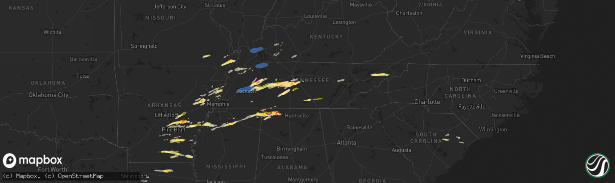
Hail Map in Tennessee on May 20, 2025
The weather event in Tennessee on May 20, 2025 includes Hail, Wind, and Tornado maps. 14 states and 787 cities were impacted and suffered possible damage. The total estimated number of properties impacted is 109,599.
Want more than just the map?
Turn this storm into a full workflow.
- Owner + property data so you know who to knock
- OnDemand branded weather history reports to win the "did we even have hail?" argument
- RoofTrace estimate so reps stop guessing numbers at the door
Bought this map? Upgrade within 7 days and we'll credit the $230. (10-15 min setup call)
Hail
Wind
Tornado
109,599
Estimated number of impacted properties by a 1.00" hail or larger47,728
Estimated number of impacted properties by a 1.75" hail or larger18,844
Estimated number of impacted properties by a 2.50" hail or largerStorm reports in Tennessee
Tennessee
| Date | Description |
|---|---|
| 05/20/20256:46 PM CDT | Estimated ping pong size hail in van buren county. Time estimated from radar. |
| 05/20/20256:44 PM CDT | Several trees down. |
| 05/20/20256:19 PM CDT | Estimated quarter size hail in auburntown. Time estimated from radar. |
| 05/20/20256:15 PM CDT | Report from mping: ping pong ball |
| 05/20/20256:15 PM CDT | Tree blocked johnson hollow road south of interstate 840 near mobleyâs cut road between boston and burwood. Time estimated from radar. |
| 05/20/20256:15 PM CDT | Tree blocked johnson hollow road south of interstate 840 near mobley’s cut road between boston and burwood. Time estimated from radar. |
| 05/20/20256:07 PM CDT | Report from mping: half dollar |
| 05/20/20256:06 PM CDT | Report from mping: ping pong ball |
| 05/20/20255:56 PM CDT | Tree down on ellen drive in goodlettsville. Time estimated from radar. |
| 05/20/20255:55 PM CDT | Large tree down at highway 25 east at cedar grove in cross plains blocking the road. Time estimated from radar. |
| 05/20/20255:51 PM CDT | Tree fell on a vehicle along sr 48 in hickman county. Minor injuries to the driver reported. Time estimated from radar. |
| 05/20/20255:50 PM CDT | Trees and powerlines down in the knob creek and white road areas east of wartrace. Time estimated from radar. |
| 05/20/20255:50 PM CDT | Several trees down. |
| 05/20/20255:50 PM CDT | Tree down on home in the joelton area. Time estimated by radar. |
| 05/20/20255:49 PM CDT | Estimated golf ball size hail near christiana. Time estimated. |
| 05/20/20255:45 PM CDT | Tree down on home on keys branch road near bon aqua. |
| 05/20/20255:41 PM CDT | Report from mping: quarter |
| 05/20/20255:28 PM CDT | Just west of i-24 near sr-76 and hwy-41a. Debris signature on radar. |
| 05/20/20255:25 PM CDT | A nws storm survey team found a ef-0 tornado that occurred in south clarksville. This tornado touched down along e old ashland city rd causing a few trees to lean or fa |
| 05/20/20255:21 PM CDT | Ongoing tornado... Also confirmed by radar. |
| 05/20/20255:20 PM CDT | Trees down. |
| 05/20/20255:19 PM CDT | Downed powerline at florence road & valor drive. Time estimated. |
| 05/20/20255:17 PM CDT | Multiple structures with light damage and dozens of large trees and powerlines down. Time estimated. |
| 05/20/20255:17 PM CDT | Several large trees down across i-24 at mm72 with trees also down across blackman road. Two lanes of i-24 blocked. Time estimated. |
| 05/20/20255:17 PM CDT | Structural damage reported in the blackman area. Time estimated by radar. |
| 05/20/20255:15 PM CDT | 643 customers without power in adams. |
| 05/20/20255:08 PM CDT | A nws storm survey team determined that an ef-0 tornado occurred in north clarksville. This tornado touched down along 101st airborne division rd causing minor tree dam |
| 05/20/20255:02 PM CDT | At the maury county office of emergency management. |
| 05/20/20255:02 PM CDT | Measured 2 inch hail on tom osborne road near boyd butler road. Time estimated from radar. |
| 05/20/20254:59 PM CDT | Report from mping: ping pong ball |
| 05/20/20254:56 PM CDT | Hail a little bigger than quarters reported in columbia. Time estimated from radar. |
| 05/20/20254:55 PM CDT | Ping pong size hail reported at s james campbell blvd and brooksmeade in columbia. |
| 05/20/20254:55 PM CDT | Quarter size hail reported at maury county eoc. Time estimated from radar. |
| 05/20/20254:55 PM CDT | Tree down on powerline in the springville community. Time is radar estimated. |
| 05/20/20254:49 PM CDT | Report from mping: ping pong ball |
| 05/20/20254:49 PM CDT | Report from mping: hen egg |
| 05/20/20254:48 PM CDT | Report from mping: golf ball |
| 05/20/20254:47 PM CDT | Asos station kmkl jackson. |
| 05/20/20254:46 PM CDT | Report from mping: quarter |
| 05/20/20254:46 PM CDT | Trees down in the 2000 block of highway 120 in big rock. Time estimated. |
| 05/20/20254:46 PM CDT | Report from mping: ping pong ball |
| 05/20/20254:45 PM CDT | Report from mping: quarter |
| 05/20/20254:43 PM CDT | A local report indicates 1.00 inch wind near 1 SE Franklin |
| 05/20/20254:42 PM CDT | Measured two inch hail in maplewood subdivision in franklin. Time estimated from radar. |
| 05/20/20254:42 PM CDT | Measured 3 inch hail in franklin. Time estimated from radar. |
| 05/20/20254:42 PM CDT | Estimated quarter size hail on oak meadow drive in franklin. Time estimated from radar. |
| 05/20/20254:41 PM CDT | Quarter size hail at jackson street in mount pleasant. Time estimated from radar. |
| 05/20/20254:41 PM CDT | Quarter to half dollar size hail reported along heathersett drive in dallas downs. |
| 05/20/20254:40 PM CDT | A nws storm survey team surveyed areas west of dover and determined that straight-line wind damage occurred north of highway 79. Numerous trees were found to be downed. |
| 05/20/20254:40 PM CDT | Estimated golf ball size hail in sullivan farms. Time estimated from radar. |
| 05/20/20254:40 PM CDT | Trees and powerlines down at highway 79 and onion hill west of dover. |
| 05/20/20254:40 PM CDT | Quarter size hail on goose creek and lewisburg pike near franklin. Time estimated from radar. |
| 05/20/20254:40 PM CDT | Estimated golf ball size hail near mack hatcher and lewisburg pike near franklin. Time estimated from radar. |
| 05/20/20254:40 PM CDT | Em reports downed trees and structure damage west of dover. Time estimated from radar. |
| 05/20/20254:40 PM CDT | Two inch hail measured in sullivan farms. Time estimated from radar. |
| 05/20/20254:38 PM CDT | Photo received of very large hail on keystone drive south of franklin. Time estimated from radar. |
| 05/20/20254:38 PM CDT | Up to golf ball size hail reported at the public safety center in franklin. Time estimated from radar. |
| 05/20/20254:37 PM CDT | Report from mping: golf ball |
| 05/20/20254:36 PM CDT | Estimated baseball size hail near franklin. Time estimated from radar. |
| 05/20/20254:36 PM CDT | Report from mping: quarter |
| 05/20/20254:35 PM CDT | Video of pingpong ball sized hail and strong wind gusts. |
| 05/20/20254:34 PM CDT | Estimated from picture received at pratt road in thompsons station. |
| 05/20/20254:34 PM CDT | Estimated tennis ball size hail in thompsons station near i-840. Time estimated from radar. |
| 05/20/20254:34 PM CDT | Estimated 1 inch hail at thompson station road and columbia pike. Time estimated from radar. |
| 05/20/20254:30 PM CDT | Several trees down and hail. Hail size unknown. |
| 05/20/20254:21 PM CDT | Golf ball size hail off natchez trace and bending chestnut. Time estimated from radar. |
| 05/20/20254:20 PM CDT | Estimated 2 inch hail in leipers fork. Time estimated from radar. |
| 05/20/20254:18 PM CDT | Tree down on hwy 19 outside of brownsville. Time matched with strong outbound velocity surge on radar. |
| 05/20/20254:18 PM CDT | Photo of significant hail |
| 05/20/20254:17 PM CDT | Trees and powerlines down on ferguson rd in puryear. |
| 05/20/20254:14 PM CDT | Estimated golf ball size hail in primm springs. Time estimated from radar. |
| 05/20/20254:13 PM CDT | Tractor trailer knocked over on snapps ferry rd. Time estimated by radar. |
| 05/20/20254:10 PM CDT | Numerous trees and powerlines down across the city. Time estimated by radar. |
| 05/20/20254:09 PM CDT | Trees down highway 69 n/new boston rd... Cottage grove. |
| 05/20/20254:08 PM CDT | Trees down on blue springs pkwy. Time estimated by radar. |
| 05/20/20254:05 PM CDT | Trees on powerlines. Time estimated by radar. |
| 05/20/20254:03 PM CDT | Trees down on hwy 188 on the gibson/crockett county line in the eaton community. |
| 05/20/20254:00 PM CDT | Large tree downed at the intersection of old memphis road and fayne rd. |
| 05/20/20254:00 PM CDT | Public report of penny to quarter sized hail near elkins rd in centerville. |
| 05/20/20253:56 PM CDT | Two inch hail reported near tn 100 and tn 230 north of centerville. Time estimated from radar. |
| 05/20/20253:56 PM CDT | Golf ball size hail at hickman county high school. |
| 05/20/20253:54 PM CDT | Significant tree damage impacting multiple houses on the west side of martin. Power poles also down. Time is radar estimated. |
| 05/20/20253:54 PM CDT | Estimated 2 inch hail near centerville middle school. Time estimated from radar. |
| 05/20/20253:50 PM CDT | Trees reported down at hickman county high school. Time estimated from radar. |
| 05/20/20253:50 PM CDT | Golf ball size hail reported at hickman county high school. Time estimated from radar. |
| 05/20/20253:47 PM CDT | Trees down on hwy 19 east at old ross road. Time is radar estimated. |
| 05/20/20253:45 PM CDT | Tree down on a house on lee street in martin. Time is radar estimated. |
| 05/20/20253:30 PM CDT | Awos station kucy union city. |
| 05/20/20253:27 PM CDT | Numerous trees down hwy160 near pinebrook. |
| 05/20/20253:25 PM CDT | Multiple trees down across northern perry county... Including along red bank road. Time estimated via radar. |
| 05/20/20253:17 PM CDT | Roof damage noted to the tbi/tn hwy patrol building and additional damage noted at the kirklands warehouse just west of mkl off smith lane. Time is radar estimated. Pos |
| 05/20/20253:15 PM CDT | A brief ef-0 tornado touched down in a wooded area just south of james lawrence road... To the west of smith lane in far southwest jackson... Tn. As the tornado moved n |
| 05/20/20252:59 PM CDT | Tornado viewed on webcam... Also reported by media. |
| 05/20/20252:30 PM CDT | A local report indicates 60 MPH wind near Powell |
| 05/20/20252:28 PM CDT | Trees down on sand ridge bargerton rd. |
| 05/20/20252:10 PM CDT | Power lines down at lookout ave. |
| 05/20/20251:17 PM CDT | Delayed report. Emergency manager reports of damage in chapel hill. Possible tornado. Time estimated from radar. |
| 05/20/202510:30 AM CDT | Emergency manager reports several large trees down... As well as damage to a few sheds. From em and pictures... Everything blown east. |
| 05/20/202510:00 AM CDT | Reported tree down in michie... Tn. Time estimated on radar. |
| 05/20/20259:58 AM CDT | Reported tree down along highway 142 and kimberly ln. Time estimated on radar. |
| 05/20/20259:51 AM CDT | Em reported tree fallen along clifton rd and phillips dr. Time estimated using radar. |
| 05/19/20259:50 PM CDT | Large tree down blocking at least a lane on highway 441 going north near zion hill area. |
| 05/19/20259:42 PM CDT | Several trees down. |
| 05/19/20259:40 PM CDT | A few trees down. |
| 05/19/20259:27 PM CDT | Trees down at maryville housing authority. |
| 05/19/20259:15 PM CDT | Trees down county-wide. |
| 05/19/20259:10 PM CDT | Re-sending report. Measured on an at home anemometer. |
| 05/19/20258:51 PM CDT | Trees down. |
| 05/19/20258:50 PM CDT | Several trees down. |
| 05/19/20258:45 PM CDT | Several trees down. |
| 05/19/20258:40 PM CDT | Trees reported down in scott county. |
| 05/19/20258:31 PM CDT | Damage reported at vandever road and highway 127. Time estimated from radar. |
| 05/19/20258:05 PM CDT | Structure damage reported on rhea road. Time estimated. |
| 05/19/20258:00 PM CDT | Golf ball size hail on burgess road. Time estimated. |
| 05/19/20257:40 PM CDT | Multiple trees down across western and central putnam county. Time estimated. |
| 05/19/20257:40 PM CDT | Correct previous report from 1 nnw crossville. Multiple trees down across western and central putnam county. Time estimated. |
| 05/19/20257:39 PM CDT | Trees down and nickel size hail. |
| 05/19/20257:37 PM CDT | A nws storm survey team determined that an ef-1 tornado occurred in southern cumberland county. This tornado touched down along vandever rd near new era causing timber |
| 05/19/20257:01 PM CDT | Quarter-size hail in quebeck. |
All States Impacted by Hail Map on May 20, 2025
Cities Impacted by Hail Map on May 20, 2025
- Ostrander, MN
- Wykoff, MN
- Le Roy, MN
- Spring Valley, MN
- Carrollton, TX
- Plano, TX
- Garland, TX
- Addison, TX
- Grand Prairie, TX
- Dallas, TX
- Bedford, TX
- Coppell, TX
- Grapevine, TX
- Euless, TX
- Arlington, TX
- Hurst, TX
- Naval Air Station Jrb, TX
- North Richland Hills, TX
- Irving, TX
- Haltom City, TX
- Fort Worth, TX
- Richardson, TX
- Colleyville, TX
- Crystal City, TX
- Cotulla, TX
- Dilley, TX
- Pearsall, TX
- Asherton, TX
- Charlotte, TX
- Floresville, TX
- Jourdanton, TX
- Stockdale, TX
- Encinal, TX
- Pleasanton, TX
- Bethel Springs, TN
- Selmer, TN
- Adamsville, TN
- Gillett, TX
- Waterloo, AL
- Jacksonville, IL
- Winchester, IL
- Murrayville, IL
- Sheridan, AR
- Alexander, IL
- Jefferson, AR
- Redfield, AR
- White Hall, AR
- Woodson, IL
- Ashland, IL
- Sherrill, AR
- England, AR
- Tucker, AR
- Crab Orchard, TN
- Rockwood, TN
- Oakdale, TN
- Lonoke, AR
- Carlisle, AR
- Batesville, MS
- Pleasant Plains, IL
- Harriman, TN
- Gable, SC
- Carthage, AR
- Franklin, IL
- New Berlin, IL
- Grandin, MO
- Poplar Bluff, MO
- Parma, MO
- Lilbourn, MO
- Catron, MO
- Tallula, IL
- Hazen, AR
- De Valls Bluff, AR
- Waverly, IL
- Biscoe, AR
- McCrory, AR
- Stuttgart, AR
- Wabbaseka, AR
- Humnoke, AR
- Humphrey, AR
- Pulaski, TN
- New Zion, SC
- Sardis, MS
- Rison, AR
- Roodhouse, IL
- Loami, IL
- Oxford, MS
- Abbeville, MS
- Springfield, IL
- Marked Tree, AR
- Wynne, AR
- Turbeville, SC
- Petersburg, IL
- Altheimer, AR
- Fordyce, AR
- Huron, TN
- Lexington, TN
- Beech Bluff, TN
- Lake City, SC
- Cades, SC
- Wildersville, TN
- Williamsville, MO
- Como, MS
- Tyronza, AR
- Potts Camp, MS
- Darden, TN
- Parsons, TN
- New Edinburg, AR
- Pamplico, SC
- Sikeston, MO
- Lepanto, AR
- Dyess, AR
- Kingsland, AR
- New Madrid, MO
- Chatham, IL
- Waterford, MS
- Holly Springs, MS
- Cantrall, IL
- Caraway, AR
- Manila, AR
- Matthews, MO
- Holladay, TN
- Thaxton, MS
- Etta, MS
- Sherman, IL
- Almyra, AR
- Riverton, IL
- Dawson, IL
- Pekin, IL
- Peoria, IL
- East Peoria, IL
- Creve Coeur, IL
- Charleston, MO
- Louann, AR
- Wilmar, AR
- Casscoe, AR
- Star City, AR
- Parkin, AR
- Colt, AR
- Tiptonville, TN
- Ridgely, TN
- Gresham, SC
- Hayti, MO
- Williamsville, IL
- Athens, IL
- Elkhart, IL
- Johnsonville, SC
- Bertrand, MO
- Osceola, AR
- Centerville, TN
- Sugar Tree, TN
- Lobelville, TN
- Waverly, TN
- Linden, TN
- Buffalo, IL
- Grady, AR
- Dumas, AR
- Hampton, AR
- Forrest City, AR
- Joiner, AR
- Wilson, AR
- East Prairie, MO
- Ringgold, LA
- De Witt, AR
- Crocketts Bluff, AR
- Keiser, AR
- Mansfield, LA
- Roe, AR
- Myrtle, MS
- Dubach, LA
- Timmonsville, SC
- Hornbeak, TN
- Paxton, IL
- Ludlow, IL
- Rantoul, IL
- Mount Pulaski, IL
- Illiopolis, IL
- Jersey, AR
- Hermitage, AR
- Banks, AR
- Coushatta, LA
- Wickliffe, KY
- Barlow, KY
- Lincoln, IL
- Beason, IL
- Gibsland, LA
- Dubberly, LA
- Saint Charles, AR
- Henning, TN
- Union City, TN
- Rives, TN
- Troy, TN
- Latham, IL
- Jamestown, LA
- Hurricane Mills, TN
- Only, TN
- New Albany, MS
- Blue Mountain, MS
- Hemingway, SC
- Heflin, LA
- Warrensburg, IL
- Maroa, IL
- Nunnelly, TN
- Trimble, TN
- Kenton, TN
- Lynchburg, SC
- Olanta, SC
- Winchester, TN
- Estill Springs, TN
- Tullahoma, TN
- Holly Grove, AR
- Ethel, AR
- Dumas, MS
- Martin, TN
- Sharon, TN
- Poplar Grove, AR
- Marvell, AR
- Santa Fe, TN
- Williamsport, TN
- Pickens, AR
- Morristown, TN
- Booneville, MS
- Ripley, MS
- Chestnut, IL
- Luxora, AR
- Decatur, IL
- Rienzi, MS
- Waynesville, IL
- Kenney, IL
- Atlanta, IL
- Clinton, IL
- Bon Aqua, TN
- Lyles, TN
- Mohawk, TN
- Clarendon, AR
- Elaine, AR
- Lexa, AR
- Helena, AR
- Monticello, AR
- Decherd, TN
- Jackson, TN
- Midway, TN
- Fountain Hill, AR
- Hamburg, AR
- Hillsboro, TN
- Russellville, TN
- Bybee, TN
- Cedar Grove, TN
- Downsville, LA
- Duck River, TN
- Ashland, LA
- Saline, LA
- Choudrant, LA
- Farmerville, LA
- Whitesburg, TN
- Primm Springs, TN
- South Fulton, TN
- Oreana, IL
- Franklin, TN
- Baldwyn, MS
- Mosheim, TN
- Greeneville, TN
- Paducah, KY
- Smithland, KY
- Ledbetter, KY
- Brookport, IL
- Calvert City, KY
- Eddyville, KY
- Kuttawa, KY
- Grand Rivers, KY
- Tiline, KY
- Marion, KY
- Gilbertsville, KY
- Benton, KY
- Symsonia, KY
- Dickson, TN
- Fairview, TN
- Iuka, MS
- Friars Point, MS
- Coahoma, MS
- Dundee, MS
- Clarksdale, MS
- Palmersville, TN
- Dresden, TN
- Cherry Valley, AR
- Harrisburg, AR
- Trumann, AR
- Huntingdon, TN
- Yuma, TN
- Paris, TN
- Argenta, IL
- Cisco, IL
- Loda, IL
- Hickory Ridge, AR
- Tishomingo, MS
- Goldonna, LA
- Earle, AR
- Burnsville, MS
- Millington, TN
- Tillar, AR
- Drummonds, TN
- Crossett, AR
- Glen, MS
- Cherokee, AL
- Sterlington, LA
- Weldon, IL
- De Land, IL
- Monticello, IL
- Dodson, LA
- Winnfield, LA
- Columbia, TN
- Puryear, TN
- Hazel, KY
- Thompsons Station, TN
- Murray, KY
- New Concord, KY
- Buchanan, TN
- Spring Hill, TN
- Buena Vista, TN
- Westport, TN
- Sledge, MS
- Marks, MS
- Cottage Grove, TN
- Mahomet, IL
- Mansfield, IL
- White Heath, IL
- Montrose, AR
- Castor, LA
- Camden, TN
- Gibson City, IL
- Afton, TN
- Foosland, IL
- Lawrenceburg, TN
- Summertown, TN
- Fisher, IL
- Scotts Hill, TN
- Watson, AR
- Pelham, TN
- Tracy City, TN
- Dover, TN
- Monteagle, TN
- Dewey, IL
- Buckley, IL
- Ogden, IL
- Saint Joseph, IL
- Homer, IL
- Fithian, IL
- Seymour, IL
- College Grove, TN
- Champaign, IL
- Arrington, TN
- Nolensville, TN
- Sidney, IL
- Penfield, IL
- Gifford, IL
- Lebanon, VA
- Limestone, TN
- Chuckey, TN
- Mount Pleasant, TN
- Brentwood, TN
- Dayton, TX
- Liberty, TX
- Urbana, IL
- Dewitt, IL
- Monroe, LA
- Palmer, TN
- Whitwell, TN
- Armstrong, IL
- Telford, TN
- Jonesborough, TN
- Dunlap, TN
- Brownsville, TN
- Bells, TN
- Denmark, TN
- Oakfield, TN
- Medina, TN
- Culleoka, TN
- Tuscumbia, AL
- Florence, AL
- Muscle Shoals, AL
- Sheffield, AL
- Hopkinsville, KY
- Rankin, IL
- New Johnsonville, TN
- Lyon, MS
- Thomasboro, IL
- Antioch, TN
- Nashville, TN
- Campti, LA
- Madisonville, KY
- Earlington, KY
- Dawson Springs, KY
- Portland, AR
- Killen, AL
- Olla, LA
- Sikes, LA
- Bulls Gap, TN
- Clarksville, TN
- Smyrna, TN
- Murfreesboro, TN
- Saybrook, IL
- Bellflower, IL
- Potomac, IL
- Collison, IL
- Mortons Gap, KY
- White Plains, KY
- Eudora, AR
- Lake Village, AR
- Elkton, KY
- Russellville, AL
- Crenshaw, MS
- Leighton, AL
- Devers, TX
- Savoy, IL
- Greenville, KY
- Hull, TX
- Beulah, MS
- Rockvale, TN
- La Vergne, TN
- Town Creek, AL
- Danville, IL
- Rogersville, AL
- Chapel Hill, TN
- Lewisburg, TN
- Auburn, KY
- Woodburn, KY
- Rossville, IL
- Alvin, IL
- Henning, IL
- Eagleville, TN
- Iron City, TN
- Saint Joseph, TN
- Central City, KY
- Bremen, KY
- Courtland, AL
- Red Bay, AL
- Franklin, KY
- Lambert, MS
- McEwen, TN
- Unionville, TN
- Athens, AL
- Lascassas, TN
- Auburntown, TN
- Milton, TN
- Williamsport, IN
- Beaumont, TX
- Hollandale, MS
- Bismarck, IL
- Bowling Green, KY
- Greenville, MS
- Rockfield, KY
- Russellville, KY
- Alvaton, KY
- Boyle, MS
- Oakwood, IL
- Bondville, IL
- Bell Buckle, TN
- University, MS
- Taylor, MS
- Hillsboro, AL
- Pope, MS
- Courtland, MS
- Christiana, TN
- Elkmont, AL
- West Lebanon, IN
- Readyville, TN
- Kingston Springs, TN
- Kelly, LA
- Shaw, MS
- Doddsville, MS
- Ruleville, MS
- Cleveland, MS
- Gaffney, SC
- Cowpens, SC
- Graham, KY
- Philo, IL
- Soddy Daisy, TN
- Birchwood, TN
- Sale Creek, TN
- Bradyville, TN
- Beechgrove, TN
- Woodbury, TN
- Burns, TN
- Chatham, MS
- Warren, TX
- Water Valley, MS
- Liberty, TN
- Dowelltown, TN
- Adams, TN
- Smithville, TN
- Decatur, TN
- Glen Allan, MS
- Tullos, LA
- Perrysville, IN
- Covington, IN
- Tanner, AL
- Madison, AL
- Athens, TN
- Calhoun, TN
- Cape Girardeau, MO
- Rolling Fork, MS
- Anguilla, MS
- Veedersburg, IN
- Scottsville, KY
- Adolphus, KY
- Lebanon, TN
- Watertown, TN
- Shelbyville, TN
- Morrison, TN
- Mcminnville, TN
- Schlater, MS
- Belzoni, MS
- Pontotoc, MS
- Paris, MS
- Georgetown, LA
- Harvest, AL
- Huntsville, AL
- Manchester, TN
- Fairmount, IL
- Atlanta, LA
- Austin, KY
- Fountain Run, KY
- Rock Island, TN
- Silver City, MS
- Louise, MS
- Trout, LA
- Elliott, IL
- Cissna Park, IL
- Banner, MS
- Greenwood, MS
- Moulton, AL
- Danville, AL
- Wartrace, TN
- Spencer, TN
- Doyle, TN
- Sparta, TN
- Wingate, IN
- Randolph, MS
- Decatur, AL
- Hartselle, AL
- Charlotte, TN
- Mellott, IN
- Waynetown, IN
- Hillsboro, IN
- Glasgow, KY
- Etoile, KY
- Pegram, TN
- Morgantown, KY
- Caneyville, KY
- Quebeck, TN
- Sharon, SC
- Hickory Grove, SC
- Jena, LA
- Owens Cross Roads, AL
- Brownsboro, AL
- Gurley, AL
- Crossville, TN
- Pollock, LA
- Hamilton, AL
- Crawfordsville, IN
- Dry Prong, LA
- Somerville, AL
- Jonesville, LA
- Tremont, MS
- New Richmond, IN
- York, SC
- Millwood, KY
- Leitchfield, KY
- Vina, AL
- Alexandria, TN
- New Market, AL
- Walling, TN
- Trenton, AL
- Hollytree, AL
- Woodville, AL
- Valhermoso Springs, AL
- Laceys Spring, AL
- Tupelo, MS
- Shannon, MS
- Martinsville, IN
- Cloverdale, IN
- Monrovia, IN
- Trinity, AL
- Hackleburg, AL
- Newman, IL
- Allerton, IL
- Lester, AL
- Mooresville, IN
- Linden, IN
- Grandview, TN
- Plantersville, MS
- Goodman, MS
- Pickens, MS
- Chrisman, IL
- Yazoo City, MS
- Stilesville, IN
- Quincy, IN
- Graysville, TN
- Darlington, IN
- Nettleton, MS
- Scottsboro, AL
- Golden, MS
- Fulton, MS
- Stevenson, AL
- Hollywood, AL
- Benton, MS
- Hodges, AL
- Fackler, AL
- Frankfort, IN
- Mantachie, MS
- Camby, IN
- Lena, LA
- Colfax, LA
- Cloutierville, LA
- Paris, IL
- West Union, IL
- Amory, MS
- Flat Rock, AL
- Pisgah, AL
- New Hope, AL
- Grant, AL
- Milford, IL
- Watseka, IL
- Hoopeston, IL
- Sheldon, IL
- Wellington, IL
- Langston, AL
- Stockland, IL
- Ambia, IN
- Fowler, IN
- Royal, IL
- Boswell, IN
- Attica, IN
- Higdon, AL
- Smithville, MS
- Dayton, TN
- Mount Carmel, IL
- Saint Francisville, IL
- Indianapolis, IN
- Greenwood, IN
- Rising Fawn, GA
- Okolona, MS
- Brooklyn, IN
- Guild, TN
- Pikeville, TN
- Bryant, AL
- Trenton, GA
- Chattanooga, TN
- Signal Mountain, TN
- Section, AL
- Monterey, LA
- Greenwood Springs, MS
- Detroit, AL
- Bear Creek, AL
- Bentonia, MS
- Mooreville, MS
- Houlka, MS
- Pineville, LA
- Vaughan, MS
- Dutton, AL
- Terre Haute, IN
- Camden, MS
- Sallis, MS
- Vidalia, LA
- Tinsley, MS
- Satartia, MS
- Westville, IL
- Rosedale, IN
- Brazil, IN
- Alexandria, LA
- Boyce, LA
- Canton, MS
- West Terre Haute, IN
- West York, IL
- Fairland, IN
- Fountaintown, IN
- Shelbyville, IN
- Carthage, MS
- Whiteland, IN
- Center Point, LA
- Deville, LA
- Effie, LA
- Double Springs, AL
- Houston, AL
- Madison, MS
- Flora, MS
- Georgetown, IL
- Morristown, IN
- Eva, TN
- Carbon Hill, AL
- Townley, AL
- Big Sandy, TN
- Marksville, LA
- Oakman, AL
- Jasper, AL
- Lena, MS
- Brandon, MS
- Oak Ridge, TN
- Kingston, TN
- Lenoir City, TN
- Farragut, TN
- Knoxville, TN
- Clinton, TN
- Powell, TN
- Seymour, TN
- Sevierville, TN
- Morton, MS
- Pelahatchie, MS
- Cullman, AL
- Hanceville, AL
- Parrish, AL
- Moreauville, LA
- Forest Hill, LA
- Forest, MS
- Oneonta, AL
- Springville, AL
- Steele, AL
- Lecompte, LA
- Toney, AL
- Woodville, MS
- Angola, LA
- Saint Francisville, LA
- Pineville, KY
- Arjay, KY
- Kettle Island, KY
- Hulen, KY
- Stoney Fork, KY
- Miracle, KY
- Pathfork, KY
- Coldiron, KY
- Bledsoe, KY
- Wallins Creek, KY
- Dayhoit, KY
- Loyall, KY
- Harlan, KY
- Putney, KY
- Baxter, KY
- Totz, KY
- Ages Brookside, KY
- Evarts, KY
- Gordon, KY
- Big Laurel, KY
- Closplint, KY
- Cumberland, KY
- Benham, KY
- Lynch, KY
- Appalachia, VA
- Cheneyville, LA
- Ashville, AL
- Ragland, AL
- Ohatchee, AL
- Walnut Grove, MS
- Anniston, AL
- Heflin, AL
- Ranburne, AL
- Batchelor, LA
- Lettsworth, LA
- Woodworth, LA
- Ball, LA
- Sharpsburg, GA
- Fayetteville, GA
- Palmetto, GA
- Tyrone, GA
- Newnan, GA
- Whitesburg, GA
- Jonesboro, GA
- Peachtree City, GA
- Hampton, GA
- Riverdale, GA
- Forsyth, IL
- Locust Grove, GA
- Jenkinsburg, GA
- Jackson, GA
- Effingham, SC
- Forest Park, GA
- Rex, GA
- Morrow, GA
- Atlanta, GA
- Fairburn, GA
- Stockbridge, GA
- Bonaire, GA
- Kathleen, GA
- Bargersville, IN
- Franklin, IN
- West Newton, IN
- Greencastle, IN
- Dennis, MS
- Paint Rock, AL


