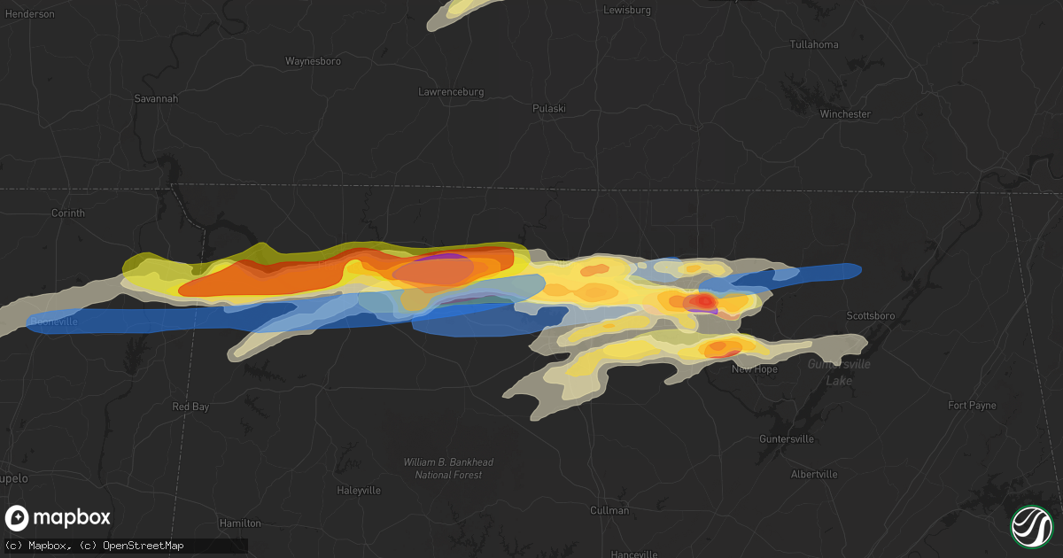
Hail Map in Athens, AL on May 20, 2025
Get this storm
May 20 map
$229
one time, instant access
Download today. No call, no setup
Keep the $229
Bought the map and want the full workflow? Apply the entire $229 to a subscription within 7 days. None of it is wasted.
Every map, not just this one
This buys you this map. Subscription and you get every map we run, in the markets you choose from a few cities to whole states to nationwide. Plus real-time alerts the moment a storm fires.
Contact data
Name, contact info, occupancy, even credit band for addresses in the footprint. You go from where it hit to who to call.
Become the source they trust
Unlimited branding weather history reports on demand. You already have the documented answer ready for the property owner, and you are the one who showed up with it.
Property data and RoofTrace estimates
Pull up any address you have got, its value and the exact code rules for that jurisdiction, straight from One Click Code. Then RoofTrace estimates the squares, pitch, and roof value, priced the way you price.
Storm reports in Athens, AL
Athens, AL
| Date | Description |
|---|---|
| 05/20/20256:59 PM CDT | Report from mping: hen egg |
| 05/20/20256:41 PM CDT | Report from mping: golf ball |
| 05/20/20256:39 PM CDT | Report from mping: half dollar |
| 05/20/20256:12 PM CDT | Several trees and powerlines down along sanderfer rd. Time estimated from radar. |
| 05/20/20256:12 PM CDT | Tree down on a house behind the staples in athens. Time estimated from radar. |
| 05/20/20256:12 PM CDT | Several trees and powerlines down alon |
| 05/20/20256:10 PM CDT | Multiple downed power poles and poles snapped on lucas ferry rd just south of hwy 72. |
| 05/20/20256:09 PM CDT | Power lines down along grisby lane and brownsferry roads. Time estimated from radar. |
| 05/20/20256:09 PM CDT | Tree down on hine street south. Time estimated from radar. |
| 05/20/20256:04 PM CDT | Tree down at hwy 72 and glaze rd. Timer estimated from radar. |
| 05/20/20255:42 PM CDT | Trees and power lines down along little elk road. Time estimated from radar. |
All States Impacted by Hail Map on May 20, 2025
All Cities Impacted by Hail Map on May 20, 2025
- Ostrander, MN
- Wykoff, MN
- Le Roy, MN
- Spring Valley, MN
- Carrollton, TX
- Plano, TX
- Garland, TX
- Addison, TX
- Grand Prairie, TX
- Dallas, TX
- Bedford, TX
- Coppell, TX
- Grapevine, TX
- Euless, TX
- Arlington, TX
- Hurst, TX
- Naval Air Station Jrb, TX
- North Richland Hills, TX
- Irving, TX
- Haltom City, TX
- Fort Worth, TX
- Richardson, TX
- Colleyville, TX
- Crystal City, TX
- Cotulla, TX
- Dilley, TX
- Pearsall, TX
- Asherton, TX
- Charlotte, TX
- Floresville, TX
- Jourdanton, TX
- Stockdale, TX
- Encinal, TX
- Pleasanton, TX
- Bethel Springs, TN
- Selmer, TN
- Adamsville, TN
- Gillett, TX
- Waterloo, AL
- Jacksonville, IL
- Winchester, IL
- Murrayville, IL
- Sheridan, AR
- Alexander, IL
- Jefferson, AR
- Redfield, AR
- White Hall, AR
- Woodson, IL
- Ashland, IL
- Sherrill, AR
- England, AR
- Tucker, AR
- Crab Orchard, TN
- Rockwood, TN
- Oakdale, TN
- Lonoke, AR
- Carlisle, AR
- Batesville, MS
- Pleasant Plains, IL
- Harriman, TN
- Gable, SC
- Carthage, AR
- Franklin, IL
- New Berlin, IL
- Grandin, MO
- Poplar Bluff, MO
- Parma, MO
- Lilbourn, MO
- Catron, MO
- Tallula, IL
- Hazen, AR
- De Valls Bluff, AR
- Waverly, IL
- Biscoe, AR
- McCrory, AR
- Stuttgart, AR
- Wabbaseka, AR
- Humnoke, AR
- Humphrey, AR
- Pulaski, TN
- New Zion, SC
- Sardis, MS
- Rison, AR
- Roodhouse, IL
- Loami, IL
- Oxford, MS
- Abbeville, MS
- Springfield, IL
- Marked Tree, AR
- Wynne, AR
- Turbeville, SC
- Petersburg, IL
- Altheimer, AR
- Fordyce, AR
- Huron, TN
- Lexington, TN
- Beech Bluff, TN
- Lake City, SC
- Cades, SC
- Wildersville, TN
- Williamsville, MO
- Como, MS
- Tyronza, AR
- Potts Camp, MS
- Darden, TN
- Parsons, TN
- New Edinburg, AR
- Pamplico, SC
- Sikeston, MO
- Lepanto, AR
- Dyess, AR
- Kingsland, AR
- New Madrid, MO
- Chatham, IL
- Waterford, MS
- Holly Springs, MS
- Cantrall, IL
- Caraway, AR
- Manila, AR
- Matthews, MO
- Holladay, TN
- Thaxton, MS
- Etta, MS
- Sherman, IL
- Almyra, AR
- Riverton, IL
- Dawson, IL
- Pekin, IL
- Peoria, IL
- East Peoria, IL
- Creve Coeur, IL
- Charleston, MO
- Louann, AR
- Wilmar, AR
- Casscoe, AR
- Star City, AR
- Parkin, AR
- Colt, AR
- Tiptonville, TN
- Ridgely, TN
- Gresham, SC
- Hayti, MO
- Williamsville, IL
- Athens, IL
- Elkhart, IL
- Johnsonville, SC
- Bertrand, MO
- Osceola, AR
- Centerville, TN
- Sugar Tree, TN
- Lobelville, TN
- Waverly, TN
- Linden, TN
- Buffalo, IL
- Grady, AR
- Dumas, AR
- Hampton, AR
- Forrest City, AR
- Joiner, AR
- Wilson, AR
- East Prairie, MO
- Ringgold, LA
- De Witt, AR
- Crocketts Bluff, AR
- Keiser, AR
- Mansfield, LA
- Roe, AR
- Myrtle, MS
- Dubach, LA
- Timmonsville, SC
- Hornbeak, TN
- Paxton, IL
- Ludlow, IL
- Rantoul, IL
- Mount Pulaski, IL
- Illiopolis, IL
- Jersey, AR
- Hermitage, AR
- Banks, AR
- Coushatta, LA
- Wickliffe, KY
- Barlow, KY
- Lincoln, IL
- Beason, IL
- Gibsland, LA
- Dubberly, LA
- Saint Charles, AR
- Henning, TN
- Union City, TN
- Rives, TN
- Troy, TN
- Latham, IL
- Jamestown, LA
- Hurricane Mills, TN
- Only, TN
- New Albany, MS
- Blue Mountain, MS
- Hemingway, SC
- Heflin, LA
- Warrensburg, IL
- Maroa, IL
- Nunnelly, TN
- Trimble, TN
- Kenton, TN
- Lynchburg, SC
- Olanta, SC
- Winchester, TN
- Estill Springs, TN
- Tullahoma, TN
- Holly Grove, AR
- Ethel, AR
- Dumas, MS
- Martin, TN
- Sharon, TN
- Poplar Grove, AR
- Marvell, AR
- Santa Fe, TN
- Williamsport, TN
- Pickens, AR
- Morristown, TN
- Booneville, MS
- Ripley, MS
- Chestnut, IL
- Luxora, AR
- Decatur, IL
- Rienzi, MS
- Waynesville, IL
- Kenney, IL
- Atlanta, IL
- Clinton, IL
- Bon Aqua, TN
- Lyles, TN
- Mohawk, TN
- Clarendon, AR
- Elaine, AR
- Lexa, AR
- Helena, AR
- Monticello, AR
- Decherd, TN
- Jackson, TN
- Midway, TN
- Fountain Hill, AR
- Hamburg, AR
- Hillsboro, TN
- Russellville, TN
- Bybee, TN
- Cedar Grove, TN
- Downsville, LA
- Duck River, TN
- Ashland, LA
- Saline, LA
- Choudrant, LA
- Farmerville, LA
- Whitesburg, TN
- Primm Springs, TN
- South Fulton, TN
- Oreana, IL
- Franklin, TN
- Baldwyn, MS
- Mosheim, TN
- Greeneville, TN
- Paducah, KY
- Smithland, KY
- Ledbetter, KY
- Brookport, IL
- Calvert City, KY
- Eddyville, KY
- Kuttawa, KY
- Grand Rivers, KY
- Tiline, KY
- Marion, KY
- Gilbertsville, KY
- Benton, KY
- Symsonia, KY
- Dickson, TN
- Fairview, TN
- Iuka, MS
- Friars Point, MS
- Coahoma, MS
- Dundee, MS
- Clarksdale, MS
- Palmersville, TN
- Dresden, TN
- Cherry Valley, AR
- Harrisburg, AR
- Trumann, AR
- Huntingdon, TN
- Yuma, TN
- Paris, TN
- Argenta, IL
- Cisco, IL
- Loda, IL
- Hickory Ridge, AR
- Tishomingo, MS
- Goldonna, LA
- Earle, AR
- Burnsville, MS
- Millington, TN
- Tillar, AR
- Drummonds, TN
- Crossett, AR
- Glen, MS
- Cherokee, AL
- Sterlington, LA
- Weldon, IL
- De Land, IL
- Monticello, IL
- Dodson, LA
- Winnfield, LA
- Columbia, TN
- Puryear, TN
- Hazel, KY
- Thompsons Station, TN
- Murray, KY
- New Concord, KY
- Buchanan, TN
- Spring Hill, TN
- Buena Vista, TN
- Westport, TN
- Sledge, MS
- Marks, MS
- Cottage Grove, TN
- Mahomet, IL
- Mansfield, IL
- White Heath, IL
- Montrose, AR
- Castor, LA
- Camden, TN
- Gibson City, IL
- Afton, TN
- Foosland, IL
- Lawrenceburg, TN
- Summertown, TN
- Fisher, IL
- Scotts Hill, TN
- Watson, AR
- Pelham, TN
- Tracy City, TN
- Dover, TN
- Monteagle, TN
- Dewey, IL
- Buckley, IL
- Ogden, IL
- Saint Joseph, IL
- Homer, IL
- Fithian, IL
- Seymour, IL
- College Grove, TN
- Champaign, IL
- Arrington, TN
- Nolensville, TN
- Sidney, IL
- Penfield, IL
- Gifford, IL
- Lebanon, VA
- Limestone, TN
- Chuckey, TN
- Mount Pleasant, TN
- Brentwood, TN
- Dayton, TX
- Liberty, TX
- Urbana, IL
- Dewitt, IL
- Monroe, LA
- Palmer, TN
- Whitwell, TN
- Armstrong, IL
- Telford, TN
- Jonesborough, TN
- Dunlap, TN
- Brownsville, TN
- Bells, TN
- Denmark, TN
- Oakfield, TN
- Medina, TN
- Culleoka, TN
- Tuscumbia, AL
- Florence, AL
- Muscle Shoals, AL
- Sheffield, AL
- Hopkinsville, KY
- Rankin, IL
- New Johnsonville, TN
- Lyon, MS
- Thomasboro, IL
- Antioch, TN
- Nashville, TN
- Campti, LA
- Madisonville, KY
- Earlington, KY
- Dawson Springs, KY
- Portland, AR
- Killen, AL
- Olla, LA
- Sikes, LA
- Bulls Gap, TN
- Clarksville, TN
- Smyrna, TN
- Murfreesboro, TN
- Saybrook, IL
- Bellflower, IL
- Potomac, IL
- Collison, IL
- Mortons Gap, KY
- White Plains, KY
- Eudora, AR
- Lake Village, AR
- Elkton, KY
- Russellville, AL
- Crenshaw, MS
- Leighton, AL
- Devers, TX
- Savoy, IL
- Greenville, KY
- Hull, TX
- Beulah, MS
- Rockvale, TN
- La Vergne, TN
- Town Creek, AL
- Danville, IL
- Rogersville, AL
- Chapel Hill, TN
- Lewisburg, TN
- Auburn, KY
- Woodburn, KY
- Rossville, IL
- Alvin, IL
- Henning, IL
- Eagleville, TN
- Iron City, TN
- Saint Joseph, TN
- Central City, KY
- Bremen, KY
- Courtland, AL
- Red Bay, AL
- Franklin, KY
- Lambert, MS
- McEwen, TN
- Unionville, TN
- Athens, AL
- Lascassas, TN
- Auburntown, TN
- Milton, TN
- Williamsport, IN
- Beaumont, TX
- Hollandale, MS
- Bismarck, IL
- Bowling Green, KY
- Greenville, MS
- Rockfield, KY
- Russellville, KY
- Alvaton, KY
- Boyle, MS
- Oakwood, IL
- Bondville, IL
- Bell Buckle, TN
- University, MS
- Taylor, MS
- Hillsboro, AL
- Pope, MS
- Courtland, MS
- Christiana, TN
- Elkmont, AL
- West Lebanon, IN
- Readyville, TN
- Kingston Springs, TN
- Kelly, LA
- Shaw, MS
- Doddsville, MS
- Ruleville, MS
- Cleveland, MS
- Gaffney, SC
- Cowpens, SC
- Graham, KY
- Philo, IL
- Soddy Daisy, TN
- Birchwood, TN
- Sale Creek, TN
- Bradyville, TN
- Beechgrove, TN
- Woodbury, TN
- Burns, TN
- Chatham, MS
- Warren, TX
- Water Valley, MS
- Liberty, TN
- Dowelltown, TN
- Adams, TN
- Smithville, TN
- Decatur, TN
- Glen Allan, MS
- Tullos, LA
- Perrysville, IN
- Covington, IN
- Tanner, AL
- Madison, AL
- Athens, TN
- Calhoun, TN
- Cape Girardeau, MO
- Rolling Fork, MS
- Anguilla, MS
- Veedersburg, IN
- Scottsville, KY
- Adolphus, KY
- Lebanon, TN
- Watertown, TN
- Shelbyville, TN
- Morrison, TN
- Mcminnville, TN
- Schlater, MS
- Belzoni, MS
- Pontotoc, MS
- Paris, MS
- Georgetown, LA
- Harvest, AL
- Huntsville, AL
- Manchester, TN
- Fairmount, IL
- Atlanta, LA
- Austin, KY
- Fountain Run, KY
- Rock Island, TN
- Silver City, MS
- Louise, MS
- Trout, LA
- Elliott, IL
- Cissna Park, IL
- Banner, MS
- Greenwood, MS
- Moulton, AL
- Danville, AL
- Wartrace, TN
- Spencer, TN
- Doyle, TN
- Sparta, TN
- Wingate, IN
- Randolph, MS
- Decatur, AL
- Hartselle, AL
- Charlotte, TN
- Mellott, IN
- Waynetown, IN
- Hillsboro, IN
- Glasgow, KY
- Etoile, KY
- Pegram, TN
- Morgantown, KY
- Caneyville, KY
- Quebeck, TN
- Sharon, SC
- Hickory Grove, SC
- Jena, LA
- Owens Cross Roads, AL
- Brownsboro, AL
- Gurley, AL
- Crossville, TN
- Pollock, LA
- Hamilton, AL
- Crawfordsville, IN
- Dry Prong, LA
- Somerville, AL
- Jonesville, LA
- Tremont, MS
- New Richmond, IN
- York, SC
- Millwood, KY
- Leitchfield, KY
- Vina, AL
- Alexandria, TN
- New Market, AL
- Walling, TN
- Trenton, AL
- Hollytree, AL
- Woodville, AL
- Valhermoso Springs, AL
- Laceys Spring, AL
- Tupelo, MS
- Shannon, MS
- Martinsville, IN
- Cloverdale, IN
- Monrovia, IN
- Trinity, AL
- Hackleburg, AL
- Newman, IL
- Allerton, IL
- Lester, AL
- Mooresville, IN
- Linden, IN
- Grandview, TN
- Plantersville, MS
- Goodman, MS
- Pickens, MS
- Chrisman, IL
- Yazoo City, MS
- Stilesville, IN
- Quincy, IN
- Graysville, TN
- Darlington, IN
- Nettleton, MS
- Scottsboro, AL
- Golden, MS
- Fulton, MS
- Stevenson, AL
- Hollywood, AL
- Benton, MS
- Hodges, AL
- Fackler, AL
- Frankfort, IN
- Mantachie, MS
- Camby, IN
- Lena, LA
- Colfax, LA
- Cloutierville, LA
- Paris, IL
- West Union, IL
- Amory, MS
- Flat Rock, AL
- Pisgah, AL
- New Hope, AL
- Grant, AL
- Milford, IL
- Watseka, IL
- Hoopeston, IL
- Sheldon, IL
- Wellington, IL
- Langston, AL
- Stockland, IL
- Ambia, IN
- Fowler, IN
- Royal, IL
- Boswell, IN
- Attica, IN
- Higdon, AL
- Smithville, MS
- Dayton, TN
- Mount Carmel, IL
- Saint Francisville, IL
- Indianapolis, IN
- Greenwood, IN
- Rising Fawn, GA
- Okolona, MS
- Brooklyn, IN
- Guild, TN
- Pikeville, TN
- Bryant, AL
- Trenton, GA
- Chattanooga, TN
- Signal Mountain, TN
- Section, AL
- Monterey, LA
- Greenwood Springs, MS
- Detroit, AL
- Bear Creek, AL
- Bentonia, MS
- Mooreville, MS
- Houlka, MS
- Pineville, LA
- Vaughan, MS
- Dutton, AL
- Terre Haute, IN
- Camden, MS
- Sallis, MS
- Vidalia, LA
- Tinsley, MS
- Satartia, MS
- Westville, IL
- Rosedale, IN
- Brazil, IN
- Alexandria, LA
- Boyce, LA
- Canton, MS
- West Terre Haute, IN
- West York, IL
- Fairland, IN
- Fountaintown, IN
- Shelbyville, IN
- Carthage, MS
- Whiteland, IN
- Center Point, LA
- Deville, LA
- Effie, LA
- Double Springs, AL
- Houston, AL
- Madison, MS
- Flora, MS
- Georgetown, IL
- Morristown, IN
- Eva, TN
- Carbon Hill, AL
- Townley, AL
- Big Sandy, TN
- Marksville, LA
- Oakman, AL
- Jasper, AL
- Lena, MS
- Brandon, MS
- Oak Ridge, TN
- Kingston, TN
- Lenoir City, TN
- Farragut, TN
- Knoxville, TN
- Clinton, TN
- Powell, TN
- Seymour, TN
- Sevierville, TN
- Morton, MS
- Pelahatchie, MS
- Cullman, AL
- Hanceville, AL
- Parrish, AL
- Moreauville, LA
- Forest Hill, LA
- Forest, MS
- Oneonta, AL
- Springville, AL
- Steele, AL
- Lecompte, LA
- Toney, AL
- Woodville, MS
- Angola, LA
- Saint Francisville, LA
- Pineville, KY
- Arjay, KY
- Kettle Island, KY
- Hulen, KY
- Stoney Fork, KY
- Miracle, KY
- Pathfork, KY
- Coldiron, KY
- Bledsoe, KY
- Wallins Creek, KY
- Dayhoit, KY
- Loyall, KY
- Harlan, KY
- Putney, KY
- Baxter, KY
- Totz, KY
- Ages Brookside, KY
- Evarts, KY
- Gordon, KY
- Big Laurel, KY
- Closplint, KY
- Cumberland, KY
- Benham, KY
- Lynch, KY
- Appalachia, VA
- Cheneyville, LA
- Ashville, AL
- Ragland, AL
- Ohatchee, AL
- Walnut Grove, MS
- Anniston, AL
- Heflin, AL
- Ranburne, AL
- Batchelor, LA
- Lettsworth, LA
- Woodworth, LA
- Ball, LA
- Sharpsburg, GA
- Fayetteville, GA
- Palmetto, GA
- Tyrone, GA
- Newnan, GA
- Whitesburg, GA
- Jonesboro, GA
- Peachtree City, GA
- Hampton, GA
- Riverdale, GA
- Forsyth, IL
- Locust Grove, GA
- Jenkinsburg, GA
- Jackson, GA
- Effingham, SC
- Forest Park, GA
- Rex, GA
- Morrow, GA
- Atlanta, GA
- Fairburn, GA
- Stockbridge, GA
- Bonaire, GA
- Kathleen, GA
- Bargersville, IN
- Franklin, IN
- West Newton, IN
- Greencastle, IN
- Dennis, MS
- Paint Rock, AL


