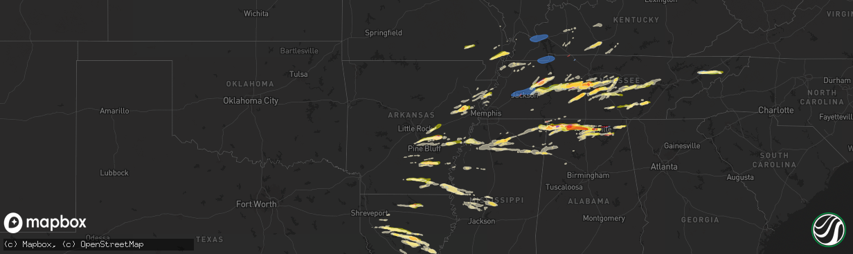
Hail Map in Arkansas on May 20, 2025
The weather event in Arkansas on May 20, 2025 includes Hail, Wind, and Tornado maps. 14 states and 787 cities were impacted and suffered possible damage. The total estimated number of properties impacted is 12,257.
Want more than just the map?
Turn this storm into a full workflow.
- Owner + property data so you know who to knock
- OnDemand branded weather history reports to win the "did we even have hail?" argument
- RoofTrace estimate so reps stop guessing numbers at the door
Bought this map? Upgrade within 7 days and we'll credit the $230. (10-15 min setup call)
Hail
Wind
Tornado
12,257
Estimated number of impacted properties by a 1.00" hail or larger10,423
Estimated number of impacted properties by a 1.75" hail or larger0
Estimated number of impacted properties by a 2.50" hail or largerStorm reports in Arkansas
Arkansas
| Date | Description |
|---|---|
| 05/20/20255:16 PM CDT | Several snapped trees near chicot junction. |
| 05/20/20255:16 PM CDT | Tree downed across southbound lane of us 65. Possible tornado. |
| 05/20/20255:05 PM CDT | Numerous groups of powerlines down at highway 160 & bill young. |
| 05/20/20255:04 PM CDT | This ef1 tornado tracked along ar highway 160 in chicot county... Beginning near the cr 252 intersection and continuing through chicot junction before lifting east of u |
| 05/20/20254:17 PM CDT | Power line down. |
| 05/20/20254:07 PM CDT | A local report indicates 1.00 inch wind near 3 SSE Fountain Hill |
| 05/20/20253:27 PM CDT | Southeast lincoln county fire and rescue shared a picture of measured 1.25 inch hail in chat. |
| 05/20/20253:24 PM CDT | Several power poles down across highway 14 between marie and wilson. |
| 05/20/20253:23 PM CDT | Report from mping: quarter |
| 05/20/20253:19 PM CDT | Half dollar sized hail at big river steel. |
| 05/20/20253:04 PM CDT | A couple of powerlines down. |
| 05/20/20252:44 PM CDT | Golf ball sized hail on falls blvd. Time is radar estimated. |
| 05/20/20252:30 PM CDT | Karhumph3 weather station recorded a 66 mph wind gust when the storm moved through the area at 2:30 pm cdt. |
| 05/20/20252:26 PM CDT | Report of a tree down on ar-193. |
| 05/20/20252:21 PM CDT | Report from mping: quarter |
| 05/20/20252:20 PM CDT | Saw a picture of a 2 inch hailstone next to a ruler on a local broadcast media social media page. |
| 05/20/20252:19 PM CDT | Report from mping: quarter |
All States Impacted by Hail Map on May 20, 2025
Cities Impacted by Hail Map on May 20, 2025
- Ostrander, MN
- Wykoff, MN
- Le Roy, MN
- Spring Valley, MN
- Carrollton, TX
- Plano, TX
- Garland, TX
- Addison, TX
- Grand Prairie, TX
- Dallas, TX
- Bedford, TX
- Coppell, TX
- Grapevine, TX
- Euless, TX
- Arlington, TX
- Hurst, TX
- Naval Air Station Jrb, TX
- North Richland Hills, TX
- Irving, TX
- Haltom City, TX
- Fort Worth, TX
- Richardson, TX
- Colleyville, TX
- Crystal City, TX
- Cotulla, TX
- Dilley, TX
- Pearsall, TX
- Asherton, TX
- Charlotte, TX
- Floresville, TX
- Jourdanton, TX
- Stockdale, TX
- Encinal, TX
- Pleasanton, TX
- Bethel Springs, TN
- Selmer, TN
- Adamsville, TN
- Gillett, TX
- Waterloo, AL
- Jacksonville, IL
- Winchester, IL
- Murrayville, IL
- Sheridan, AR
- Alexander, IL
- Jefferson, AR
- Redfield, AR
- White Hall, AR
- Woodson, IL
- Ashland, IL
- Sherrill, AR
- England, AR
- Tucker, AR
- Crab Orchard, TN
- Rockwood, TN
- Oakdale, TN
- Lonoke, AR
- Carlisle, AR
- Batesville, MS
- Pleasant Plains, IL
- Harriman, TN
- Gable, SC
- Carthage, AR
- Franklin, IL
- New Berlin, IL
- Grandin, MO
- Poplar Bluff, MO
- Parma, MO
- Lilbourn, MO
- Catron, MO
- Tallula, IL
- Hazen, AR
- De Valls Bluff, AR
- Waverly, IL
- Biscoe, AR
- McCrory, AR
- Stuttgart, AR
- Wabbaseka, AR
- Humnoke, AR
- Humphrey, AR
- Pulaski, TN
- New Zion, SC
- Sardis, MS
- Rison, AR
- Roodhouse, IL
- Loami, IL
- Oxford, MS
- Abbeville, MS
- Springfield, IL
- Marked Tree, AR
- Wynne, AR
- Turbeville, SC
- Petersburg, IL
- Altheimer, AR
- Fordyce, AR
- Huron, TN
- Lexington, TN
- Beech Bluff, TN
- Lake City, SC
- Cades, SC
- Wildersville, TN
- Williamsville, MO
- Como, MS
- Tyronza, AR
- Potts Camp, MS
- Darden, TN
- Parsons, TN
- New Edinburg, AR
- Pamplico, SC
- Sikeston, MO
- Lepanto, AR
- Dyess, AR
- Kingsland, AR
- New Madrid, MO
- Chatham, IL
- Waterford, MS
- Holly Springs, MS
- Cantrall, IL
- Caraway, AR
- Manila, AR
- Matthews, MO
- Holladay, TN
- Thaxton, MS
- Etta, MS
- Sherman, IL
- Almyra, AR
- Riverton, IL
- Dawson, IL
- Pekin, IL
- Peoria, IL
- East Peoria, IL
- Creve Coeur, IL
- Charleston, MO
- Louann, AR
- Wilmar, AR
- Casscoe, AR
- Star City, AR
- Parkin, AR
- Colt, AR
- Tiptonville, TN
- Ridgely, TN
- Gresham, SC
- Hayti, MO
- Williamsville, IL
- Athens, IL
- Elkhart, IL
- Johnsonville, SC
- Bertrand, MO
- Osceola, AR
- Centerville, TN
- Sugar Tree, TN
- Lobelville, TN
- Waverly, TN
- Linden, TN
- Buffalo, IL
- Grady, AR
- Dumas, AR
- Hampton, AR
- Forrest City, AR
- Joiner, AR
- Wilson, AR
- East Prairie, MO
- Ringgold, LA
- De Witt, AR
- Crocketts Bluff, AR
- Keiser, AR
- Mansfield, LA
- Roe, AR
- Myrtle, MS
- Dubach, LA
- Timmonsville, SC
- Hornbeak, TN
- Paxton, IL
- Ludlow, IL
- Rantoul, IL
- Mount Pulaski, IL
- Illiopolis, IL
- Jersey, AR
- Hermitage, AR
- Banks, AR
- Coushatta, LA
- Wickliffe, KY
- Barlow, KY
- Lincoln, IL
- Beason, IL
- Gibsland, LA
- Dubberly, LA
- Saint Charles, AR
- Henning, TN
- Union City, TN
- Rives, TN
- Troy, TN
- Latham, IL
- Jamestown, LA
- Hurricane Mills, TN
- Only, TN
- New Albany, MS
- Blue Mountain, MS
- Hemingway, SC
- Heflin, LA
- Warrensburg, IL
- Maroa, IL
- Nunnelly, TN
- Trimble, TN
- Kenton, TN
- Lynchburg, SC
- Olanta, SC
- Winchester, TN
- Estill Springs, TN
- Tullahoma, TN
- Holly Grove, AR
- Ethel, AR
- Dumas, MS
- Martin, TN
- Sharon, TN
- Poplar Grove, AR
- Marvell, AR
- Santa Fe, TN
- Williamsport, TN
- Pickens, AR
- Morristown, TN
- Booneville, MS
- Ripley, MS
- Chestnut, IL
- Luxora, AR
- Decatur, IL
- Rienzi, MS
- Waynesville, IL
- Kenney, IL
- Atlanta, IL
- Clinton, IL
- Bon Aqua, TN
- Lyles, TN
- Mohawk, TN
- Clarendon, AR
- Elaine, AR
- Lexa, AR
- Helena, AR
- Monticello, AR
- Decherd, TN
- Jackson, TN
- Midway, TN
- Fountain Hill, AR
- Hamburg, AR
- Hillsboro, TN
- Russellville, TN
- Bybee, TN
- Cedar Grove, TN
- Downsville, LA
- Duck River, TN
- Ashland, LA
- Saline, LA
- Choudrant, LA
- Farmerville, LA
- Whitesburg, TN
- Primm Springs, TN
- South Fulton, TN
- Oreana, IL
- Franklin, TN
- Baldwyn, MS
- Mosheim, TN
- Greeneville, TN
- Paducah, KY
- Smithland, KY
- Ledbetter, KY
- Brookport, IL
- Calvert City, KY
- Eddyville, KY
- Kuttawa, KY
- Grand Rivers, KY
- Tiline, KY
- Marion, KY
- Gilbertsville, KY
- Benton, KY
- Symsonia, KY
- Dickson, TN
- Fairview, TN
- Iuka, MS
- Friars Point, MS
- Coahoma, MS
- Dundee, MS
- Clarksdale, MS
- Palmersville, TN
- Dresden, TN
- Cherry Valley, AR
- Harrisburg, AR
- Trumann, AR
- Huntingdon, TN
- Yuma, TN
- Paris, TN
- Argenta, IL
- Cisco, IL
- Loda, IL
- Hickory Ridge, AR
- Tishomingo, MS
- Goldonna, LA
- Earle, AR
- Burnsville, MS
- Millington, TN
- Tillar, AR
- Drummonds, TN
- Crossett, AR
- Glen, MS
- Cherokee, AL
- Sterlington, LA
- Weldon, IL
- De Land, IL
- Monticello, IL
- Dodson, LA
- Winnfield, LA
- Columbia, TN
- Puryear, TN
- Hazel, KY
- Thompsons Station, TN
- Murray, KY
- New Concord, KY
- Buchanan, TN
- Spring Hill, TN
- Buena Vista, TN
- Westport, TN
- Sledge, MS
- Marks, MS
- Cottage Grove, TN
- Mahomet, IL
- Mansfield, IL
- White Heath, IL
- Montrose, AR
- Castor, LA
- Camden, TN
- Gibson City, IL
- Afton, TN
- Foosland, IL
- Lawrenceburg, TN
- Summertown, TN
- Fisher, IL
- Scotts Hill, TN
- Watson, AR
- Pelham, TN
- Tracy City, TN
- Dover, TN
- Monteagle, TN
- Dewey, IL
- Buckley, IL
- Ogden, IL
- Saint Joseph, IL
- Homer, IL
- Fithian, IL
- Seymour, IL
- College Grove, TN
- Champaign, IL
- Arrington, TN
- Nolensville, TN
- Sidney, IL
- Penfield, IL
- Gifford, IL
- Lebanon, VA
- Limestone, TN
- Chuckey, TN
- Mount Pleasant, TN
- Brentwood, TN
- Dayton, TX
- Liberty, TX
- Urbana, IL
- Dewitt, IL
- Monroe, LA
- Palmer, TN
- Whitwell, TN
- Armstrong, IL
- Telford, TN
- Jonesborough, TN
- Dunlap, TN
- Brownsville, TN
- Bells, TN
- Denmark, TN
- Oakfield, TN
- Medina, TN
- Culleoka, TN
- Tuscumbia, AL
- Florence, AL
- Muscle Shoals, AL
- Sheffield, AL
- Hopkinsville, KY
- Rankin, IL
- New Johnsonville, TN
- Lyon, MS
- Thomasboro, IL
- Antioch, TN
- Nashville, TN
- Campti, LA
- Madisonville, KY
- Earlington, KY
- Dawson Springs, KY
- Portland, AR
- Killen, AL
- Olla, LA
- Sikes, LA
- Bulls Gap, TN
- Clarksville, TN
- Smyrna, TN
- Murfreesboro, TN
- Saybrook, IL
- Bellflower, IL
- Potomac, IL
- Collison, IL
- Mortons Gap, KY
- White Plains, KY
- Eudora, AR
- Lake Village, AR
- Elkton, KY
- Russellville, AL
- Crenshaw, MS
- Leighton, AL
- Devers, TX
- Savoy, IL
- Greenville, KY
- Hull, TX
- Beulah, MS
- Rockvale, TN
- La Vergne, TN
- Town Creek, AL
- Danville, IL
- Rogersville, AL
- Chapel Hill, TN
- Lewisburg, TN
- Auburn, KY
- Woodburn, KY
- Rossville, IL
- Alvin, IL
- Henning, IL
- Eagleville, TN
- Iron City, TN
- Saint Joseph, TN
- Central City, KY
- Bremen, KY
- Courtland, AL
- Red Bay, AL
- Franklin, KY
- Lambert, MS
- McEwen, TN
- Unionville, TN
- Athens, AL
- Lascassas, TN
- Auburntown, TN
- Milton, TN
- Williamsport, IN
- Beaumont, TX
- Hollandale, MS
- Bismarck, IL
- Bowling Green, KY
- Greenville, MS
- Rockfield, KY
- Russellville, KY
- Alvaton, KY
- Boyle, MS
- Oakwood, IL
- Bondville, IL
- Bell Buckle, TN
- University, MS
- Taylor, MS
- Hillsboro, AL
- Pope, MS
- Courtland, MS
- Christiana, TN
- Elkmont, AL
- West Lebanon, IN
- Readyville, TN
- Kingston Springs, TN
- Kelly, LA
- Shaw, MS
- Doddsville, MS
- Ruleville, MS
- Cleveland, MS
- Gaffney, SC
- Cowpens, SC
- Graham, KY
- Philo, IL
- Soddy Daisy, TN
- Birchwood, TN
- Sale Creek, TN
- Bradyville, TN
- Beechgrove, TN
- Woodbury, TN
- Burns, TN
- Chatham, MS
- Warren, TX
- Water Valley, MS
- Liberty, TN
- Dowelltown, TN
- Adams, TN
- Smithville, TN
- Decatur, TN
- Glen Allan, MS
- Tullos, LA
- Perrysville, IN
- Covington, IN
- Tanner, AL
- Madison, AL
- Athens, TN
- Calhoun, TN
- Cape Girardeau, MO
- Rolling Fork, MS
- Anguilla, MS
- Veedersburg, IN
- Scottsville, KY
- Adolphus, KY
- Lebanon, TN
- Watertown, TN
- Shelbyville, TN
- Morrison, TN
- Mcminnville, TN
- Schlater, MS
- Belzoni, MS
- Pontotoc, MS
- Paris, MS
- Georgetown, LA
- Harvest, AL
- Huntsville, AL
- Manchester, TN
- Fairmount, IL
- Atlanta, LA
- Austin, KY
- Fountain Run, KY
- Rock Island, TN
- Silver City, MS
- Louise, MS
- Trout, LA
- Elliott, IL
- Cissna Park, IL
- Banner, MS
- Greenwood, MS
- Moulton, AL
- Danville, AL
- Wartrace, TN
- Spencer, TN
- Doyle, TN
- Sparta, TN
- Wingate, IN
- Randolph, MS
- Decatur, AL
- Hartselle, AL
- Charlotte, TN
- Mellott, IN
- Waynetown, IN
- Hillsboro, IN
- Glasgow, KY
- Etoile, KY
- Pegram, TN
- Morgantown, KY
- Caneyville, KY
- Quebeck, TN
- Sharon, SC
- Hickory Grove, SC
- Jena, LA
- Owens Cross Roads, AL
- Brownsboro, AL
- Gurley, AL
- Crossville, TN
- Pollock, LA
- Hamilton, AL
- Crawfordsville, IN
- Dry Prong, LA
- Somerville, AL
- Jonesville, LA
- Tremont, MS
- New Richmond, IN
- York, SC
- Millwood, KY
- Leitchfield, KY
- Vina, AL
- Alexandria, TN
- New Market, AL
- Walling, TN
- Trenton, AL
- Hollytree, AL
- Woodville, AL
- Valhermoso Springs, AL
- Laceys Spring, AL
- Tupelo, MS
- Shannon, MS
- Martinsville, IN
- Cloverdale, IN
- Monrovia, IN
- Trinity, AL
- Hackleburg, AL
- Newman, IL
- Allerton, IL
- Lester, AL
- Mooresville, IN
- Linden, IN
- Grandview, TN
- Plantersville, MS
- Goodman, MS
- Pickens, MS
- Chrisman, IL
- Yazoo City, MS
- Stilesville, IN
- Quincy, IN
- Graysville, TN
- Darlington, IN
- Nettleton, MS
- Scottsboro, AL
- Golden, MS
- Fulton, MS
- Stevenson, AL
- Hollywood, AL
- Benton, MS
- Hodges, AL
- Fackler, AL
- Frankfort, IN
- Mantachie, MS
- Camby, IN
- Lena, LA
- Colfax, LA
- Cloutierville, LA
- Paris, IL
- West Union, IL
- Amory, MS
- Flat Rock, AL
- Pisgah, AL
- New Hope, AL
- Grant, AL
- Milford, IL
- Watseka, IL
- Hoopeston, IL
- Sheldon, IL
- Wellington, IL
- Langston, AL
- Stockland, IL
- Ambia, IN
- Fowler, IN
- Royal, IL
- Boswell, IN
- Attica, IN
- Higdon, AL
- Smithville, MS
- Dayton, TN
- Mount Carmel, IL
- Saint Francisville, IL
- Indianapolis, IN
- Greenwood, IN
- Rising Fawn, GA
- Okolona, MS
- Brooklyn, IN
- Guild, TN
- Pikeville, TN
- Bryant, AL
- Trenton, GA
- Chattanooga, TN
- Signal Mountain, TN
- Section, AL
- Monterey, LA
- Greenwood Springs, MS
- Detroit, AL
- Bear Creek, AL
- Bentonia, MS
- Mooreville, MS
- Houlka, MS
- Pineville, LA
- Vaughan, MS
- Dutton, AL
- Terre Haute, IN
- Camden, MS
- Sallis, MS
- Vidalia, LA
- Tinsley, MS
- Satartia, MS
- Westville, IL
- Rosedale, IN
- Brazil, IN
- Alexandria, LA
- Boyce, LA
- Canton, MS
- West Terre Haute, IN
- West York, IL
- Fairland, IN
- Fountaintown, IN
- Shelbyville, IN
- Carthage, MS
- Whiteland, IN
- Center Point, LA
- Deville, LA
- Effie, LA
- Double Springs, AL
- Houston, AL
- Madison, MS
- Flora, MS
- Georgetown, IL
- Morristown, IN
- Eva, TN
- Carbon Hill, AL
- Townley, AL
- Big Sandy, TN
- Marksville, LA
- Oakman, AL
- Jasper, AL
- Lena, MS
- Brandon, MS
- Oak Ridge, TN
- Kingston, TN
- Lenoir City, TN
- Farragut, TN
- Knoxville, TN
- Clinton, TN
- Powell, TN
- Seymour, TN
- Sevierville, TN
- Morton, MS
- Pelahatchie, MS
- Cullman, AL
- Hanceville, AL
- Parrish, AL
- Moreauville, LA
- Forest Hill, LA
- Forest, MS
- Oneonta, AL
- Springville, AL
- Steele, AL
- Lecompte, LA
- Toney, AL
- Woodville, MS
- Angola, LA
- Saint Francisville, LA
- Pineville, KY
- Arjay, KY
- Kettle Island, KY
- Hulen, KY
- Stoney Fork, KY
- Miracle, KY
- Pathfork, KY
- Coldiron, KY
- Bledsoe, KY
- Wallins Creek, KY
- Dayhoit, KY
- Loyall, KY
- Harlan, KY
- Putney, KY
- Baxter, KY
- Totz, KY
- Ages Brookside, KY
- Evarts, KY
- Gordon, KY
- Big Laurel, KY
- Closplint, KY
- Cumberland, KY
- Benham, KY
- Lynch, KY
- Appalachia, VA
- Cheneyville, LA
- Ashville, AL
- Ragland, AL
- Ohatchee, AL
- Walnut Grove, MS
- Anniston, AL
- Heflin, AL
- Ranburne, AL
- Batchelor, LA
- Lettsworth, LA
- Woodworth, LA
- Ball, LA
- Sharpsburg, GA
- Fayetteville, GA
- Palmetto, GA
- Tyrone, GA
- Newnan, GA
- Whitesburg, GA
- Jonesboro, GA
- Peachtree City, GA
- Hampton, GA
- Riverdale, GA
- Forsyth, IL
- Locust Grove, GA
- Jenkinsburg, GA
- Jackson, GA
- Effingham, SC
- Forest Park, GA
- Rex, GA
- Morrow, GA
- Atlanta, GA
- Fairburn, GA
- Stockbridge, GA
- Bonaire, GA
- Kathleen, GA
- Bargersville, IN
- Franklin, IN
- West Newton, IN
- Greencastle, IN
- Dennis, MS
- Paint Rock, AL


