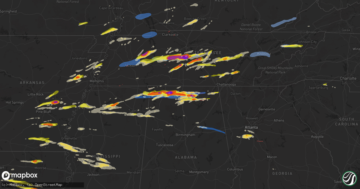
Hail Map on May 20, 2025
Get this storm
May 20 map
$229
one time, instant access
Download today. No call, no setup
Keep the $229
Bought the map and want the full workflow? Apply the entire $229 to a subscription within 7 days. None of it is wasted.
Every map, not just this one
This buys you this map. Subscription and you get every map we run, in the markets you choose from a few cities to whole states to nationwide. Plus real-time alerts the moment a storm fires.
Contact data
Name, contact info, occupancy, even credit band for addresses in the footprint. You go from where it hit to who to call.
Become the source they trust
Unlimited branding weather history reports on demand. You already have the documented answer ready for the property owner, and you are the one who showed up with it.
Property data and RoofTrace estimates
Pull up any address you have got, its value and the exact code rules for that jurisdiction, straight from One Click Code. Then RoofTrace estimates the squares, pitch, and roof value, priced the way you price.
States Impacted by Hail Map on May 20, 2025
Storm reports
Missouri
| Date | Description |
|---|---|
| 05/20/20253:27 PM CDT | Social media report. Time estimated from radar. |
| 05/20/20253:10 PM CDT | Reports of multiple trees down around caruthersville. Time estimated via radar. |
Georgia
| Date | Description |
|---|---|
| 05/20/202510:40 AM CDT | Emergency manager relayed report of multiple trees and powerlines down near park street nw... Including a tree down on a home. |
| 05/20/20253:55 AM CDT | Georgia power website reported power outages on morr |
| 05/20/20253:55 AM CDT | Georgia power website reported power outages on morris calloway road due to a fallen tree. Time estimated by radar. |
| 05/20/20252:57 AM CDT | An ef1 tornado occurred along a 10.5 mile path starting in ne spalding county and ending in butts county near the city of jackson. Max winds 90 mph. |
| 05/20/20252:50 AM CDT | Emergency manager reported a down tre |
| 05/20/20252:50 AM CDT | Emergency manager reported a down tree on halls bridge road. Estimated location. |
| 05/20/20252:48 AM CDT | Emergency manager relayed report of a tree down on plaza drive. |
| 05/20/20252:42 AM CDT | Tree reported down at the intersection of amelia rd and apple rd. |
| 05/20/20252:41 AM CDT | Roof taken off a barn near the intersection of johnson rd and hwy 155. |
| 05/20/20252:24 AM CDT | Emergency manager relayed report of a down tree near vernon ferry road and bailey road. |
| 05/20/20251:56 AM CDT | Public report of 1.5 inch hail in the river crest neighborhood in tyrone. |
| 05/20/20251:00 AM CDT | Emergency manager relayed a report of a tree down across the road near capps ferry road and brecken drive. The downed tree caused an accident... With no injuries. |
| 05/20/202512:55 AM CDT | Broadcast media report of trees down on vehicles along stone rd in southwest atlanta. Radar signatures suggest that a downburst was the likely cause. |
| 05/20/202512:54 AM CDT | Emergency manager reported a downed tree in the 2900 block of tommy dillard road. |
| 05/20/202512:53 AM CDT | Report of a tree in the roadway near the intersection of bethesda church rd and horton rd. |
| 05/20/202512:51 AM CDT | Report of a tree down in the roadway near the intersection of lambert lane and lovvorn road. |
| 05/20/202512:42 AM CDT | Emergency manager reported down tree in the 2000 block of us hwy 78 |
| 05/20/202512:30 AM CDT | Emergency manager relayed a report of a tree down on a powerline near campbellton street and rose circle. |
| 05/20/202512:24 AM CDT | The emergency manager relayed a report of a tree down on the road in the 4000 block of ga highway 5. |
| 05/20/202512:24 AM CDT | The emergency manager relayed a report of a downed tree across pocahontas drive. |
| 05/20/202512:18 AM CDT | Emergency manager relayed a report of a downed tree... Partially blocking the 5000 block of liberty road. |
| 05/19/202511:48 PM CDT | Ham radio operator reported a tree down at a residence near pilgrim mill road and faa road. |
| 05/19/202511:38 PM CDT | Trees have fallen on 2 different homes near the intersection of dena drive and mills wood run. |
| 05/19/202511:15 PM CDT | Public reported a snapped tree and a damaged shade structure at a location off flatbottom road. |
| 05/19/202511:12 PM CDT | Emergency manager reported powerlines down along cut off road. |
| 05/19/202511:08 PM CDT | Tree reported down on a power line on mckelvey dr. |
| 05/19/202511:08 PM CDT | Several trees down near hwy 140 and garland mountain road. |
| 05/19/202511:05 PM CDT | Emergency manager reported several trees down at county line road no. 2 ne and folsom glade road nw. |
| 05/19/202510:50 PM CDT | Emergency manager relayed report of a tree down along county line road no 2. |
| 05/19/202510:48 PM CDT | Emergency manager relayed report of a tree down at clear creek road and pleasant valley road. |
| 05/19/202510:48 PM CDT | Emergency manager reported down tree at richards road and luke quarles road. |
| 05/19/202510:48 PM CDT | Emergency manager reported trees and powerlines down in the 1000 block of cassville pine log road in rydal. |
| 05/19/202510:47 PM CDT | Emergency manager relayed report of a tree down near bible baptist road and yukon trace. |
| 05/19/202510:45 PM CDT | A local report indicates 59 MPH wind near 1 ENE Adairsville |
| 05/19/202510:45 PM CDT | Multiple trees and powerlines down near the intersection of windy hill road se and folsom road. Possible tornado. |
| 05/19/202510:42 PM CDT | Emergency manager reported several trees and powerlines down at tom jones road nw and kingston highway |
| 05/19/202510:40 PM CDT | Emergency manager relayed report of powerlines down on george street nw. |
| 05/19/202510:36 PM CDT | Emergency manager reported trees and powerlines down at westover drive nw and twin bridges road. |
| 05/19/202510:05 PM CDT | Report of tree damage and possible power line issues along cloudland rd in lumpkin county... Ga. |
| 05/19/202510:05 PM CDT | Report of trees and possible power lines down along long branch road in lumpkin county. |
| 05/19/202510:00 PM CDT | Report of tree damage and possible power line damage along summerour rd in lumpkin county. |
| 05/19/202510:00 PM CDT | Tree on a home near the intersection of ridge street and allgood street. |
| 05/19/202510:00 PM CDT | 1 to 2 trees down and powerlines down along edison street. |
| 05/19/20259:57 PM CDT | Downed tree near the intersection of deforest avenue and allgood street. |
| 05/19/20259:55 PM CDT | Tree in the road at haig mill lake road and north bypass blocking the southbound lane. |
| 05/19/20259:50 PM CDT | Tree on a powerline along peach orchard road near menlo. |
| 05/19/20259:50 PM CDT | Tree down near north main st and wardlaw st in lafayette... Ga. |
| 05/19/20259:48 PM CDT | Tree down near the intersection of hwy 151 and hwy 27. |
| 05/19/20259:45 PM CDT | Tree down near hwy 57 and sunshine trail. |
| 05/19/20259:45 PM CDT | Large tree across the road near the intersection of highway 157 and valley view ranch road. |
| 05/19/20259:26 PM CDT | Multiple trees along houston valley road. |
| 05/19/20259:15 PM CDT | Tree down near the intersection of hwy 136 and south dicks creek rd. |
| 05/19/20259:06 PM CDT | The emergency manager relayed a report of a tree in the road on kenny lane. |
| 05/19/20259:05 PM CDT | Report of a downed tree from local em along wood station rd. |
| 05/19/20259:00 PM CDT | The emergency manager relayed a report of a tree in a roadway in the 400 block of wood yates road. |
| 05/19/20258:54 PM CDT | The emergency manager relayed a report of a tree down in the road at w nickajack road. Estimated location. |
| 05/19/20258:36 PM CDT | The emergency manager relayed a report of a tree down in the road near lafayette road and brotherton road. |
| 05/19/20258:36 PM CDT | Emergency manager relayed a report of a tree down across the road near rolling hills drive and post oak road. |
| 05/19/20258:30 PM CDT | Tree down near west 12th st and fouts way in chickamauga. |
Indiana
| Date | Description |
|---|---|
| 05/20/20256:53 PM CDT | Delayed report. Relayed via social media. |
| 05/19/20258:25 PM CDT | Report from mping: quarter |
| 05/19/20257:55 PM CDT | Late report. Most hail under 0.50 inches in diameter. |
| 05/19/20257:21 PM CDT | Delayed report. Trees downed of unknown size. |
Louisiana
| Date | Description |
|---|---|
| 05/20/20256:25 PM CDT | Reported in the beechwood loop area of urania. |
| 05/20/20256:15 PM CDT | Photos of hail ranging from quarter to golf ball in and around the tullos area. |
| 05/20/20256:13 PM CDT | Public reports quarter size hail in the tansey community via broadcast media fb page. |
| 05/19/20259:28 PM CDT | Estimated quarter to half dollar sized hail fell in vick. |
| 05/19/20259:26 PM CDT | Estimated quarter size hail. |
| 05/19/20259:15 PM CDT | Public report quarter size hail in the belah community via broadcast media fb page. |
| 05/19/20258:30 PM CDT | Powerlines and trees down. |
| 05/19/20258:30 PM CDT | Down trees on highway 907. |
| 05/19/20257:30 PM CDT | Corrects previous tstm wnd dmg report from 3 wnw wallace ridge. Several trees down across highway 923 address 2141. |
| 05/19/20257:20 PM CDT | Corrects previous tstm wnd dmg report from 1 ene manifest. |
| 05/19/20257:10 PM CDT | Several trees down across highway 923 address 2141. |
| 05/19/20257:05 PM CDT | Corrects previous tstm wnd dmg report from 1 ene manifest. |
Mississippi
| Date | Description |
|---|---|
| 05/20/20256:22 PM CDT | Reports of tree damage in the ingomar area. |
| 05/20/20256:16 PM CDT | Multiple utility poles were snapped along sunflower river rd in the murphy community. Report and pictures via social media. |
| 05/20/20256:04 PM CDT | Tree down along hwy 436 at beargarden rd. |
| 05/20/20255:41 PM CDT | Multiple trees down near the tocowa area including avery road. Time estimated via radar. |
| 05/20/20255:35 PM CDT | Tree down near the intersection of college hill and heights drive. |
| 05/20/20255:32 PM CDT | Trees down on cr 103. |
| 05/20/20255:03 PM CDT | Tree down at the intersection of belmont rd and river rd just north of the little tallahatchie river. Time estimated via radar. |
| 05/20/20254:18 PM CDT | Report from mping: quarter |
| 05/20/20254:14 PM CDT | Tree on shed on cr 148 between hwy 125 and holcut. |
| 05/20/20253:52 PM CDT | Report of a tree down on cr2371 south of altitude. |
| 05/20/20253:52 PM CDT | Trees down along cr 1101 near booneville. |
| 05/20/20252:35 PM CDT | Golf ball sized hail reported north of oxford. |
| 05/20/20252:29 PM CDT | Quarter sized hail 5mi ne of oxford on hwy 30. |
| 05/20/20252:22 PM CDT | Tree through a house on britton drive. Time is radar estimated. |
| 05/20/20258:09 AM CDT | Tree down on vehicle off of slayden road. |
| 05/20/20257:43 AM CDT | Tree on house on highway 309. Additional trees down on hill view dr. |
| 05/20/20257:42 AM CDT | Trees down on strickland road. Time estimated from radar. |
| 05/19/202510:07 PM CDT | Trees down across roads between conehatta and decatur. |
| 05/19/20259:10 PM CDT | Power line down. |
| 05/19/20259:00 PM CDT | Trees and lines down and power is out. |
| 05/19/20258:48 PM CDT | Some trees down and large limbs on lines in the camden area. Power is out. |
| 05/19/20258:38 PM CDT | A few trees downed n of town. |
| 05/19/20258:34 PM CDT | Power line down. |
| 05/19/20258:32 PM CDT | Power line down. |
| 05/19/20257:43 PM CDT | A local report indicates 1.00 inch wind near 2 S Shannon |
| 05/19/20257:36 PM CDT | Large tree down along the corner of dorsey-evergreen rd and mcmaster rd. |
Alabama
| Date | Description |
|---|---|
| 05/20/20256:59 PM CDT | Report from mping: hen egg |
| 05/20/20256:58 PM CDT | Tree on power lines with one line down. |
| 05/20/20256:57 PM CDT | Golfball hail along drake road in se huntsville. |
| 05/20/20256:57 PM CDT | Baseball hail near southwood church along carl t jones drive in the jones valley area of huntsville. |
| 05/20/20256:55 PM CDT | Report from mping: quarter |
| 05/20/20256:54 PM CDT | Pong pong sized hail reported at huntsville high school. Time estimated by radar. |
| 05/20/20256:54 PM CDT | Egg size hail near the intersection of bob wallace and memorial parkway in huntsville. |
| 05/20/20256:51 PM CDT | Report from mping: quarter |
| 05/20/20256:48 PM CDT | Spotter reported half dollar size hail at the lowes on highway 7 |
| 05/20/20256:48 PM CDT | Spotter reported half dollar size hail at the lowes on highway 73. |
| 05/20/20256:48 PM CDT | Half dollar hail reported on hwy 72 near lowes in madison. |
| 05/20/20256:47 PM CDT | Tree down. Time estimated from radar. |
| 05/20/20256:47 PM CDT | Trees down on vehicles. |
| 05/20/20256:45 PM CDT | Report from mping: quarter |
| 05/20/20256:45 PM CDT | Report from mping: quarter |
| 05/20/20256:45 PM CDT | Large tree snapped. |
| 05/20/20256:44 PM CDT | Quarter sized hail reported on sullivan st in madison. |
| 05/20/20256:41 PM CDT | Report from mping: golf ball |
| 05/20/20256:40 PM CDT | Tree down on house on glenmore dr. |
| 05/20/20256:40 PM CDT | Tree through a house in the area of wedgewood terrace road and nick davis. Time estimated by radar. |
| 05/20/20256:40 PM CDT | Quarter size hail reported at shelton rd and madison blvd. |
| 05/20/20256:39 PM CDT | Report from mping: half dollar |
| 05/20/20256:31 PM CDT | Roof torn off of a two story home as well as significant damage to roofs and walls of surrounding houses. |
| 05/20/20256:31 PM CDT | Public report of a tornado with pictures of multiple trees uprooted... Snapped... And at least one tree on a structure on markum lane. |
| 05/20/20256:30 PM CDT | Numerous trees down near west madison elementary school and the sage trails apartments on wall-triana highway in madison. |
| 05/20/20256:26 PM CDT | Golfball size hail reported near tanner. Time estimated by radar. |
| 05/20/20256:20 PM CDT | Several reports of trees and lines down on mooresville road near greenbrier pkwy. Time estimated by radar. |
| 05/20/20256:20 PM CDT | Storm chaser video confirmation of tornado. |
| 05/20/20256:12 PM CDT | Tree down on a house behind the staples in athens. Time estimated from radar. |
| 05/20/20256:12 PM CDT | Several trees and powerlines down along sanderfer rd. Time estimated from radar. |
| 05/20/20256:12 PM CDT | Several trees and powerlines down alon |
| 05/20/20256:10 PM CDT | Multiple downed power poles and poles snapped on lucas ferry rd just south of hwy 72. |
| 05/20/20256:09 PM CDT | Tree down on hine street south. Time estimated from radar. |
| 05/20/20256:09 PM CDT | An ef-2 tornado with peak wind of 125 mph... Path length of 13.15 miles... And maximum path width 380 yards. |
| 05/20/20256:09 PM CDT | Power lines down along grisby lane and brownsferry roads. Time estimated from radar. |
| 05/20/20256:04 PM CDT | Tree down at hwy 72 and glaze rd. Timer estimated from radar. |
| 05/20/20255:44 PM CDT | Report from mping: quarter |
| 05/20/20255:42 PM CDT | Trees and power lines down along little elk road. Time estimated from radar. |
| 05/20/20255:38 PM CDT | Ema reported baseball size hail in the red bank area south of wheeler dam. |
| 05/20/20255:38 PM CDT | Picture of 3 inch hail in town creek. |
| 05/20/20255:35 PM CDT | Ema reported golf ball sized hail on hwy 72 at the elk river. |
| 05/20/20255:34 PM CDT | Power poles and trees down on county road 389 north of alabama highway 20. Time estimated from radar. |
| 05/20/20255:32 PM CDT | Multiple power poles and trees down cr 605 in the rogersville area. Time estimated by radar. |
| 05/20/20255:26 PM CDT | Social media report of trees down in downtown sheffield al. |
| 05/20/20255:24 PM CDT | Several trees down... Power lines down... And damage to roof tops on homes and barns in the red bank community north of town creek. Time estimated from radar. |
| 05/20/20255:23 PM CDT | 911 call center reported tree down on powerlines at 1405 york st in sheffield. |
| 05/20/20255:23 PM CDT | Tree down on a camper at the big nance mobile home park hwy 101. |
| 05/20/20255:23 PM CDT | 911 call center reported a tree down at 720 gargis hollow rd in muscle shoals al. |
| 05/20/20255:22 PM CDT | Tree down on a house in ford city. |
| 05/20/20255:22 PM CDT | Baseball size hail reported in freeman acres community of lawrence county. |
| 05/20/20255:21 PM CDT | Baseball-size hail along the tennessee river at joe wheeler state park. Time estimated from radar. |
| 05/20/20255:20 PM CDT | 911 call center reports tree down at 1611 tennessee st sheffield al. |
| 05/20/20255:15 PM CDT | 911 center reports a tree down at 3104 ne 19th ave in sheffield al. |
| 05/20/20255:12 PM CDT | Numerous trees down at exit 347 off of i-65 in limestone county. |
| 05/20/20255:12 PM CDT | Social media report of 1.5 inch hail at helton dr in florence al. |
| 05/20/20255:10 PM CDT | Ema reported quarter sized hail at florence highschool. |
| 05/20/20255:06 PM CDT | 911 call center reported a tree down on a house at 407 annapolis ave in sheffield al. |
| 05/20/20254:59 PM CDT | 911 call center reports a tree down on natchez track parkway... 2 miles south of hwy 72. |
| 05/20/20254:53 PM CDT | American red cross reported golf ball sized hail in cherokee al. |
| 05/20/20254:39 PM CDT | 911 call center reported a tree down at 1165 lair ln in colbert county. |
| 05/20/20254:27 PM CDT | Golf ball size observed hail along elk river ese of rogersville. Time estimated from radar. |
| 05/20/20252:22 PM CDT | A tree knocked down in the roadway. Took out several power lines with road completely blocked along lockhart road. |
| 05/20/202512:07 PM CDT | Trees down near cr 10400 near waterloo. Picture and video evidence as well. |
| 05/20/202512:30 AM CDT | Several reports of damage around cr 67... Cr 95... And cr 611. One home was reported to have roof damage. |
| 05/20/202512:07 AM CDT | Tree down on highway 46 and evans bridge rd in heflin. |
| 05/19/202511:35 PM CDT | Numerous trees and power lines down across calhoun county from south of ohatchee to near saks and fort mcclellan. Some trees fell on homes or blocked roads. |
| 05/19/202511:21 PM CDT | Power lines down in the boiling springs area. |
| 05/19/202511:02 PM CDT | Several trees and tree limbs down on cr 26 west of ragland. Much of ragland without power. |
| 05/19/202510:10 PM CDT | Trees and power lines down along cr 114 and cr 41. |
| 05/19/202510:06 PM CDT | Trees down across county road 41 blocking both lanes. |
| 05/19/202510:04 PM CDT | Trees and power lines down on cr 137 and cr 75. |
| 05/19/202510:00 PM CDT | Trees and power lines downed along cr 43... Cr 53... And cr 361. |
| 05/19/20259:56 PM CDT | Large tree down near intersection of al highway 273 near cr 275. |
| 05/19/20259:54 PM CDT | 2 trees down blocking the roadway near the intersection of cr 75 and cr 58. |
| 05/19/20259:32 PM CDT | Trees were downed in the sipsey area. |
| 05/19/20259:18 PM CDT | Trees were downed in the mccollum area along highway 124. |
| 05/19/20259:09 PM CDT | Trees down in the townley area. |
| 05/19/20259:05 PM CDT | Trees down along cr 67... Hwy 71... Cr 372... Cr 156. Time estimated from radar. |
| 05/19/20258:59 PM CDT | Tree down on brock chapel rd. |
| 05/19/20258:57 PM CDT | Trees and power lines down on feemster gap rd. |
| 05/19/20258:48 PM CDT | Tree down and road blockage. |
| 05/19/20258:48 PM CDT | Tree down and road blockage. |
| 05/19/20258:48 PM CDT | Tree down and road blockage. |
| 05/19/20258:47 PM CDT | Report from mping: half dollar |
| 05/19/20258:46 PM CDT | Tree and power lines down. |
| 05/19/20258:46 PM CDT | Power lines down. |
| 05/19/20258:46 PM CDT | Tree down and road blockage. |
| 05/19/20258:46 PM CDT | Tree down and road blockage. Time estimated from radar. |
| 05/19/20258:45 PM CDT | Tree down and road blockage. |
| 05/19/20258:45 PM CDT | Tree down and road blockage. |
| 05/19/20258:37 PM CDT | Tree down on home. Time estimated from radar. |
| 05/19/20258:24 PM CDT | Social media report of trees and power lines down across highway 17 near luster place rd with the highway blocked. |
| 05/19/20258:23 PM CDT | Power lines down resulting in a fire in nearby woods. |
| 05/19/20258:22 PM CDT | Tree down and road blockage. |
| 05/19/20258:15 PM CDT | Tree down in front of falkville heath care... Road impassable. |
| 05/19/20258:10 PM CDT | Tree down on roadway blocking both lanes. |
| 05/19/20258:10 PM CDT | Tree down on a house. |
| 05/19/20258:10 PM CDT | Tree down and road blockage. |
| 05/19/20258:10 PM CDT | Tree and power lines down. |
| 05/19/20258:10 PM CDT | Tree down causing a total road blockage. |
| 05/19/20258:09 PM CDT | Tree and power lines down. |
| 05/19/20258:02 PM CDT | Multiple trees down along hwy 71 in flat rock. Time estimated from radar. |
| 05/19/20258:00 PM CDT | Tree down and road blockage. |
| 05/19/20257:57 PM CDT | Multiple trees down blocking both lanes on cr 5. |
| 05/19/20257:38 PM CDT | Golfball size hail reported at owens cross roads. |
| 05/19/20257:25 PM CDT | Powerlines down on hwy 79 in skyline. Time estimated by radar. |
| 05/19/20257:18 PM CDT | Broken power pole and lines down on cr 20. |
| 05/19/20257:15 PM CDT | Report from mping: ping pong ball |
| 05/19/20257:14 PM CDT | Report from mping: half dollar |
| 05/19/20257:13 PM CDT | Intersection of hwy 65 and county road 10 blocked due to numerous trees down. Time estimated from radar. |
| 05/19/20257:12 PM CDT | Report from mping: half dollar |
| 05/19/20257:10 PM CDT | Quarter sized hail reported in triana. Time estimated from radar. |
| 05/19/20257:10 PM CDT | A local report indicates 1.75 inch wind near 5 E Huntsville |
| 05/19/20257:10 PM CDT | Report from mping: quarter |
| 05/19/20257:08 PM CDT | Power line down in hodges. Time estimated from radar. |
| 05/19/20257:08 PM CDT | Several structures collapsed/power lines and trees down in the area of kilingsworth cove road and jb hawkins road. Time estimated by radar. |
| 05/19/20257:07 PM CDT | An ef-2 with peak wind of 134 mph... Path length of 1.41 miles and maximum path width of 175 yards. |
| 05/19/20257:05 PM CDT | Report from mping: half dollar |
| 05/19/20257:03 PM CDT | Power lines down at the intersection of brock road and hwy 72. Time estimated by radar. |
| 05/19/20257:02 PM CDT | Report from mping: golf ball |
Arkansas
| Date | Description |
|---|---|
| 05/20/20255:16 PM CDT | Several snapped trees near chicot junction. |
| 05/20/20255:16 PM CDT | Tree downed across southbound lane of us 65. Possible tornado. |
| 05/20/20255:05 PM CDT | Numerous groups of powerlines down at highway 160 & bill young. |
| 05/20/20255:04 PM CDT | This ef1 tornado tracked along ar highway 160 in chicot county... Beginning near the cr 252 intersection and continuing through chicot junction before lifting east of u |
| 05/20/20254:17 PM CDT | Power line down. |
| 05/20/20254:07 PM CDT | A local report indicates 1.00 inch wind near 3 SSE Fountain Hill |
| 05/20/20253:27 PM CDT | Southeast lincoln county fire and rescue shared a picture of measured 1.25 inch hail in chat. |
| 05/20/20253:24 PM CDT | Several power poles down across highway 14 between marie and wilson. |
| 05/20/20253:23 PM CDT | Report from mping: quarter |
| 05/20/20253:19 PM CDT | Half dollar sized hail at big river steel. |
| 05/20/20253:04 PM CDT | A couple of powerlines down. |
| 05/20/20252:44 PM CDT | Golf ball sized hail on falls blvd. Time is radar estimated. |
| 05/20/20252:30 PM CDT | Karhumph3 weather station recorded a 66 mph wind gust when the storm moved through the area at 2:30 pm cdt. |
| 05/20/20252:26 PM CDT | Report of a tree down on ar-193. |
| 05/20/20252:21 PM CDT | Report from mping: quarter |
| 05/20/20252:20 PM CDT | Saw a picture of a 2 inch hailstone next to a ruler on a local broadcast media social media page. |
| 05/20/20252:19 PM CDT | Report from mping: quarter |
Texas
| Date | Description |
|---|---|
| 05/20/20255:18 PM CDT | A local report indicates 1.00 inch wind near Devers |
North Carolina
| Date | Description |
|---|---|
| 05/20/20252:30 AM CDT | Tree down on road. |
| 05/20/20252:30 AM CDT | Tree down on road. |
| 05/20/202512:36 AM CDT | Tree down on powerlines. |
| 05/20/202512:35 AM CDT | Trees down on power equipment. |
| 05/20/202512:22 AM CDT | Tree down on cannon ave. |
Illinois
| Date | Description |
|---|---|
| 05/20/20256:50 PM CDT | Widespread tree damage on the south side of westville due to downburst winds. Tree damage included snapped trunks... Large branches snapped... Trees uprooted. Minor roo |
| 05/20/20256:50 PM CDT | 1 to 2 foot diameter pine trees snapped. |
| 05/20/20256:08 PM CDT | Time estimated from radar. |
| 05/20/20255:39 PM CDT | The tornado touched down about 3 miles east of bismark and produced some tree damage along e 2500 north rd. It progressed to the northeast where it damaged the roof of |
| 05/20/20255:35 PM CDT | A local report indicates 1.00 inch wind near 1 N Bismarck |
| 05/20/20255:30 PM CDT | A mile north of intersection of us-136 and il-119. |
| 05/20/20255:19 PM CDT | Video and photos of tornado. |
| 05/20/20255:10 PM CDT | Tree and power line damage along potomac-collison rd. North of county road 2800n. |
| 05/20/20255:06 PM CDT | The weak ef-0 tornado touched down about 4 miles southwest of collison where it did tree damage. It moved east and was video taped by spotters as it passed about 2 mile |
| 05/20/20255:06 PM CDT | The tornado touched down about 3 miles south of armstrong along n 270 east rd where it damaged some trees. It moved east and snapped two power poles along n 650 east rd |
| 05/20/20255:04 PM CDT | Video on social media. |
| 05/20/20254:57 PM CDT | The tornado touched down about 1.5 miles southwest of gerald along county rd 2000 e where it did some tree damage. It then damaged an outbuilding along county rd 2600.. |
| 05/20/20254:45 PM CDT | Relayed by media. |
| 05/20/20254:45 PM CDT | A local report indicates 1.50 inch wind near Mahomet |
| 05/20/20254:42 PM CDT | A local report indicates 1.00 inch wind near Mahomet |
| 05/20/20254:34 PM CDT | Tree down on a vehicle in pittsfield. |
| 05/20/20254:17 PM CDT | 1.5 inch hail and 60 mph winds estimated at location. Time estimated by radar. |
| 05/20/20254:10 PM CDT | Emergency management reported tornado touchdown north of il-9 and 1600 east road west of paxton. |
| 05/20/20254:10 PM CDT | A local report indicates 1.00 inch wind near Fisher |
| 05/20/20254:03 PM CDT | A local report indicates 1.00 inch wind near 1 N Cisco |
| 05/20/20254:00 PM CDT | Corrects previous hail report from paxton. Half dollar size hail in paxton. Relayed by broadcast media. Time estimated by radar. |
| 05/20/20254:00 PM CDT | Half dollar size hail in paxton. Relayed by broadcast media. Time estimated by radar. |
| 05/20/20253:45 PM CDT | A local report indicates 1.00 inch wind near Forsyth |
| 05/20/20253:38 PM CDT | Quarter size hail in paxton. Relayed via broadcast media. Time estimated by radar. |
| 05/20/20253:35 PM CDT | A local report indicates 1.75 inch wind near 1 S Latham |
| 05/20/20253:33 PM CDT | Rain wrapped tornado reported. Relayed by ema. |
| 05/20/20253:29 PM CDT | Photo of hail slightly larger than quarters. |
| 05/20/20253:27 PM CDT | A spotter reported a rain-wrapped tornado south of latham along 2300 ave. No damage was reported. Ef-u rating. |
| 05/20/20253:15 PM CDT | Corrects previous hail report from 1 nw buffalo. Time estimated from radar. |
| 05/20/20252:45 PM CDT | Relayed by media. Time estimated from radar. |
| 05/20/20252:41 PM CDT | A local report indicates 1.25 inch wind near 2 W Springfield |
| 05/20/20252:40 PM CDT | West side of springfield near the intersection of archer elevator and greenbriar rds. |
| 05/20/20252:34 PM CDT | Delayed report. Ping pong sized hail near interchange of highway 97 and highway 4. |
| 05/20/20252:33 PM CDT | Quarter to half dollar size hail at centennial park. |
| 05/20/20252:32 PM CDT | A local report indicates 1.50 inch wind near 1 N Curran |
| 05/20/20252:32 PM CDT | 3-4 diameter tree limbs blown down. |
| 05/20/20252:30 PM CDT | Report from mping: quarter |
| 05/20/20252:30 PM CDT | Video evidence of a tornado touching down briefly. No damage noted. Rating of ef-u. |
| 05/20/20252:28 PM CDT | Time based on radar. |
| 05/20/20252:25 PM CDT | 2-3 diameter tree limbs blown down. |
| 05/20/20252:22 PM CDT | Corrects previous funnel cloud report from oakland. Report from earlier this afternoon. Several funnel cloud pics received... And video of a brief touchdown. |
| 05/20/20252:19 PM CDT | 2 inch diameter branch down. Time estimated from radar. |
| 05/20/20252:19 PM CDT | Corrects previous tstm wnd dmg report from 1 wnw east moline. 2 inch diameter branch down. Time estimated from radar. |
| 05/20/20252:19 PM CDT | 2 inch diameter branch down. Time estimated from radar. |
| 05/20/20252:08 PM CDT | A few very large branches of trees downed. Time estimated using radar. |
| 05/20/20252:07 PM CDT | 7in diameter tree uprooted this afternoon. Time based on radar. |
| 05/20/20252:02 PM CDT | Tree down on i-74 blocking eastbound right lane. |
| 05/20/20252:00 PM CDT | Two two-three inch diameter branches snapped. |
| 05/20/20251:56 PM CDT | A local report indicates 2.00 inch wind near 4 NNW Berlin |
| 05/20/20251:47 PM CDT | Time estimated from radar. |
| 05/20/20251:25 PM CDT | Largest stone measured 1.18 inches. Time estimated from radar. |
| 05/20/20251:24 PM CDT | Measured gust... No damage noted. |
| 05/20/20251:24 PM CDT | A local report indicates 2.00 inch wind near Jacksonville |
| 05/20/20251:24 PM CDT | Quarter to half dollar hail... Relayed by media. |
South Carolina
| Date | Description |
|---|---|
| 05/20/20255:52 PM CDT | Mostly pea-sized hail... But some up to quarters. |
| 05/20/20252:25 PM CDT | Corrects previous hail report from 3 se turbeville. Received a public report of quarter sized hail near the intersection of coker rd and hicks rd... Se of turbeville. |
| 05/20/20252:25 PM CDT | Clarendon county dispatch received a report of quarter sized hail near the intersection of coker rd and hicks rd... Se of turbeville. |
| 05/20/20251:10 AM CDT | Tree in roadway on slab bridge rd near red barn rd. Time estimated from radar. |
| 05/20/20251:08 AM CDT | Tree branches on powerlines. |
| 05/20/202512:59 AM CDT | Down powerlines. |
| 05/20/202512:30 AM CDT | A few trees down in this area. |
Kentucky
| Date | Description |
|---|---|
| 05/20/20256:50 PM CDT | Tree down in upton on the larue county side. |
| 05/20/20256:40 PM CDT | Tree down blocking the roadway near roseville road and cooktown road. Time estimated from radar. |
| 05/20/20256:38 PM CDT | Tree down blocking whole road in the 9000 block of austin tracy rd. Time estimated from radar. |
| 05/20/20256:17 PM CDT | Tree down. Time estimated from radar. |
| 05/20/20256:15 PM CDT | Tree down blocking the road at 641 crawford road. Time estimated from radar. |
| 05/20/20256:14 PM CDT | Tree blocking half the road. |
| 05/20/20256:06 PM CDT | Tree down across the road in the 1600 block of threlkel rd. Time estimated from radar. |
| 05/20/20255:56 PM CDT | Tree down across lane on 23 mile marker southbound. |
| 05/20/20255:55 PM CDT | Metal building in road way. Time estimated from radar. |
| 05/20/20255:54 PM CDT | Tree down in the roadway at 415 caney fork road. Time estimated from radar. |
| 05/20/20255:52 PM CDT | Tree in road at 4011 caneyville road. Time estimated from radar. |
| 05/20/20255:51 PM CDT | Tree down at the intersection of decker road and peonia road. |
| 05/20/20255:49 PM CDT | Tree down in caneyville. Time estimated from radar. |
| 05/20/20255:45 PM CDT | Tree all the way across the road on mckendree chapel rd. Time estimated from radar. |
| 05/20/20255:43 PM CDT | Tree and a powerline down in the road. Provo road. Time estimated from radar. |
| 05/20/20255:33 PM CDT | Tree down blocking matlock rd near rich pond rd. |
| 05/20/20255:02 PM CDT | Several trees down in graham. |
| 05/20/20255:00 PM CDT | Delayed report. A roof blown off a barn... Power poles down... And a few trees down in oakville community. |
| 05/20/20254:59 PM CDT | Trees down north of adairville. |
| 05/20/20254:56 PM CDT | Tree down over road. |
| 05/20/20254:39 PM CDT | Power outages reported. |
| 05/20/20254:32 PM CDT | Power outages and tr |
| 05/20/20254:32 PM CDT | Power outages and trees down. |
| 05/20/20254:17 PM CDT | Power outages reported. |
| 05/20/20253:56 PM CDT | State police reported two trees blocking bell city road... And an outbuilding blown over. |
| 05/20/20253:25 PM CDT | Knott county dept of highways reported a tree down between mm 9 and 10 on ky 550. Time estimated from radar. |
| 05/20/20253:09 PM CDT | A tree was blown down onto ky 699 |
| 05/20/20253:02 PM CDT | Large tree limbs reportedly broken off across from the ekcc entrance just south of west liberty. Event time estimated from radar. |
| 05/20/20252:59 PM CDT | Tree reportedly blown down on grapevine road |
| 05/20/20252:59 PM CDT | A tree was blown down onto us 421 near the leslie county rv park and mm 26. |
| 05/20/20252:56 PM CDT | Tree was reportedly blown down onto power lines along ky-541 near the mount carmel school. |
| 05/20/20252:49 PM CDT | Tree reportedly blown along bowlings creek road about 1.5 miles from the mouth of the holler. Event time estimated from radar. |
| 05/20/20252:37 PM CDT | County dispatch reported multiple trees blown down around the county including up ky-516 and ky-190. Event time estimated from radar. |
| 05/20/20252:29 PM CDT | Tree was reported down near rogers elementary school. Time estimated by radar. |
| 05/20/20252:26 PM CDT | County dispatch reported a tree blown down and partially blocking ky-11 near the knox/clay county line. Even time estimated from radar. |
| 05/20/20252:23 PM CDT | Two trees blown down about a mile from the slade rest area in the vicinity of thatchers bbq. Event time estimated from radar. |
| 05/20/20252:06 PM CDT | Tree reportedly blown down near mm 7 along the hal rogers parkway. Event time estimated from radar. |
| 05/20/20252:02 PM CDT | County dispatch reported tree blown down near the intersection of maplesville school and old salem road. Event time estimated from radar. |
| 05/20/20252:00 PM CDT | Tree blown down at the powell-estill county line... On the powell side. Event time estimated from radar. |
| 05/20/20251:48 PM CDT | County dispatch relayed a report and picture media showed a picture of a tree blown down along the 1900 block of somerset road in the vicinity of allen house lane. Pict |
| 05/20/20251:35 PM CDT | County dispatch reported a tree blown down and partially blocking n ky-66 near the intersection with ky-149. Event time estimated from radar. |
| 05/20/20251:34 PM CDT | A tree was blown down into a light pole on plaza drive near prince royal drive in berea. Time estimated from radar. |
| 05/19/202510:30 PM CDT | Pike county em said that there was a tree down on ky-319 near the hardy ballpark. Time estimated from radar. |
| 05/19/202510:15 PM CDT | A local report indicates 61 MPH wind near 24 E Harlan |
| 05/19/202510:14 PM CDT | Pike county em reported a tree down on the 1800 block of lower pompey branch rd. Time estimated from radar. |
| 05/19/202510:06 PM CDT | Two trees reported down... One of which was blocking nelson branch road. Time is estimated by radar. |
| 05/19/202510:02 PM CDT | Tree damage resulting in 25 customers without power. |
| 05/19/20259:57 PM CDT | A tree was reported to have been blown down onto ky 201in the sitka community. The event time is radar estimated. |
| 05/19/20259:55 PM CDT | A tree was reported to have been blown down on ky 172 in the volga community. The even time is radar estimated. |
| 05/19/20259:35 PM CDT | A tree was blown down onto us 460 near the intersection with grape creek road. The event time is radar estimated. |
| 05/19/20259:19 PM CDT | A large tree and powerlines were reported to have been blown down between mm 12 and the red river elementary school. The event time is radar estimated. |
| 05/19/20259:18 PM CDT | Report via social media of power line down on ky highway 66 from white mountain rd to near long branch rd. Time and location estimated via radar. |
| 05/19/20259:18 PM CDT | 6 trees and a power line down along ky highway 66 in bell county. Time estimated via radar. |
| 05/19/20259:18 PM CDT | Report via social media of power line down on ky highway 66 from white mountain rd to near long branch rd. Time and location esti |
| 05/19/20259:03 PM CDT | Trees were reported to have been blown down on lick fork road in eastern whitely county. The event time is radar estimated. |
| 05/19/20259:01 PM CDT | Tees down on keswick road in southern whitley county. The event time is radar estimated. |
| 05/19/20259:00 PM CDT | One tree down onto ky 11 near 4000 ky 11 campton. The event time is radar estimated. |
| 05/19/20258:57 PM CDT | Trees were reported to have been blown down in the mountain ash community. The event time is radar estimated. |
| 05/19/20258:51 PM CDT | Report via social media of window blown out at a residence by thunderstorm winds along american greeting card rd near corbin. |
| 05/19/20258:51 PM CDT | Trees and powerlines were reported to have been blown down in the bearkat drive vicinity in williamsburg. The event time is radar estimated. |
| 05/19/20258:47 PM CDT | Trees were reported to have been blown down on us 25w near the intersection with lick fork road. The event time is radar estimated. |
| 05/19/20258:45 PM CDT | Laurel county 911 reports a tree down on a house in the 100 block of lawson lane. |
| 05/19/20258:35 PM CDT | Large tree down. Report via social media. Time estimated via radar. |
| 05/19/20258:34 PM CDT | Tree down blocking part of wisemantown rd between richmond rd and s winn rd. Location and time estimated. |
| 05/19/20258:23 PM CDT | A tree was down near mm 10 on us 25 south daniel boone trail. The event time is radar estimated. |
| 05/19/20258:12 PM CDT | Tree down near the entrance to battlefield golf course. Time estimated from radar. |
| 05/19/20258:10 PM CDT | A tree was blow down onto a home at 6342 willailla road... Brodhead... Ky. The time of the event is radar estimated. |
| 05/19/20258:09 PM CDT | A tree was blown down at 2000 scaffold cane road mount vernon in northern rockcastle county. |
| 05/19/20258:03 PM CDT | Tree down on ky 52 just over the madison county line. |
| 05/19/20257:58 PM CDT | Tree down on old fall lick road. |
| 05/19/20257:57 PM CDT | Tree down at the intersection of ky 643 and ky 1781. |
| 05/19/20257:57 PM CDT | Tree down near the 3200 block of past harmons lick road. |
| 05/19/20257:46 PM CDT | Trees down across highway 39. Time estimated from radar. |
| 05/19/20257:45 PM CDT | Trees down across crab orchard road near gilberts creek baptist church. Time estimated from radar. |
| 05/19/20257:43 PM CDT | Tree down blocking the road near the 4900 block of ky 39. |
| 05/19/20257:41 PM CDT | Tree down blocking 1 lane of preachersville road. Time estimated from radar. |
Tennessee
| Date | Description |
|---|---|
| 05/20/20256:46 PM CDT | Estimated ping pong size hail in van buren county. Time estimated from radar. |
| 05/20/20256:44 PM CDT | Several trees down. |
| 05/20/20256:19 PM CDT | Estimated quarter size hail in auburntown. Time estimated from radar. |
| 05/20/20256:15 PM CDT | Report from mping: ping pong ball |
| 05/20/20256:15 PM CDT | Tree blocked johnson hollow road south of interstate 840 near mobleyâs cut road between boston and burwood. Time estimated from radar. |
| 05/20/20256:15 PM CDT | Tree blocked johnson hollow road south of interstate 840 near mobley’s cut road between boston and burwood. Time estimated from radar. |
| 05/20/20256:07 PM CDT | Report from mping: half dollar |
| 05/20/20256:06 PM CDT | Report from mping: ping pong ball |
| 05/20/20255:56 PM CDT | Tree down on ellen drive in goodlettsville. Time estimated from radar. |
| 05/20/20255:55 PM CDT | Large tree down at highway 25 east at cedar grove in cross plains blocking the road. Time estimated from radar. |
| 05/20/20255:51 PM CDT | Tree fell on a vehicle along sr 48 in hickman county. Minor injuries to the driver reported. Time estimated from radar. |
| 05/20/20255:50 PM CDT | Tree down on home in the joelton area. Time estimated by radar. |
| 05/20/20255:50 PM CDT | Several trees down. |
| 05/20/20255:50 PM CDT | Trees and powerlines down in the knob creek and white road areas east of wartrace. Time estimated from radar. |
| 05/20/20255:49 PM CDT | Estimated golf ball size hail near christiana. Time estimated. |
| 05/20/20255:45 PM CDT | Tree down on home on keys branch road near bon aqua. |
| 05/20/20255:41 PM CDT | Report from mping: quarter |
| 05/20/20255:28 PM CDT | Just west of i-24 near sr-76 and hwy-41a. Debris signature on radar. |
| 05/20/20255:25 PM CDT | A nws storm survey team found a ef-0 tornado that occurred in south clarksville. This tornado touched down along e old ashland city rd causing a few trees to lean or fa |
| 05/20/20255:21 PM CDT | Ongoing tornado... Also confirmed by radar. |
| 05/20/20255:20 PM CDT | Trees down. |
| 05/20/20255:19 PM CDT | Downed powerline at florence road & valor drive. Time estimated. |
| 05/20/20255:17 PM CDT | Several large trees down across i-24 at mm72 with trees also down across blackman road. Two lanes of i-24 blocked. Time estimated. |
| 05/20/20255:17 PM CDT | Multiple structures with light damage and dozens of large trees and powerlines down. Time estimated. |
| 05/20/20255:17 PM CDT | Structural damage reported in the blackman area. Time estimated by radar. |
| 05/20/20255:15 PM CDT | 643 customers without power in adams. |
| 05/20/20255:08 PM CDT | A nws storm survey team determined that an ef-0 tornado occurred in north clarksville. This tornado touched down along 101st airborne division rd causing minor tree dam |
| 05/20/20255:02 PM CDT | Measured 2 inch hail on tom osborne road near boyd butler road. Time estimated from radar. |
| 05/20/20255:02 PM CDT | At the maury county office of emergency management. |
| 05/20/20254:59 PM CDT | Report from mping: ping pong ball |
| 05/20/20254:56 PM CDT | Hail a little bigger than quarters reported in columbia. Time estimated from radar. |
| 05/20/20254:55 PM CDT | Tree down on powerline in the springville community. Time is radar estimated. |
| 05/20/20254:55 PM CDT | Quarter size hail reported at maury county eoc. Time estimated from radar. |
| 05/20/20254:55 PM CDT | Ping pong size hail reported at s james campbell blvd and brooksmeade in columbia. |
| 05/20/20254:49 PM CDT | Report from mping: hen egg |
| 05/20/20254:49 PM CDT | Report from mping: ping pong ball |
| 05/20/20254:48 PM CDT | Report from mping: golf ball |
| 05/20/20254:47 PM CDT | Asos station kmkl jackson. |
| 05/20/20254:46 PM CDT | Report from mping: ping pong ball |
| 05/20/20254:46 PM CDT | Report from mping: quarter |
| 05/20/20254:46 PM CDT | Trees down in the 2000 block of highway 120 in big rock. Time estimated. |
| 05/20/20254:45 PM CDT | Report from mping: quarter |
| 05/20/20254:43 PM CDT | A local report indicates 1.00 inch wind near 1 SE Franklin |
| 05/20/20254:42 PM CDT | Measured two inch hail in maplewood subdivision in franklin. Time estimated from radar. |
| 05/20/20254:42 PM CDT | Measured 3 inch hail in franklin. Time estimated from radar. |
| 05/20/20254:42 PM CDT | Estimated quarter size hail on oak meadow drive in franklin. Time estimated from radar. |
| 05/20/20254:41 PM CDT | Quarter to half dollar size hail reported along heathersett drive in dallas downs. |
| 05/20/20254:41 PM CDT | Quarter size hail at jackson street in mount pleasant. Time estimated from radar. |
| 05/20/20254:40 PM CDT | Estimated golf ball size hail near mack hatcher and lewisburg pike near franklin. Time estimated from radar. |
| 05/20/20254:40 PM CDT | Trees and powerlines down at highway 79 and onion hill west of dover. |
| 05/20/20254:40 PM CDT | A nws storm survey team surveyed areas west of dover and determined that straight-line wind damage occurred north of highway 79. Numerous trees were found to be downed. |
| 05/20/20254:40 PM CDT | Estimated golf ball size hail in sullivan farms. Time estimated from radar. |
| 05/20/20254:40 PM CDT | Quarter size hail on goose creek and lewisburg pike near franklin. Time estimated from radar. |
| 05/20/20254:40 PM CDT | Two inch hail measured in sullivan farms. Time estimated from radar. |
| 05/20/20254:40 PM CDT | Em reports downed trees and structure damage west of dover. Time estimated from radar. |
| 05/20/20254:38 PM CDT | Photo received of very large hail on keystone drive south of franklin. Time estimated from radar. |
| 05/20/20254:38 PM CDT | Up to golf ball size hail reported at the public safety center in franklin. Time estimated from radar. |
| 05/20/20254:37 PM CDT | Report from mping: golf ball |
| 05/20/20254:36 PM CDT | Report from mping: quarter |
| 05/20/20254:36 PM CDT | Estimated baseball size hail near franklin. Time estimated from radar. |
| 05/20/20254:35 PM CDT | Video of pingpong ball sized hail and strong wind gusts. |
| 05/20/20254:34 PM CDT | Estimated 1 inch hail at thompson station road and columbia pike. Time estimated from radar. |
| 05/20/20254:34 PM CDT | Estimated tennis ball size hail in thompsons station near i-840. Time estimated from radar. |
| 05/20/20254:34 PM CDT | Estimated from picture received at pratt road in thompsons station. |
| 05/20/20254:30 PM CDT | Several trees down and hail. Hail size unknown. |
| 05/20/20254:21 PM CDT | Golf ball size hail off natchez trace and bending chestnut. Time estimated from radar. |
| 05/20/20254:20 PM CDT | Estimated 2 inch hail in leipers fork. Time estimated from radar. |
| 05/20/20254:18 PM CDT | Tree down on hwy 19 outside of brownsville. Time matched with strong outbound velocity surge on radar. |
| 05/20/20254:18 PM CDT | Photo of significant hail |
| 05/20/20254:17 PM CDT | Trees and powerlines down on ferguson rd in puryear. |
| 05/20/20254:14 PM CDT | Estimated golf ball size hail in primm springs. Time estimated from radar. |
| 05/20/20254:13 PM CDT | Tractor trailer knocked over on snapps ferry rd. Time estimated by radar. |
| 05/20/20254:10 PM CDT | Numerous trees and powerlines down across the city. Time estimated by radar. |
| 05/20/20254:09 PM CDT | Trees down highway 69 n/new boston rd... Cottage grove. |
| 05/20/20254:08 PM CDT | Trees down on blue springs pkwy. Time estimated by radar. |
| 05/20/20254:05 PM CDT | Trees on powerlines. Time estimated by radar. |
| 05/20/20254:03 PM CDT | Trees down on hwy 188 on the gibson/crockett county line in the eaton community. |
| 05/20/20254:00 PM CDT | Public report of penny to quarter sized hail near elkins rd in centerville. |
| 05/20/20254:00 PM CDT | Large tree downed at the intersection of old memphis road and fayne rd. |
| 05/20/20253:56 PM CDT | Golf ball size hail at hickman county high school. |
| 05/20/20253:56 PM CDT | Two inch hail reported near tn 100 and tn 230 north of centerville. Time estimated from radar. |
| 05/20/20253:54 PM CDT | Significant tree damage impacting multiple houses on the west side of martin. Power poles also down. Time is radar estimated. |
| 05/20/20253:54 PM CDT | Estimated 2 inch hail near centerville middle school. Time estimated from radar. |
| 05/20/20253:50 PM CDT | Trees reported down at hickman county high school. Time estimated from radar. |
| 05/20/20253:50 PM CDT | Golf ball size hail reported at hickman county high school. Time estimated from radar. |
| 05/20/20253:47 PM CDT | Trees down on hwy 19 east at old ross road. Time is radar estimated. |
| 05/20/20253:45 PM CDT | Tree down on a house on lee street in martin. Time is radar estimated. |
| 05/20/20253:30 PM CDT | Awos station kucy union city. |
| 05/20/20253:27 PM CDT | Numerous trees down hwy160 near pinebrook. |
| 05/20/20253:25 PM CDT | Multiple trees down across northern perry county... Including along red bank road. Time estimated via radar. |
| 05/20/20253:17 PM CDT | Roof damage noted to the tbi/tn hwy patrol building and additional damage noted at the kirklands warehouse just west of mkl off smith lane. Time is radar estimated. Pos |
| 05/20/20253:15 PM CDT | A brief ef-0 tornado touched down in a wooded area just south of james lawrence road... To the west of smith lane in far southwest jackson... Tn. As the tornado moved n |
| 05/20/20252:59 PM CDT | Tornado viewed on webcam... Also reported by media. |
| 05/20/20252:30 PM CDT | A local report indicates 60 MPH wind near Powell |
| 05/20/20252:28 PM CDT | Trees down on sand ridge bargerton rd. |
| 05/20/20252:10 PM CDT | Power lines down at lookout ave. |
| 05/20/20251:17 PM CDT | Delayed report. Emergency manager reports of damage in chapel hill. Possible tornado. Time estimated from radar. |
| 05/20/202510:30 AM CDT | Emergency manager reports several large trees down... As well as damage to a few sheds. From em and pictures... Everything blown east. |
| 05/20/202510:00 AM CDT | Reported tree down in michie... Tn. Time estimated on radar. |
| 05/20/20259:58 AM CDT | Reported tree down along highway 142 and kimberly ln. Time estimated on radar. |
| 05/20/20259:51 AM CDT | Em reported tree fallen along clifton rd and phillips dr. Time estimated using radar. |
| 05/19/20259:50 PM CDT | Large tree down blocking at least a lane on highway 441 going north near zion hill area. |
| 05/19/20259:42 PM CDT | Several trees down. |
| 05/19/20259:40 PM CDT | A few trees down. |
| 05/19/20259:27 PM CDT | Trees down at maryville housing authority. |
| 05/19/20259:15 PM CDT | Trees down county-wide. |
| 05/19/20259:10 PM CDT | Re-sending report. Measured on an at home anemometer. |
| 05/19/20258:51 PM CDT | Trees down. |
| 05/19/20258:50 PM CDT | Several trees down. |
| 05/19/20258:45 PM CDT | Several trees down. |
| 05/19/20258:40 PM CDT | Trees reported down in scott county. |
| 05/19/20258:31 PM CDT | Damage reported at vandever road and highway 127. Time estimated from radar. |
| 05/19/20258:05 PM CDT | Structure damage reported on rhea road. Time estimated. |
| 05/19/20258:00 PM CDT | Golf ball size hail on burgess road. Time estimated. |
| 05/19/20257:40 PM CDT | Multiple trees down across western and central putnam county. Time estimated. |
| 05/19/20257:40 PM CDT | Correct previous report from 1 nnw crossville. Multiple trees down across western and central putnam county. Time estimated. |
| 05/19/20257:39 PM CDT | Trees down and nickel size hail. |
| 05/19/20257:37 PM CDT | A nws storm survey team determined that an ef-1 tornado occurred in southern cumberland county. This tornado touched down along vandever rd near new era causing timber |
| 05/19/20257:01 PM CDT | Quarter-size hail in quebeck. |
Virginia
| Date | Description |
|---|---|
| 05/20/20255:00 PM CDT | Trees down and reports of hail. Hail size unknown. |
| 05/20/20254:18 PM CDT | Trees down. Time estimated by radar. Time estimated by radar. |
| 05/19/202511:02 PM CDT | Tree damage resulting in 80 customers without power. |
| 05/19/202510:56 PM CDT | Tree down along bad rdg. |
| 05/19/202510:40 PM CDT | Trees down. |
Cities Impacted by Hail Map on May 20, 2025
- Ostrander, MN
- Wykoff, MN
- Le Roy, MN
- Spring Valley, MN
- Carrollton, TX
- Plano, TX
- Garland, TX
- Addison, TX
- Grand Prairie, TX
- Dallas, TX
- Bedford, TX
- Coppell, TX
- Grapevine, TX
- Euless, TX
- Arlington, TX
- Hurst, TX
- Naval Air Station Jrb, TX
- North Richland Hills, TX
- Irving, TX
- Haltom City, TX
- Fort Worth, TX
- Richardson, TX
- Colleyville, TX
- Crystal City, TX
- Cotulla, TX
- Dilley, TX
- Pearsall, TX
- Asherton, TX
- Charlotte, TX
- Floresville, TX
- Jourdanton, TX
- Stockdale, TX
- Encinal, TX
- Pleasanton, TX
- Bethel Springs, TN
- Selmer, TN
- Adamsville, TN
- Gillett, TX
- Waterloo, AL
- Jacksonville, IL
- Winchester, IL
- Murrayville, IL
- Sheridan, AR
- Alexander, IL
- Jefferson, AR
- Redfield, AR
- White Hall, AR
- Woodson, IL
- Ashland, IL
- Sherrill, AR
- England, AR
- Tucker, AR
- Crab Orchard, TN
- Rockwood, TN
- Oakdale, TN
- Lonoke, AR
- Carlisle, AR
- Batesville, MS
- Pleasant Plains, IL
- Harriman, TN
- Gable, SC
- Carthage, AR
- Franklin, IL
- New Berlin, IL
- Grandin, MO
- Poplar Bluff, MO
- Parma, MO
- Lilbourn, MO
- Catron, MO
- Tallula, IL
- Hazen, AR
- De Valls Bluff, AR
- Waverly, IL
- Biscoe, AR
- McCrory, AR
- Stuttgart, AR
- Wabbaseka, AR
- Humnoke, AR
- Humphrey, AR
- Pulaski, TN
- New Zion, SC
- Sardis, MS
- Rison, AR
- Roodhouse, IL
- Loami, IL
- Oxford, MS
- Abbeville, MS
- Springfield, IL
- Marked Tree, AR
- Wynne, AR
- Turbeville, SC
- Petersburg, IL
- Altheimer, AR
- Fordyce, AR
- Huron, TN
- Lexington, TN
- Beech Bluff, TN
- Lake City, SC
- Cades, SC
- Wildersville, TN
- Williamsville, MO
- Como, MS
- Tyronza, AR
- Potts Camp, MS
- Darden, TN
- Parsons, TN
- New Edinburg, AR
- Pamplico, SC
- Sikeston, MO
- Lepanto, AR
- Dyess, AR
- Kingsland, AR
- New Madrid, MO
- Chatham, IL
- Waterford, MS
- Holly Springs, MS
- Cantrall, IL
- Caraway, AR
- Manila, AR
- Matthews, MO
- Holladay, TN
- Thaxton, MS
- Etta, MS
- Sherman, IL
- Almyra, AR
- Riverton, IL
- Dawson, IL
- Pekin, IL
- Peoria, IL
- East Peoria, IL
- Creve Coeur, IL
- Charleston, MO
- Louann, AR
- Wilmar, AR
- Casscoe, AR
- Star City, AR
- Parkin, AR
- Colt, AR
- Tiptonville, TN
- Ridgely, TN
- Gresham, SC
- Hayti, MO
- Williamsville, IL
- Athens, IL
- Elkhart, IL
- Johnsonville, SC
- Bertrand, MO
- Osceola, AR
- Centerville, TN
- Sugar Tree, TN
- Lobelville, TN
- Waverly, TN
- Linden, TN
- Buffalo, IL
- Grady, AR
- Dumas, AR
- Hampton, AR
- Forrest City, AR
- Joiner, AR
- Wilson, AR
- East Prairie, MO
- Ringgold, LA
- De Witt, AR
- Crocketts Bluff, AR
- Keiser, AR
- Mansfield, LA
- Roe, AR
- Myrtle, MS
- Dubach, LA
- Timmonsville, SC
- Hornbeak, TN
- Paxton, IL
- Ludlow, IL
- Rantoul, IL
- Mount Pulaski, IL
- Illiopolis, IL
- Jersey, AR
- Hermitage, AR
- Banks, AR
- Coushatta, LA
- Wickliffe, KY
- Barlow, KY
- Lincoln, IL
- Beason, IL
- Gibsland, LA
- Dubberly, LA
- Saint Charles, AR
- Henning, TN
- Union City, TN
- Rives, TN
- Troy, TN
- Latham, IL
- Jamestown, LA
- Hurricane Mills, TN
- Only, TN
- New Albany, MS
- Blue Mountain, MS
- Hemingway, SC
- Heflin, LA
- Warrensburg, IL
- Maroa, IL
- Nunnelly, TN
- Trimble, TN
- Kenton, TN
- Lynchburg, SC
- Olanta, SC
- Winchester, TN
- Estill Springs, TN
- Tullahoma, TN
- Holly Grove, AR
- Ethel, AR
- Dumas, MS
- Martin, TN
- Sharon, TN
- Poplar Grove, AR
- Marvell, AR
- Santa Fe, TN
- Williamsport, TN
- Pickens, AR
- Morristown, TN
- Booneville, MS
- Ripley, MS
- Chestnut, IL
- Luxora, AR
- Decatur, IL
- Rienzi, MS
- Waynesville, IL
- Kenney, IL
- Atlanta, IL
- Clinton, IL
- Bon Aqua, TN
- Lyles, TN
- Mohawk, TN
- Clarendon, AR
- Elaine, AR
- Lexa, AR
- Helena, AR
- Monticello, AR
- Decherd, TN
- Jackson, TN
- Midway, TN
- Fountain Hill, AR
- Hamburg, AR
- Hillsboro, TN
- Russellville, TN
- Bybee, TN
- Cedar Grove, TN
- Downsville, LA
- Duck River, TN
- Ashland, LA
- Saline, LA
- Choudrant, LA
- Farmerville, LA
- Whitesburg, TN
- Primm Springs, TN
- South Fulton, TN
- Oreana, IL
- Franklin, TN
- Baldwyn, MS
- Mosheim, TN
- Greeneville, TN
- Paducah, KY
- Smithland, KY
- Ledbetter, KY
- Brookport, IL
- Calvert City, KY
- Eddyville, KY
- Kuttawa, KY
- Grand Rivers, KY
- Tiline, KY
- Marion, KY
- Gilbertsville, KY
- Benton, KY
- Symsonia, KY
- Dickson, TN
- Fairview, TN
- Iuka, MS
- Friars Point, MS
- Coahoma, MS
- Dundee, MS
- Clarksdale, MS
- Palmersville, TN
- Dresden, TN
- Cherry Valley, AR
- Harrisburg, AR
- Trumann, AR
- Huntingdon, TN
- Yuma, TN
- Paris, TN
- Argenta, IL
- Cisco, IL
- Loda, IL
- Hickory Ridge, AR
- Tishomingo, MS
- Goldonna, LA
- Earle, AR
- Burnsville, MS
- Millington, TN
- Tillar, AR
- Drummonds, TN
- Crossett, AR
- Glen, MS
- Cherokee, AL
- Sterlington, LA
- Weldon, IL
- De Land, IL
- Monticello, IL
- Dodson, LA
- Winnfield, LA
- Columbia, TN
- Puryear, TN
- Hazel, KY
- Thompsons Station, TN
- Murray, KY
- New Concord, KY
- Buchanan, TN
- Spring Hill, TN
- Buena Vista, TN
- Westport, TN
- Sledge, MS
- Marks, MS
- Cottage Grove, TN
- Mahomet, IL
- Mansfield, IL
- White Heath, IL
- Montrose, AR
- Castor, LA
- Camden, TN
- Gibson City, IL
- Afton, TN
- Foosland, IL
- Lawrenceburg, TN
- Summertown, TN
- Fisher, IL
- Scotts Hill, TN
- Watson, AR
- Pelham, TN
- Tracy City, TN
- Dover, TN
- Monteagle, TN
- Dewey, IL
- Buckley, IL
- Ogden, IL
- Saint Joseph, IL
- Homer, IL
- Fithian, IL
- Seymour, IL
- College Grove, TN
- Champaign, IL
- Arrington, TN
- Nolensville, TN
- Sidney, IL
- Penfield, IL
- Gifford, IL
- Lebanon, VA
- Limestone, TN
- Chuckey, TN
- Mount Pleasant, TN
- Brentwood, TN
- Dayton, TX
- Liberty, TX
- Urbana, IL
- Dewitt, IL
- Monroe, LA
- Palmer, TN
- Whitwell, TN
- Armstrong, IL
- Telford, TN
- Jonesborough, TN
- Dunlap, TN
- Brownsville, TN
- Bells, TN
- Denmark, TN
- Oakfield, TN
- Medina, TN
- Culleoka, TN
- Tuscumbia, AL
- Florence, AL
- Muscle Shoals, AL
- Sheffield, AL
- Hopkinsville, KY
- Rankin, IL
- New Johnsonville, TN
- Lyon, MS
- Thomasboro, IL
- Antioch, TN
- Nashville, TN
- Campti, LA
- Madisonville, KY
- Earlington, KY
- Dawson Springs, KY
- Portland, AR
- Killen, AL
- Olla, LA
- Sikes, LA
- Bulls Gap, TN
- Clarksville, TN
- Smyrna, TN
- Murfreesboro, TN
- Saybrook, IL
- Bellflower, IL
- Potomac, IL
- Collison, IL
- Mortons Gap, KY
- White Plains, KY
- Eudora, AR
- Lake Village, AR
- Elkton, KY
- Russellville, AL
- Crenshaw, MS
- Leighton, AL
- Devers, TX
- Savoy, IL
- Greenville, KY
- Hull, TX
- Beulah, MS
- Rockvale, TN
- La Vergne, TN
- Town Creek, AL
- Danville, IL
- Rogersville, AL
- Chapel Hill, TN
- Lewisburg, TN
- Auburn, KY
- Woodburn, KY
- Rossville, IL
- Alvin, IL
- Henning, IL
- Eagleville, TN
- Iron City, TN
- Saint Joseph, TN
- Central City, KY
- Bremen, KY
- Courtland, AL
- Red Bay, AL
- Franklin, KY
- Lambert, MS
- McEwen, TN
- Unionville, TN
- Athens, AL
- Lascassas, TN
- Auburntown, TN
- Milton, TN
- Williamsport, IN
- Beaumont, TX
- Hollandale, MS
- Bismarck, IL
- Bowling Green, KY
- Greenville, MS
- Rockfield, KY
- Russellville, KY
- Alvaton, KY
- Boyle, MS
- Oakwood, IL
- Bondville, IL
- Bell Buckle, TN
- University, MS
- Taylor, MS
- Hillsboro, AL
- Pope, MS
- Courtland, MS
- Christiana, TN
- Elkmont, AL
- West Lebanon, IN
- Readyville, TN
- Kingston Springs, TN
- Kelly, LA
- Shaw, MS
- Doddsville, MS
- Ruleville, MS
- Cleveland, MS
- Gaffney, SC
- Cowpens, SC
- Graham, KY
- Philo, IL
- Soddy Daisy, TN
- Birchwood, TN
- Sale Creek, TN
- Bradyville, TN
- Beechgrove, TN
- Woodbury, TN
- Burns, TN
- Chatham, MS
- Warren, TX
- Water Valley, MS
- Liberty, TN
- Dowelltown, TN
- Adams, TN
- Smithville, TN
- Decatur, TN
- Glen Allan, MS
- Tullos, LA
- Perrysville, IN
- Covington, IN
- Tanner, AL
- Madison, AL
- Athens, TN
- Calhoun, TN
- Cape Girardeau, MO
- Rolling Fork, MS
- Anguilla, MS
- Veedersburg, IN
- Scottsville, KY
- Adolphus, KY
- Lebanon, TN
- Watertown, TN
- Shelbyville, TN
- Morrison, TN
- Mcminnville, TN
- Schlater, MS
- Belzoni, MS
- Pontotoc, MS
- Paris, MS
- Georgetown, LA
- Harvest, AL
- Huntsville, AL
- Manchester, TN
- Fairmount, IL
- Atlanta, LA
- Austin, KY
- Fountain Run, KY
- Rock Island, TN
- Silver City, MS
- Louise, MS
- Trout, LA
- Elliott, IL
- Cissna Park, IL
- Banner, MS
- Greenwood, MS
- Moulton, AL
- Danville, AL
- Wartrace, TN
- Spencer, TN
- Doyle, TN
- Sparta, TN
- Wingate, IN
- Randolph, MS
- Decatur, AL
- Hartselle, AL
- Charlotte, TN
- Mellott, IN
- Waynetown, IN
- Hillsboro, IN
- Glasgow, KY
- Etoile, KY
- Pegram, TN
- Morgantown, KY
- Caneyville, KY
- Quebeck, TN
- Sharon, SC
- Hickory Grove, SC
- Jena, LA
- Owens Cross Roads, AL
- Brownsboro, AL
- Gurley, AL
- Crossville, TN
- Pollock, LA
- Hamilton, AL
- Crawfordsville, IN
- Dry Prong, LA
- Somerville, AL
- Jonesville, LA
- Tremont, MS
- New Richmond, IN
- York, SC
- Millwood, KY
- Leitchfield, KY
- Vina, AL
- Alexandria, TN
- New Market, AL
- Walling, TN
- Trenton, AL
- Hollytree, AL
- Woodville, AL
- Valhermoso Springs, AL
- Laceys Spring, AL
- Tupelo, MS
- Shannon, MS
- Martinsville, IN
- Cloverdale, IN
- Monrovia, IN
- Trinity, AL
- Hackleburg, AL
- Newman, IL
- Allerton, IL
- Lester, AL
- Mooresville, IN
- Linden, IN
- Grandview, TN
- Plantersville, MS
- Goodman, MS
- Pickens, MS
- Chrisman, IL
- Yazoo City, MS
- Stilesville, IN
- Quincy, IN
- Graysville, TN
- Darlington, IN
- Nettleton, MS
- Scottsboro, AL
- Golden, MS
- Fulton, MS
- Stevenson, AL
- Hollywood, AL
- Benton, MS
- Hodges, AL
- Fackler, AL
- Frankfort, IN
- Mantachie, MS
- Camby, IN
- Lena, LA
- Colfax, LA
- Cloutierville, LA
- Paris, IL
- West Union, IL
- Amory, MS
- Flat Rock, AL
- Pisgah, AL
- New Hope, AL
- Grant, AL
- Milford, IL
- Watseka, IL
- Hoopeston, IL
- Sheldon, IL
- Wellington, IL
- Langston, AL
- Stockland, IL
- Ambia, IN
- Fowler, IN
- Royal, IL
- Boswell, IN
- Attica, IN
- Higdon, AL
- Smithville, MS
- Dayton, TN
- Mount Carmel, IL
- Saint Francisville, IL
- Indianapolis, IN
- Greenwood, IN
- Rising Fawn, GA
- Okolona, MS
- Brooklyn, IN
- Guild, TN
- Pikeville, TN
- Bryant, AL
- Trenton, GA
- Chattanooga, TN
- Signal Mountain, TN
- Section, AL
- Monterey, LA
- Greenwood Springs, MS
- Detroit, AL
- Bear Creek, AL
- Bentonia, MS
- Mooreville, MS
- Houlka, MS
- Pineville, LA
- Vaughan, MS
- Dutton, AL
- Terre Haute, IN
- Camden, MS
- Sallis, MS
- Vidalia, LA
- Tinsley, MS
- Satartia, MS
- Westville, IL
- Rosedale, IN
- Brazil, IN
- Alexandria, LA
- Boyce, LA
- Canton, MS
- West Terre Haute, IN
- West York, IL
- Fairland, IN
- Fountaintown, IN
- Shelbyville, IN
- Carthage, MS
- Whiteland, IN
- Center Point, LA
- Deville, LA
- Effie, LA
- Double Springs, AL
- Houston, AL
- Madison, MS
- Flora, MS
- Georgetown, IL
- Morristown, IN
- Eva, TN
- Carbon Hill, AL
- Townley, AL
- Big Sandy, TN
- Marksville, LA
- Oakman, AL
- Jasper, AL
- Lena, MS
- Brandon, MS
- Oak Ridge, TN
- Kingston, TN
- Lenoir City, TN
- Farragut, TN
- Knoxville, TN
- Clinton, TN
- Powell, TN
- Seymour, TN
- Sevierville, TN
- Morton, MS
- Pelahatchie, MS
- Cullman, AL
- Hanceville, AL
- Parrish, AL
- Moreauville, LA
- Forest Hill, LA
- Forest, MS
- Oneonta, AL
- Springville, AL
- Steele, AL
- Lecompte, LA
- Toney, AL
- Woodville, MS
- Angola, LA
- Saint Francisville, LA
- Pineville, KY
- Arjay, KY
- Kettle Island, KY
- Hulen, KY
- Stoney Fork, KY
- Miracle, KY
- Pathfork, KY
- Coldiron, KY
- Bledsoe, KY
- Wallins Creek, KY
- Dayhoit, KY
- Loyall, KY
- Harlan, KY
- Putney, KY
- Baxter, KY
- Totz, KY
- Ages Brookside, KY
- Evarts, KY
- Gordon, KY
- Big Laurel, KY
- Closplint, KY
- Cumberland, KY
- Benham, KY
- Lynch, KY
- Appalachia, VA
- Cheneyville, LA
- Ashville, AL
- Ragland, AL
- Ohatchee, AL
- Walnut Grove, MS
- Anniston, AL
- Heflin, AL
- Ranburne, AL
- Batchelor, LA
- Lettsworth, LA
- Woodworth, LA
- Ball, LA
- Sharpsburg, GA
- Fayetteville, GA
- Palmetto, GA
- Tyrone, GA
- Newnan, GA
- Whitesburg, GA
- Jonesboro, GA
- Peachtree City, GA
- Hampton, GA
- Riverdale, GA
- Forsyth, IL
- Locust Grove, GA
- Jenkinsburg, GA
- Jackson, GA
- Effingham, SC
- Forest Park, GA
- Rex, GA
- Morrow, GA
- Atlanta, GA
- Fairburn, GA
- Stockbridge, GA
- Bonaire, GA
- Kathleen, GA
- Bargersville, IN
- Franklin, IN
- West Newton, IN
- Greencastle, IN
- Dennis, MS
- Paint Rock, AL