Hail Map in Alabama on May 20, 2025
The weather event in Alabama on May 20, 2025 includes Hail, Wind, and Tornado maps. 14 states and 787 cities were impacted and suffered possible damage. The total estimated number of properties impacted is 107,114.
Want more than just the map?
Turn this storm into a full workflow.
- Owner + property data so you know who to knock
- OnDemand branded weather history reports to win the "did we even have hail?" argument
- RoofTrace estimate so reps stop guessing numbers at the door
Bought this map? Upgrade within 7 days and we'll credit the $230. (10-15 min setup call)
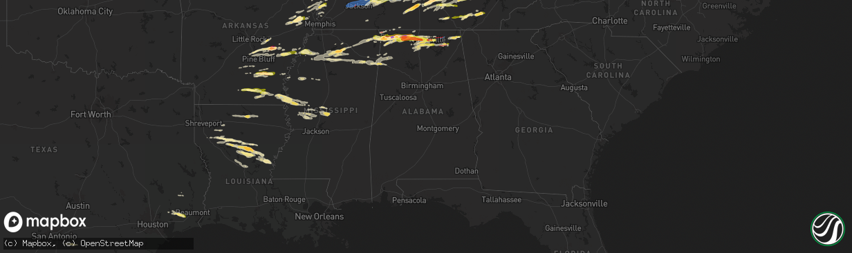
Hail
Wind
Tornado
107,114
Estimated number of impacted properties by a 1.00" hail or larger49,838
Estimated number of impacted properties by a 1.75" hail or larger9,794
Estimated number of impacted properties by a 2.50" hail or largerStorm reports in Alabama
Alabama
| Date | Description |
|---|---|
| 05/20/20256:59 PM CDT | Report from mping: hen egg |
| 05/20/20256:58 PM CDT | Tree on power lines with one line down. |
| 05/20/20256:57 PM CDT | Golfball hail along drake road in se huntsville. |
| 05/20/20256:57 PM CDT | Baseball hail near southwood church along carl t jones drive in the jones valley area of huntsville. |
| 05/20/20256:55 PM CDT | Report from mping: quarter |
| 05/20/20256:54 PM CDT | Egg size hail near the intersection of bob wallace and memorial parkway in huntsville. |
| 05/20/20256:54 PM CDT | Pong pong sized hail reported at huntsville high school. Time estimated by radar. |
| 05/20/20256:51 PM CDT | Report from mping: quarter |
| 05/20/20256:48 PM CDT | Half dollar hail reported on hwy 72 near lowes in madison. |
| 05/20/20256:48 PM CDT | Spotter reported half dollar size hail at the lowes on highway 73. |
| 05/20/20256:48 PM CDT | Spotter reported half dollar size hail at the lowes on highway 7 |
| 05/20/20256:47 PM CDT | Trees down on vehicles. |
| 05/20/20256:47 PM CDT | Tree down. Time estimated from radar. |
| 05/20/20256:45 PM CDT | Report from mping: quarter |
| 05/20/20256:45 PM CDT | Large tree snapped. |
| 05/20/20256:45 PM CDT | Report from mping: quarter |
| 05/20/20256:44 PM CDT | Quarter sized hail reported on sullivan st in madison. |
| 05/20/20256:41 PM CDT | Report from mping: golf ball |
| 05/20/20256:40 PM CDT | Tree through a house in the area of wedgewood terrace road and nick davis. Time estimated by radar. |
| 05/20/20256:40 PM CDT | Tree down on house on glenmore dr. |
| 05/20/20256:40 PM CDT | Quarter size hail reported at shelton rd and madison blvd. |
| 05/20/20256:39 PM CDT | Report from mping: half dollar |
| 05/20/20256:31 PM CDT | Roof torn off of a two story home as well as significant damage to roofs and walls of surrounding houses. |
| 05/20/20256:31 PM CDT | Public report of a tornado with pictures of multiple trees uprooted... Snapped... And at least one tree on a structure on markum lane. |
| 05/20/20256:30 PM CDT | Numerous trees down near west madison elementary school and the sage trails apartments on wall-triana highway in madison. |
| 05/20/20256:26 PM CDT | Golfball size hail reported near tanner. Time estimated by radar. |
| 05/20/20256:20 PM CDT | Storm chaser video confirmation of tornado. |
| 05/20/20256:20 PM CDT | Several reports of trees and lines down on mooresville road near greenbrier pkwy. Time estimated by radar. |
| 05/20/20256:12 PM CDT | Several trees and powerlines down along sanderfer rd. Time estimated from radar. |
| 05/20/20256:12 PM CDT | Several trees and powerlines down alon |
| 05/20/20256:12 PM CDT | Tree down on a house behind the staples in athens. Time estimated from radar. |
| 05/20/20256:10 PM CDT | Multiple downed power poles and poles snapped on lucas ferry rd just south of hwy 72. |
| 05/20/20256:09 PM CDT | Power lines down along grisby lane and brownsferry roads. Time estimated from radar. |
| 05/20/20256:09 PM CDT | Tree down on hine street south. Time estimated from radar. |
| 05/20/20256:09 PM CDT | An ef-2 tornado with peak wind of 125 mph... Path length of 13.15 miles... And maximum path width 380 yards. |
| 05/20/20256:04 PM CDT | Tree down at hwy 72 and glaze rd. Timer estimated from radar. |
| 05/20/20255:44 PM CDT | Report from mping: quarter |
| 05/20/20255:42 PM CDT | Trees and power lines down along little elk road. Time estimated from radar. |
| 05/20/20255:38 PM CDT | Ema reported baseball size hail in the red bank area south of wheeler dam. |
| 05/20/20255:38 PM CDT | Picture of 3 inch hail in town creek. |
| 05/20/20255:35 PM CDT | Ema reported golf ball sized hail on hwy 72 at the elk river. |
| 05/20/20255:34 PM CDT | Power poles and trees down on county road 389 north of alabama highway 20. Time estimated from radar. |
| 05/20/20255:32 PM CDT | Multiple power poles and trees down cr 605 in the rogersville area. Time estimated by radar. |
| 05/20/20255:26 PM CDT | Social media report of trees down in downtown sheffield al. |
| 05/20/20255:24 PM CDT | Several trees down... Power lines down... And damage to roof tops on homes and barns in the red bank community north of town creek. Time estimated from radar. |
| 05/20/20255:23 PM CDT | Tree down on a camper at the big nance mobile home park hwy 101. |
| 05/20/20255:23 PM CDT | 911 call center reported tree down on powerlines at 1405 york st in sheffield. |
| 05/20/20255:23 PM CDT | 911 call center reported a tree down at 720 gargis hollow rd in muscle shoals al. |
| 05/20/20255:22 PM CDT | Tree down on a house in ford city. |
| 05/20/20255:22 PM CDT | Baseball size hail reported in freeman acres community of lawrence county. |
| 05/20/20255:21 PM CDT | Baseball-size hail along the tennessee river at joe wheeler state park. Time estimated from radar. |
| 05/20/20255:20 PM CDT | 911 call center reports tree down at 1611 tennessee st sheffield al. |
| 05/20/20255:15 PM CDT | 911 center reports a tree down at 3104 ne 19th ave in sheffield al. |
| 05/20/20255:12 PM CDT | Numerous trees down at exit 347 off of i-65 in limestone county. |
| 05/20/20255:12 PM CDT | Social media report of 1.5 inch hail at helton dr in florence al. |
| 05/20/20255:10 PM CDT | Ema reported quarter sized hail at florence highschool. |
| 05/20/20255:06 PM CDT | 911 call center reported a tree down on a house at 407 annapolis ave in sheffield al. |
| 05/20/20254:59 PM CDT | 911 call center reports a tree down on natchez track parkway... 2 miles south of hwy 72. |
| 05/20/20254:53 PM CDT | American red cross reported golf ball sized hail in cherokee al. |
| 05/20/20254:39 PM CDT | 911 call center reported a tree down at 1165 lair ln in colbert county. |
| 05/20/20254:27 PM CDT | Golf ball size observed hail along elk river ese of rogersville. Time estimated from radar. |
| 05/20/20252:22 PM CDT | A tree knocked down in the roadway. Took out several power lines with road completely blocked along lockhart road. |
| 05/20/202512:07 PM CDT | Trees down near cr 10400 near waterloo. Picture and video evidence as well. |
| 05/20/202512:30 AM CDT | Several reports of damage around cr 67... Cr 95... And cr 611. One home was reported to have roof damage. |
| 05/20/202512:07 AM CDT | Tree down on highway 46 and evans bridge rd in heflin. |
| 05/19/202511:35 PM CDT | Numerous trees and power lines down across calhoun county from south of ohatchee to near saks and fort mcclellan. Some trees fell on homes or blocked roads. |
| 05/19/202511:21 PM CDT | Power lines down in the boiling springs area. |
| 05/19/202511:02 PM CDT | Several trees and tree limbs down on cr 26 west of ragland. Much of ragland without power. |
| 05/19/202510:10 PM CDT | Trees and power lines down along cr 114 and cr 41. |
| 05/19/202510:06 PM CDT | Trees down across county road 41 blocking both lanes. |
| 05/19/202510:04 PM CDT | Trees and power lines down on cr 137 and cr 75. |
| 05/19/202510:00 PM CDT | Trees and power lines downed along cr 43... Cr 53... And cr 361. |
| 05/19/20259:56 PM CDT | Large tree down near intersection of al highway 273 near cr 275. |
| 05/19/20259:54 PM CDT | 2 trees down blocking the roadway near the intersection of cr 75 and cr 58. |
| 05/19/20259:32 PM CDT | Trees were downed in the sipsey area. |
| 05/19/20259:18 PM CDT | Trees were downed in the mccollum area along highway 124. |
| 05/19/20259:09 PM CDT | Trees down in the townley area. |
| 05/19/20259:05 PM CDT | Trees down along cr 67... Hwy 71... Cr 372... Cr 156. Time estimated from radar. |
| 05/19/20258:59 PM CDT | Tree down on brock chapel rd. |
| 05/19/20258:57 PM CDT | Trees and power lines down on feemster gap rd. |
| 05/19/20258:48 PM CDT | Tree down and road blockage. |
| 05/19/20258:48 PM CDT | Tree down and road blockage. |
| 05/19/20258:48 PM CDT | Tree down and road blockage. |
| 05/19/20258:47 PM CDT | Report from mping: half dollar |
| 05/19/20258:46 PM CDT | Tree down and road blockage. |
| 05/19/20258:46 PM CDT | Tree down and road blockage. Time estimated from radar. |
| 05/19/20258:46 PM CDT | Tree and power lines down. |
| 05/19/20258:46 PM CDT | Power lines down. |
| 05/19/20258:45 PM CDT | Tree down and road blockage. |
| 05/19/20258:45 PM CDT | Tree down and road blockage. |
| 05/19/20258:37 PM CDT | Tree down on home. Time estimated from radar. |
| 05/19/20258:24 PM CDT | Social media report of trees and power lines down across highway 17 near luster place rd with the highway blocked. |
| 05/19/20258:23 PM CDT | Power lines down resulting in a fire in nearby woods. |
| 05/19/20258:22 PM CDT | Tree down and road blockage. |
| 05/19/20258:15 PM CDT | Tree down in front of falkville heath care... Road impassable. |
| 05/19/20258:10 PM CDT | Tree down and road blockage. |
| 05/19/20258:10 PM CDT | Tree down on a house. |
| 05/19/20258:10 PM CDT | Tree down on roadway blocking both lanes. |
| 05/19/20258:10 PM CDT | Tree down causing a total road blockage. |
| 05/19/20258:10 PM CDT | Tree and power lines down. |
| 05/19/20258:09 PM CDT | Tree and power lines down. |
| 05/19/20258:02 PM CDT | Multiple trees down along hwy 71 in flat rock. Time estimated from radar. |
| 05/19/20258:00 PM CDT | Tree down and road blockage. |
| 05/19/20257:57 PM CDT | Multiple trees down blocking both lanes on cr 5. |
| 05/19/20257:38 PM CDT | Golfball size hail reported at owens cross roads. |
| 05/19/20257:25 PM CDT | Powerlines down on hwy 79 in skyline. Time estimated by radar. |
| 05/19/20257:18 PM CDT | Broken power pole and lines down on cr 20. |
| 05/19/20257:15 PM CDT | Report from mping: ping pong ball |
| 05/19/20257:14 PM CDT | Report from mping: half dollar |
| 05/19/20257:13 PM CDT | Intersection of hwy 65 and county road 10 blocked due to numerous trees down. Time estimated from radar. |
| 05/19/20257:12 PM CDT | Report from mping: half dollar |
| 05/19/20257:10 PM CDT | A local report indicates 1.75 inch wind near 5 E Huntsville |
| 05/19/20257:10 PM CDT | Report from mping: quarter |
| 05/19/20257:10 PM CDT | Quarter sized hail reported in triana. Time estimated from radar. |
| 05/19/20257:08 PM CDT | Power line down in hodges. Time estimated from radar. |
| 05/19/20257:08 PM CDT | Several structures collapsed/power lines and trees down in the area of kilingsworth cove road and jb hawkins road. Time estimated by radar. |
| 05/19/20257:07 PM CDT | An ef-2 with peak wind of 134 mph... Path length of 1.41 miles and maximum path width of 175 yards. |
| 05/19/20257:05 PM CDT | Report from mping: half dollar |
| 05/19/20257:03 PM CDT | Power lines down at the intersection of brock road and hwy 72. Time estimated by radar. |
| 05/19/20257:02 PM CDT | Report from mping: golf ball |
All States Impacted by Hail Map on May 20, 2025
Cities Impacted by Hail Map on May 20, 2025
- Ostrander, MN
- Wykoff, MN
- Le Roy, MN
- Spring Valley, MN
- Carrollton, TX
- Plano, TX
- Garland, TX
- Addison, TX
- Grand Prairie, TX
- Dallas, TX
- Bedford, TX
- Coppell, TX
- Grapevine, TX
- Euless, TX
- Arlington, TX
- Hurst, TX
- Naval Air Station Jrb, TX
- North Richland Hills, TX
- Irving, TX
- Haltom City, TX
- Fort Worth, TX
- Richardson, TX
- Colleyville, TX
- Crystal City, TX
- Cotulla, TX
- Dilley, TX
- Pearsall, TX
- Asherton, TX
- Charlotte, TX
- Floresville, TX
- Jourdanton, TX
- Stockdale, TX
- Encinal, TX
- Pleasanton, TX
- Bethel Springs, TN
- Selmer, TN
- Adamsville, TN
- Gillett, TX
- Waterloo, AL
- Jacksonville, IL
- Winchester, IL
- Murrayville, IL
- Sheridan, AR
- Alexander, IL
- Jefferson, AR
- Redfield, AR
- White Hall, AR
- Woodson, IL
- Ashland, IL
- Sherrill, AR
- England, AR
- Tucker, AR
- Crab Orchard, TN
- Rockwood, TN
- Oakdale, TN
- Lonoke, AR
- Carlisle, AR
- Batesville, MS
- Pleasant Plains, IL
- Harriman, TN
- Gable, SC
- Carthage, AR
- Franklin, IL
- New Berlin, IL
- Grandin, MO
- Poplar Bluff, MO
- Parma, MO
- Lilbourn, MO
- Catron, MO
- Tallula, IL
- Hazen, AR
- De Valls Bluff, AR
- Waverly, IL
- Biscoe, AR
- McCrory, AR
- Stuttgart, AR
- Wabbaseka, AR
- Humnoke, AR
- Humphrey, AR
- Pulaski, TN
- New Zion, SC
- Sardis, MS
- Rison, AR
- Roodhouse, IL
- Loami, IL
- Oxford, MS
- Abbeville, MS
- Springfield, IL
- Marked Tree, AR
- Wynne, AR
- Turbeville, SC
- Petersburg, IL
- Altheimer, AR
- Fordyce, AR
- Huron, TN
- Lexington, TN
- Beech Bluff, TN
- Lake City, SC
- Cades, SC
- Wildersville, TN
- Williamsville, MO
- Como, MS
- Tyronza, AR
- Potts Camp, MS
- Darden, TN
- Parsons, TN
- New Edinburg, AR
- Pamplico, SC
- Sikeston, MO
- Lepanto, AR
- Dyess, AR
- Kingsland, AR
- New Madrid, MO
- Chatham, IL
- Waterford, MS
- Holly Springs, MS
- Cantrall, IL
- Caraway, AR
- Manila, AR
- Matthews, MO
- Holladay, TN
- Thaxton, MS
- Etta, MS
- Sherman, IL
- Almyra, AR
- Riverton, IL
- Dawson, IL
- Pekin, IL
- Peoria, IL
- East Peoria, IL
- Creve Coeur, IL
- Charleston, MO
- Louann, AR
- Wilmar, AR
- Casscoe, AR
- Star City, AR
- Parkin, AR
- Colt, AR
- Tiptonville, TN
- Ridgely, TN
- Gresham, SC
- Hayti, MO
- Williamsville, IL
- Athens, IL
- Elkhart, IL
- Johnsonville, SC
- Bertrand, MO
- Osceola, AR
- Centerville, TN
- Sugar Tree, TN
- Lobelville, TN
- Waverly, TN
- Linden, TN
- Buffalo, IL
- Grady, AR
- Dumas, AR
- Hampton, AR
- Forrest City, AR
- Joiner, AR
- Wilson, AR
- East Prairie, MO
- Ringgold, LA
- De Witt, AR
- Crocketts Bluff, AR
- Keiser, AR
- Mansfield, LA
- Roe, AR
- Myrtle, MS
- Dubach, LA
- Timmonsville, SC
- Hornbeak, TN
- Paxton, IL
- Ludlow, IL
- Rantoul, IL
- Mount Pulaski, IL
- Illiopolis, IL
- Jersey, AR
- Hermitage, AR
- Banks, AR
- Coushatta, LA
- Wickliffe, KY
- Barlow, KY
- Lincoln, IL
- Beason, IL
- Gibsland, LA
- Dubberly, LA
- Saint Charles, AR
- Henning, TN
- Union City, TN
- Rives, TN
- Troy, TN
- Latham, IL
- Jamestown, LA
- Hurricane Mills, TN
- Only, TN
- New Albany, MS
- Blue Mountain, MS
- Hemingway, SC
- Heflin, LA
- Warrensburg, IL
- Maroa, IL
- Nunnelly, TN
- Trimble, TN
- Kenton, TN
- Lynchburg, SC
- Olanta, SC
- Winchester, TN
- Estill Springs, TN
- Tullahoma, TN
- Holly Grove, AR
- Ethel, AR
- Dumas, MS
- Martin, TN
- Sharon, TN
- Poplar Grove, AR
- Marvell, AR
- Santa Fe, TN
- Williamsport, TN
- Pickens, AR
- Morristown, TN
- Booneville, MS
- Ripley, MS
- Chestnut, IL
- Luxora, AR
- Decatur, IL
- Rienzi, MS
- Waynesville, IL
- Kenney, IL
- Atlanta, IL
- Clinton, IL
- Bon Aqua, TN
- Lyles, TN
- Mohawk, TN
- Clarendon, AR
- Elaine, AR
- Lexa, AR
- Helena, AR
- Monticello, AR
- Decherd, TN
- Jackson, TN
- Midway, TN
- Fountain Hill, AR
- Hamburg, AR
- Hillsboro, TN
- Russellville, TN
- Bybee, TN
- Cedar Grove, TN
- Downsville, LA
- Duck River, TN
- Ashland, LA
- Saline, LA
- Choudrant, LA
- Farmerville, LA
- Whitesburg, TN
- Primm Springs, TN
- South Fulton, TN
- Oreana, IL
- Franklin, TN
- Baldwyn, MS
- Mosheim, TN
- Greeneville, TN
- Paducah, KY
- Smithland, KY
- Ledbetter, KY
- Brookport, IL
- Calvert City, KY
- Eddyville, KY
- Kuttawa, KY
- Grand Rivers, KY
- Tiline, KY
- Marion, KY
- Gilbertsville, KY
- Benton, KY
- Symsonia, KY
- Dickson, TN
- Fairview, TN
- Iuka, MS
- Friars Point, MS
- Coahoma, MS
- Dundee, MS
- Clarksdale, MS
- Palmersville, TN
- Dresden, TN
- Cherry Valley, AR
- Harrisburg, AR
- Trumann, AR
- Huntingdon, TN
- Yuma, TN
- Paris, TN
- Argenta, IL
- Cisco, IL
- Loda, IL
- Hickory Ridge, AR
- Tishomingo, MS
- Goldonna, LA
- Earle, AR
- Burnsville, MS
- Millington, TN
- Tillar, AR
- Drummonds, TN
- Crossett, AR
- Glen, MS
- Cherokee, AL
- Sterlington, LA
- Weldon, IL
- De Land, IL
- Monticello, IL
- Dodson, LA
- Winnfield, LA
- Columbia, TN
- Puryear, TN
- Hazel, KY
- Thompsons Station, TN
- Murray, KY
- New Concord, KY
- Buchanan, TN
- Spring Hill, TN
- Buena Vista, TN
- Westport, TN
- Sledge, MS
- Marks, MS
- Cottage Grove, TN
- Mahomet, IL
- Mansfield, IL
- White Heath, IL
- Montrose, AR
- Castor, LA
- Camden, TN
- Gibson City, IL
- Afton, TN
- Foosland, IL
- Lawrenceburg, TN
- Summertown, TN
- Fisher, IL
- Scotts Hill, TN
- Watson, AR
- Pelham, TN
- Tracy City, TN
- Dover, TN
- Monteagle, TN
- Dewey, IL
- Buckley, IL
- Ogden, IL
- Saint Joseph, IL
- Homer, IL
- Fithian, IL
- Seymour, IL
- College Grove, TN
- Champaign, IL
- Arrington, TN
- Nolensville, TN
- Sidney, IL
- Penfield, IL
- Gifford, IL
- Lebanon, VA
- Limestone, TN
- Chuckey, TN
- Mount Pleasant, TN
- Brentwood, TN
- Dayton, TX
- Liberty, TX
- Urbana, IL
- Dewitt, IL
- Monroe, LA
- Palmer, TN
- Whitwell, TN
- Armstrong, IL
- Telford, TN
- Jonesborough, TN
- Dunlap, TN
- Brownsville, TN
- Bells, TN
- Denmark, TN
- Oakfield, TN
- Medina, TN
- Culleoka, TN
- Tuscumbia, AL
- Florence, AL
- Muscle Shoals, AL
- Sheffield, AL
- Hopkinsville, KY
- Rankin, IL
- New Johnsonville, TN
- Lyon, MS
- Thomasboro, IL
- Antioch, TN
- Nashville, TN
- Campti, LA
- Madisonville, KY
- Earlington, KY
- Dawson Springs, KY
- Portland, AR
- Killen, AL
- Olla, LA
- Sikes, LA
- Bulls Gap, TN
- Clarksville, TN
- Smyrna, TN
- Murfreesboro, TN
- Saybrook, IL
- Bellflower, IL
- Potomac, IL
- Collison, IL
- Mortons Gap, KY
- White Plains, KY
- Eudora, AR
- Lake Village, AR
- Elkton, KY
- Russellville, AL
- Crenshaw, MS
- Leighton, AL
- Devers, TX
- Savoy, IL
- Greenville, KY
- Hull, TX
- Beulah, MS
- Rockvale, TN
- La Vergne, TN
- Town Creek, AL
- Danville, IL
- Rogersville, AL
- Chapel Hill, TN
- Lewisburg, TN
- Auburn, KY
- Woodburn, KY
- Rossville, IL
- Alvin, IL
- Henning, IL
- Eagleville, TN
- Iron City, TN
- Saint Joseph, TN
- Central City, KY
- Bremen, KY
- Courtland, AL
- Red Bay, AL
- Franklin, KY
- Lambert, MS
- McEwen, TN
- Unionville, TN
- Athens, AL
- Lascassas, TN
- Auburntown, TN
- Milton, TN
- Williamsport, IN
- Beaumont, TX
- Hollandale, MS
- Bismarck, IL
- Bowling Green, KY
- Greenville, MS
- Rockfield, KY
- Russellville, KY
- Alvaton, KY
- Boyle, MS
- Oakwood, IL
- Bondville, IL
- Bell Buckle, TN
- University, MS
- Taylor, MS
- Hillsboro, AL
- Pope, MS
- Courtland, MS
- Christiana, TN
- Elkmont, AL
- West Lebanon, IN
- Readyville, TN
- Kingston Springs, TN
- Kelly, LA
- Shaw, MS
- Doddsville, MS
- Ruleville, MS
- Cleveland, MS
- Gaffney, SC
- Cowpens, SC
- Graham, KY
- Philo, IL
- Soddy Daisy, TN
- Birchwood, TN
- Sale Creek, TN
- Bradyville, TN
- Beechgrove, TN
- Woodbury, TN
- Burns, TN
- Chatham, MS
- Warren, TX
- Water Valley, MS
- Liberty, TN
- Dowelltown, TN
- Adams, TN
- Smithville, TN
- Decatur, TN
- Glen Allan, MS
- Tullos, LA
- Perrysville, IN
- Covington, IN
- Tanner, AL
- Madison, AL
- Athens, TN
- Calhoun, TN
- Cape Girardeau, MO
- Rolling Fork, MS
- Anguilla, MS
- Veedersburg, IN
- Scottsville, KY
- Adolphus, KY
- Lebanon, TN
- Watertown, TN
- Shelbyville, TN
- Morrison, TN
- Mcminnville, TN
- Schlater, MS
- Belzoni, MS
- Pontotoc, MS
- Paris, MS
- Georgetown, LA
- Harvest, AL
- Huntsville, AL
- Manchester, TN
- Fairmount, IL
- Atlanta, LA
- Austin, KY
- Fountain Run, KY
- Rock Island, TN
- Silver City, MS
- Louise, MS
- Trout, LA
- Elliott, IL
- Cissna Park, IL
- Banner, MS
- Greenwood, MS
- Moulton, AL
- Danville, AL
- Wartrace, TN
- Spencer, TN
- Doyle, TN
- Sparta, TN
- Wingate, IN
- Randolph, MS
- Decatur, AL
- Hartselle, AL
- Charlotte, TN
- Mellott, IN
- Waynetown, IN
- Hillsboro, IN
- Glasgow, KY
- Etoile, KY
- Pegram, TN
- Morgantown, KY
- Caneyville, KY
- Quebeck, TN
- Sharon, SC
- Hickory Grove, SC
- Jena, LA
- Owens Cross Roads, AL
- Brownsboro, AL
- Gurley, AL
- Crossville, TN
- Pollock, LA
- Hamilton, AL
- Crawfordsville, IN
- Dry Prong, LA
- Somerville, AL
- Jonesville, LA
- Tremont, MS
- New Richmond, IN
- York, SC
- Millwood, KY
- Leitchfield, KY
- Vina, AL
- Alexandria, TN
- New Market, AL
- Walling, TN
- Trenton, AL
- Hollytree, AL
- Woodville, AL
- Valhermoso Springs, AL
- Laceys Spring, AL
- Tupelo, MS
- Shannon, MS
- Martinsville, IN
- Cloverdale, IN
- Monrovia, IN
- Trinity, AL
- Hackleburg, AL
- Newman, IL
- Allerton, IL
- Lester, AL
- Mooresville, IN
- Linden, IN
- Grandview, TN
- Plantersville, MS
- Goodman, MS
- Pickens, MS
- Chrisman, IL
- Yazoo City, MS
- Stilesville, IN
- Quincy, IN
- Graysville, TN
- Darlington, IN
- Nettleton, MS
- Scottsboro, AL
- Golden, MS
- Fulton, MS
- Stevenson, AL
- Hollywood, AL
- Benton, MS
- Hodges, AL
- Fackler, AL
- Frankfort, IN
- Mantachie, MS
- Camby, IN
- Lena, LA
- Colfax, LA
- Cloutierville, LA
- Paris, IL
- West Union, IL
- Amory, MS
- Flat Rock, AL
- Pisgah, AL
- New Hope, AL
- Grant, AL
- Milford, IL
- Watseka, IL
- Hoopeston, IL
- Sheldon, IL
- Wellington, IL
- Langston, AL
- Stockland, IL
- Ambia, IN
- Fowler, IN
- Royal, IL
- Boswell, IN
- Attica, IN
- Higdon, AL
- Smithville, MS
- Dayton, TN
- Mount Carmel, IL
- Saint Francisville, IL
- Indianapolis, IN
- Greenwood, IN
- Rising Fawn, GA
- Okolona, MS
- Brooklyn, IN
- Guild, TN
- Pikeville, TN
- Bryant, AL
- Trenton, GA
- Chattanooga, TN
- Signal Mountain, TN
- Section, AL
- Monterey, LA
- Greenwood Springs, MS
- Detroit, AL
- Bear Creek, AL
- Bentonia, MS
- Mooreville, MS
- Houlka, MS
- Pineville, LA
- Vaughan, MS
- Dutton, AL
- Terre Haute, IN
- Camden, MS
- Sallis, MS
- Vidalia, LA
- Tinsley, MS
- Satartia, MS
- Westville, IL
- Rosedale, IN
- Brazil, IN
- Alexandria, LA
- Boyce, LA
- Canton, MS
- West Terre Haute, IN
- West York, IL
- Fairland, IN
- Fountaintown, IN
- Shelbyville, IN
- Carthage, MS
- Whiteland, IN
- Center Point, LA
- Deville, LA
- Effie, LA
- Double Springs, AL
- Houston, AL
- Madison, MS
- Flora, MS
- Georgetown, IL
- Morristown, IN
- Eva, TN
- Carbon Hill, AL
- Townley, AL
- Big Sandy, TN
- Marksville, LA
- Oakman, AL
- Jasper, AL
- Lena, MS
- Brandon, MS
- Oak Ridge, TN
- Kingston, TN
- Lenoir City, TN
- Farragut, TN
- Knoxville, TN
- Clinton, TN
- Powell, TN
- Seymour, TN
- Sevierville, TN
- Morton, MS
- Pelahatchie, MS
- Cullman, AL
- Hanceville, AL
- Parrish, AL
- Moreauville, LA
- Forest Hill, LA
- Forest, MS
- Oneonta, AL
- Springville, AL
- Steele, AL
- Lecompte, LA
- Toney, AL
- Woodville, MS
- Angola, LA
- Saint Francisville, LA
- Pineville, KY
- Arjay, KY
- Kettle Island, KY
- Hulen, KY
- Stoney Fork, KY
- Miracle, KY
- Pathfork, KY
- Coldiron, KY
- Bledsoe, KY
- Wallins Creek, KY
- Dayhoit, KY
- Loyall, KY
- Harlan, KY
- Putney, KY
- Baxter, KY
- Totz, KY
- Ages Brookside, KY
- Evarts, KY
- Gordon, KY
- Big Laurel, KY
- Closplint, KY
- Cumberland, KY
- Benham, KY
- Lynch, KY
- Appalachia, VA
- Cheneyville, LA
- Ashville, AL
- Ragland, AL
- Ohatchee, AL
- Walnut Grove, MS
- Anniston, AL
- Heflin, AL
- Ranburne, AL
- Batchelor, LA
- Lettsworth, LA
- Woodworth, LA
- Ball, LA
- Sharpsburg, GA
- Fayetteville, GA
- Palmetto, GA
- Tyrone, GA
- Newnan, GA
- Whitesburg, GA
- Jonesboro, GA
- Peachtree City, GA
- Hampton, GA
- Riverdale, GA
- Forsyth, IL
- Locust Grove, GA
- Jenkinsburg, GA
- Jackson, GA
- Effingham, SC
- Forest Park, GA
- Rex, GA
- Morrow, GA
- Atlanta, GA
- Fairburn, GA
- Stockbridge, GA
- Bonaire, GA
- Kathleen, GA
- Bargersville, IN
- Franklin, IN
- West Newton, IN
- Greencastle, IN
- Dennis, MS
- Paint Rock, AL


