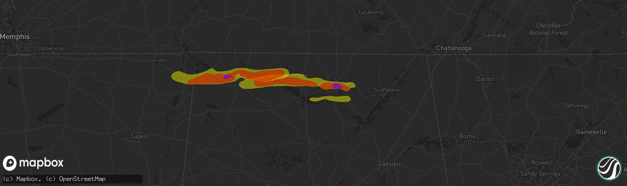
Hail Map in Madison, AL on May 20, 2025
The weather event in Madison, AL on May 20, 2025 includes Hail, Wind, and Tornado maps. 14 states and 787 cities were impacted and suffered possible damage. The total estimated number of properties impacted is 21,024.
Hail
Wind
Tornado
21,024
Estimated number of impacted properties by a 1.00" hail or larger5,132
Estimated number of impacted properties by a 1.75" hail or larger0
Estimated number of impacted properties by a 2.50" hail or largerStorm reports in Madison, AL
Madison, AL
| Date | Description |
|---|---|
| 05/20/20256:55 PM CDT | Report from mping: quarter |
| 05/20/20256:51 PM CDT | Report from mping: quarter |
| 05/20/20256:48 PM CDT | Spotter reported half dollar size hail at the lowes on highway 7 |
| 05/20/20256:48 PM CDT | Spotter reported half dollar size hail at the lowes on highway 73. |
| 05/20/20256:48 PM CDT | Half dollar hail reported on hwy 72 near lowes in madison. |
| 05/20/20256:45 PM CDT | Report from mping: quarter |
| 05/20/20256:45 PM CDT | Report from mping: quarter |
| 05/20/20256:44 PM CDT | Quarter sized hail reported on sullivan st in madison. |
| 05/20/20256:40 PM CDT | Tree through a house in the area of wedgewood terrace road and nick davis. Time estimated by radar. |
| 05/20/20256:40 PM CDT | Quarter size hail reported at shelton rd and madison blvd. |
| 05/20/20256:40 PM CDT | Tree down on house on glenmore dr. |
| 05/20/20256:31 PM CDT | Public report of a tornado with pictures of multiple trees uprooted... Snapped... And at least one tree on a structure on markum lane. |
| 05/20/20256:31 PM CDT | Roof torn off of a two story home as well as significant damage to roofs and walls of surrounding houses. |
| 05/20/20256:30 PM CDT | Numerous trees down near west madison elementary school and the sage trails apartments on wall-triana highway in madison. |
| 05/20/20256:20 PM CDT | Storm chaser video confirmation of tornado. |
| 05/19/20257:12 PM CDT | Report from mping: half dollar |
| 05/19/20257:10 PM CDT | Quarter sized hail reported in triana. Time estimated from radar. |
All States Impacted by Hail Map on May 20, 2025
All Cities Impacted by Hail Map on May 20, 2025
- Ostrander, MN
- Wykoff, MN
- Le Roy, MN
- Spring Valley, MN
- Carrollton, TX
- Plano, TX
- Garland, TX
- Addison, TX
- Grand Prairie, TX
- Dallas, TX
- Bedford, TX
- Coppell, TX
- Grapevine, TX
- Euless, TX
- Arlington, TX
- Hurst, TX
- Naval Air Station Jrb, TX
- North Richland Hills, TX
- Irving, TX
- Haltom City, TX
- Fort Worth, TX
- Richardson, TX
- Colleyville, TX
- Crystal City, TX
- Cotulla, TX
- Dilley, TX
- Pearsall, TX
- Asherton, TX
- Charlotte, TX
- Floresville, TX
- Jourdanton, TX
- Stockdale, TX
- Encinal, TX
- Pleasanton, TX
- Bethel Springs, TN
- Selmer, TN
- Adamsville, TN
- Gillett, TX
- Waterloo, AL
- Jacksonville, IL
- Winchester, IL
- Murrayville, IL
- Sheridan, AR
- Alexander, IL
- Jefferson, AR
- Redfield, AR
- White Hall, AR
- Woodson, IL
- Ashland, IL
- Sherrill, AR
- England, AR
- Tucker, AR
- Crab Orchard, TN
- Rockwood, TN
- Oakdale, TN
- Lonoke, AR
- Carlisle, AR
- Batesville, MS
- Pleasant Plains, IL
- Harriman, TN
- Gable, SC
- Carthage, AR
- Franklin, IL
- New Berlin, IL
- Grandin, MO
- Poplar Bluff, MO
- Parma, MO
- Lilbourn, MO
- Catron, MO
- Tallula, IL
- Hazen, AR
- De Valls Bluff, AR
- Waverly, IL
- Biscoe, AR
- McCrory, AR
- Stuttgart, AR
- Wabbaseka, AR
- Humnoke, AR
- Humphrey, AR
- Pulaski, TN
- New Zion, SC
- Sardis, MS
- Rison, AR
- Roodhouse, IL
- Loami, IL
- Oxford, MS
- Abbeville, MS
- Springfield, IL
- Marked Tree, AR
- Wynne, AR
- Turbeville, SC
- Petersburg, IL
- Altheimer, AR
- Fordyce, AR
- Huron, TN
- Lexington, TN
- Beech Bluff, TN
- Lake City, SC
- Cades, SC
- Wildersville, TN
- Williamsville, MO
- Como, MS
- Tyronza, AR
- Potts Camp, MS
- Darden, TN
- Parsons, TN
- New Edinburg, AR
- Pamplico, SC
- Sikeston, MO
- Lepanto, AR
- Dyess, AR
- Kingsland, AR
- New Madrid, MO
- Chatham, IL
- Waterford, MS
- Holly Springs, MS
- Cantrall, IL
- Caraway, AR
- Manila, AR
- Matthews, MO
- Holladay, TN
- Thaxton, MS
- Etta, MS
- Sherman, IL
- Almyra, AR
- Riverton, IL
- Dawson, IL
- Pekin, IL
- Peoria, IL
- East Peoria, IL
- Creve Coeur, IL
- Charleston, MO
- Louann, AR
- Wilmar, AR
- Casscoe, AR
- Star City, AR
- Parkin, AR
- Colt, AR
- Tiptonville, TN
- Ridgely, TN
- Gresham, SC
- Hayti, MO
- Williamsville, IL
- Athens, IL
- Elkhart, IL
- Johnsonville, SC
- Bertrand, MO
- Osceola, AR
- Centerville, TN
- Sugar Tree, TN
- Lobelville, TN
- Waverly, TN
- Linden, TN
- Buffalo, IL
- Grady, AR
- Dumas, AR
- Hampton, AR
- Forrest City, AR
- Joiner, AR
- Wilson, AR
- East Prairie, MO
- Ringgold, LA
- De Witt, AR
- Crocketts Bluff, AR
- Keiser, AR
- Mansfield, LA
- Roe, AR
- Myrtle, MS
- Dubach, LA
- Timmonsville, SC
- Hornbeak, TN
- Paxton, IL
- Ludlow, IL
- Rantoul, IL
- Mount Pulaski, IL
- Illiopolis, IL
- Jersey, AR
- Hermitage, AR
- Banks, AR
- Coushatta, LA
- Wickliffe, KY
- Barlow, KY
- Lincoln, IL
- Beason, IL
- Gibsland, LA
- Dubberly, LA
- Saint Charles, AR
- Henning, TN
- Union City, TN
- Rives, TN
- Troy, TN
- Latham, IL
- Jamestown, LA
- Hurricane Mills, TN
- Only, TN
- New Albany, MS
- Blue Mountain, MS
- Hemingway, SC
- Heflin, LA
- Warrensburg, IL
- Maroa, IL
- Nunnelly, TN
- Trimble, TN
- Kenton, TN
- Lynchburg, SC
- Olanta, SC
- Winchester, TN
- Estill Springs, TN
- Tullahoma, TN
- Holly Grove, AR
- Ethel, AR
- Dumas, MS
- Martin, TN
- Sharon, TN
- Poplar Grove, AR
- Marvell, AR
- Santa Fe, TN
- Williamsport, TN
- Pickens, AR
- Morristown, TN
- Booneville, MS
- Ripley, MS
- Chestnut, IL
- Luxora, AR
- Decatur, IL
- Rienzi, MS
- Waynesville, IL
- Kenney, IL
- Atlanta, IL
- Clinton, IL
- Bon Aqua, TN
- Lyles, TN
- Mohawk, TN
- Clarendon, AR
- Elaine, AR
- Lexa, AR
- Helena, AR
- Monticello, AR
- Decherd, TN
- Jackson, TN
- Midway, TN
- Fountain Hill, AR
- Hamburg, AR
- Hillsboro, TN
- Russellville, TN
- Bybee, TN
- Cedar Grove, TN
- Downsville, LA
- Duck River, TN
- Ashland, LA
- Saline, LA
- Choudrant, LA
- Farmerville, LA
- Whitesburg, TN
- Primm Springs, TN
- South Fulton, TN
- Oreana, IL
- Franklin, TN
- Baldwyn, MS
- Mosheim, TN
- Greeneville, TN
- Paducah, KY
- Smithland, KY
- Ledbetter, KY
- Brookport, IL
- Calvert City, KY
- Eddyville, KY
- Kuttawa, KY
- Grand Rivers, KY
- Tiline, KY
- Marion, KY
- Gilbertsville, KY
- Benton, KY
- Symsonia, KY
- Dickson, TN
- Fairview, TN
- Iuka, MS
- Friars Point, MS
- Coahoma, MS
- Dundee, MS
- Clarksdale, MS
- Palmersville, TN
- Dresden, TN
- Cherry Valley, AR
- Harrisburg, AR
- Trumann, AR
- Huntingdon, TN
- Yuma, TN
- Paris, TN
- Argenta, IL
- Cisco, IL
- Loda, IL
- Hickory Ridge, AR
- Tishomingo, MS
- Goldonna, LA
- Earle, AR
- Burnsville, MS
- Millington, TN
- Tillar, AR
- Drummonds, TN
- Crossett, AR
- Glen, MS
- Cherokee, AL
- Sterlington, LA
- Weldon, IL
- De Land, IL
- Monticello, IL
- Dodson, LA
- Winnfield, LA
- Columbia, TN
- Puryear, TN
- Hazel, KY
- Thompsons Station, TN
- Murray, KY
- New Concord, KY
- Buchanan, TN
- Spring Hill, TN
- Buena Vista, TN
- Westport, TN
- Sledge, MS
- Marks, MS
- Cottage Grove, TN
- Mahomet, IL
- Mansfield, IL
- White Heath, IL
- Montrose, AR
- Castor, LA
- Camden, TN
- Gibson City, IL
- Afton, TN
- Foosland, IL
- Lawrenceburg, TN
- Summertown, TN
- Fisher, IL
- Scotts Hill, TN
- Watson, AR
- Pelham, TN
- Tracy City, TN
- Dover, TN
- Monteagle, TN
- Dewey, IL
- Buckley, IL
- Ogden, IL
- Saint Joseph, IL
- Homer, IL
- Fithian, IL
- Seymour, IL
- College Grove, TN
- Champaign, IL
- Arrington, TN
- Nolensville, TN
- Sidney, IL
- Penfield, IL
- Gifford, IL
- Lebanon, VA
- Limestone, TN
- Chuckey, TN
- Mount Pleasant, TN
- Brentwood, TN
- Dayton, TX
- Liberty, TX
- Urbana, IL
- Dewitt, IL
- Monroe, LA
- Palmer, TN
- Whitwell, TN
- Armstrong, IL
- Telford, TN
- Jonesborough, TN
- Dunlap, TN
- Brownsville, TN
- Bells, TN
- Denmark, TN
- Oakfield, TN
- Medina, TN
- Culleoka, TN
- Tuscumbia, AL
- Florence, AL
- Muscle Shoals, AL
- Sheffield, AL
- Hopkinsville, KY
- Rankin, IL
- New Johnsonville, TN
- Lyon, MS
- Thomasboro, IL
- Antioch, TN
- Nashville, TN
- Campti, LA
- Madisonville, KY
- Earlington, KY
- Dawson Springs, KY
- Portland, AR
- Killen, AL
- Olla, LA
- Sikes, LA
- Bulls Gap, TN
- Clarksville, TN
- Smyrna, TN
- Murfreesboro, TN
- Saybrook, IL
- Bellflower, IL
- Potomac, IL
- Collison, IL
- Mortons Gap, KY
- White Plains, KY
- Eudora, AR
- Lake Village, AR
- Elkton, KY
- Russellville, AL
- Crenshaw, MS
- Leighton, AL
- Devers, TX
- Savoy, IL
- Greenville, KY
- Hull, TX
- Beulah, MS
- Rockvale, TN
- La Vergne, TN
- Town Creek, AL
- Danville, IL
- Rogersville, AL
- Chapel Hill, TN
- Lewisburg, TN
- Auburn, KY
- Woodburn, KY
- Rossville, IL
- Alvin, IL
- Henning, IL
- Eagleville, TN
- Iron City, TN
- Saint Joseph, TN
- Central City, KY
- Bremen, KY
- Courtland, AL
- Red Bay, AL
- Franklin, KY
- Lambert, MS
- McEwen, TN
- Unionville, TN
- Athens, AL
- Lascassas, TN
- Auburntown, TN
- Milton, TN
- Williamsport, IN
- Beaumont, TX
- Hollandale, MS
- Bismarck, IL
- Bowling Green, KY
- Greenville, MS
- Rockfield, KY
- Russellville, KY
- Alvaton, KY
- Boyle, MS
- Oakwood, IL
- Bondville, IL
- Bell Buckle, TN
- University, MS
- Taylor, MS
- Hillsboro, AL
- Pope, MS
- Courtland, MS
- Christiana, TN
- Elkmont, AL
- West Lebanon, IN
- Readyville, TN
- Kingston Springs, TN
- Kelly, LA
- Shaw, MS
- Doddsville, MS
- Ruleville, MS
- Cleveland, MS
- Gaffney, SC
- Cowpens, SC
- Graham, KY
- Philo, IL
- Soddy Daisy, TN
- Birchwood, TN
- Sale Creek, TN
- Bradyville, TN
- Beechgrove, TN
- Woodbury, TN
- Burns, TN
- Chatham, MS
- Warren, TX
- Water Valley, MS
- Liberty, TN
- Dowelltown, TN
- Adams, TN
- Smithville, TN
- Decatur, TN
- Glen Allan, MS
- Tullos, LA
- Perrysville, IN
- Covington, IN
- Tanner, AL
- Madison, AL
- Athens, TN
- Calhoun, TN
- Cape Girardeau, MO
- Rolling Fork, MS
- Anguilla, MS
- Veedersburg, IN
- Scottsville, KY
- Adolphus, KY
- Lebanon, TN
- Watertown, TN
- Shelbyville, TN
- Morrison, TN
- Mcminnville, TN
- Schlater, MS
- Belzoni, MS
- Pontotoc, MS
- Paris, MS
- Georgetown, LA
- Harvest, AL
- Huntsville, AL
- Manchester, TN
- Fairmount, IL
- Atlanta, LA
- Austin, KY
- Fountain Run, KY
- Rock Island, TN
- Silver City, MS
- Louise, MS
- Trout, LA
- Elliott, IL
- Cissna Park, IL
- Banner, MS
- Greenwood, MS
- Moulton, AL
- Danville, AL
- Wartrace, TN
- Spencer, TN
- Doyle, TN
- Sparta, TN
- Wingate, IN
- Randolph, MS
- Decatur, AL
- Hartselle, AL
- Charlotte, TN
- Mellott, IN
- Waynetown, IN
- Hillsboro, IN
- Glasgow, KY
- Etoile, KY
- Pegram, TN
- Morgantown, KY
- Caneyville, KY
- Quebeck, TN
- Sharon, SC
- Hickory Grove, SC
- Jena, LA
- Owens Cross Roads, AL
- Brownsboro, AL
- Gurley, AL
- Crossville, TN
- Pollock, LA
- Hamilton, AL
- Crawfordsville, IN
- Dry Prong, LA
- Somerville, AL
- Jonesville, LA
- Tremont, MS
- New Richmond, IN
- York, SC
- Millwood, KY
- Leitchfield, KY
- Vina, AL
- Alexandria, TN
- New Market, AL
- Walling, TN
- Trenton, AL
- Hollytree, AL
- Woodville, AL
- Valhermoso Springs, AL
- Laceys Spring, AL
- Tupelo, MS
- Shannon, MS
- Martinsville, IN
- Cloverdale, IN
- Monrovia, IN
- Trinity, AL
- Hackleburg, AL
- Newman, IL
- Allerton, IL
- Lester, AL
- Mooresville, IN
- Linden, IN
- Grandview, TN
- Plantersville, MS
- Goodman, MS
- Pickens, MS
- Chrisman, IL
- Yazoo City, MS
- Stilesville, IN
- Quincy, IN
- Graysville, TN
- Darlington, IN
- Nettleton, MS
- Scottsboro, AL
- Golden, MS
- Fulton, MS
- Stevenson, AL
- Hollywood, AL
- Benton, MS
- Hodges, AL
- Fackler, AL
- Frankfort, IN
- Mantachie, MS
- Camby, IN
- Lena, LA
- Colfax, LA
- Cloutierville, LA
- Paris, IL
- West Union, IL
- Amory, MS
- Flat Rock, AL
- Pisgah, AL
- New Hope, AL
- Grant, AL
- Milford, IL
- Watseka, IL
- Hoopeston, IL
- Sheldon, IL
- Wellington, IL
- Langston, AL
- Stockland, IL
- Ambia, IN
- Fowler, IN
- Royal, IL
- Boswell, IN
- Attica, IN
- Higdon, AL
- Smithville, MS
- Dayton, TN
- Mount Carmel, IL
- Saint Francisville, IL
- Indianapolis, IN
- Greenwood, IN
- Rising Fawn, GA
- Okolona, MS
- Brooklyn, IN
- Guild, TN
- Pikeville, TN
- Bryant, AL
- Trenton, GA
- Chattanooga, TN
- Signal Mountain, TN
- Section, AL
- Monterey, LA
- Greenwood Springs, MS
- Detroit, AL
- Bear Creek, AL
- Bentonia, MS
- Mooreville, MS
- Houlka, MS
- Pineville, LA
- Vaughan, MS
- Dutton, AL
- Terre Haute, IN
- Camden, MS
- Sallis, MS
- Vidalia, LA
- Tinsley, MS
- Satartia, MS
- Westville, IL
- Rosedale, IN
- Brazil, IN
- Alexandria, LA
- Boyce, LA
- Canton, MS
- West Terre Haute, IN
- West York, IL
- Fairland, IN
- Fountaintown, IN
- Shelbyville, IN
- Carthage, MS
- Whiteland, IN
- Center Point, LA
- Deville, LA
- Effie, LA
- Double Springs, AL
- Houston, AL
- Madison, MS
- Flora, MS
- Georgetown, IL
- Morristown, IN
- Eva, TN
- Carbon Hill, AL
- Townley, AL
- Big Sandy, TN
- Marksville, LA
- Oakman, AL
- Jasper, AL
- Lena, MS
- Brandon, MS
- Oak Ridge, TN
- Kingston, TN
- Lenoir City, TN
- Farragut, TN
- Knoxville, TN
- Clinton, TN
- Powell, TN
- Seymour, TN
- Sevierville, TN
- Morton, MS
- Pelahatchie, MS
- Cullman, AL
- Hanceville, AL
- Parrish, AL
- Moreauville, LA
- Forest Hill, LA
- Forest, MS
- Oneonta, AL
- Springville, AL
- Steele, AL
- Lecompte, LA
- Toney, AL
- Woodville, MS
- Angola, LA
- Saint Francisville, LA
- Pineville, KY
- Arjay, KY
- Kettle Island, KY
- Hulen, KY
- Stoney Fork, KY
- Miracle, KY
- Pathfork, KY
- Coldiron, KY
- Bledsoe, KY
- Wallins Creek, KY
- Dayhoit, KY
- Loyall, KY
- Harlan, KY
- Putney, KY
- Baxter, KY
- Totz, KY
- Ages Brookside, KY
- Evarts, KY
- Gordon, KY
- Big Laurel, KY
- Closplint, KY
- Cumberland, KY
- Benham, KY
- Lynch, KY
- Appalachia, VA
- Cheneyville, LA
- Ashville, AL
- Ragland, AL
- Ohatchee, AL
- Walnut Grove, MS
- Anniston, AL
- Heflin, AL
- Ranburne, AL
- Batchelor, LA
- Lettsworth, LA
- Woodworth, LA
- Ball, LA
- Sharpsburg, GA
- Fayetteville, GA
- Palmetto, GA
- Tyrone, GA
- Newnan, GA
- Whitesburg, GA
- Jonesboro, GA
- Peachtree City, GA
- Hampton, GA
- Riverdale, GA
- Forsyth, IL
- Locust Grove, GA
- Jenkinsburg, GA
- Jackson, GA
- Effingham, SC
- Forest Park, GA
- Rex, GA
- Morrow, GA
- Atlanta, GA
- Fairburn, GA
- Stockbridge, GA
- Bonaire, GA
- Kathleen, GA
- Bargersville, IN
- Franklin, IN
- West Newton, IN
- Greencastle, IN
- Dennis, MS
- Paint Rock, AL


