Hail Map in Georgia on May 20, 2025
The weather event in Georgia on May 20, 2025 includes Hail, Wind, and Tornado maps. 14 states and 787 cities were impacted and suffered possible damage. The total estimated number of properties impacted is 6,010.
Want more than just the map?
Turn this storm into a full workflow.
- Owner + property data so you know who to knock
- OnDemand branded weather history reports to win the "did we even have hail?" argument
- RoofTrace estimate so reps stop guessing numbers at the door
Bought this map? Upgrade within 7 days and we'll credit the $230. (10-15 min setup call)
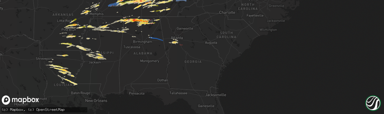
Hail
Wind
Tornado
6,010
Estimated number of impacted properties by a 1.00" hail or larger0
Estimated number of impacted properties by a 1.75" hail or larger0
Estimated number of impacted properties by a 2.50" hail or largerStorm reports in Georgia
Georgia
| Date | Description |
|---|---|
| 05/20/202510:40 AM CDT | Emergency manager relayed report of multiple trees and powerlines down near park street nw... Including a tree down on a home. |
| 05/20/20253:55 AM CDT | Georgia power website reported power outages on morr |
| 05/20/20253:55 AM CDT | Georgia power website reported power outages on morris calloway road due to a fallen tree. Time estimated by radar. |
| 05/20/20252:57 AM CDT | An ef1 tornado occurred along a 10.5 mile path starting in ne spalding county and ending in butts county near the city of jackson. Max winds 90 mph. |
| 05/20/20252:50 AM CDT | Emergency manager reported a down tre |
| 05/20/20252:50 AM CDT | Emergency manager reported a down tree on halls bridge road. Estimated location. |
| 05/20/20252:48 AM CDT | Emergency manager relayed report of a tree down on plaza drive. |
| 05/20/20252:42 AM CDT | Tree reported down at the intersection of amelia rd and apple rd. |
| 05/20/20252:41 AM CDT | Roof taken off a barn near the intersection of johnson rd and hwy 155. |
| 05/20/20252:24 AM CDT | Emergency manager relayed report of a down tree near vernon ferry road and bailey road. |
| 05/20/20251:56 AM CDT | Public report of 1.5 inch hail in the river crest neighborhood in tyrone. |
| 05/20/20251:00 AM CDT | Emergency manager relayed a report of a tree down across the road near capps ferry road and brecken drive. The downed tree caused an accident... With no injuries. |
| 05/20/202512:55 AM CDT | Broadcast media report of trees down on vehicles along stone rd in southwest atlanta. Radar signatures suggest that a downburst was the likely cause. |
| 05/20/202512:54 AM CDT | Emergency manager reported a downed tree in the 2900 block of tommy dillard road. |
| 05/20/202512:53 AM CDT | Report of a tree in the roadway near the intersection of bethesda church rd and horton rd. |
| 05/20/202512:51 AM CDT | Report of a tree down in the roadway near the intersection of lambert lane and lovvorn road. |
| 05/20/202512:42 AM CDT | Emergency manager reported down tree in the 2000 block of us hwy 78 |
| 05/20/202512:30 AM CDT | Emergency manager relayed a report of a tree down on a powerline near campbellton street and rose circle. |
| 05/20/202512:24 AM CDT | The emergency manager relayed a report of a tree down on the road in the 4000 block of ga highway 5. |
| 05/20/202512:24 AM CDT | The emergency manager relayed a report of a downed tree across pocahontas drive. |
| 05/20/202512:18 AM CDT | Emergency manager relayed a report of a downed tree... Partially blocking the 5000 block of liberty road. |
| 05/19/202511:48 PM CDT | Ham radio operator reported a tree down at a residence near pilgrim mill road and faa road. |
| 05/19/202511:38 PM CDT | Trees have fallen on 2 different homes near the intersection of dena drive and mills wood run. |
| 05/19/202511:15 PM CDT | Public reported a snapped tree and a damaged shade structure at a location off flatbottom road. |
| 05/19/202511:12 PM CDT | Emergency manager reported powerlines down along cut off road. |
| 05/19/202511:08 PM CDT | Several trees down near hwy 140 and garland mountain road. |
| 05/19/202511:08 PM CDT | Tree reported down on a power line on mckelvey dr. |
| 05/19/202511:05 PM CDT | Emergency manager reported several trees down at county line road no. 2 ne and folsom glade road nw. |
| 05/19/202510:50 PM CDT | Emergency manager relayed report of a tree down along county line road no 2. |
| 05/19/202510:48 PM CDT | Emergency manager reported trees and powerlines down in the 1000 block of cassville pine log road in rydal. |
| 05/19/202510:48 PM CDT | Emergency manager relayed report of a tree down at clear creek road and pleasant valley road. |
| 05/19/202510:48 PM CDT | Emergency manager reported down tree at richards road and luke quarles road. |
| 05/19/202510:47 PM CDT | Emergency manager relayed report of a tree down near bible baptist road and yukon trace. |
| 05/19/202510:45 PM CDT | A local report indicates 59 MPH wind near 1 ENE Adairsville |
| 05/19/202510:45 PM CDT | Multiple trees and powerlines down near the intersection of windy hill road se and folsom road. Possible tornado. |
| 05/19/202510:42 PM CDT | Emergency manager reported several trees and powerlines down at tom jones road nw and kingston highway |
| 05/19/202510:40 PM CDT | Emergency manager relayed report of powerlines down on george street nw. |
| 05/19/202510:36 PM CDT | Emergency manager reported trees and powerlines down at westover drive nw and twin bridges road. |
| 05/19/202510:05 PM CDT | Report of trees and possible power lines down along long branch road in lumpkin county. |
| 05/19/202510:05 PM CDT | Report of tree damage and possible power line issues along cloudland rd in lumpkin county... Ga. |
| 05/19/202510:00 PM CDT | Report of tree damage and possible power line damage along summerour rd in lumpkin county. |
| 05/19/202510:00 PM CDT | 1 to 2 trees down and powerlines down along edison street. |
| 05/19/202510:00 PM CDT | Tree on a home near the intersection of ridge street and allgood street. |
| 05/19/20259:57 PM CDT | Downed tree near the intersection of deforest avenue and allgood street. |
| 05/19/20259:55 PM CDT | Tree in the road at haig mill lake road and north bypass blocking the southbound lane. |
| 05/19/20259:50 PM CDT | Tree on a powerline along peach orchard road near menlo. |
| 05/19/20259:50 PM CDT | Tree down near north main st and wardlaw st in lafayette... Ga. |
| 05/19/20259:48 PM CDT | Tree down near the intersection of hwy 151 and hwy 27. |
| 05/19/20259:45 PM CDT | Large tree across the road near the intersection of highway 157 and valley view ranch road. |
| 05/19/20259:45 PM CDT | Tree down near hwy 57 and sunshine trail. |
| 05/19/20259:26 PM CDT | Multiple trees along houston valley road. |
| 05/19/20259:15 PM CDT | Tree down near the intersection of hwy 136 and south dicks creek rd. |
| 05/19/20259:06 PM CDT | The emergency manager relayed a report of a tree in the road on kenny lane. |
| 05/19/20259:05 PM CDT | Report of a downed tree from local em along wood station rd. |
| 05/19/20259:00 PM CDT | The emergency manager relayed a report of a tree in a roadway in the 400 block of wood yates road. |
| 05/19/20258:54 PM CDT | The emergency manager relayed a report of a tree down in the road at w nickajack road. Estimated location. |
| 05/19/20258:36 PM CDT | Emergency manager relayed a report of a tree down across the road near rolling hills drive and post oak road. |
| 05/19/20258:36 PM CDT | The emergency manager relayed a report of a tree down in the road near lafayette road and brotherton road. |
| 05/19/20258:30 PM CDT | Tree down near west 12th st and fouts way in chickamauga. |
All States Impacted by Hail Map on May 20, 2025
Cities Impacted by Hail Map on May 20, 2025
- Ostrander, MN
- Wykoff, MN
- Le Roy, MN
- Spring Valley, MN
- Carrollton, TX
- Plano, TX
- Garland, TX
- Addison, TX
- Grand Prairie, TX
- Dallas, TX
- Bedford, TX
- Coppell, TX
- Grapevine, TX
- Euless, TX
- Arlington, TX
- Hurst, TX
- Naval Air Station Jrb, TX
- North Richland Hills, TX
- Irving, TX
- Haltom City, TX
- Fort Worth, TX
- Richardson, TX
- Colleyville, TX
- Crystal City, TX
- Cotulla, TX
- Dilley, TX
- Pearsall, TX
- Asherton, TX
- Charlotte, TX
- Floresville, TX
- Jourdanton, TX
- Stockdale, TX
- Encinal, TX
- Pleasanton, TX
- Bethel Springs, TN
- Selmer, TN
- Adamsville, TN
- Gillett, TX
- Waterloo, AL
- Jacksonville, IL
- Winchester, IL
- Murrayville, IL
- Sheridan, AR
- Alexander, IL
- Jefferson, AR
- Redfield, AR
- White Hall, AR
- Woodson, IL
- Ashland, IL
- Sherrill, AR
- England, AR
- Tucker, AR
- Crab Orchard, TN
- Rockwood, TN
- Oakdale, TN
- Lonoke, AR
- Carlisle, AR
- Batesville, MS
- Pleasant Plains, IL
- Harriman, TN
- Gable, SC
- Carthage, AR
- Franklin, IL
- New Berlin, IL
- Grandin, MO
- Poplar Bluff, MO
- Parma, MO
- Lilbourn, MO
- Catron, MO
- Tallula, IL
- Hazen, AR
- De Valls Bluff, AR
- Waverly, IL
- Biscoe, AR
- McCrory, AR
- Stuttgart, AR
- Wabbaseka, AR
- Humnoke, AR
- Humphrey, AR
- Pulaski, TN
- New Zion, SC
- Sardis, MS
- Rison, AR
- Roodhouse, IL
- Loami, IL
- Oxford, MS
- Abbeville, MS
- Springfield, IL
- Marked Tree, AR
- Wynne, AR
- Turbeville, SC
- Petersburg, IL
- Altheimer, AR
- Fordyce, AR
- Huron, TN
- Lexington, TN
- Beech Bluff, TN
- Lake City, SC
- Cades, SC
- Wildersville, TN
- Williamsville, MO
- Como, MS
- Tyronza, AR
- Potts Camp, MS
- Darden, TN
- Parsons, TN
- New Edinburg, AR
- Pamplico, SC
- Sikeston, MO
- Lepanto, AR
- Dyess, AR
- Kingsland, AR
- New Madrid, MO
- Chatham, IL
- Waterford, MS
- Holly Springs, MS
- Cantrall, IL
- Caraway, AR
- Manila, AR
- Matthews, MO
- Holladay, TN
- Thaxton, MS
- Etta, MS
- Sherman, IL
- Almyra, AR
- Riverton, IL
- Dawson, IL
- Pekin, IL
- Peoria, IL
- East Peoria, IL
- Creve Coeur, IL
- Charleston, MO
- Louann, AR
- Wilmar, AR
- Casscoe, AR
- Star City, AR
- Parkin, AR
- Colt, AR
- Tiptonville, TN
- Ridgely, TN
- Gresham, SC
- Hayti, MO
- Williamsville, IL
- Athens, IL
- Elkhart, IL
- Johnsonville, SC
- Bertrand, MO
- Osceola, AR
- Centerville, TN
- Sugar Tree, TN
- Lobelville, TN
- Waverly, TN
- Linden, TN
- Buffalo, IL
- Grady, AR
- Dumas, AR
- Hampton, AR
- Forrest City, AR
- Joiner, AR
- Wilson, AR
- East Prairie, MO
- Ringgold, LA
- De Witt, AR
- Crocketts Bluff, AR
- Keiser, AR
- Mansfield, LA
- Roe, AR
- Myrtle, MS
- Dubach, LA
- Timmonsville, SC
- Hornbeak, TN
- Paxton, IL
- Ludlow, IL
- Rantoul, IL
- Mount Pulaski, IL
- Illiopolis, IL
- Jersey, AR
- Hermitage, AR
- Banks, AR
- Coushatta, LA
- Wickliffe, KY
- Barlow, KY
- Lincoln, IL
- Beason, IL
- Gibsland, LA
- Dubberly, LA
- Saint Charles, AR
- Henning, TN
- Union City, TN
- Rives, TN
- Troy, TN
- Latham, IL
- Jamestown, LA
- Hurricane Mills, TN
- Only, TN
- New Albany, MS
- Blue Mountain, MS
- Hemingway, SC
- Heflin, LA
- Warrensburg, IL
- Maroa, IL
- Nunnelly, TN
- Trimble, TN
- Kenton, TN
- Lynchburg, SC
- Olanta, SC
- Winchester, TN
- Estill Springs, TN
- Tullahoma, TN
- Holly Grove, AR
- Ethel, AR
- Dumas, MS
- Martin, TN
- Sharon, TN
- Poplar Grove, AR
- Marvell, AR
- Santa Fe, TN
- Williamsport, TN
- Pickens, AR
- Morristown, TN
- Booneville, MS
- Ripley, MS
- Chestnut, IL
- Luxora, AR
- Decatur, IL
- Rienzi, MS
- Waynesville, IL
- Kenney, IL
- Atlanta, IL
- Clinton, IL
- Bon Aqua, TN
- Lyles, TN
- Mohawk, TN
- Clarendon, AR
- Elaine, AR
- Lexa, AR
- Helena, AR
- Monticello, AR
- Decherd, TN
- Jackson, TN
- Midway, TN
- Fountain Hill, AR
- Hamburg, AR
- Hillsboro, TN
- Russellville, TN
- Bybee, TN
- Cedar Grove, TN
- Downsville, LA
- Duck River, TN
- Ashland, LA
- Saline, LA
- Choudrant, LA
- Farmerville, LA
- Whitesburg, TN
- Primm Springs, TN
- South Fulton, TN
- Oreana, IL
- Franklin, TN
- Baldwyn, MS
- Mosheim, TN
- Greeneville, TN
- Paducah, KY
- Smithland, KY
- Ledbetter, KY
- Brookport, IL
- Calvert City, KY
- Eddyville, KY
- Kuttawa, KY
- Grand Rivers, KY
- Tiline, KY
- Marion, KY
- Gilbertsville, KY
- Benton, KY
- Symsonia, KY
- Dickson, TN
- Fairview, TN
- Iuka, MS
- Friars Point, MS
- Coahoma, MS
- Dundee, MS
- Clarksdale, MS
- Palmersville, TN
- Dresden, TN
- Cherry Valley, AR
- Harrisburg, AR
- Trumann, AR
- Huntingdon, TN
- Yuma, TN
- Paris, TN
- Argenta, IL
- Cisco, IL
- Loda, IL
- Hickory Ridge, AR
- Tishomingo, MS
- Goldonna, LA
- Earle, AR
- Burnsville, MS
- Millington, TN
- Tillar, AR
- Drummonds, TN
- Crossett, AR
- Glen, MS
- Cherokee, AL
- Sterlington, LA
- Weldon, IL
- De Land, IL
- Monticello, IL
- Dodson, LA
- Winnfield, LA
- Columbia, TN
- Puryear, TN
- Hazel, KY
- Thompsons Station, TN
- Murray, KY
- New Concord, KY
- Buchanan, TN
- Spring Hill, TN
- Buena Vista, TN
- Westport, TN
- Sledge, MS
- Marks, MS
- Cottage Grove, TN
- Mahomet, IL
- Mansfield, IL
- White Heath, IL
- Montrose, AR
- Castor, LA
- Camden, TN
- Gibson City, IL
- Afton, TN
- Foosland, IL
- Lawrenceburg, TN
- Summertown, TN
- Fisher, IL
- Scotts Hill, TN
- Watson, AR
- Pelham, TN
- Tracy City, TN
- Dover, TN
- Monteagle, TN
- Dewey, IL
- Buckley, IL
- Ogden, IL
- Saint Joseph, IL
- Homer, IL
- Fithian, IL
- Seymour, IL
- College Grove, TN
- Champaign, IL
- Arrington, TN
- Nolensville, TN
- Sidney, IL
- Penfield, IL
- Gifford, IL
- Lebanon, VA
- Limestone, TN
- Chuckey, TN
- Mount Pleasant, TN
- Brentwood, TN
- Dayton, TX
- Liberty, TX
- Urbana, IL
- Dewitt, IL
- Monroe, LA
- Palmer, TN
- Whitwell, TN
- Armstrong, IL
- Telford, TN
- Jonesborough, TN
- Dunlap, TN
- Brownsville, TN
- Bells, TN
- Denmark, TN
- Oakfield, TN
- Medina, TN
- Culleoka, TN
- Tuscumbia, AL
- Florence, AL
- Muscle Shoals, AL
- Sheffield, AL
- Hopkinsville, KY
- Rankin, IL
- New Johnsonville, TN
- Lyon, MS
- Thomasboro, IL
- Antioch, TN
- Nashville, TN
- Campti, LA
- Madisonville, KY
- Earlington, KY
- Dawson Springs, KY
- Portland, AR
- Killen, AL
- Olla, LA
- Sikes, LA
- Bulls Gap, TN
- Clarksville, TN
- Smyrna, TN
- Murfreesboro, TN
- Saybrook, IL
- Bellflower, IL
- Potomac, IL
- Collison, IL
- Mortons Gap, KY
- White Plains, KY
- Eudora, AR
- Lake Village, AR
- Elkton, KY
- Russellville, AL
- Crenshaw, MS
- Leighton, AL
- Devers, TX
- Savoy, IL
- Greenville, KY
- Hull, TX
- Beulah, MS
- Rockvale, TN
- La Vergne, TN
- Town Creek, AL
- Danville, IL
- Rogersville, AL
- Chapel Hill, TN
- Lewisburg, TN
- Auburn, KY
- Woodburn, KY
- Rossville, IL
- Alvin, IL
- Henning, IL
- Eagleville, TN
- Iron City, TN
- Saint Joseph, TN
- Central City, KY
- Bremen, KY
- Courtland, AL
- Red Bay, AL
- Franklin, KY
- Lambert, MS
- McEwen, TN
- Unionville, TN
- Athens, AL
- Lascassas, TN
- Auburntown, TN
- Milton, TN
- Williamsport, IN
- Beaumont, TX
- Hollandale, MS
- Bismarck, IL
- Bowling Green, KY
- Greenville, MS
- Rockfield, KY
- Russellville, KY
- Alvaton, KY
- Boyle, MS
- Oakwood, IL
- Bondville, IL
- Bell Buckle, TN
- University, MS
- Taylor, MS
- Hillsboro, AL
- Pope, MS
- Courtland, MS
- Christiana, TN
- Elkmont, AL
- West Lebanon, IN
- Readyville, TN
- Kingston Springs, TN
- Kelly, LA
- Shaw, MS
- Doddsville, MS
- Ruleville, MS
- Cleveland, MS
- Gaffney, SC
- Cowpens, SC
- Graham, KY
- Philo, IL
- Soddy Daisy, TN
- Birchwood, TN
- Sale Creek, TN
- Bradyville, TN
- Beechgrove, TN
- Woodbury, TN
- Burns, TN
- Chatham, MS
- Warren, TX
- Water Valley, MS
- Liberty, TN
- Dowelltown, TN
- Adams, TN
- Smithville, TN
- Decatur, TN
- Glen Allan, MS
- Tullos, LA
- Perrysville, IN
- Covington, IN
- Tanner, AL
- Madison, AL
- Athens, TN
- Calhoun, TN
- Cape Girardeau, MO
- Rolling Fork, MS
- Anguilla, MS
- Veedersburg, IN
- Scottsville, KY
- Adolphus, KY
- Lebanon, TN
- Watertown, TN
- Shelbyville, TN
- Morrison, TN
- Mcminnville, TN
- Schlater, MS
- Belzoni, MS
- Pontotoc, MS
- Paris, MS
- Georgetown, LA
- Harvest, AL
- Huntsville, AL
- Manchester, TN
- Fairmount, IL
- Atlanta, LA
- Austin, KY
- Fountain Run, KY
- Rock Island, TN
- Silver City, MS
- Louise, MS
- Trout, LA
- Elliott, IL
- Cissna Park, IL
- Banner, MS
- Greenwood, MS
- Moulton, AL
- Danville, AL
- Wartrace, TN
- Spencer, TN
- Doyle, TN
- Sparta, TN
- Wingate, IN
- Randolph, MS
- Decatur, AL
- Hartselle, AL
- Charlotte, TN
- Mellott, IN
- Waynetown, IN
- Hillsboro, IN
- Glasgow, KY
- Etoile, KY
- Pegram, TN
- Morgantown, KY
- Caneyville, KY
- Quebeck, TN
- Sharon, SC
- Hickory Grove, SC
- Jena, LA
- Owens Cross Roads, AL
- Brownsboro, AL
- Gurley, AL
- Crossville, TN
- Pollock, LA
- Hamilton, AL
- Crawfordsville, IN
- Dry Prong, LA
- Somerville, AL
- Jonesville, LA
- Tremont, MS
- New Richmond, IN
- York, SC
- Millwood, KY
- Leitchfield, KY
- Vina, AL
- Alexandria, TN
- New Market, AL
- Walling, TN
- Trenton, AL
- Hollytree, AL
- Woodville, AL
- Valhermoso Springs, AL
- Laceys Spring, AL
- Tupelo, MS
- Shannon, MS
- Martinsville, IN
- Cloverdale, IN
- Monrovia, IN
- Trinity, AL
- Hackleburg, AL
- Newman, IL
- Allerton, IL
- Lester, AL
- Mooresville, IN
- Linden, IN
- Grandview, TN
- Plantersville, MS
- Goodman, MS
- Pickens, MS
- Chrisman, IL
- Yazoo City, MS
- Stilesville, IN
- Quincy, IN
- Graysville, TN
- Darlington, IN
- Nettleton, MS
- Scottsboro, AL
- Golden, MS
- Fulton, MS
- Stevenson, AL
- Hollywood, AL
- Benton, MS
- Hodges, AL
- Fackler, AL
- Frankfort, IN
- Mantachie, MS
- Camby, IN
- Lena, LA
- Colfax, LA
- Cloutierville, LA
- Paris, IL
- West Union, IL
- Amory, MS
- Flat Rock, AL
- Pisgah, AL
- New Hope, AL
- Grant, AL
- Milford, IL
- Watseka, IL
- Hoopeston, IL
- Sheldon, IL
- Wellington, IL
- Langston, AL
- Stockland, IL
- Ambia, IN
- Fowler, IN
- Royal, IL
- Boswell, IN
- Attica, IN
- Higdon, AL
- Smithville, MS
- Dayton, TN
- Mount Carmel, IL
- Saint Francisville, IL
- Indianapolis, IN
- Greenwood, IN
- Rising Fawn, GA
- Okolona, MS
- Brooklyn, IN
- Guild, TN
- Pikeville, TN
- Bryant, AL
- Trenton, GA
- Chattanooga, TN
- Signal Mountain, TN
- Section, AL
- Monterey, LA
- Greenwood Springs, MS
- Detroit, AL
- Bear Creek, AL
- Bentonia, MS
- Mooreville, MS
- Houlka, MS
- Pineville, LA
- Vaughan, MS
- Dutton, AL
- Terre Haute, IN
- Camden, MS
- Sallis, MS
- Vidalia, LA
- Tinsley, MS
- Satartia, MS
- Westville, IL
- Rosedale, IN
- Brazil, IN
- Alexandria, LA
- Boyce, LA
- Canton, MS
- West Terre Haute, IN
- West York, IL
- Fairland, IN
- Fountaintown, IN
- Shelbyville, IN
- Carthage, MS
- Whiteland, IN
- Center Point, LA
- Deville, LA
- Effie, LA
- Double Springs, AL
- Houston, AL
- Madison, MS
- Flora, MS
- Georgetown, IL
- Morristown, IN
- Eva, TN
- Carbon Hill, AL
- Townley, AL
- Big Sandy, TN
- Marksville, LA
- Oakman, AL
- Jasper, AL
- Lena, MS
- Brandon, MS
- Oak Ridge, TN
- Kingston, TN
- Lenoir City, TN
- Farragut, TN
- Knoxville, TN
- Clinton, TN
- Powell, TN
- Seymour, TN
- Sevierville, TN
- Morton, MS
- Pelahatchie, MS
- Cullman, AL
- Hanceville, AL
- Parrish, AL
- Moreauville, LA
- Forest Hill, LA
- Forest, MS
- Oneonta, AL
- Springville, AL
- Steele, AL
- Lecompte, LA
- Toney, AL
- Woodville, MS
- Angola, LA
- Saint Francisville, LA
- Pineville, KY
- Arjay, KY
- Kettle Island, KY
- Hulen, KY
- Stoney Fork, KY
- Miracle, KY
- Pathfork, KY
- Coldiron, KY
- Bledsoe, KY
- Wallins Creek, KY
- Dayhoit, KY
- Loyall, KY
- Harlan, KY
- Putney, KY
- Baxter, KY
- Totz, KY
- Ages Brookside, KY
- Evarts, KY
- Gordon, KY
- Big Laurel, KY
- Closplint, KY
- Cumberland, KY
- Benham, KY
- Lynch, KY
- Appalachia, VA
- Cheneyville, LA
- Ashville, AL
- Ragland, AL
- Ohatchee, AL
- Walnut Grove, MS
- Anniston, AL
- Heflin, AL
- Ranburne, AL
- Batchelor, LA
- Lettsworth, LA
- Woodworth, LA
- Ball, LA
- Sharpsburg, GA
- Fayetteville, GA
- Palmetto, GA
- Tyrone, GA
- Newnan, GA
- Whitesburg, GA
- Jonesboro, GA
- Peachtree City, GA
- Hampton, GA
- Riverdale, GA
- Forsyth, IL
- Locust Grove, GA
- Jenkinsburg, GA
- Jackson, GA
- Effingham, SC
- Forest Park, GA
- Rex, GA
- Morrow, GA
- Atlanta, GA
- Fairburn, GA
- Stockbridge, GA
- Bonaire, GA
- Kathleen, GA
- Bargersville, IN
- Franklin, IN
- West Newton, IN
- Greencastle, IN
- Dennis, MS
- Paint Rock, AL


