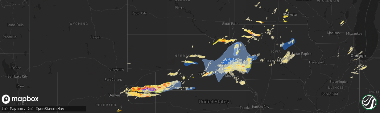
Hail Map in Nebraska on May 20, 2024
The weather event in Nebraska on May 20, 2024 includes Hail, Wind, and Tornado maps. 14 states and 770 cities were impacted and suffered possible damage. The total estimated number of properties impacted is 64,677.
Want more than just the map?
Turn this storm into a full workflow.
- Owner + property data so you know who to knock
- OnDemand branded weather history reports to win the "did we even have hail?" argument
- RoofTrace estimate so reps stop guessing numbers at the door
Bought this map? Upgrade within 7 days and we'll credit the $230. (10-15 min setup call)
Hail
Wind
Tornado
64,677
Estimated number of impacted properties by a 1.00" hail or larger32,214
Estimated number of impacted properties by a 1.75" hail or larger12
Estimated number of impacted properties by a 2.50" hail or largerStorm reports in Nebraska
Nebraska
| Date | Description |
|---|---|
| 05/20/20246:24 AM CDT | A local report indicates 1.00 inch wind near 1 WSW Omaha |
| 05/20/20246:19 AM CDT | A local report indicates 60 MPH wind near 1 WSW Omaha |
| 05/20/20246:07 AM CDT | A local report indicates 62 MPH wind near 3 ESE Tekamah |
| 05/20/20246:02 AM CDT | A local report indicates 1.00 inch wind near 2 W Omaha |
| 05/20/20246:00 AM CDT | A local report indicates 1.50 inch wind near 1 W Omaha |
| 05/20/20245:51 AM CDT | Delayed report: roof taken off shed. Several large trees blown over. Time estimated from radar. |
| 05/20/20245:45 AM CDT | Numerous large trees down across valley view estates and valley view golf course. Delayed report. |
| 05/20/20245:42 AM CDT | A local report indicates 1.25 inch wind near 3 SSW Bennington |
| 05/20/20245:40 AM CDT | A local report indicates 1.00 inch wind near 2 SE Elkhorn |
| 05/20/20245:39 AM CDT | Numerous outbuildings damaged. Trees uprooted and powerlines down. Time based on radar. |
| 05/20/20245:37 AM CDT | A local report indicates 1.50 inch wind near Bennington |
| 05/20/20245:36 AM CDT | A local report indicates 1.00 inch wind near 3 WNW Boys Town |
| 05/20/20245:36 AM CDT | Report from mping of quarter sized hail southeast of bennington. |
| 05/20/20245:33 AM CDT | 6 power poles down. Time based on radar. |
| 05/20/20245:33 AM CDT | Corrects previous tstm wnd dmg report to fix the time delayed report: roof taken off shed. Several large trees blown over. Time estimated from radar. |
| 05/20/20245:33 AM CDT | Report from mping of quarter sized hail south of bennington. |
| 05/20/20245:33 AM CDT | Report from mping of quarter sized hail on the northwest side of bennington. |
| 05/20/20245:30 AM CDT | Report from mping of golfball sized hail 3 miles south-southwest of bennington. |
| 05/20/20245:30 AM CDT | Report from mping of quarter sized hail 4 miles northeast of elkhorn. |
| 05/20/20245:30 AM CDT | A local report indicates 79 MPH wind near Howells |
| 05/20/20245:29 AM CDT | Report from mping of half dollar sized hail. |
| 05/20/20245:25 AM CDT | Several tree tops snapped. Also 4.50 rainfall. Time estimated from radar. |
| 05/20/20245:14 AM CDT | Numerous outbuildings have roofs off including a machine shed and 2 hog units. Numerous overturned pivots. Time based on radar. |
| 05/20/20245:06 AM CDT | Several center pivots overturned and multiple power poles snapped from the intersection of u.s. 81 and state highway 64 east to bellwood. Report time based on radar. |
| 05/20/20245:05 AM CDT | Multiple power poles snapped off on the northeast side of columbus. Tree damage around columbus as well. |
| 05/20/20244:56 AM CDT | A local report indicates 66 MPH wind near 3 WSW Fairmont |
| 05/20/20244:54 AM CDT | A local report indicates 74 MPH wind near 4 ESE Osceola |
| 05/20/20244:38 AM CDT | A local report indicates 65 MPH wind near 9 WNW Genoa |
| 05/20/20244:33 AM CDT | A local report indicates 64 MPH wind near 7 NNE Wolbach |
| 05/20/20244:33 AM CDT | . |
| 05/20/20244:29 AM CDT | Em sent photos of branches down and at least one tree. Time estimated from radar and nearby mesonet ob. |
| 05/20/20244:13 AM CDT | Corrects time on previous tstm wnd gst report from 7 nne wolbach. |
| 05/20/20244:07 AM CDT | A local report indicates 59 MPH wind near Grand Island Airport |
| 05/20/20243:21 AM CDT | A local report indicates 58 MPH wind near 3 NNW Alma |
| 05/20/20242:44 AM CDT | Delayed report of a downed tree branch 2.5 inches diameter from overnight line of storms. Time estimated from radar. |
| 05/20/20242:39 AM CDT | Report via social media. Time estimated from radar. |
| 05/20/20242:38 AM CDT | Set of metal bleachers at high school football field flipped upside down and moved into the middle of the football field. Caller estimates these are 30 feet wide by app |
| 05/20/20242:38 AM CDT | Picture of snapped tree and snapped tree limbs up to 1 foot in diameter. |
| 05/20/20241:17 AM CDT | Report and photo via social media of hail estimated from photo to be around the size of a tennis ball. Hail was reported to have varied in size. |
| 05/20/20241:15 AM CDT | Public report and photo via social media of hail in palisade; sizes estimated from photo ranging from approx. Half dollar size to around 2 inches in diameter. Time esti |
| 05/20/202412:55 AM CDT | Trained spotter reporting hail between the sizes of golf balls and hen eggs. |
| 05/20/202412:45 AM CDT | Golf ball size hail reported 14 miles nnw of stratton... Ne. Time estimated from radar. |
| 05/20/202412:41 AM CDT | Caller reported golf ball hail ongoing. |
| 05/20/202412:30 AM CDT | Report and photo via social media |
| 05/20/202412:12 AM CDT | Personal weather station in parks... Ne measured a wind gust of 91 mph. Report carport is gone and a camper was blown out of the carport. |
| 05/20/202412:07 AM CDT | Weatherunderground site knebenke10. Wind direction from the north-northeast. |
| 05/20/202412:00 AM CDT | Report and photos via social media of downed trees and damage to a barn and grain bin approx. 13 miles west of benkelman. Time estimated from radar. |
| 05/19/202411:54 PM CDT | Weatherlink site brunswig shop. |
| 05/19/202411:53 PM CDT | Weatherlink site brunswig shop. |
| 05/19/202411:50 PM CDT | Trees down on the northwest and southeast sides of town. |
| 05/19/202411:50 PM CDT | Corrects time on previous tstm wnd dmg report from 8 n haigler. Spotter reported uprooted trees and some building damage. |
| 05/19/202411:46 PM CDT | Report from mping: half dollar |
| 05/19/202411:25 PM CDT | 12 inch tree limb down and patio furniture blown about the yard. |
| 05/19/202411:15 PM CDT | A local report indicates 69 MPH wind near 4 NE Bennington |
| 05/19/202411:05 PM CDT | The wind was strong for about 30 minutes... Easily reaching speeds of 60 mph. |
| 05/19/202410:47 PM CDT | A local report indicates 71 MPH wind near 2 N Broken Bow |
| 05/19/202410:30 PM CDT | Lots of quarter to golf ball sized hail. Ground covered in hail. |
| 05/19/202410:30 PM CDT | Hail pea size to 2 inches in diameter. Hail damage to siding... Roofs... Windows... And vehicles. |
| 05/19/202410:26 PM CDT | Repor |
| 05/19/202410:26 PM CDT | Report from mping: half dollar |
| 05/19/202410:07 PM CDT | A local report indicates 65 MPH wind near 2 NNW Decatur |
| 05/19/202410:05 PM CDT | Social media. |
| 05/19/20249:41 PM CDT | A local report indicates 1.00 inch wind near 1 S Malmo |
| 05/19/20249:30 PM CDT | A local report indicates 1.75 inch wind near 2 NW Hartington |
| 05/19/20249:28 PM CDT | A local report indicates 1.75 inch wind near 2 NW Weston |
| 05/19/20249:25 PM CDT | A local report indicates 1.25 inch wind near Fordyce |
| 05/19/20249:09 PM CDT | Quarter to golf ball sized hail. |
| 05/19/20248:45 PM CDT | A local report indicates 1.25 inch wind near 1 N Bloomfield |
| 05/19/20248:15 PM CDT | Delayed report via social media of ping pong size hail north of fonner park. |
| 05/19/20248:12 PM CDT | A local report indicates 1.50 inch wind near 2 ENE Grand Island |
| 05/19/20248:06 PM CDT | A local report indicates 1.75 inch wind near Grand Island |
| 05/19/20248:06 PM CDT | Spotter returned home to find hail stones around 2 inches in diameter... In the south central part of grand island. |
| 05/19/20248:04 PM CDT | Very brief tornado reported by several chasers. Location approximate. No damage known. |
| 05/19/20248:01 PM CDT | A local report indicates 1.00 inch wind near 1 SSW Elm Creek |
| 05/19/20248:00 PM CDT | Public report via social media near shoemaker school. |
| 05/19/20247:56 PM CDT | A local report indicates 1.00 inch wind near Elm Creek |
| 05/19/20247:53 PM CDT | Quarter size hail on the west side of grand island. |
| 05/19/20247:33 PM CDT | Mostly pea to dimes... But a few quarters mixed in. |
| 05/19/20247:25 PM CDT | Report via facebook from 1.5 west of alda. |
| 05/19/20247:16 PM CDT | Report from mping: half dollar |
| 05/19/20247:16 PM CDT | Received a photo via facebook of a hail stone sitting on top of a pop can. |
| 05/19/20247:16 PM CDT | Mping report of half dollar hail in wood river. |
| 05/19/20247:16 PM CDT | Public report via social media. |
| 05/19/20247:16 PM CDT | Trained spotter reports ping pong size hail in wood river. |
| 05/19/20247:00 PM CDT | Report from mping: half dollar |
All States Impacted by Hail Map on May 20, 2024
Cities Impacted by Hail Map on May 20, 2024
- Mt Zion, IL
- Decatur, IL
- Marathon, FL
- Mineral Point, WI
- Waupun, WI
- Beaver Dam, WI
- Fox Lake, WI
- Oakfield, WI
- Marengo, IL
- Harvard, IL
- Burt, MI
- Montrose, MI
- Clio, MI
- Mount Morris, MI
- Saginaw, MI
- Frankenmuth, MI
- Millington, MI
- Rochelle, IL
- Steward, IL
- Otisville, MI
- Fostoria, MI
- Mayville, MI
- Bowling Green, OH
- Columbiaville, MI
- Otter Lake, MI
- Silverwood, MI
- Clifford, MI
- Marlette, MI
- Pemberville, OH
- Kingston, MI
- Port Clinton, OH
- Fremont, OH
- Brown City, MI
- Applegate, MI
- Croswell, MI
- Peck, MI
- Oak Harbor, OH
- Carsonville, MI
- Barrington, IL
- Saint Charles, IL
- South Elgin, IL
- Elgin, IL
- Bartlett, IL
- Wayne, IL
- Yale, MI
- Avoca, MI
- Armada, MI
- Wauconda, IL
- Lake Zurich, IL
- Streamwood, IL
- Hoffman Estates, IL
- Mundelein, IL
- Dundee, IL
- Palatine, IL
- Fox River Grove, IL
- Cary, IL
- Grayslake, IL
- Round Lake, IL
- Mchenry, IL
- Island Lake, IL
- Richmond, MI
- Carpentersville, IL
- Homer Glen, IL
- Lockport, IL
- New Haven, MI
- Orland Park, IL
- Palos Park, IL
- Goodells, MI
- Columbus, MI
- Memphis, MI
- Mayville, WI
- Burnett, WI
- Brandon, WI
- Vernon Hills, IL
- Libertyville, IL
- Washington, MI
- Potosi, MO
- Alsip, IL
- Chicago, IL
- Blue Island, IL
- Belgrade, MO
- Pompano Beach, FL
- Fort Lauderdale, FL
- Palos Heights, IL
- Crestwood, IL
- Cicero, IL
- Clinton Township, MI
- Sterling Heights, MI
- Fraser, MI
- Warren, MI
- Belleview, MO
- Bradley, IL
- Kankakee, IL
- Bourbonnais, IL
- Caledonia, MO
- Ironton, MO
- Beecher, IL
- Grant Park, IL
- Middle Brook, MO
- Pilot Knob, MO
- Cedar Lake, IN
- Lowell, IN
- Hebron, IN
- Crown Point, IN
- Valparaiso, IN
- Kouts, IN
- Thawville, IL
- Roberts, IL
- Lake Worth, FL
- Wellington, FL
- Onarga, IL
- Boynton Beach, FL
- Lake Village, IN
- Demotte, IN
- Thayer, IN
- Shelby, IN
- West Palm Beach, FL
- Gilman, IL
- Lindsey, OH
- Hayfield, MN
- Dodge Center, MN
- Phillips, NE
- Aurora, NE
- Sanborn, IA
- Primghar, IA
- Bradshaw, NE
- Waco, NE
- York, NE
- Stromsburg, NE
- Benedict, NE
- Wood River, NE
- Kasson, MN
- Marquette, NE
- Hartley, IA
- Polk, NE
- Byron, MN
- Schererville, IN
- Saint John, IN
- Central City, NE
- Chapman, NE
- Fort Morgan, CO
- Alda, NE
- Grand Island, NE
- Rising City, NE
- Wheatfield, IN
- Osceola, NE
- Shelton, NE
- Blooming Prairie, MN
- Remsen, IA
- Brush, CO
- Woodrow, CO
- Malcolm, NE
- Lincoln, NE
- Everly, IA
- Garland, NE
- Seward, NE
- Bellwood, NE
- Shelby, NE
- Clarks, NE
- Royal, IA
- Sutherland, IA
- Peterson, IA
- Spencer, IA
- Greenville, IA
- Sioux Rapids, IA
- Elm Creek, NE
- Akron, CO
- Milford, IA
- Pine Island, MN
- West Concord, MN
- Raymond, NE
- Mantorville, MN
- Clifton, IL
- Momence, IL
- Bee, NE
- Surprise, NE
- Watkins, CO
- Schneider, IN
- Hordville, NE
- Harrison, MI
- Lake, MI
- Farwell, MI
- Clare, MI
- Gladwin, MI
- Webb, IA
- Dickens, IA
- Marcus, IA
- Valparaiso, NE
- Dwight, NE
- Davey, NE
- Bennett, CO
- Chebanse, IL
- Sheldon, IA
- Silver Creek, NE
- Columbus, NE
- Creighton, NE
- Archer, IA
- Gillett Grove, IA
- Ruthven, IA
- Paullina, IA
- Granville, IA
- Cleghorn, IA
- Ashton, IA
- David City, NE
- Shelby, IA
- Byers, CO
- Strasburg, CO
- Fordyce, NE
- Crofton, NE
- Waltham, MN
- Wiggins, CO
- Roggen, CO
- Zumbrota, MN
- Orchard, NE
- Otis, CO
- Ayrshire, IA
- Winnetoon, NE
- Bloomfield, NE
- Harlan, IA
- Portsmouth, IA
- Verdigre, NE
- Colon, NE
- Brainard, NE
- Titonka, IA
- Aurora, CO
- Laurens, IA
- Curlew, IA
- Mazeppa, MN
- Melvin, IA
- Ames, NE
- Fremont, NE
- Cedar Bluffs, NE
- Deer Trail, CO
- Austin, MN
- Weston, NE
- Prague, NE
- Bruno, NE
- Larrabee, IA
- Meriden, IA
- Cherokee, IA
- Wesley, IA
- Oronoco, MN
- Alton, IA
- Leland, IA
- Forest City, IA
- Burns, WY
- Cheyenne, WY
- Blair, NE
- Worthington, MN
- Panama, IA
- Mallard, IA
- Havelock, IA
- Burt, IA
- Sibley, IA
- Brewster, MN
- Fulda, MN
- Hooper, NE
- Colorado Springs, CO
- Peyton, CO
- Elbert, CO
- Saint Anne, IL
- Linwood, NE
- Aurelia, IA
- Harrisburg, NE
- Vermillion, SD
- Herman, NE
- Malmo, NE
- Winslow, NE
- Center, NE
- Scarville, IA
- Martinton, IL
- Thompson, IA
- Lake Mills, IA
- Brownsdale, MN
- Yuma, CO
- Ulysses, NE
- Hartington, NE
- Pine Bluffs, WY
- Albin, WY
- Saint Helena, NE
- Wynot, NE
- Wahoo, NE
- Rolfe, IA
- Linn Grove, IA
- Alta, IA
- Earling, IA
- Heron Lake, MN
- Ceresco, NE
- Morse Bluff, NE
- Craig, NE
- Woden, IA
- Staplehurst, NE
- Tekamah, NE
- Newcastle, NE
- Westphalia, IA
- Lindon, CO
- Okabena, MN
- Uehling, NE
- Ashkum, IL
- Ravenna, NE
- Decatur, NE
- Volin, SD
- Eckley, CO
- Algona, IA
- Rembrandt, IA
- Onawa, IA
- Valley, NE
- Mead, NE
- Britt, IA
- Kirkman, IA
- Brewster, NE
- Rose Creek, MN
- Whiting, IA
- Maskell, NE
- Lakefield, MN
- Taylor, NE
- Albert Lea, MN
- Anton, CO
- Macy, NE
- Anselmo, NE
- Arnold, NE
- Marathon, IA
- Walthill, NE
- Winnebago, NE
- Dunning, NE
- Ponca, NE
- Elk Point, SD
- Homer, NE
- Rosalie, NE
- Oakland, NE
- Lyons, NE
- Salix, IA
- Sloan, IA
- Sergeant Bluff, IA
- Sioux City, IA
- Merna, NE
- Wray, CO
- Dakota City, NE
- South Sioux City, NE
- Bronson, IA
- Lawton, IA
- Hornick, IA
- Arlington, NE
- Bennington, NE
- Burwell, NE
- Pembroke Township, IL
- Donovan, IL
- Beaverville, IL
- Sleepy Eye, MN
- Swea City, IA
- Wallace, NE
- Dexter, MN
- Elkton, MN
- Broken Bow, NE
- Callaway, NE
- Ansley, NE
- Vernon, CO
- Cope, CO
- Bassett, NE
- Kennard, NE
- Dickens, NE
- Mapleton, IA
- Ithaca, NE
- Yutan, NE
- Lansing, MN
- Adams, MN
- New Ulm, MN
- Newell, IA
- Albert City, IA
- Ashland, NE
- Gibbon, MN
- Alpha, MN
- Anthon, IA
- Oto, IA
- Coleridge, NE
- Westfield, IA
- Moville, IA
- Westerville, NE
- Fort Calhoun, NE
- Omaha, NE
- Sherburn, MN
- Elkhorn, NE
- Menlo, IA
- Agate, CO
- Corwith, IA
- Waverly, NE
- Laurel, NE
- Danbury, IA
- Washington, NE
- Boys Town, NE
- Morgan, MN
- Jefferson, SD
- Casey, IA
- Comstock, NE
- Crescent, IA
- Missouri Valley, IA
- Kingsley, IA
- Hinton, IA
- Fairmont, MN
- Welcome, MN
- Saint Francis, KS
- Haigler, NE
- Holstein, IA
- Correctionville, IA
- Jackson, NE
- Merrill, IA
- Irwin, IA
- Manning, IA
- Manilla, IA
- Guthrie Center, IA
- Pierson, IA
- Ord, NE
- Gretna, NE
- Janesville, MN
- Pocahontas, IA
- Winnebago, MN
- Memphis, NE
- Honey Creek, IA
- Arcadia, NE
- Fairfax, MN
- Franklin, MN
- Whittemore, IA
- West Bend, IA
- Panora, IA
- Ceylon, MN
- Dixon, NE
- Ericson, NE
- Joes, CO
- Wellfleet, NE
- North Platte, NE
- Galva, IA
- Schaller, IA
- Templeton, IA
- Audubon, IA
- Akron, IA
- Le Mars, IA
- Waterloo, NE
- Kirk, CO
- Parks, NE
- Hector, MN
- Amboy, MN
- Coon Rapids, IA
- Dedham, IA
- Waseca, MN
- Bartlett, NE
- Niobrara, NE
- La Vista, NE
- Johnstown, NE
- Idalia, CO
- North Bend, NE
- Woodbine, IA
- Benkelman, NE
- Morristown, MN
- Waterville, MN
- Neola, IA
- Buffalo Lake, MN
- Maywood, NE
- Glidden, IA
- Carroll, IA
- Osage, IA
- Genoa, CO
- Bird City, KS
- Underwood, IA
- Maxwell, NE
- Persia, IA
- Logan, IA
- Faribault, MN
- Kilkenny, MN
- Nickerson, NE
- Winterset, IA
- Max, NE
- Wauneta, NE
- Cairo, NE
- Brady, NE
- Saint Charles, IA
- Prole, IA
- Norwalk, IA
- Ackley, IA
- Minden, IA
- Avoca, IA
- Dannebrog, NE
- Saint Paul, NE
- Enders, NE
- Stratton, NE
- Bevington, IA
- Patterson, IA
- Wellsburg, IA
- Van Meter, IA
- Indianola, IA
- Palisade, NE
- Saint Libory, NE
- Cumming, IA
- Belmond, IA
- Clarion, IA
- Doniphan, NE
- Oakland, IA
- Hancock, IA
- Iowa Falls, IA
- Des Moines, IA
- Alden, IA
- New Providence, IA
- Eldora, IA
- Gothenburg, NE
- Steamboat Rock, IA
- Aplington, IA
- Kanawha, IA
- Forest Lake, MN
- Circle Pines, MN
- Hayes Center, NE
- Carlisle, IA
- Trenton, NE
- Culbertson, NE
- Hugo, MN
- Mitchellville, IA
- McDonald, KS
- Cedar Falls, IA
- Scandia, MN
- Wyoming, MN
- Chisago City, MN
- Kimballton, IA
- Elk Horn, IA
- Runnells, IA
- Scribner, NE
- Greenwood, NE
- Eustis, NE
- McCook, NE
- Farnam, NE
- Stacy, MN
- Lindstrom, MN
- Center City, MN
- Brownsville, WI
- Schuyler, NE
- Walnut, IA
- New Hartford, IA
- Atwood, KS
- Exira, IA
- Hamlin, IA
- Defiance, IA
- Gray, IA
- Taylors Falls, MN
- Saint Croix Falls, WI
- Shafer, MN
- North Branch, MN
- Hampton, IA
- Sheffield, IA
- Curtis, NE
- Cozad, NE
- Hampton, NE
- Cushing, WI
- Luck, WI
- Lebanon, NE
- Bartley, NE
- Wilsonville, NE
- Indianola, NE
- Cambridge, NE
- Stockville, NE
- Moorefield, NE
- Adair, IA
- Montour, IA
- Toledo, IA
- Garwin, IA
- Tama, IA
- Giltner, NE
- Danbury, NE
- Abie, NE
- Frederic, WI
- Mingo, IA
- Morton, MN
- Overton, NE
- Elwood, NE
- Hendley, NE
- Norton, KS
- Holbrook, NE
- Beaver City, NE
- Gresham, NE
- Conrad, IA
- Beaman, IA
- Grundy Center, IA
- Liscomb, IA
- Reinbeck, IA
- Gladbrook, IA
- Holland, IA
- Morrison, IA
- Dike, IA
- Waterloo, IA
- Parkersburg, IA
- Hudson, IA
- Janesville, IA
- Stout, IA
- Dunkerton, IA
- Dewar, IA
- Evansdale, IA
- Denver, IA
- Waverly, IA
- Readlyn, IA
- Smithfield, NE
- Bertrand, NE
- New Hampton, IA
- Fairbank, IA
- Tripoli, IA
- Sumner, IA
- Oxford, NE
- Dow City, IA
- Stamford, NE
- Orleans, NE
- Dunlap, IA
- Alma, NE
- Republican City, NE
- Little Cedar, IA
- Hertel, WI
- Shell Lake, WI
- Webster, WI
- Spooner, WI
- Pemberton, MN
- Alta Vista, IA
- Utica, NE
- Stewartville, MN
- Jackson, MN
- Modale, IA
- Mondamin, IA
- Wolbach, NE
- Cedar Rapids, NE
- Newton, IA
- Kellogg, IA
- Plainview, NE
- Storm Lake, IA
- George, IA
- Smithland, IA
- Wausa, NE
- Fonda, IA
- Belgrade, NE
- Palmer, NE
- Redwood Falls, MN
- Cushing, IA
- Colfax, IA
- Greeley, NE
- Spalding, NE
- Scotia, NE
- Elba, NE
- Fullerton, NE
- Archer, NE
- Albion, NE
- Primrose, NE
- Saint Edward, NE
- Genoa, NE
- Monroe, NE
- Gilman, IA
- Grinnell, IA
- Mount Horeb, WI
- Platte Center, NE
- Lindsay, NE
- Duncan, NE
- Geneva, NE
- Fairmont, NE
- McCool Junction, NE
- Henderson, NE
- Exeter, NE
- Milligan, NE
- Beaver Crossing, NE
- Humphrey, NE
- Creston, NE
- Clarkson, NE
- Leigh, NE
- Friend, NE
- Cordova, NE
- Goehner, NE
- Swan, IA
- Otley, IA
- Monroe, IA
- Dodge, NE
- Howells, NE
- Rogers, NE
- Prairie City, IA
- Marshalltown, IA
- Reasnor, IA
- Snyder, NE
- West Point, NE
- Sully, IA
- Killduff, IA
- Pella, IA
- Lynnville, IA
- Bennet, NE
- Carter Lake, IA
- Walton, NE
- Council Bluffs, IA
- Sterling, NE
- Burr, NE
- Searsboro, IA
- Malcom, IA
- Palmyra, NE
- Montezuma, IA
- Treynor, IA
- McClelland, IA
- Papillion, NE
- Douglas, NE
- Pisgah, IA
- Little Sioux, IA
- Bellevue, NE
- Magnolia, IA
- Madison, NE
- Stanton, NE
- Pilger, NE
- Wisner, NE
- Beemer, NE
- Waterbury, NE
- Emerson, NE
- Wakefield, NE
- Hubbard, NE
- Bancroft, NE
- Thurston, NE
- Pender, NE
- Wayne, NE
- North Sioux City, SD
- Blencoe, IA
- Castana, IA
- Moorhead, IA
- Rodney, IA
- Climbing Hill, IA
- Soldier, IA
- Cook, NE
- Carson, IA
- Springfield, NE
- Tecumseh, NE
- New Sharon, IA
- Syracuse, NE
- Otoe, NE
- Unadilla, NE
- Chelsea, IA
- Brooklyn, IA
- Avoca, NE
- Elmwood, NE
- Plattsmouth, NE
- Louisville, NE
- Belle Plaine, IA
- Johnson, NE
- Brock, NE
- Auburn, NE
- Glenwood, IA
- Pacific Junction, IA
- Offutt Afb, NE
- Hartwick, IA
- Elberon, IA
- Talmage, NE
- Silver City, IA
- Ute, IA
- Macedonia, IA
- Griswold, IA
- Charter Oak, IA
- Battle Creek, IA
- Ricketts, IA
- Arion, IA
- Denison, IA
- Lewis, IA
- Henderson, IA
- Red Oak, IA
- Malvern, IA
- Mineola, IA
- Emerson, IA
- Hastings, IA
- Imogene, IA
- Marengo, IA
- Keystone, IA
- Luzerne, IA
- Victor, IA
- Brownville, NE
- Peru, NE
- Nemaha, NE
- Blairstown, IA
- Julian, NE
- Humboldt, NE


