Hail Map in Wray, CO on May 20, 2024
The weather event in Wray, CO on May 20, 2024 includes Hail, Wind, and Tornado maps. 14 states and 770 cities were impacted and suffered possible damage. The total estimated number of properties impacted is 2,700.
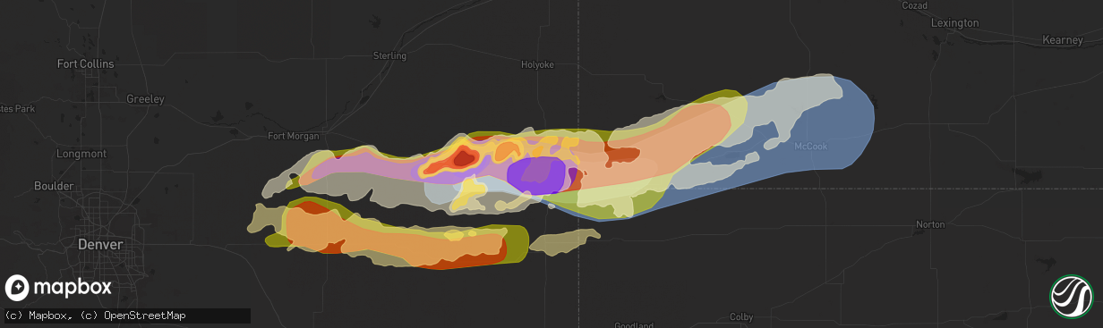
Hail
Wind
Tornado
2,700
Estimated number of impacted properties by a 1.00" hail or larger2,590
Estimated number of impacted properties by a 1.75" hail or larger4,721
Estimated number of impacted properties by a 2.50" hail or largerStorm reports in Wray, CO
Wray, CO
| Date | Description |
|---|---|
| 05/19/202411:45 PM CDT | Public report via social media of quarter hail 1/2 mile north of vernon... Co. |
| 05/19/202411:40 PM CDT | Report of estimated 70 mph wind gusts on hwy 385 approx. 3.5 to 1.5 miles south of hwy 34 in wray. |
| 05/19/202411:31 PM CDT | Weatherlink site osmus farm. |
| 05/19/202411:28 PM CDT | Public report and photos via social media of hail ranging from 1-1.25 inch diameter. |
| 05/19/202411:25 PM CDT | Report of a possible tornado near the co/ks/ne border viewed in lightning flashes an estimated 7-8 miles northwest from co rd z and co rd 5 in cheyenne county ks. |
| 05/19/202411:15 PM CDT | Awos station k2v5 2 nw wray. |
| 05/19/202411:15 PM CDT | Report and photo of approx. Ping pong ball size hail at the east end of wray... Co at 10:15 pm mdt. |
| 05/19/202411:15 PM CDT | A local report indicates 1.75 inch wind near Wray |
| 05/19/202411:15 PM CDT | Cocorahs report of golf ball size hail. Report of shredded leaves... Car dents... Damaged shingles... And broken house and car windows. Time estimated from radar. |
| 05/19/202411:11 PM CDT | Hailed for 30 minutes; lost power. |
| 05/19/202411:11 PM CDT | West windows gone... Sky lights broken. |
| 05/19/202411:10 PM CDT | Report and photos via social media of approx. Golf ball size hail in wray... Co. |
| 05/19/202411:04 PM CDT | Weatherlink site welp farms. |
All States Impacted by Hail Map on May 20, 2024
All Cities Impacted by Hail Map on May 20, 2024
- Mt Zion, IL
- Decatur, IL
- Marathon, FL
- Mineral Point, WI
- Waupun, WI
- Beaver Dam, WI
- Fox Lake, WI
- Oakfield, WI
- Marengo, IL
- Harvard, IL
- Burt, MI
- Montrose, MI
- Clio, MI
- Mount Morris, MI
- Saginaw, MI
- Frankenmuth, MI
- Millington, MI
- Rochelle, IL
- Steward, IL
- Otisville, MI
- Fostoria, MI
- Mayville, MI
- Bowling Green, OH
- Columbiaville, MI
- Otter Lake, MI
- Silverwood, MI
- Clifford, MI
- Marlette, MI
- Pemberville, OH
- Kingston, MI
- Port Clinton, OH
- Fremont, OH
- Brown City, MI
- Applegate, MI
- Croswell, MI
- Peck, MI
- Oak Harbor, OH
- Carsonville, MI
- Barrington, IL
- Saint Charles, IL
- South Elgin, IL
- Elgin, IL
- Bartlett, IL
- Wayne, IL
- Yale, MI
- Avoca, MI
- Armada, MI
- Wauconda, IL
- Lake Zurich, IL
- Streamwood, IL
- Hoffman Estates, IL
- Mundelein, IL
- Dundee, IL
- Palatine, IL
- Fox River Grove, IL
- Cary, IL
- Grayslake, IL
- Round Lake, IL
- Mchenry, IL
- Island Lake, IL
- Richmond, MI
- Carpentersville, IL
- Homer Glen, IL
- Lockport, IL
- New Haven, MI
- Orland Park, IL
- Palos Park, IL
- Goodells, MI
- Columbus, MI
- Memphis, MI
- Mayville, WI
- Burnett, WI
- Brandon, WI
- Vernon Hills, IL
- Libertyville, IL
- Washington, MI
- Potosi, MO
- Alsip, IL
- Chicago, IL
- Blue Island, IL
- Belgrade, MO
- Pompano Beach, FL
- Fort Lauderdale, FL
- Palos Heights, IL
- Crestwood, IL
- Cicero, IL
- Clinton Township, MI
- Sterling Heights, MI
- Fraser, MI
- Warren, MI
- Belleview, MO
- Bradley, IL
- Kankakee, IL
- Bourbonnais, IL
- Caledonia, MO
- Ironton, MO
- Beecher, IL
- Grant Park, IL
- Middle Brook, MO
- Pilot Knob, MO
- Cedar Lake, IN
- Lowell, IN
- Hebron, IN
- Crown Point, IN
- Valparaiso, IN
- Kouts, IN
- Thawville, IL
- Roberts, IL
- Lake Worth, FL
- Wellington, FL
- Onarga, IL
- Boynton Beach, FL
- Lake Village, IN
- Demotte, IN
- Thayer, IN
- Shelby, IN
- West Palm Beach, FL
- Gilman, IL
- Lindsey, OH
- Hayfield, MN
- Dodge Center, MN
- Phillips, NE
- Aurora, NE
- Sanborn, IA
- Primghar, IA
- Bradshaw, NE
- Waco, NE
- York, NE
- Stromsburg, NE
- Benedict, NE
- Wood River, NE
- Kasson, MN
- Marquette, NE
- Hartley, IA
- Polk, NE
- Byron, MN
- Schererville, IN
- Saint John, IN
- Central City, NE
- Chapman, NE
- Fort Morgan, CO
- Alda, NE
- Grand Island, NE
- Rising City, NE
- Wheatfield, IN
- Osceola, NE
- Shelton, NE
- Blooming Prairie, MN
- Remsen, IA
- Brush, CO
- Woodrow, CO
- Malcolm, NE
- Lincoln, NE
- Everly, IA
- Garland, NE
- Seward, NE
- Bellwood, NE
- Shelby, NE
- Clarks, NE
- Royal, IA
- Sutherland, IA
- Peterson, IA
- Spencer, IA
- Greenville, IA
- Sioux Rapids, IA
- Elm Creek, NE
- Akron, CO
- Milford, IA
- Pine Island, MN
- West Concord, MN
- Raymond, NE
- Mantorville, MN
- Clifton, IL
- Momence, IL
- Bee, NE
- Surprise, NE
- Watkins, CO
- Schneider, IN
- Hordville, NE
- Harrison, MI
- Lake, MI
- Farwell, MI
- Clare, MI
- Gladwin, MI
- Webb, IA
- Dickens, IA
- Marcus, IA
- Valparaiso, NE
- Dwight, NE
- Davey, NE
- Bennett, CO
- Chebanse, IL
- Sheldon, IA
- Silver Creek, NE
- Columbus, NE
- Creighton, NE
- Archer, IA
- Gillett Grove, IA
- Ruthven, IA
- Paullina, IA
- Granville, IA
- Cleghorn, IA
- Ashton, IA
- David City, NE
- Shelby, IA
- Byers, CO
- Strasburg, CO
- Fordyce, NE
- Crofton, NE
- Waltham, MN
- Wiggins, CO
- Roggen, CO
- Zumbrota, MN
- Orchard, NE
- Otis, CO
- Ayrshire, IA
- Winnetoon, NE
- Bloomfield, NE
- Harlan, IA
- Portsmouth, IA
- Verdigre, NE
- Colon, NE
- Brainard, NE
- Titonka, IA
- Aurora, CO
- Laurens, IA
- Curlew, IA
- Mazeppa, MN
- Melvin, IA
- Ames, NE
- Fremont, NE
- Cedar Bluffs, NE
- Deer Trail, CO
- Austin, MN
- Weston, NE
- Prague, NE
- Bruno, NE
- Larrabee, IA
- Meriden, IA
- Cherokee, IA
- Wesley, IA
- Oronoco, MN
- Alton, IA
- Leland, IA
- Forest City, IA
- Burns, WY
- Cheyenne, WY
- Blair, NE
- Worthington, MN
- Panama, IA
- Mallard, IA
- Havelock, IA
- Burt, IA
- Sibley, IA
- Brewster, MN
- Fulda, MN
- Hooper, NE
- Colorado Springs, CO
- Peyton, CO
- Elbert, CO
- Saint Anne, IL
- Linwood, NE
- Aurelia, IA
- Harrisburg, NE
- Vermillion, SD
- Herman, NE
- Malmo, NE
- Winslow, NE
- Center, NE
- Scarville, IA
- Martinton, IL
- Thompson, IA
- Lake Mills, IA
- Brownsdale, MN
- Yuma, CO
- Ulysses, NE
- Hartington, NE
- Pine Bluffs, WY
- Albin, WY
- Saint Helena, NE
- Wynot, NE
- Wahoo, NE
- Rolfe, IA
- Linn Grove, IA
- Alta, IA
- Earling, IA
- Heron Lake, MN
- Ceresco, NE
- Morse Bluff, NE
- Craig, NE
- Woden, IA
- Staplehurst, NE
- Tekamah, NE
- Newcastle, NE
- Westphalia, IA
- Lindon, CO
- Okabena, MN
- Uehling, NE
- Ashkum, IL
- Ravenna, NE
- Decatur, NE
- Volin, SD
- Eckley, CO
- Algona, IA
- Rembrandt, IA
- Onawa, IA
- Valley, NE
- Mead, NE
- Britt, IA
- Kirkman, IA
- Brewster, NE
- Rose Creek, MN
- Whiting, IA
- Maskell, NE
- Lakefield, MN
- Taylor, NE
- Albert Lea, MN
- Anton, CO
- Macy, NE
- Anselmo, NE
- Arnold, NE
- Marathon, IA
- Walthill, NE
- Winnebago, NE
- Dunning, NE
- Ponca, NE
- Elk Point, SD
- Homer, NE
- Rosalie, NE
- Oakland, NE
- Lyons, NE
- Salix, IA
- Sloan, IA
- Sergeant Bluff, IA
- Sioux City, IA
- Merna, NE
- Wray, CO
- Dakota City, NE
- South Sioux City, NE
- Bronson, IA
- Lawton, IA
- Hornick, IA
- Arlington, NE
- Bennington, NE
- Burwell, NE
- Pembroke Township, IL
- Donovan, IL
- Beaverville, IL
- Sleepy Eye, MN
- Swea City, IA
- Wallace, NE
- Dexter, MN
- Elkton, MN
- Broken Bow, NE
- Callaway, NE
- Ansley, NE
- Vernon, CO
- Cope, CO
- Bassett, NE
- Kennard, NE
- Dickens, NE
- Mapleton, IA
- Ithaca, NE
- Yutan, NE
- Lansing, MN
- Adams, MN
- New Ulm, MN
- Newell, IA
- Albert City, IA
- Ashland, NE
- Gibbon, MN
- Alpha, MN
- Anthon, IA
- Oto, IA
- Coleridge, NE
- Westfield, IA
- Moville, IA
- Westerville, NE
- Fort Calhoun, NE
- Omaha, NE
- Sherburn, MN
- Elkhorn, NE
- Menlo, IA
- Agate, CO
- Corwith, IA
- Waverly, NE
- Laurel, NE
- Danbury, IA
- Washington, NE
- Boys Town, NE
- Morgan, MN
- Jefferson, SD
- Casey, IA
- Comstock, NE
- Crescent, IA
- Missouri Valley, IA
- Kingsley, IA
- Hinton, IA
- Fairmont, MN
- Welcome, MN
- Saint Francis, KS
- Haigler, NE
- Holstein, IA
- Correctionville, IA
- Jackson, NE
- Merrill, IA
- Irwin, IA
- Manning, IA
- Manilla, IA
- Guthrie Center, IA
- Pierson, IA
- Ord, NE
- Gretna, NE
- Janesville, MN
- Pocahontas, IA
- Winnebago, MN
- Memphis, NE
- Honey Creek, IA
- Arcadia, NE
- Fairfax, MN
- Franklin, MN
- Whittemore, IA
- West Bend, IA
- Panora, IA
- Ceylon, MN
- Dixon, NE
- Ericson, NE
- Joes, CO
- Wellfleet, NE
- North Platte, NE
- Galva, IA
- Schaller, IA
- Templeton, IA
- Audubon, IA
- Akron, IA
- Le Mars, IA
- Waterloo, NE
- Kirk, CO
- Parks, NE
- Hector, MN
- Amboy, MN
- Coon Rapids, IA
- Dedham, IA
- Waseca, MN
- Bartlett, NE
- Niobrara, NE
- La Vista, NE
- Johnstown, NE
- Idalia, CO
- North Bend, NE
- Woodbine, IA
- Benkelman, NE
- Morristown, MN
- Waterville, MN
- Neola, IA
- Buffalo Lake, MN
- Maywood, NE
- Glidden, IA
- Carroll, IA
- Osage, IA
- Genoa, CO
- Bird City, KS
- Underwood, IA
- Maxwell, NE
- Persia, IA
- Logan, IA
- Faribault, MN
- Kilkenny, MN
- Nickerson, NE
- Winterset, IA
- Max, NE
- Wauneta, NE
- Cairo, NE
- Brady, NE
- Saint Charles, IA
- Prole, IA
- Norwalk, IA
- Ackley, IA
- Minden, IA
- Avoca, IA
- Dannebrog, NE
- Saint Paul, NE
- Enders, NE
- Stratton, NE
- Bevington, IA
- Patterson, IA
- Wellsburg, IA
- Van Meter, IA
- Indianola, IA
- Palisade, NE
- Saint Libory, NE
- Cumming, IA
- Belmond, IA
- Clarion, IA
- Doniphan, NE
- Oakland, IA
- Hancock, IA
- Iowa Falls, IA
- Des Moines, IA
- Alden, IA
- New Providence, IA
- Eldora, IA
- Gothenburg, NE
- Steamboat Rock, IA
- Aplington, IA
- Kanawha, IA
- Forest Lake, MN
- Circle Pines, MN
- Hayes Center, NE
- Carlisle, IA
- Trenton, NE
- Culbertson, NE
- Hugo, MN
- Mitchellville, IA
- McDonald, KS
- Cedar Falls, IA
- Scandia, MN
- Wyoming, MN
- Chisago City, MN
- Kimballton, IA
- Elk Horn, IA
- Runnells, IA
- Scribner, NE
- Greenwood, NE
- Eustis, NE
- McCook, NE
- Farnam, NE
- Stacy, MN
- Lindstrom, MN
- Center City, MN
- Brownsville, WI
- Schuyler, NE
- Walnut, IA
- New Hartford, IA
- Atwood, KS
- Exira, IA
- Hamlin, IA
- Defiance, IA
- Gray, IA
- Taylors Falls, MN
- Saint Croix Falls, WI
- Shafer, MN
- North Branch, MN
- Hampton, IA
- Sheffield, IA
- Curtis, NE
- Cozad, NE
- Hampton, NE
- Cushing, WI
- Luck, WI
- Lebanon, NE
- Bartley, NE
- Wilsonville, NE
- Indianola, NE
- Cambridge, NE
- Stockville, NE
- Moorefield, NE
- Adair, IA
- Montour, IA
- Toledo, IA
- Garwin, IA
- Tama, IA
- Giltner, NE
- Danbury, NE
- Abie, NE
- Frederic, WI
- Mingo, IA
- Morton, MN
- Overton, NE
- Elwood, NE
- Hendley, NE
- Norton, KS
- Holbrook, NE
- Beaver City, NE
- Gresham, NE
- Conrad, IA
- Beaman, IA
- Grundy Center, IA
- Liscomb, IA
- Reinbeck, IA
- Gladbrook, IA
- Holland, IA
- Morrison, IA
- Dike, IA
- Waterloo, IA
- Parkersburg, IA
- Hudson, IA
- Janesville, IA
- Stout, IA
- Dunkerton, IA
- Dewar, IA
- Evansdale, IA
- Denver, IA
- Waverly, IA
- Readlyn, IA
- Smithfield, NE
- Bertrand, NE
- New Hampton, IA
- Fairbank, IA
- Tripoli, IA
- Sumner, IA
- Oxford, NE
- Dow City, IA
- Stamford, NE
- Orleans, NE
- Dunlap, IA
- Alma, NE
- Republican City, NE
- Little Cedar, IA
- Hertel, WI
- Shell Lake, WI
- Webster, WI
- Spooner, WI
- Pemberton, MN
- Alta Vista, IA
- Utica, NE
- Stewartville, MN
- Jackson, MN
- Modale, IA
- Mondamin, IA
- Wolbach, NE
- Cedar Rapids, NE
- Newton, IA
- Kellogg, IA
- Plainview, NE
- Storm Lake, IA
- George, IA
- Smithland, IA
- Wausa, NE
- Fonda, IA
- Belgrade, NE
- Palmer, NE
- Redwood Falls, MN
- Cushing, IA
- Colfax, IA
- Greeley, NE
- Spalding, NE
- Scotia, NE
- Elba, NE
- Fullerton, NE
- Archer, NE
- Albion, NE
- Primrose, NE
- Saint Edward, NE
- Genoa, NE
- Monroe, NE
- Gilman, IA
- Grinnell, IA
- Mount Horeb, WI
- Platte Center, NE
- Lindsay, NE
- Duncan, NE
- Geneva, NE
- Fairmont, NE
- McCool Junction, NE
- Henderson, NE
- Exeter, NE
- Milligan, NE
- Beaver Crossing, NE
- Humphrey, NE
- Creston, NE
- Clarkson, NE
- Leigh, NE
- Friend, NE
- Cordova, NE
- Goehner, NE
- Swan, IA
- Otley, IA
- Monroe, IA
- Dodge, NE
- Howells, NE
- Rogers, NE
- Prairie City, IA
- Marshalltown, IA
- Reasnor, IA
- Snyder, NE
- West Point, NE
- Sully, IA
- Killduff, IA
- Pella, IA
- Lynnville, IA
- Bennet, NE
- Carter Lake, IA
- Walton, NE
- Council Bluffs, IA
- Sterling, NE
- Burr, NE
- Searsboro, IA
- Malcom, IA
- Palmyra, NE
- Montezuma, IA
- Treynor, IA
- McClelland, IA
- Papillion, NE
- Douglas, NE
- Pisgah, IA
- Little Sioux, IA
- Bellevue, NE
- Magnolia, IA
- Madison, NE
- Stanton, NE
- Pilger, NE
- Wisner, NE
- Beemer, NE
- Waterbury, NE
- Emerson, NE
- Wakefield, NE
- Hubbard, NE
- Bancroft, NE
- Thurston, NE
- Pender, NE
- Wayne, NE
- North Sioux City, SD
- Blencoe, IA
- Castana, IA
- Moorhead, IA
- Rodney, IA
- Climbing Hill, IA
- Soldier, IA
- Cook, NE
- Carson, IA
- Springfield, NE
- Tecumseh, NE
- New Sharon, IA
- Syracuse, NE
- Otoe, NE
- Unadilla, NE
- Chelsea, IA
- Brooklyn, IA
- Avoca, NE
- Elmwood, NE
- Plattsmouth, NE
- Louisville, NE
- Belle Plaine, IA
- Johnson, NE
- Brock, NE
- Auburn, NE
- Glenwood, IA
- Pacific Junction, IA
- Offutt Afb, NE
- Hartwick, IA
- Elberon, IA
- Talmage, NE
- Silver City, IA
- Ute, IA
- Macedonia, IA
- Griswold, IA
- Charter Oak, IA
- Battle Creek, IA
- Ricketts, IA
- Arion, IA
- Denison, IA
- Lewis, IA
- Henderson, IA
- Red Oak, IA
- Malvern, IA
- Mineola, IA
- Emerson, IA
- Hastings, IA
- Imogene, IA
- Marengo, IA
- Keystone, IA
- Luzerne, IA
- Victor, IA
- Brownville, NE
- Peru, NE
- Nemaha, NE
- Blairstown, IA
- Julian, NE
- Humboldt, NE


