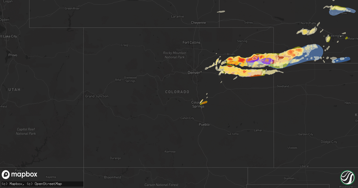
Hail Map in Colorado on May 20, 2024
Get this storm
May 20 map
$229
one time, instant access
Download today. No call, no setup
Keep the $229
Bought the map and want the full workflow? Apply the entire $229 to a subscription within 7 days. None of it is wasted.
Every map, not just this one
This buys you this map. Subscription and you get every map we run, in the markets you choose from a few cities to whole states to nationwide. Plus real-time alerts the moment a storm fires.
Contact data
Name, contact info, occupancy, even credit band for addresses in the footprint. You go from where it hit to who to call.
Become the source they trust
Unlimited branding weather history reports on demand. You already have the documented answer ready for the property owner, and you are the one who showed up with it.
Property data and RoofTrace estimates
Pull up any address you have got, its value and the exact code rules for that jurisdiction, straight from One Click Code. Then RoofTrace estimates the squares, pitch, and roof value, priced the way you price.
Storm reports in Colorado
Colorado
| Date | Description |
|---|---|
| 05/20/20246:53 PM CDT | Asos station kdro durango la plata cnty airport. Gust from nearby virga showers. |
| 05/19/202411:45 PM CDT | Public report via social media of quarter hail 1/2 mile north of vernon... Co. |
| 05/19/202411:40 PM CDT | Report of estimated 70 mph wind gusts on hwy 385 approx. 3.5 to 1.5 miles south of hwy 34 in wray. |
| 05/19/202411:34 PM CDT | Report and photos via social media |
| 05/19/202411:31 PM CDT | Weatherlink site osmus farm. |
| 05/19/202411:28 PM CDT | Public report and photos via social media of hail ranging from 1-1.25 inch diameter. |
| 05/19/202411:25 PM CDT | Report of a possible tornado near the co/ks/ne border viewed in lightning flashes an estimated 7-8 miles northwest from co rd z and co rd 5 in cheyenne county ks. |
| 05/19/202411:15 PM CDT | Awos station k2v5 2 nw wray. |
| 05/19/202411:15 PM CDT | Cocorahs report of golf ball size hail. Report of shredded leaves... Car dents... Damaged shingles... And broken house and car windows. Time estimated from radar. |
| 05/19/202411:15 PM CDT | A local report indicates 1.75 inch wind near Wray |
| 05/19/202411:15 PM CDT | Report and photo of approx. Ping pong ball size hail at the east end of wray... Co at 10:15 pm mdt. |
| 05/19/202411:11 PM CDT | West windows gone... Sky lights broken. |
| 05/19/202411:11 PM CDT | Hailed for 30 minutes; lost power. |
| 05/19/202411:10 PM CDT | Report and photos via social media of approx. Golf ball size hail in wray... Co. |
| 05/19/202411:04 PM CDT | Weatherlink site welp farms. |
| 05/19/202411:02 PM CDT | Report from mping: baseball |
| 05/19/202410:50 PM CDT | Occurred with nickel size hail. |
| 05/19/202410:43 PM CDT | Report from mping: tennis ball |
| 05/19/202410:43 PM CDT | A local report indicates 1.75 inch wind near 3 ENE Lindon |
| 05/19/202410:36 PM CDT | Several power poles snapped near the intersection of cr 33 and hwy 59. |
| 05/19/202410:36 PM CDT | Report from mping: quarter |
| 05/19/202410:33 PM CDT | A local report indicates 2.00 inch wind near 6 NE Lindon |
| 05/19/202410:33 PM CDT | Report from mping: ping pong ball |
| 05/19/202410:32 PM CDT | Report from mping: quarter |
| 05/19/202410:20 PM CDT | Corrects previous hail report from 5 ne yuma. Report and photos via social media |
| 05/19/202410:16 PM CDT | Weatherunderground site kcoyuma29. |
| 05/19/202410:15 PM CDT | Mesonet station yum02 2 n yuma 2. |
| 05/19/202410:14 PM CDT | Quarter to golf ball sized hail. |
| 05/19/202410:14 PM CDT | Corrects previous tstm wnd gst report from 2 sse yuma. The awos in yuma |
| 05/19/202410:12 PM CDT | Awos station k2v6 1 se yuma. |
| 05/19/202410:10 PM CDT | 2 inch hail reported on the southwest side of yuma... Started around 9:10 pm mdt and lasted approx. 15 minutes. Location estimated. |
| 05/19/202410:10 PM CDT | Report and photos via social media of hail up to golf ball size but mostly smaller stones with drifts estimated from photos to be up to around 1 foot tall. Wind driven |
| 05/19/202410:00 PM CDT | Emergency manager reports fire department had tennis to softball size hail about 1 mile south of yuma. |
| 05/19/202410:00 PM CDT | Trained spotter reported that hen egg |
| 05/19/202410:00 PM CDT | Report and photos via social media |
| 05/19/20249:26 PM CDT | Hail |
| 05/19/20249:26 PM CDT | Hailed for 10 minutes. |
| 05/19/20249:25 PM CDT | Report from mping: hen egg |
| 05/19/20249:25 PM CDT | Report from ambient weather network sensor. |
| 05/19/20249:25 PM CDT | A local report indicates 1.75 inch wind near 3 SSE Hoyt Beet Dump |
| 05/19/20249:10 PM CDT | Report from mping: hen egg+ |
| 05/19/20249:09 PM CDT | A local report indicates 1.00 inch wind near 2 WSW Peterson AFB |
| 05/19/20249:07 PM CDT | A local report indicates 1.50 inch wind near 3 SSE Falcon |
| 05/19/20249:05 PM CDT | A local report indicates 2.00 inch wind near Otis |
| 05/19/20248:52 PM CDT | Report from mping: golf ball |
| 05/19/20248:38 PM CDT | Report from mping: quarter |
| 05/19/20248:35 PM CDT | Report from mping: golf ball |
| 05/19/20248:35 PM CDT | 3 inches of rain measured with this storm. The hail did extensive damage to the property. |
| 05/19/20248:30 PM CDT | 1.5 inches of rain in 20 minutes. |
| 05/19/20248:28 PM CDT | Report from mping: quarter |
| 05/19/20248:25 PM CDT | Photo with a caliper measurement of a large hailstone measured approximately 30 minutes after hail fell. Time and location estimated. |
| 05/19/20248:22 PM CDT | 2.1 inch diameter hail measured by digital caliper. Time estimated. |
| 05/19/20247:45 PM CDT | Corrects previous hail report from 2 nnw gary. Destroyed windshield. |
| 05/19/20247:32 PM CDT | A local report indicates 1.50 inch wind near 5 N Gary |
All States Impacted by Hail Map on May 20, 2024
Cities Impacted by Hail Map on May 20, 2024
- Mt Zion, IL
- Decatur, IL
- Marathon, FL
- Mineral Point, WI
- Waupun, WI
- Beaver Dam, WI
- Fox Lake, WI
- Oakfield, WI
- Marengo, IL
- Harvard, IL
- Burt, MI
- Montrose, MI
- Clio, MI
- Mount Morris, MI
- Saginaw, MI
- Frankenmuth, MI
- Millington, MI
- Rochelle, IL
- Steward, IL
- Otisville, MI
- Fostoria, MI
- Mayville, MI
- Bowling Green, OH
- Columbiaville, MI
- Otter Lake, MI
- Silverwood, MI
- Clifford, MI
- Marlette, MI
- Pemberville, OH
- Kingston, MI
- Port Clinton, OH
- Fremont, OH
- Brown City, MI
- Applegate, MI
- Croswell, MI
- Peck, MI
- Oak Harbor, OH
- Carsonville, MI
- Barrington, IL
- Saint Charles, IL
- South Elgin, IL
- Elgin, IL
- Bartlett, IL
- Wayne, IL
- Yale, MI
- Avoca, MI
- Armada, MI
- Wauconda, IL
- Lake Zurich, IL
- Streamwood, IL
- Hoffman Estates, IL
- Mundelein, IL
- Dundee, IL
- Palatine, IL
- Fox River Grove, IL
- Cary, IL
- Grayslake, IL
- Round Lake, IL
- Mchenry, IL
- Island Lake, IL
- Richmond, MI
- Carpentersville, IL
- Homer Glen, IL
- Lockport, IL
- New Haven, MI
- Orland Park, IL
- Palos Park, IL
- Goodells, MI
- Columbus, MI
- Memphis, MI
- Mayville, WI
- Burnett, WI
- Brandon, WI
- Vernon Hills, IL
- Libertyville, IL
- Washington, MI
- Potosi, MO
- Alsip, IL
- Chicago, IL
- Blue Island, IL
- Belgrade, MO
- Pompano Beach, FL
- Fort Lauderdale, FL
- Palos Heights, IL
- Crestwood, IL
- Cicero, IL
- Clinton Township, MI
- Sterling Heights, MI
- Fraser, MI
- Warren, MI
- Belleview, MO
- Bradley, IL
- Kankakee, IL
- Bourbonnais, IL
- Caledonia, MO
- Ironton, MO
- Beecher, IL
- Grant Park, IL
- Middle Brook, MO
- Pilot Knob, MO
- Cedar Lake, IN
- Lowell, IN
- Hebron, IN
- Crown Point, IN
- Valparaiso, IN
- Kouts, IN
- Thawville, IL
- Roberts, IL
- Lake Worth, FL
- Wellington, FL
- Onarga, IL
- Boynton Beach, FL
- Lake Village, IN
- Demotte, IN
- Thayer, IN
- Shelby, IN
- West Palm Beach, FL
- Gilman, IL
- Lindsey, OH
- Hayfield, MN
- Dodge Center, MN
- Phillips, NE
- Aurora, NE
- Sanborn, IA
- Primghar, IA
- Bradshaw, NE
- Waco, NE
- York, NE
- Stromsburg, NE
- Benedict, NE
- Wood River, NE
- Kasson, MN
- Marquette, NE
- Hartley, IA
- Polk, NE
- Byron, MN
- Schererville, IN
- Saint John, IN
- Central City, NE
- Chapman, NE
- Fort Morgan, CO
- Alda, NE
- Grand Island, NE
- Rising City, NE
- Wheatfield, IN
- Osceola, NE
- Shelton, NE
- Blooming Prairie, MN
- Remsen, IA
- Brush, CO
- Woodrow, CO
- Malcolm, NE
- Lincoln, NE
- Everly, IA
- Garland, NE
- Seward, NE
- Bellwood, NE
- Shelby, NE
- Clarks, NE
- Royal, IA
- Sutherland, IA
- Peterson, IA
- Spencer, IA
- Greenville, IA
- Sioux Rapids, IA
- Elm Creek, NE
- Akron, CO
- Milford, IA
- Pine Island, MN
- West Concord, MN
- Raymond, NE
- Mantorville, MN
- Clifton, IL
- Momence, IL
- Bee, NE
- Surprise, NE
- Watkins, CO
- Schneider, IN
- Hordville, NE
- Harrison, MI
- Lake, MI
- Farwell, MI
- Clare, MI
- Gladwin, MI
- Webb, IA
- Dickens, IA
- Marcus, IA
- Valparaiso, NE
- Dwight, NE
- Davey, NE
- Bennett, CO
- Chebanse, IL
- Sheldon, IA
- Silver Creek, NE
- Columbus, NE
- Creighton, NE
- Archer, IA
- Gillett Grove, IA
- Ruthven, IA
- Paullina, IA
- Granville, IA
- Cleghorn, IA
- Ashton, IA
- David City, NE
- Shelby, IA
- Byers, CO
- Strasburg, CO
- Fordyce, NE
- Crofton, NE
- Waltham, MN
- Wiggins, CO
- Roggen, CO
- Zumbrota, MN
- Orchard, NE
- Otis, CO
- Ayrshire, IA
- Winnetoon, NE
- Bloomfield, NE
- Harlan, IA
- Portsmouth, IA
- Verdigre, NE
- Colon, NE
- Brainard, NE
- Titonka, IA
- Aurora, CO
- Laurens, IA
- Curlew, IA
- Mazeppa, MN
- Melvin, IA
- Ames, NE
- Fremont, NE
- Cedar Bluffs, NE
- Deer Trail, CO
- Austin, MN
- Weston, NE
- Prague, NE
- Bruno, NE
- Larrabee, IA
- Meriden, IA
- Cherokee, IA
- Wesley, IA
- Oronoco, MN
- Alton, IA
- Leland, IA
- Forest City, IA
- Burns, WY
- Cheyenne, WY
- Blair, NE
- Worthington, MN
- Panama, IA
- Mallard, IA
- Havelock, IA
- Burt, IA
- Sibley, IA
- Brewster, MN
- Fulda, MN
- Hooper, NE
- Colorado Springs, CO
- Peyton, CO
- Elbert, CO
- Saint Anne, IL
- Linwood, NE
- Aurelia, IA
- Harrisburg, NE
- Vermillion, SD
- Herman, NE
- Malmo, NE
- Winslow, NE
- Center, NE
- Scarville, IA
- Martinton, IL
- Thompson, IA
- Lake Mills, IA
- Brownsdale, MN
- Yuma, CO
- Ulysses, NE
- Hartington, NE
- Pine Bluffs, WY
- Albin, WY
- Saint Helena, NE
- Wynot, NE
- Wahoo, NE
- Rolfe, IA
- Linn Grove, IA
- Alta, IA
- Earling, IA
- Heron Lake, MN
- Ceresco, NE
- Morse Bluff, NE
- Craig, NE
- Woden, IA
- Staplehurst, NE
- Tekamah, NE
- Newcastle, NE
- Westphalia, IA
- Lindon, CO
- Okabena, MN
- Uehling, NE
- Ashkum, IL
- Ravenna, NE
- Decatur, NE
- Volin, SD
- Eckley, CO
- Algona, IA
- Rembrandt, IA
- Onawa, IA
- Valley, NE
- Mead, NE
- Britt, IA
- Kirkman, IA
- Brewster, NE
- Rose Creek, MN
- Whiting, IA
- Maskell, NE
- Lakefield, MN
- Taylor, NE
- Albert Lea, MN
- Anton, CO
- Macy, NE
- Anselmo, NE
- Arnold, NE
- Marathon, IA
- Walthill, NE
- Winnebago, NE
- Dunning, NE
- Ponca, NE
- Elk Point, SD
- Homer, NE
- Rosalie, NE
- Oakland, NE
- Lyons, NE
- Salix, IA
- Sloan, IA
- Sergeant Bluff, IA
- Sioux City, IA
- Merna, NE
- Wray, CO
- Dakota City, NE
- South Sioux City, NE
- Bronson, IA
- Lawton, IA
- Hornick, IA
- Arlington, NE
- Bennington, NE
- Burwell, NE
- Pembroke Township, IL
- Donovan, IL
- Beaverville, IL
- Sleepy Eye, MN
- Swea City, IA
- Wallace, NE
- Dexter, MN
- Elkton, MN
- Broken Bow, NE
- Callaway, NE
- Ansley, NE
- Vernon, CO
- Cope, CO
- Bassett, NE
- Kennard, NE
- Dickens, NE
- Mapleton, IA
- Ithaca, NE
- Yutan, NE
- Lansing, MN
- Adams, MN
- New Ulm, MN
- Newell, IA
- Albert City, IA
- Ashland, NE
- Gibbon, MN
- Alpha, MN
- Anthon, IA
- Oto, IA
- Coleridge, NE
- Westfield, IA
- Moville, IA
- Westerville, NE
- Fort Calhoun, NE
- Omaha, NE
- Sherburn, MN
- Elkhorn, NE
- Menlo, IA
- Agate, CO
- Corwith, IA
- Waverly, NE
- Laurel, NE
- Danbury, IA
- Washington, NE
- Boys Town, NE
- Morgan, MN
- Jefferson, SD
- Casey, IA
- Comstock, NE
- Crescent, IA
- Missouri Valley, IA
- Kingsley, IA
- Hinton, IA
- Fairmont, MN
- Welcome, MN
- Saint Francis, KS
- Haigler, NE
- Holstein, IA
- Correctionville, IA
- Jackson, NE
- Merrill, IA
- Irwin, IA
- Manning, IA
- Manilla, IA
- Guthrie Center, IA
- Pierson, IA
- Ord, NE
- Gretna, NE
- Janesville, MN
- Pocahontas, IA
- Winnebago, MN
- Memphis, NE
- Honey Creek, IA
- Arcadia, NE
- Fairfax, MN
- Franklin, MN
- Whittemore, IA
- West Bend, IA
- Panora, IA
- Ceylon, MN
- Dixon, NE
- Ericson, NE
- Joes, CO
- Wellfleet, NE
- North Platte, NE
- Galva, IA
- Schaller, IA
- Templeton, IA
- Audubon, IA
- Akron, IA
- Le Mars, IA
- Waterloo, NE
- Kirk, CO
- Parks, NE
- Hector, MN
- Amboy, MN
- Coon Rapids, IA
- Dedham, IA
- Waseca, MN
- Bartlett, NE
- Niobrara, NE
- La Vista, NE
- Johnstown, NE
- Idalia, CO
- North Bend, NE
- Woodbine, IA
- Benkelman, NE
- Morristown, MN
- Waterville, MN
- Neola, IA
- Buffalo Lake, MN
- Maywood, NE
- Glidden, IA
- Carroll, IA
- Osage, IA
- Genoa, CO
- Bird City, KS
- Underwood, IA
- Maxwell, NE
- Persia, IA
- Logan, IA
- Faribault, MN
- Kilkenny, MN
- Nickerson, NE
- Winterset, IA
- Max, NE
- Wauneta, NE
- Cairo, NE
- Brady, NE
- Saint Charles, IA
- Prole, IA
- Norwalk, IA
- Ackley, IA
- Minden, IA
- Avoca, IA
- Dannebrog, NE
- Saint Paul, NE
- Enders, NE
- Stratton, NE
- Bevington, IA
- Patterson, IA
- Wellsburg, IA
- Van Meter, IA
- Indianola, IA
- Palisade, NE
- Saint Libory, NE
- Cumming, IA
- Belmond, IA
- Clarion, IA
- Doniphan, NE
- Oakland, IA
- Hancock, IA
- Iowa Falls, IA
- Des Moines, IA
- Alden, IA
- New Providence, IA
- Eldora, IA
- Gothenburg, NE
- Steamboat Rock, IA
- Aplington, IA
- Kanawha, IA
- Forest Lake, MN
- Circle Pines, MN
- Hayes Center, NE
- Carlisle, IA
- Trenton, NE
- Culbertson, NE
- Hugo, MN
- Mitchellville, IA
- McDonald, KS
- Cedar Falls, IA
- Scandia, MN
- Wyoming, MN
- Chisago City, MN
- Kimballton, IA
- Elk Horn, IA
- Runnells, IA
- Scribner, NE
- Greenwood, NE
- Eustis, NE
- McCook, NE
- Farnam, NE
- Stacy, MN
- Lindstrom, MN
- Center City, MN
- Brownsville, WI
- Schuyler, NE
- Walnut, IA
- New Hartford, IA
- Atwood, KS
- Exira, IA
- Hamlin, IA
- Defiance, IA
- Gray, IA
- Taylors Falls, MN
- Saint Croix Falls, WI
- Shafer, MN
- North Branch, MN
- Hampton, IA
- Sheffield, IA
- Curtis, NE
- Cozad, NE
- Hampton, NE
- Cushing, WI
- Luck, WI
- Lebanon, NE
- Bartley, NE
- Wilsonville, NE
- Indianola, NE
- Cambridge, NE
- Stockville, NE
- Moorefield, NE
- Adair, IA
- Montour, IA
- Toledo, IA
- Garwin, IA
- Tama, IA
- Giltner, NE
- Danbury, NE
- Abie, NE
- Frederic, WI
- Mingo, IA
- Morton, MN
- Overton, NE
- Elwood, NE
- Hendley, NE
- Norton, KS
- Holbrook, NE
- Beaver City, NE
- Gresham, NE
- Conrad, IA
- Beaman, IA
- Grundy Center, IA
- Liscomb, IA
- Reinbeck, IA
- Gladbrook, IA
- Holland, IA
- Morrison, IA
- Dike, IA
- Waterloo, IA
- Parkersburg, IA
- Hudson, IA
- Janesville, IA
- Stout, IA
- Dunkerton, IA
- Dewar, IA
- Evansdale, IA
- Denver, IA
- Waverly, IA
- Readlyn, IA
- Smithfield, NE
- Bertrand, NE
- New Hampton, IA
- Fairbank, IA
- Tripoli, IA
- Sumner, IA
- Oxford, NE
- Dow City, IA
- Stamford, NE
- Orleans, NE
- Dunlap, IA
- Alma, NE
- Republican City, NE
- Little Cedar, IA
- Hertel, WI
- Shell Lake, WI
- Webster, WI
- Spooner, WI
- Pemberton, MN
- Alta Vista, IA
- Utica, NE
- Stewartville, MN
- Jackson, MN
- Modale, IA
- Mondamin, IA
- Wolbach, NE
- Cedar Rapids, NE
- Newton, IA
- Kellogg, IA
- Plainview, NE
- Storm Lake, IA
- George, IA
- Smithland, IA
- Wausa, NE
- Fonda, IA
- Belgrade, NE
- Palmer, NE
- Redwood Falls, MN
- Cushing, IA
- Colfax, IA
- Greeley, NE
- Spalding, NE
- Scotia, NE
- Elba, NE
- Fullerton, NE
- Archer, NE
- Albion, NE
- Primrose, NE
- Saint Edward, NE
- Genoa, NE
- Monroe, NE
- Gilman, IA
- Grinnell, IA
- Mount Horeb, WI
- Platte Center, NE
- Lindsay, NE
- Duncan, NE
- Geneva, NE
- Fairmont, NE
- McCool Junction, NE
- Henderson, NE
- Exeter, NE
- Milligan, NE
- Beaver Crossing, NE
- Humphrey, NE
- Creston, NE
- Clarkson, NE
- Leigh, NE
- Friend, NE
- Cordova, NE
- Goehner, NE
- Swan, IA
- Otley, IA
- Monroe, IA
- Dodge, NE
- Howells, NE
- Rogers, NE
- Prairie City, IA
- Marshalltown, IA
- Reasnor, IA
- Snyder, NE
- West Point, NE
- Sully, IA
- Killduff, IA
- Pella, IA
- Lynnville, IA
- Bennet, NE
- Carter Lake, IA
- Walton, NE
- Council Bluffs, IA
- Sterling, NE
- Burr, NE
- Searsboro, IA
- Malcom, IA
- Palmyra, NE
- Montezuma, IA
- Treynor, IA
- McClelland, IA
- Papillion, NE
- Douglas, NE
- Pisgah, IA
- Little Sioux, IA
- Bellevue, NE
- Magnolia, IA
- Madison, NE
- Stanton, NE
- Pilger, NE
- Wisner, NE
- Beemer, NE
- Waterbury, NE
- Emerson, NE
- Wakefield, NE
- Hubbard, NE
- Bancroft, NE
- Thurston, NE
- Pender, NE
- Wayne, NE
- North Sioux City, SD
- Blencoe, IA
- Castana, IA
- Moorhead, IA
- Rodney, IA
- Climbing Hill, IA
- Soldier, IA
- Cook, NE
- Carson, IA
- Springfield, NE
- Tecumseh, NE
- New Sharon, IA
- Syracuse, NE
- Otoe, NE
- Unadilla, NE
- Chelsea, IA
- Brooklyn, IA
- Avoca, NE
- Elmwood, NE
- Plattsmouth, NE
- Louisville, NE
- Belle Plaine, IA
- Johnson, NE
- Brock, NE
- Auburn, NE
- Glenwood, IA
- Pacific Junction, IA
- Offutt Afb, NE
- Hartwick, IA
- Elberon, IA
- Talmage, NE
- Silver City, IA
- Ute, IA
- Macedonia, IA
- Griswold, IA
- Charter Oak, IA
- Battle Creek, IA
- Ricketts, IA
- Arion, IA
- Denison, IA
- Lewis, IA
- Henderson, IA
- Red Oak, IA
- Malvern, IA
- Mineola, IA
- Emerson, IA
- Hastings, IA
- Imogene, IA
- Marengo, IA
- Keystone, IA
- Luzerne, IA
- Victor, IA
- Brownville, NE
- Peru, NE
- Nemaha, NE
- Blairstown, IA
- Julian, NE
- Humboldt, NE


