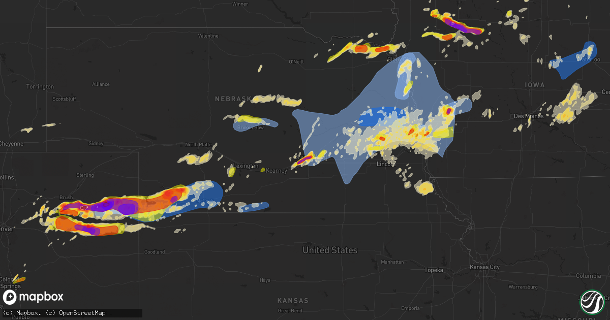
Hail Map on May 20, 2024
Get this storm
May 20 map
$229
one time, instant access
Download today. No call, no setup
Keep the $229
Bought the map and want the full workflow? Apply the entire $229 to a subscription within 7 days. None of it is wasted.
Every map, not just this one
This buys you this map. Subscription and you get every map we run, in the markets you choose from a few cities to whole states to nationwide. Plus real-time alerts the moment a storm fires.
Contact data
Name, contact info, occupancy, even credit band for addresses in the footprint. You go from where it hit to who to call.
Become the source they trust
Unlimited branding weather history reports on demand. You already have the documented answer ready for the property owner, and you are the one who showed up with it.
Property data and RoofTrace estimates
Pull up any address you have got, its value and the exact code rules for that jurisdiction, straight from One Click Code. Then RoofTrace estimates the squares, pitch, and roof value, priced the way you price.
States Impacted by Hail Map on May 20, 2024
Storm reports
Michigan
| Date | Description |
|---|---|
| 05/20/20246:10 PM CDT | Over 20 calls of trees and wires down in and around morley... Mi including damage to a transformer. |
| 05/20/20246:05 PM CDT | Trees and power lines down across the road. |
| 05/20/20246:04 PM CDT | Trees and wires down on the road on brady lake blvd. |
| 05/20/20245:18 PM CDT | Trees and power lines down north of fremont. |
| 05/20/20244:42 PM CDT | Photo sent via email of 1 inch hailstone. |
| 05/20/20243:10 PM CDT | Photo sent of tree down on chalmers and van dyke roads. |
| 05/20/20242:14 PM CDT | A local report indicates 1.50 inch wind near 1 NE Armada |
| 05/20/20241:25 PM CDT | Sporadic tree limbs and trees downed in sanilac county: including marlette... Deckerville... Sandusky... And cass city. |
| 05/20/202412:35 PM CDT | Trees reported down across the county... With the vassar area particulary the hardest hit. |
| 05/20/202411:40 AM CDT | 2-4 inch tree limbs downed... Along with a pine tree uprooted. |
| 05/19/20248:20 PM CDT | Delayed report: large tree uprooted at the corner of jackson and bliss roads. Time estimated from radar. |
| 05/19/20248:18 PM CDT | 60 mph thunderstorm wind gust measured at official nws observation at jackson airport. |
| 05/19/20247:21 PM CDT | Adams road closed north of m-18 due to downed power lines from thunderstorm winds. Time estimated by radar. |
| 05/19/20247:07 PM CDT | Time estimated based on radar. |
Ohio
| Date | Description |
|---|---|
| 05/20/20241:45 PM CDT | Utility pole and lines down. |
| 05/20/20241:36 PM CDT | Utility pole and lines down. Time estimated for radar. |
| 05/20/20241:31 PM CDT | Corrects previous tstm wnd dmg report from 4 n fremont. Utility pole and lines down. Time estimated via radar. |
| 05/20/20241:31 PM CDT | Damage sustained to the sheet metal roof and door of a barn on us-6. |
| 05/20/20241:26 PM CDT | Corrects previous tstm wnd dmg report from 3 nne stony prairie. Utility pole and lines down. Time estimated via radar. |
Nebraska
| Date | Description |
|---|---|
| 05/20/20246:24 AM CDT | A local report indicates 1.00 inch wind near 1 WSW Omaha |
| 05/20/20246:19 AM CDT | A local report indicates 60 MPH wind near 1 WSW Omaha |
| 05/20/20246:07 AM CDT | A local report indicates 62 MPH wind near 3 ESE Tekamah |
| 05/20/20246:02 AM CDT | A local report indicates 1.00 inch wind near 2 W Omaha |
| 05/20/20246:00 AM CDT | A local report indicates 1.50 inch wind near 1 W Omaha |
| 05/20/20245:51 AM CDT | Delayed report: roof taken off shed. Several large trees blown over. Time estimated from radar. |
| 05/20/20245:45 AM CDT | Numerous large trees down across valley view estates and valley view golf course. Delayed report. |
| 05/20/20245:42 AM CDT | A local report indicates 1.25 inch wind near 3 SSW Bennington |
| 05/20/20245:40 AM CDT | A local report indicates 1.00 inch wind near 2 SE Elkhorn |
| 05/20/20245:39 AM CDT | Numerous outbuildings damaged. Trees uprooted and powerlines down. Time based on radar. |
| 05/20/20245:37 AM CDT | A local report indicates 1.50 inch wind near Bennington |
| 05/20/20245:36 AM CDT | A local report indicates 1.00 inch wind near 3 WNW Boys Town |
| 05/20/20245:36 AM CDT | Report from mping of quarter sized hail southeast of bennington. |
| 05/20/20245:33 AM CDT | Report from mping of quarter sized hail south of bennington. |
| 05/20/20245:33 AM CDT | Corrects previous tstm wnd dmg report to fix the time delayed report: roof taken off shed. Several large trees blown over. Time estimated from radar. |
| 05/20/20245:33 AM CDT | 6 power poles down. Time based on radar. |
| 05/20/20245:33 AM CDT | Report from mping of quarter sized hail on the northwest side of bennington. |
| 05/20/20245:30 AM CDT | Report from mping of golfball sized hail 3 miles south-southwest of bennington. |
| 05/20/20245:30 AM CDT | A local report indicates 79 MPH wind near Howells |
| 05/20/20245:30 AM CDT | Report from mping of quarter sized hail 4 miles northeast of elkhorn. |
| 05/20/20245:29 AM CDT | Report from mping of half dollar sized hail. |
| 05/20/20245:25 AM CDT | Several tree tops snapped. Also 4.50 rainfall. Time estimated from radar. |
| 05/20/20245:14 AM CDT | Numerous outbuildings have roofs off including a machine shed and 2 hog units. Numerous overturned pivots. Time based on radar. |
| 05/20/20245:06 AM CDT | Several center pivots overturned and multiple power poles snapped from the intersection of u.s. 81 and state highway 64 east to bellwood. Report time based on radar. |
| 05/20/20245:05 AM CDT | Multiple power poles snapped off on the northeast side of columbus. Tree damage around columbus as well. |
| 05/20/20244:56 AM CDT | A local report indicates 66 MPH wind near 3 WSW Fairmont |
| 05/20/20244:54 AM CDT | A local report indicates 74 MPH wind near 4 ESE Osceola |
| 05/20/20244:38 AM CDT | A local report indicates 65 MPH wind near 9 WNW Genoa |
| 05/20/20244:33 AM CDT | . |
| 05/20/20244:33 AM CDT | A local report indicates 64 MPH wind near 7 NNE Wolbach |
| 05/20/20244:29 AM CDT | Em sent photos of branches down and at least one tree. Time estimated from radar and nearby mesonet ob. |
| 05/20/20244:13 AM CDT | Corrects time on previous tstm wnd gst report from 7 nne wolbach. |
| 05/20/20244:07 AM CDT | A local report indicates 59 MPH wind near Grand Island Airport |
| 05/20/20243:21 AM CDT | A local report indicates 58 MPH wind near 3 NNW Alma |
| 05/20/20242:44 AM CDT | Delayed report of a downed tree branch 2.5 inches diameter from overnight line of storms. Time estimated from radar. |
| 05/20/20242:39 AM CDT | Report via social media. Time estimated from radar. |
| 05/20/20242:38 AM CDT | Set of metal bleachers at high school football field flipped upside down and moved into the middle of the football field. Caller estimates these are 30 feet wide by app |
| 05/20/20242:38 AM CDT | Picture of snapped tree and snapped tree limbs up to 1 foot in diameter. |
| 05/20/20241:17 AM CDT | Report and photo via social media of hail estimated from photo to be around the size of a tennis ball. Hail was reported to have varied in size. |
| 05/20/20241:15 AM CDT | Public report and photo via social media of hail in palisade; sizes estimated from photo ranging from approx. Half dollar size to around 2 inches in diameter. Time esti |
| 05/20/202412:55 AM CDT | Trained spotter reporting hail between the sizes of golf balls and hen eggs. |
| 05/20/202412:45 AM CDT | Golf ball size hail reported 14 miles nnw of stratton... Ne. Time estimated from radar. |
| 05/20/202412:41 AM CDT | Caller reported golf ball hail ongoing. |
| 05/20/202412:30 AM CDT | Report and photo via social media |
| 05/20/202412:12 AM CDT | Personal weather station in parks... Ne measured a wind gust of 91 mph. Report carport is gone and a camper was blown out of the carport. |
| 05/20/202412:07 AM CDT | Weatherunderground site knebenke10. Wind direction from the north-northeast. |
| 05/20/202412:00 AM CDT | Report and photos via social media of downed trees and damage to a barn and grain bin approx. 13 miles west of benkelman. Time estimated from radar. |
| 05/19/202411:54 PM CDT | Weatherlink site brunswig shop. |
| 05/19/202411:53 PM CDT | Weatherlink site brunswig shop. |
| 05/19/202411:50 PM CDT | Corrects time on previous tstm wnd dmg report from 8 n haigler. Spotter reported uprooted trees and some building damage. |
| 05/19/202411:50 PM CDT | Trees down on the northwest and southeast sides of town. |
| 05/19/202411:46 PM CDT | Report from mping: half dollar |
| 05/19/202411:25 PM CDT | 12 inch tree limb down and patio furniture blown about the yard. |
| 05/19/202411:15 PM CDT | A local report indicates 69 MPH wind near 4 NE Bennington |
| 05/19/202411:05 PM CDT | The wind was strong for about 30 minutes... Easily reaching speeds of 60 mph. |
| 05/19/202410:47 PM CDT | A local report indicates 71 MPH wind near 2 N Broken Bow |
| 05/19/202410:30 PM CDT | Lots of quarter to golf ball sized hail. Ground covered in hail. |
| 05/19/202410:30 PM CDT | Hail pea size to 2 inches in diameter. Hail damage to siding... Roofs... Windows... And vehicles. |
| 05/19/202410:26 PM CDT | Report from mping: half dollar |
| 05/19/202410:26 PM CDT | Repor |
| 05/19/202410:07 PM CDT | A local report indicates 65 MPH wind near 2 NNW Decatur |
| 05/19/202410:05 PM CDT | Social media. |
| 05/19/20249:41 PM CDT | A local report indicates 1.00 inch wind near 1 S Malmo |
| 05/19/20249:30 PM CDT | A local report indicates 1.75 inch wind near 2 NW Hartington |
| 05/19/20249:28 PM CDT | A local report indicates 1.75 inch wind near 2 NW Weston |
| 05/19/20249:25 PM CDT | A local report indicates 1.25 inch wind near Fordyce |
| 05/19/20249:09 PM CDT | Quarter to golf ball sized hail. |
| 05/19/20248:45 PM CDT | A local report indicates 1.25 inch wind near 1 N Bloomfield |
| 05/19/20248:15 PM CDT | Delayed report via social media of ping pong size hail north of fonner park. |
| 05/19/20248:12 PM CDT | A local report indicates 1.50 inch wind near 2 ENE Grand Island |
| 05/19/20248:06 PM CDT | Spotter returned home to find hail stones around 2 inches in diameter... In the south central part of grand island. |
| 05/19/20248:06 PM CDT | A local report indicates 1.75 inch wind near Grand Island |
| 05/19/20248:04 PM CDT | Very brief tornado reported by several chasers. Location approximate. No damage known. |
| 05/19/20248:01 PM CDT | A local report indicates 1.00 inch wind near 1 SSW Elm Creek |
| 05/19/20248:00 PM CDT | Public report via social media near shoemaker school. |
| 05/19/20247:56 PM CDT | A local report indicates 1.00 inch wind near Elm Creek |
| 05/19/20247:53 PM CDT | Quarter size hail on the west side of grand island. |
| 05/19/20247:33 PM CDT | Mostly pea to dimes... But a few quarters mixed in. |
| 05/19/20247:25 PM CDT | Report via facebook from 1.5 west of alda. |
| 05/19/20247:16 PM CDT | Trained spotter reports ping pong size hail in wood river. |
| 05/19/20247:16 PM CDT | Mping report of half dollar hail in wood river. |
| 05/19/20247:16 PM CDT | Report from mping: half dollar |
| 05/19/20247:16 PM CDT | Received a photo via facebook of a hail stone sitting on top of a pop can. |
| 05/19/20247:16 PM CDT | Public report via social media. |
| 05/19/20247:00 PM CDT | Report from mping: half dollar |
Indiana
| Date | Description |
|---|---|
| 05/20/20246:44 PM CDT | Jasper county sheriffs office reported power lines downed on 15th ave nw in demotte. |
| 05/20/20246:25 PM CDT | Large tree branches down on car. Estimated 60 mph winds. Time estimated via radar. |
| 05/20/20246:15 PM CDT | Large tree snapped in walkerton. Photo on facebook relayed by broadcast media. Time estimated via radar. |
| 05/20/20246:12 PM CDT | Trained spotter reported tree limbs down up to 3.5 inches in diameter near county roads 1200 n and 950 w in demotte. Their personal weather station also recorded a 71 m |
| 05/20/20246:10 PM CDT | Trees down onto powerlines along west ireland rd near locust rd. Photo on facebook. Time estimated via radar. |
| 05/20/20246:00 PM CDT | A photo shared from a trained spotter shows four power poles downed near county roads 450 e and 500 s northeast of kouts. |
| 05/20/20246:00 PM CDT | Photos received from a trained spotter show three center-pivot irrigation system that had been blown over as well as large portions of trees downed across a road. This |
| 05/20/20246:00 PM CDT | Large trees uprooted or downed... Branches 6-12 diameter. Appear healthy. One tree snapped and fell on a vehicle. Report relayed via abc57. |
| 05/20/20246:00 PM CDT | 4 inch healthy limb snapped on fellows street. |
| 05/20/20245:55 PM CDT | Corrects the time to pm. Delayed report. Trees down near fish lake. |
| 05/20/20245:40 PM CDT | Report from ema of numerous trees and powerlines downed around the central portion of laporte county. The powerlines include 3-4 high tension towers that were downed ar |
| 05/20/20245:36 PM CDT | Large tree branches down |
| 05/20/20245:35 PM CDT | Transmission tower downed and a small grain silo was crumbled and blown across the road. Photo relayed by broadcast media on facebook. Near rt 6 and s 400 w. Time estim |
| 05/20/20245:34 PM CDT | Siding blown off of a home. Photo on facebook. Time estimated via radar. |
| 05/20/20245:31 PM CDT | A metal roof was peeled off a barn. Preliminary radar evaluation and nearby damage suggests straight line winds from a microburst estimated at 70 to 90 mph. Time estima |
| 05/20/20245:31 PM CDT | 5 transmission towers were downed onto s 500 west... North of w 500 s. Preliminary damage and radar evaluation suggests straight line winds from a microburst estimated |
| 05/20/20245:30 PM CDT | Large branches |
| 05/20/20245:25 PM CDT | Powerlines downed across sr-2 at county line road. Via abc57 mobile weather tracker. |
| 05/20/20244:38 PM CDT | Corrects previous hail report from 1 nne cedar lake. Trained spotter reports hail of nickel to quarter size near lake shore drive and cline avenue in cedar lake. Time e |
| 05/19/202410:46 PM CDT | Large tree down on ewing street. Time estimated by radar. |
| 05/19/20247:17 PM CDT | Jasper county sheriffs office reported a tree down across the road near 3rd ave nw and dogwood st nw in demotte. |
| 05/19/20247:14 PM CDT | Jasper county sheriffs office reported a tree down across the road near 8th ave nw and juniper st sw in demotte. |
South Dakota
| Date | Description |
|---|---|
| 05/19/202411:00 PM CDT | Broken windows and portion of roof lifted off single family home. Downed large tree limbs. Time estimated from radar. |
| 05/19/202410:59 PM CDT | Quarter to golf ball sized hail... Strong wind gusts... And heavy rain at the sheriffs office. |
| 05/19/202410:58 PM CDT | Part of roof peeled off farm outbuilding. Time estimated from radar. |
| 05/19/20249:52 PM CDT | Lots of nickel to quarter sized hail. |
Utah
| Date | Description |
|---|---|
| 05/19/202410:53 PM CDT | Asos station kcny 16 nw moab. |
Wyoming
| Date | Description |
|---|---|
| 05/19/20248:50 PM CDT | Trained spotter estimates wind gusts of 50 to 60 mph with lots of leaves and some small branches down. |
Wisconsin
| Date | Description |
|---|---|
| 05/20/202410:33 AM CDT | Southwest side of waupun. Picture of hail stone. |
Florida
| Date | Description |
|---|---|
| 05/20/20244:35 PM CDT | City of cooper city reports tree down that is blocking stonebridge parkway near court view drive. |
| 05/20/20243:36 PM CDT | Asos fxe metar 1/2sm +tsra. |
| 05/20/20243:28 PM CDT | Asos fxe reports gust of 67 mph at 2028z. |
| 05/20/20242:58 PM CDT | Public reports... Via broadcast media... Of downed trees and powerlines due to winds at sw 202 ave & pines blvd. |
Iowa
| Date | Description |
|---|---|
| 05/20/20246:58 PM CDT | A local report indicates 1.75 inch wind near Sanborn |
| 05/20/20246:51 PM CDT | Report from mping: quarter |
| 05/20/20246:42 PM CDT | Report with photo in social media. |
| 05/20/20246:26 AM CDT | Via personal weather station. Time of peak wind between 6:25 and 6:30am. |
| 05/20/20246:24 AM CDT | Several trees and large branches down along floyd blvd in sioux city. Time estimated via radar. |
| 05/20/20246:19 AM CDT | Asos station ksux sioux gateway airport. |
| 05/20/20246:12 AM CDT | A local report indicates 1.25 inch wind near 2 N Council Bluffs |
| 05/20/20246:12 AM CDT | (o |
| 05/20/20246:06 AM CDT | A local report indicates 1.75 inch wind near 3 N Council Bluffs |
| 05/20/20243:15 AM CDT | Damage to grain bin |
| 05/20/20243:06 AM CDT | 70mph wind gust measured by the waterloo airport asos. |
| 05/20/20242:55 AM CDT | Large branch down near uni. Public report via social media. |
| 05/20/20241:50 AM CDT | Around a dozen power poles blown down along 170th st. West of highway 65. Delayed report from franklin co. Ema. Time and exact location estimated from radar. |
| 05/20/20241:39 AM CDT | Emergency manager reported power lines down on the northeast side of audubon. Time estimated with radar. |
| 05/20/20241:38 AM CDT | Personal weather station recorded a 64 mph wind gust in audubon. Time given is station observation report time. |
| 05/20/20241:38 AM CDT | Local law enforcement reported several tree branches down in the city limits of audubon. Time estimated from radar. |
| 05/20/20241:21 AM CDT | Report from mping: quarter |
| 05/20/20241:18 AM CDT | Submitted picture of 1 inch hail. |
| 05/20/202412:50 AM CDT | A local report indicates 1.00 inch wind near 2 N Minden |
| 05/19/202410:42 PM CDT | Lots of trees down... Some siding damage... And power lines down around sergeant bluff. Time estimated via radar. |
| 05/19/202410:42 PM CDT | Viewer reports of half dollar or slightly larger hail in sergeant bluff area. Ground covered in hail. |
| 05/19/202410:42 PM CDT | Viewer reports of half dollar or slightly larger hail in sergeant bluff area. Ground covered in hail. Time estimated via radar. |
| 05/19/202410:42 PM CDT | Lots of trees down... Some siding damage... And power lines down around sergeant bluff. |
| 05/19/202410:42 PM CDT | A local report indicates 72 MPH wind near 1 W Sergeant Bluff |
| 05/19/20249:49 PM CDT | A local report indicates 2.00 inch wind near 3 N Harlan |
| 05/19/20249:41 PM CDT | A local report indicates 1.00 inch wind near 1 NNE Harlan |
| 05/19/20249:35 PM CDT | Relayed report from member of the public. Radar estimated. |
| 05/19/20249:21 PM CDT | Slightly larger than golfball size. Time estimated from radar. |
| 05/19/20249:21 PM CDT | Corrects previous hail report from mallard. Slightly larger than golfball size. Time estimated from radar. |
| 05/19/20249:15 PM CDT | Social media report with pictures and tape measure for reference. |
| 05/19/20248:50 PM CDT | Time estimated from radar. |
| 05/19/20248:32 PM CDT | Hail pea to ping-pong ball size. |
| 05/19/20248:15 PM CDT | A local report indicates 1.50 inch wind near Greenville |
| 05/19/20247:54 PM CDT | Report and photo from storm chaser via social media. |
| 05/19/20247:47 PM CDT | Report from mping: hen egg |
| 05/19/20247:40 PM CDT | Golf ball to tennis ball sized hail... Damage to skylight on camper... And lots of sticks/leaves down on the ground. |
| 05/19/20247:14 PM CDT | A local report indicates 1.00 inch wind near 3 ENE Sanborn |
Minnesota
| Date | Description |
|---|---|
| 05/20/20246:55 PM CDT | A local report indicates 1.00 inch wind near 4 N Hayfield |
| 05/20/20246:25 PM CDT | Brief non-supercell tornado reported by spotters and the public. |
| 05/20/20246:18 PM CDT | Brief non-supercell tornado reported by spotters and the public. |
| 05/19/202411:20 PM CDT | Relayed via dispatch. |
| 05/19/202411:15 PM CDT | A local report indicates 1.50 inch wind near Sherburn |
| 05/19/20249:28 PM CDT | A local report indicates 1.00 inch wind near Brewster |
| 05/19/20249:27 PM CDT | Time estimated from radar. |
| 05/19/20248:20 PM CDT | A local report indicates 1.00 inch wind near Zumbrota |
| 05/19/20247:39 PM CDT | Time estimated from radar. |
| 05/19/20247:35 PM CDT | Time estimated from radar. |
| 05/19/20247:32 PM CDT | Hail covering the ground. |
Illinois
| Date | Description |
|---|---|
| 05/20/20243:05 PM CDT | Multiple public reports of tree damage in chatham and grand crossing community areas of chicago. Relayed by chicago311. Time estimated by radar. |
| 05/20/20243:03 PM CDT | Multiple public reports of tree damage in roseland community area of chicago. Relayed by chicago311. Time estimated by radar. |
| 05/20/20243:00 PM CDT | Multiple public reports of tree damage in beverly and washington heights community areas of chicago. Relayed by chicago311. Time estimated by radar. |
| 05/20/20242:58 PM CDT | Photos and videos shared to social media show numerous large branches downed near wrightwood avenue and hampden court in the lincoln park community area of chicago. Tim |
| 05/20/20242:58 PM CDT | Photos shared via social media show multiple large branches downed near lincoln park in chicago. Time estimated by radar. |
| 05/20/20242:58 PM CDT | Photos shared to social media show small branches downed in merrionette park. Time estimated by radar. |
| 05/20/20242:49 PM CDT | Public report of quarter size hail. Relayed via mping. |
| 05/20/20242:10 PM CDT | Estimated winds 50 to 60 mph winds based on twigs... Small branches downed. Location near barrington rd and algonquin rd. |
| 05/20/20241:59 PM CDT | Public report of tree branches downed in south elgin and 59 mph gust reported by private weather station kilsouth18. |
| 05/19/20248:43 PM CDT | Corrects previous tstm wnd dmg report from paxton. Multiple limbs |
Missouri
| Date | Description |
|---|---|
| 05/20/20244:15 PM CDT | Report of trees do |
| 05/20/20244:15 PM CDT | Report of trees down on mo-32 north of belleview schools. |
| 05/20/20243:33 PM CDT | A local report indicates 1.00 inch wind near 4 SW Potosi |
Colorado
| Date | Description |
|---|---|
| 05/20/20246:53 PM CDT | Asos station kdro durango la plata cnty airport. Gust from nearby virga showers. |
| 05/19/202411:45 PM CDT | Public report via social media of quarter hail 1/2 mile north of vernon... Co. |
| 05/19/202411:40 PM CDT | Report of estimated 70 mph wind gusts on hwy 385 approx. 3.5 to 1.5 miles south of hwy 34 in wray. |
| 05/19/202411:34 PM CDT | Report and photos via social media |
| 05/19/202411:31 PM CDT | Weatherlink site osmus farm. |
| 05/19/202411:28 PM CDT | Public report and photos via social media of hail ranging from 1-1.25 inch diameter. |
| 05/19/202411:25 PM CDT | Report of a possible tornado near the co/ks/ne border viewed in lightning flashes an estimated 7-8 miles northwest from co rd z and co rd 5 in cheyenne county ks. |
| 05/19/202411:15 PM CDT | Cocorahs report of golf ball size hail. Report of shredded leaves... Car dents... Damaged shingles... And broken house and car windows. Time estimated from radar. |
| 05/19/202411:15 PM CDT | Awos station k2v5 2 nw wray. |
| 05/19/202411:15 PM CDT | A local report indicates 1.75 inch wind near Wray |
| 05/19/202411:15 PM CDT | Report and photo of approx. Ping pong ball size hail at the east end of wray... Co at 10:15 pm mdt. |
| 05/19/202411:11 PM CDT | Hailed for 30 minutes; lost power. |
| 05/19/202411:11 PM CDT | West windows gone... Sky lights broken. |
| 05/19/202411:10 PM CDT | Report and photos via social media of approx. Golf ball size hail in wray... Co. |
| 05/19/202411:04 PM CDT | Weatherlink site welp farms. |
| 05/19/202411:02 PM CDT | Report from mping: baseball |
| 05/19/202410:50 PM CDT | Occurred with nickel size hail. |
| 05/19/202410:43 PM CDT | A local report indicates 1.75 inch wind near 3 ENE Lindon |
| 05/19/202410:43 PM CDT | Report from mping: tennis ball |
| 05/19/202410:36 PM CDT | Several power poles snapped near the intersection of cr 33 and hwy 59. |
| 05/19/202410:36 PM CDT | Report from mping: quarter |
| 05/19/202410:33 PM CDT | A local report indicates 2.00 inch wind near 6 NE Lindon |
| 05/19/202410:33 PM CDT | Report from mping: ping pong ball |
| 05/19/202410:32 PM CDT | Report from mping: quarter |
| 05/19/202410:20 PM CDT | Corrects previous hail report from 5 ne yuma. Report and photos via social media |
| 05/19/202410:16 PM CDT | Weatherunderground site kcoyuma29. |
| 05/19/202410:15 PM CDT | Mesonet station yum02 2 n yuma 2. |
| 05/19/202410:14 PM CDT | Corrects previous tstm wnd gst report from 2 sse yuma. The awos in yuma |
| 05/19/202410:14 PM CDT | Quarter to golf ball sized hail. |
| 05/19/202410:12 PM CDT | Awos station k2v6 1 se yuma. |
| 05/19/202410:10 PM CDT | Report and photos via social media of hail up to golf ball size but mostly smaller stones with drifts estimated from photos to be up to around 1 foot tall. Wind driven |
| 05/19/202410:10 PM CDT | 2 inch hail reported on the southwest side of yuma... Started around 9:10 pm mdt and lasted approx. 15 minutes. Location estimated. |
| 05/19/202410:00 PM CDT | Emergency manager reports fire department had tennis to softball size hail about 1 mile south of yuma. |
| 05/19/202410:00 PM CDT | Trained spotter reported that hen egg |
| 05/19/202410:00 PM CDT | Report and photos via social media |
| 05/19/20249:26 PM CDT | Hailed for 10 minutes. |
| 05/19/20249:26 PM CDT | Hail |
| 05/19/20249:25 PM CDT | Report from mping: hen egg |
| 05/19/20249:25 PM CDT | Report from ambient weather network sensor. |
| 05/19/20249:25 PM CDT | A local report indicates 1.75 inch wind near 3 SSE Hoyt Beet Dump |
| 05/19/20249:10 PM CDT | Report from mping: hen egg+ |
| 05/19/20249:09 PM CDT | A local report indicates 1.00 inch wind near 2 WSW Peterson AFB |
| 05/19/20249:07 PM CDT | A local report indicates 1.50 inch wind near 3 SSE Falcon |
| 05/19/20249:05 PM CDT | A local report indicates 2.00 inch wind near Otis |
| 05/19/20248:52 PM CDT | Report from mping: golf ball |
| 05/19/20248:38 PM CDT | Report from mping: quarter |
| 05/19/20248:35 PM CDT | 3 inches of rain measured with this storm. The hail did extensive damage to the property. |
| 05/19/20248:35 PM CDT | Report from mping: golf ball |
| 05/19/20248:30 PM CDT | 1.5 inches of rain in 20 minutes. |
| 05/19/20248:28 PM CDT | Report from mping: quarter |
| 05/19/20248:25 PM CDT | Photo with a caliper measurement of a large hailstone measured approximately 30 minutes after hail fell. Time and location estimated. |
| 05/19/20248:22 PM CDT | 2.1 inch diameter hail measured by digital caliper. Time estimated. |
| 05/19/20247:45 PM CDT | Corrects previous hail report from 2 nnw gary. Destroyed windshield. |
| 05/19/20247:32 PM CDT | A local report indicates 1.50 inch wind near 5 N Gary |
Cities Impacted by Hail Map on May 20, 2024
- Mt Zion, IL
- Decatur, IL
- Marathon, FL
- Mineral Point, WI
- Waupun, WI
- Beaver Dam, WI
- Fox Lake, WI
- Oakfield, WI
- Marengo, IL
- Harvard, IL
- Burt, MI
- Montrose, MI
- Clio, MI
- Mount Morris, MI
- Saginaw, MI
- Frankenmuth, MI
- Millington, MI
- Rochelle, IL
- Steward, IL
- Otisville, MI
- Fostoria, MI
- Mayville, MI
- Bowling Green, OH
- Columbiaville, MI
- Otter Lake, MI
- Silverwood, MI
- Clifford, MI
- Marlette, MI
- Pemberville, OH
- Kingston, MI
- Port Clinton, OH
- Fremont, OH
- Brown City, MI
- Applegate, MI
- Croswell, MI
- Peck, MI
- Oak Harbor, OH
- Carsonville, MI
- Barrington, IL
- Saint Charles, IL
- South Elgin, IL
- Elgin, IL
- Bartlett, IL
- Wayne, IL
- Yale, MI
- Avoca, MI
- Armada, MI
- Wauconda, IL
- Lake Zurich, IL
- Streamwood, IL
- Hoffman Estates, IL
- Mundelein, IL
- Dundee, IL
- Palatine, IL
- Fox River Grove, IL
- Cary, IL
- Grayslake, IL
- Round Lake, IL
- Mchenry, IL
- Island Lake, IL
- Richmond, MI
- Carpentersville, IL
- Homer Glen, IL
- Lockport, IL
- New Haven, MI
- Orland Park, IL
- Palos Park, IL
- Goodells, MI
- Columbus, MI
- Memphis, MI
- Mayville, WI
- Burnett, WI
- Brandon, WI
- Vernon Hills, IL
- Libertyville, IL
- Washington, MI
- Potosi, MO
- Alsip, IL
- Chicago, IL
- Blue Island, IL
- Belgrade, MO
- Pompano Beach, FL
- Fort Lauderdale, FL
- Palos Heights, IL
- Crestwood, IL
- Cicero, IL
- Clinton Township, MI
- Sterling Heights, MI
- Fraser, MI
- Warren, MI
- Belleview, MO
- Bradley, IL
- Kankakee, IL
- Bourbonnais, IL
- Caledonia, MO
- Ironton, MO
- Beecher, IL
- Grant Park, IL
- Middle Brook, MO
- Pilot Knob, MO
- Cedar Lake, IN
- Lowell, IN
- Hebron, IN
- Crown Point, IN
- Valparaiso, IN
- Kouts, IN
- Thawville, IL
- Roberts, IL
- Lake Worth, FL
- Wellington, FL
- Onarga, IL
- Boynton Beach, FL
- Lake Village, IN
- Demotte, IN
- Thayer, IN
- Shelby, IN
- West Palm Beach, FL
- Gilman, IL
- Lindsey, OH
- Hayfield, MN
- Dodge Center, MN
- Phillips, NE
- Aurora, NE
- Sanborn, IA
- Primghar, IA
- Bradshaw, NE
- Waco, NE
- York, NE
- Stromsburg, NE
- Benedict, NE
- Wood River, NE
- Kasson, MN
- Marquette, NE
- Hartley, IA
- Polk, NE
- Byron, MN
- Schererville, IN
- Saint John, IN
- Central City, NE
- Chapman, NE
- Fort Morgan, CO
- Alda, NE
- Grand Island, NE
- Rising City, NE
- Wheatfield, IN
- Osceola, NE
- Shelton, NE
- Blooming Prairie, MN
- Remsen, IA
- Brush, CO
- Woodrow, CO
- Malcolm, NE
- Lincoln, NE
- Everly, IA
- Garland, NE
- Seward, NE
- Bellwood, NE
- Shelby, NE
- Clarks, NE
- Royal, IA
- Sutherland, IA
- Peterson, IA
- Spencer, IA
- Greenville, IA
- Sioux Rapids, IA
- Elm Creek, NE
- Akron, CO
- Milford, IA
- Pine Island, MN
- West Concord, MN
- Raymond, NE
- Mantorville, MN
- Clifton, IL
- Momence, IL
- Bee, NE
- Surprise, NE
- Watkins, CO
- Schneider, IN
- Hordville, NE
- Harrison, MI
- Lake, MI
- Farwell, MI
- Clare, MI
- Gladwin, MI
- Webb, IA
- Dickens, IA
- Marcus, IA
- Valparaiso, NE
- Dwight, NE
- Davey, NE
- Bennett, CO
- Chebanse, IL
- Sheldon, IA
- Silver Creek, NE
- Columbus, NE
- Creighton, NE
- Archer, IA
- Gillett Grove, IA
- Ruthven, IA
- Paullina, IA
- Granville, IA
- Cleghorn, IA
- Ashton, IA
- David City, NE
- Shelby, IA
- Byers, CO
- Strasburg, CO
- Fordyce, NE
- Crofton, NE
- Waltham, MN
- Wiggins, CO
- Roggen, CO
- Zumbrota, MN
- Orchard, NE
- Otis, CO
- Ayrshire, IA
- Winnetoon, NE
- Bloomfield, NE
- Harlan, IA
- Portsmouth, IA
- Verdigre, NE
- Colon, NE
- Brainard, NE
- Titonka, IA
- Aurora, CO
- Laurens, IA
- Curlew, IA
- Mazeppa, MN
- Melvin, IA
- Ames, NE
- Fremont, NE
- Cedar Bluffs, NE
- Deer Trail, CO
- Austin, MN
- Weston, NE
- Prague, NE
- Bruno, NE
- Larrabee, IA
- Meriden, IA
- Cherokee, IA
- Wesley, IA
- Oronoco, MN
- Alton, IA
- Leland, IA
- Forest City, IA
- Burns, WY
- Cheyenne, WY
- Blair, NE
- Worthington, MN
- Panama, IA
- Mallard, IA
- Havelock, IA
- Burt, IA
- Sibley, IA
- Brewster, MN
- Fulda, MN
- Hooper, NE
- Colorado Springs, CO
- Peyton, CO
- Elbert, CO
- Saint Anne, IL
- Linwood, NE
- Aurelia, IA
- Harrisburg, NE
- Vermillion, SD
- Herman, NE
- Malmo, NE
- Winslow, NE
- Center, NE
- Scarville, IA
- Martinton, IL
- Thompson, IA
- Lake Mills, IA
- Brownsdale, MN
- Yuma, CO
- Ulysses, NE
- Hartington, NE
- Pine Bluffs, WY
- Albin, WY
- Saint Helena, NE
- Wynot, NE
- Wahoo, NE
- Rolfe, IA
- Linn Grove, IA
- Alta, IA
- Earling, IA
- Heron Lake, MN
- Ceresco, NE
- Morse Bluff, NE
- Craig, NE
- Woden, IA
- Staplehurst, NE
- Tekamah, NE
- Newcastle, NE
- Westphalia, IA
- Lindon, CO
- Okabena, MN
- Uehling, NE
- Ashkum, IL
- Ravenna, NE
- Decatur, NE
- Volin, SD
- Eckley, CO
- Algona, IA
- Rembrandt, IA
- Onawa, IA
- Valley, NE
- Mead, NE
- Britt, IA
- Kirkman, IA
- Brewster, NE
- Rose Creek, MN
- Whiting, IA
- Maskell, NE
- Lakefield, MN
- Taylor, NE
- Albert Lea, MN
- Anton, CO
- Macy, NE
- Anselmo, NE
- Arnold, NE
- Marathon, IA
- Walthill, NE
- Winnebago, NE
- Dunning, NE
- Ponca, NE
- Elk Point, SD
- Homer, NE
- Rosalie, NE
- Oakland, NE
- Lyons, NE
- Salix, IA
- Sloan, IA
- Sergeant Bluff, IA
- Sioux City, IA
- Merna, NE
- Wray, CO
- Dakota City, NE
- South Sioux City, NE
- Bronson, IA
- Lawton, IA
- Hornick, IA
- Arlington, NE
- Bennington, NE
- Burwell, NE
- Pembroke Township, IL
- Donovan, IL
- Beaverville, IL
- Sleepy Eye, MN
- Swea City, IA
- Wallace, NE
- Dexter, MN
- Elkton, MN
- Broken Bow, NE
- Callaway, NE
- Ansley, NE
- Vernon, CO
- Cope, CO
- Bassett, NE
- Kennard, NE
- Dickens, NE
- Mapleton, IA
- Ithaca, NE
- Yutan, NE
- Lansing, MN
- Adams, MN
- New Ulm, MN
- Newell, IA
- Albert City, IA
- Ashland, NE
- Gibbon, MN
- Alpha, MN
- Anthon, IA
- Oto, IA
- Coleridge, NE
- Westfield, IA
- Moville, IA
- Westerville, NE
- Fort Calhoun, NE
- Omaha, NE
- Sherburn, MN
- Elkhorn, NE
- Menlo, IA
- Agate, CO
- Corwith, IA
- Waverly, NE
- Laurel, NE
- Danbury, IA
- Washington, NE
- Boys Town, NE
- Morgan, MN
- Jefferson, SD
- Casey, IA
- Comstock, NE
- Crescent, IA
- Missouri Valley, IA
- Kingsley, IA
- Hinton, IA
- Fairmont, MN
- Welcome, MN
- Saint Francis, KS
- Haigler, NE
- Holstein, IA
- Correctionville, IA
- Jackson, NE
- Merrill, IA
- Irwin, IA
- Manning, IA
- Manilla, IA
- Guthrie Center, IA
- Pierson, IA
- Ord, NE
- Gretna, NE
- Janesville, MN
- Pocahontas, IA
- Winnebago, MN
- Memphis, NE
- Honey Creek, IA
- Arcadia, NE
- Fairfax, MN
- Franklin, MN
- Whittemore, IA
- West Bend, IA
- Panora, IA
- Ceylon, MN
- Dixon, NE
- Ericson, NE
- Joes, CO
- Wellfleet, NE
- North Platte, NE
- Galva, IA
- Schaller, IA
- Templeton, IA
- Audubon, IA
- Akron, IA
- Le Mars, IA
- Waterloo, NE
- Kirk, CO
- Parks, NE
- Hector, MN
- Amboy, MN
- Coon Rapids, IA
- Dedham, IA
- Waseca, MN
- Bartlett, NE
- Niobrara, NE
- La Vista, NE
- Johnstown, NE
- Idalia, CO
- North Bend, NE
- Woodbine, IA
- Benkelman, NE
- Morristown, MN
- Waterville, MN
- Neola, IA
- Buffalo Lake, MN
- Maywood, NE
- Glidden, IA
- Carroll, IA
- Osage, IA
- Genoa, CO
- Bird City, KS
- Underwood, IA
- Maxwell, NE
- Persia, IA
- Logan, IA
- Faribault, MN
- Kilkenny, MN
- Nickerson, NE
- Winterset, IA
- Max, NE
- Wauneta, NE
- Cairo, NE
- Brady, NE
- Saint Charles, IA
- Prole, IA
- Norwalk, IA
- Ackley, IA
- Minden, IA
- Avoca, IA
- Dannebrog, NE
- Saint Paul, NE
- Enders, NE
- Stratton, NE
- Bevington, IA
- Patterson, IA
- Wellsburg, IA
- Van Meter, IA
- Indianola, IA
- Palisade, NE
- Saint Libory, NE
- Cumming, IA
- Belmond, IA
- Clarion, IA
- Doniphan, NE
- Oakland, IA
- Hancock, IA
- Iowa Falls, IA
- Des Moines, IA
- Alden, IA
- New Providence, IA
- Eldora, IA
- Gothenburg, NE
- Steamboat Rock, IA
- Aplington, IA
- Kanawha, IA
- Forest Lake, MN
- Circle Pines, MN
- Hayes Center, NE
- Carlisle, IA
- Trenton, NE
- Culbertson, NE
- Hugo, MN
- Mitchellville, IA
- McDonald, KS
- Cedar Falls, IA
- Scandia, MN
- Wyoming, MN
- Chisago City, MN
- Kimballton, IA
- Elk Horn, IA
- Runnells, IA
- Scribner, NE
- Greenwood, NE
- Eustis, NE
- McCook, NE
- Farnam, NE
- Stacy, MN
- Lindstrom, MN
- Center City, MN
- Brownsville, WI
- Schuyler, NE
- Walnut, IA
- New Hartford, IA
- Atwood, KS
- Exira, IA
- Hamlin, IA
- Defiance, IA
- Gray, IA
- Taylors Falls, MN
- Saint Croix Falls, WI
- Shafer, MN
- North Branch, MN
- Hampton, IA
- Sheffield, IA
- Curtis, NE
- Cozad, NE
- Hampton, NE
- Cushing, WI
- Luck, WI
- Lebanon, NE
- Bartley, NE
- Wilsonville, NE
- Indianola, NE
- Cambridge, NE
- Stockville, NE
- Moorefield, NE
- Adair, IA
- Montour, IA
- Toledo, IA
- Garwin, IA
- Tama, IA
- Giltner, NE
- Danbury, NE
- Abie, NE
- Frederic, WI
- Mingo, IA
- Morton, MN
- Overton, NE
- Elwood, NE
- Hendley, NE
- Norton, KS
- Holbrook, NE
- Beaver City, NE
- Gresham, NE
- Conrad, IA
- Beaman, IA
- Grundy Center, IA
- Liscomb, IA
- Reinbeck, IA
- Gladbrook, IA
- Holland, IA
- Morrison, IA
- Dike, IA
- Waterloo, IA
- Parkersburg, IA
- Hudson, IA
- Janesville, IA
- Stout, IA
- Dunkerton, IA
- Dewar, IA
- Evansdale, IA
- Denver, IA
- Waverly, IA
- Readlyn, IA
- Smithfield, NE
- Bertrand, NE
- New Hampton, IA
- Fairbank, IA
- Tripoli, IA
- Sumner, IA
- Oxford, NE
- Dow City, IA
- Stamford, NE
- Orleans, NE
- Dunlap, IA
- Alma, NE
- Republican City, NE
- Little Cedar, IA
- Hertel, WI
- Shell Lake, WI
- Webster, WI
- Spooner, WI
- Pemberton, MN
- Alta Vista, IA
- Utica, NE
- Stewartville, MN
- Jackson, MN
- Modale, IA
- Mondamin, IA
- Wolbach, NE
- Cedar Rapids, NE
- Newton, IA
- Kellogg, IA
- Plainview, NE
- Storm Lake, IA
- George, IA
- Smithland, IA
- Wausa, NE
- Fonda, IA
- Belgrade, NE
- Palmer, NE
- Redwood Falls, MN
- Cushing, IA
- Colfax, IA
- Greeley, NE
- Spalding, NE
- Scotia, NE
- Elba, NE
- Fullerton, NE
- Archer, NE
- Albion, NE
- Primrose, NE
- Saint Edward, NE
- Genoa, NE
- Monroe, NE
- Gilman, IA
- Grinnell, IA
- Mount Horeb, WI
- Platte Center, NE
- Lindsay, NE
- Duncan, NE
- Geneva, NE
- Fairmont, NE
- McCool Junction, NE
- Henderson, NE
- Exeter, NE
- Milligan, NE
- Beaver Crossing, NE
- Humphrey, NE
- Creston, NE
- Clarkson, NE
- Leigh, NE
- Friend, NE
- Cordova, NE
- Goehner, NE
- Swan, IA
- Otley, IA
- Monroe, IA
- Dodge, NE
- Howells, NE
- Rogers, NE
- Prairie City, IA
- Marshalltown, IA
- Reasnor, IA
- Snyder, NE
- West Point, NE
- Sully, IA
- Killduff, IA
- Pella, IA
- Lynnville, IA
- Bennet, NE
- Carter Lake, IA
- Walton, NE
- Council Bluffs, IA
- Sterling, NE
- Burr, NE
- Searsboro, IA
- Malcom, IA
- Palmyra, NE
- Montezuma, IA
- Treynor, IA
- McClelland, IA
- Papillion, NE
- Douglas, NE
- Pisgah, IA
- Little Sioux, IA
- Bellevue, NE
- Magnolia, IA
- Madison, NE
- Stanton, NE
- Pilger, NE
- Wisner, NE
- Beemer, NE
- Waterbury, NE
- Emerson, NE
- Wakefield, NE
- Hubbard, NE
- Bancroft, NE
- Thurston, NE
- Pender, NE
- Wayne, NE
- North Sioux City, SD
- Blencoe, IA
- Castana, IA
- Moorhead, IA
- Rodney, IA
- Climbing Hill, IA
- Soldier, IA
- Cook, NE
- Carson, IA
- Springfield, NE
- Tecumseh, NE
- New Sharon, IA
- Syracuse, NE
- Otoe, NE
- Unadilla, NE
- Chelsea, IA
- Brooklyn, IA
- Avoca, NE
- Elmwood, NE
- Plattsmouth, NE
- Louisville, NE
- Belle Plaine, IA
- Johnson, NE
- Brock, NE
- Auburn, NE
- Glenwood, IA
- Pacific Junction, IA
- Offutt Afb, NE
- Hartwick, IA
- Elberon, IA
- Talmage, NE
- Silver City, IA
- Ute, IA
- Macedonia, IA
- Griswold, IA
- Charter Oak, IA
- Battle Creek, IA
- Ricketts, IA
- Arion, IA
- Denison, IA
- Lewis, IA
- Henderson, IA
- Red Oak, IA
- Malvern, IA
- Mineola, IA
- Emerson, IA
- Hastings, IA
- Imogene, IA
- Marengo, IA
- Keystone, IA
- Luzerne, IA
- Victor, IA
- Brownville, NE
- Peru, NE
- Nemaha, NE
- Blairstown, IA
- Julian, NE
- Humboldt, NE