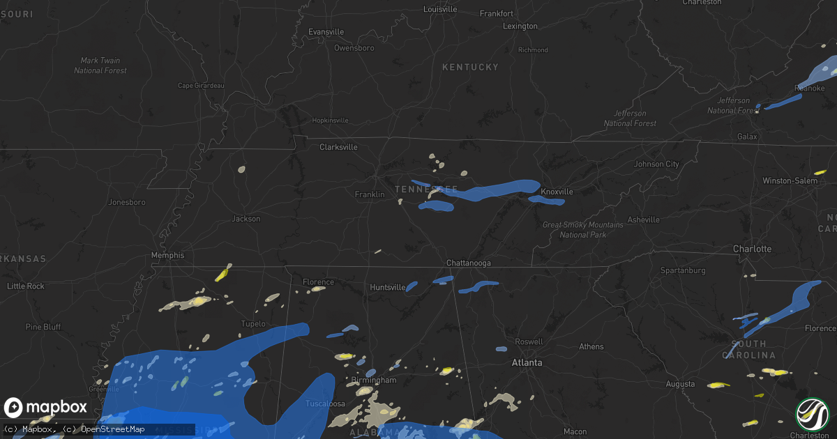
Hail Map in Tennessee on May 4, 2021
Get this storm
May 4 map
$229
one time, instant access
Download today. No call, no setup
Keep the $229
Bought the map and want the full workflow? Apply the entire $229 to a subscription within 7 days. None of it is wasted.
Every map, not just this one
This buys you this map. Subscription and you get every map we run, in the markets you choose from a few cities to whole states to nationwide. Plus real-time alerts the moment a storm fires.
Contact data
Name, contact info, occupancy, even credit band for addresses in the footprint. You go from where it hit to who to call.
Become the source they trust
Unlimited branding weather history reports on demand. You already have the documented answer ready for the property owner, and you are the one who showed up with it.
Property data and RoofTrace estimates
Pull up any address you have got, its value and the exact code rules for that jurisdiction, straight from One Click Code. Then RoofTrace estimates the squares, pitch, and roof value, priced the way you price.
Storm reports in Tennessee
Tennessee
| Date | Description |
|---|---|
| 05/04/202110:00 AM CDT | Several trees down in the sevierville area. |
| 05/04/20219:55 AM CDT | Trees down along the foothills parkway. |
| 05/04/20219:10 AM CDT | Couple trees down. |
| 05/04/20218:55 AM CDT | Numerous trees down and trailer blown over in the pikeville area. |
| 05/04/20218:50 AM CDT | Multiple homes damaged. |
| 05/04/20218:45 AM CDT | Several trees down along hwy 62 in the chestnut ridge community. |
| 05/04/20218:45 AM CDT | Corrects previous tstm wnd dmg report from 3 w deerlodge. Several trees down on hwy 62 in the chestnut ridge community. |
| 05/04/20218:38 AM CDT | Trees down on summerfield road and near south cumberland visitors center |
| 05/04/20218:30 AM CDT | Dozens of trees were blown down around the heatherhurst golf course with some trees falling onto homes and across roads. |
| 05/04/20218:15 AM CDT | Multiple trees down in pleasant hill |
| 05/04/20218:07 AM CDT | This small ef-0 tornado touched down on the north side of sparta near franklin avenue and spring street. Moving southeast... The tornado heavily damaged a barn on rober |
| 05/04/20218:05 AM CDT | Trees and power lines were blown down on hickerson road |
| 05/04/20218:04 AM CDT | Numerous trees were blown down along jones valley road |
| 05/04/20218:03 AM CDT | Severe straight-line winds caused significant damage on the west side of sparta along old smithville highway and highway 70. Numerous trees were blown down... Outbuildi |
| 05/04/20217:58 AM CDT | At 1258 AM CDT, a severe thunderstorm was located near Red Boiling Springs, or 11 miles northwest of Gainesboro, moving east at 25 mph. HAZARD...Quarter size hail. SOURCE...Radar indicated. IMPACT...Damage to vehicles is expected. Locations impacted include... Celina, Red Boiling Springs, Boles, Whitleyville and Moss. |
| 05/04/20217:47 AM CDT | Trees downs and some roof damage in smithville |
| 05/04/20217:47 AM CDT | Tree down along windle community rd near puncheon creek |
| 05/04/20217:45 AM CDT | Trees down and some structural damage of homes in smithville and also toward flago bridge in the holliday haven community |
| 05/04/20217:45 AM CDT | Tree down across road near short mountain in ne cannon co |
| 05/04/20217:43 AM CDT | This ef-0 tornado touched down along coconut ridge road north of smithville... Blowing down several trees. Moving southeast... The tornado crossed highway 56 and moved |
| 05/04/20217:26 AM CDT | At 1226 AM CDT, a severe thunderstorm was located 8 miles northwest of Red Boiling Springs, moving northeast at 45 mph. HAZARD...60 mph wind gusts and quarter size hail. SOURCE...Radar indicated. IMPACT...Hail damage to vehicles is expected. Expect wind damage to roofs, siding, and trees. Locations impacted include... Tompkinsville, Gamaliel, Meshack, Persimmon, Bugtussle, Forkton, Gum Tree, Blythe, Harlan Crossroads and Freetown. |
| 05/04/20217:25 AM CDT | At 1224 AM CDT, a severe thunderstorm was located near Lafayette, moving east at 30 mph. HAZARD...Quarter size hail. SOURCE...Radar indicated. IMPACT...Damage to vehicles is expected. Locations impacted include... Lafayette, Red Boiling Springs, Boles, Whitleyville and Bugtussle. |
| 05/04/20217:24 AM CDT | A large barn was destroyed and another barn had its roof partially blown off at gilmore livestock on highway 231 |
| 05/04/20217:22 AM CDT | Porch and part of metal roof blown of home on big springs road. Numerous trees also blown down with one falling on a car. Several nearby homes also suffered minor damag |
| 05/04/20217:20 AM CDT | This small... Brief tornado touched down on the south side of alexandria. Security video cameras at a home on old liberty road captured the tornado as the roof and back |
| 05/04/20217:19 AM CDT | Large metal barn destroyed and grain bin pushed off foundation on mankin road |
| 05/04/20217:10 AM CDT | Power poles snapped in half along with 12 to 18 inch trees snapped along 41 between 31w split and willamson. Lines down and trees down. |
| 05/04/20217:04 AM CDT | Several trees were blown down around 3 homes at 5765 nashville highway |
| 05/04/20216:25 AM CDT | At 1124 AM EDT, a severe thunderstorm was located over Mill Creek, or near Dalton, moving east at 55 mph. HAZARD...60 mph wind gusts. SOURCE...Radar indicated. IMPACT...Expect damage to roofs, siding, and trees. Locations impacted include... Dalton, Chatsworth, Varnell, Eton, Tunnel Hill, Crandall, Sumac, Wood Station, Rocky Face, Gregory, Mill Creek, Conasauga Lake, Tennga, Beaumont, Beaverdale, Dawnville, Villanow, Cisco and Fort Mountain State Park. |
| 05/04/20216:10 AM CDT | At 1110 AM EDT, severe thunderstorms were located along a line extending from near Dandridge to near Pigeon Forge to near Gatlinburg to near Smoky Mountains-Fontana Area, moving east at 40 mph. HAZARD...60 mph wind gusts. SOURCE...Radar indicated. IMPACT...Expect damage to roofs, siding, and trees. Locations impacted include... Sevierville, Newport, Gatlinburg, Dandridge, Pigeon Forge, Parrottsville, Smoky Mountains-Newfound Gap, Smoky Mountains-Fontana Area, Smoky Mountains-Balsam Mountain and Pittman Center.This includes Interstate 40 in Tennessee between mile markers 429 and451. |
| 05/04/20215:57 AM CDT | At 1056 AM EDT, severe thunderstorms were located along a line extending from 10 miles west of Jefferson City to 12 miles west of Gatlinburg to 13 miles northwest of Robbinsville to 10 miles south of Madisonville, moving east at 40 mph. HAZARD...60 mph wind gusts and quarter size hail. SOURCE...Radar indicated. IMPACT...Minor hail damage to vehicles is expected. Expect wind damage to trees and power lines. Locations impacted include... Bryson City, Robbinsville, Cherokee, Town Of Santeetlah, Smoky Mountains-Newfound Gap, Smoky Mountains-Fontana Area, Lake Santeetlah, Smoky Mountains-Balsam Mountain, Fontana Lake and Smoky Mountains-Big Creek. |
| 05/04/20215:42 AM CDT | At 1042 AM EDT, a severe thunderstorm was located over Higdon, or 7 miles southeast of Bridgeport, moving east at 50 mph. HAZARD...60 mph wind gusts and penny size hail. SOURCE...Radar indicated. IMPACT...Expect damage to roofs, siding, and trees. Locations impacted include... Ringgold, Trenton, Fort Oglethorpe, Rossville, Chickamauga, Lookout Mountain, Blue Spring, Fairview, Chattanooga Valley, Hooker, Cloudland Canyon State Park, Cooper Heights, Rock Spring, Rising Fawn, Noble, Lakeview, Wood Station, Indian Springs, Graysville and Cole City. |
| 05/04/20215:03 AM CDT | At 1002 AM EDT, severe thunderstorms were located along a line extending from Oliver Springs to near Kingston to near Fairview, moving east at 55 mph. HAZARD...60 mph wind gusts and penny size hail. SOURCE...Radar indicated. IMPACT...Expect damage to roofs, siding, and trees. Locations impacted include... Knoxville, Oak Ridge, Maryville, Lenoir City, Alcoa, Kingston, Loudon, Farragut, Fairview and Oliver Springs.This includes the following highways... Interstate 40 in Tennessee between mile markers 354 and 388. Interstate 75 in Tennessee between mile markers 67 and 84. |
| 05/04/20214:48 AM CDT | At 947 AM EDT/847 AM CDT/, a severe thunderstorm was located over Pikeville, moving east at 40 mph. HAZARD...60 mph wind gusts and nickel size hail. SOURCE...Radar indicated. IMPACT...Expect damage to roofs, siding, and trees. Locations impacted include... Dayton, Pikeville, Graysville, Evensville, Palio, Stinging Fork Falls State Park, Old Washington and Brayton. |
| 05/04/20214:37 AM CDT | At 937 AM EDT/837 AM CDT/, severe thunderstorms were located along a line extending from 11 miles west of Wartburg to near Fairfield Glade to 13 miles northeast of Spencer, moving east at 35 mph. HAZARD...60 mph wind gusts and penny size hail. SOURCE...Radar indicated. IMPACT...Expect damage to roofs, siding, and trees. Locations impacted include... Oak Ridge, Kingston, Rockwood, Wartburg, Fairview, Oliver Springs, Spring City, Midtown, Harriman and Oakdale.This includes Interstate 40 in Tennessee between mile markers 341 and358. |
| 05/04/20214:04 AM CDT | At 904 AM CDT, a severe thunderstorm was located near Skyline, or 11 miles northwest of Scottsboro, moving northeast at 65 mph. HAZARD...60 mph wind gusts and quarter size hail. SOURCE...Radar indicated. IMPACT...Hail damage to vehicles is expected. Expect wind damage to roofs, siding, and trees. Locations impacted include... Scottsboro, Bridgeport, Stevenson, Hollywood, Skyline, Woodville, Pleasant Groves, Hytop, Bass and Lim Rock. |
| 05/04/20213:05 AM CDT | At 805 AM CDT, a severe thunderstorm was located 7 miles south of Jamestown, moving northeast at 35 mph. HAZARD...60 mph wind gusts and penny size hail. SOURCE...Radar indicated. IMPACT...Expect damage to roofs, siding, and trees. Locations impacted include... Crossville, Jamestown, Fairfield Glade, Monterey, Crab Orchard, Allardt, Pleasant Hill, Grimsley, Slate Springs, Pall Mall, Clarkrange, Crawford and Pickett State Park.This includes Interstate 40 between mile markers 302 and 328. |
| 05/04/20212:53 AM CDT | At 753 AM CDT, severe thunderstorms were located along a line extending from 6 miles southeast of Smithville to near Tullahoma, moving east at 50 mph. HAZARD...60 mph wind gusts. SOURCE...Radar indicated. IMPACT...Expect damage to roofs, siding, and trees. Locations impacted include... McMinnville, Crossville, Manchester, Sparta, Spencer, Tullahoma, Gruetli-Laager, Altamont, Coalmont, Morrison, Palmer, Pleasant Hill, Doyle, Beersheba Springs, Centertown, Viola, Virgin Falls State Natural Area, Rock Island State Park, Summitville and Fall Creek Falls State Park.This includes Interstate 24 between mile markers 109 and 123. |
| 05/04/20212:38 AM CDT | At 738 AM CDT, a severe thunderstorm was located near Fayetteville, moving east at 50 mph. HAZARD...60 mph wind gusts and quarter size hail. SOURCE...Radar indicated. IMPACT...Hail damage to vehicles is expected. Expect wind damage to roofs, siding, and trees. Locations impacted include... Fayetteville, Lynchburg, Petersburg, Tims Ford Lake, Mulberry, Chestnut Ridge, Howell, Belleville, Dellrose and Hurdlow. |
| 05/04/20212:35 AM CDT | At 735 AM CDT, severe thunderstorms were located along a line extending from 6 miles west of Woodbury to 6 miles south of Shelbyville, moving east at 60 mph. HAZARD...60 mph wind gusts. SOURCE...Radar indicated. IMPACT...Expect damage to roofs, siding, and trees. Locations impacted include... Shelbyville, Manchester, Woodbury, Tullahoma, Morrison, Wartrace, Bell Buckle, Centertown, Normandy, Beechgrove, Raus, Summitville, Bradyville and Readyville.This includes Interstate 24 between mile markers 89 and 118. |
| 05/04/20212:09 AM CDT | At 708 PM CDT, a severe thunderstorm was located near Jericho, or near Meeman Shelby Forest State Park, moving east at 40 mph. HAZARD...60 mph wind gusts and quarter size hail. SOURCE...Radar indicated. IMPACT...Hail damage to vehicles is expected. Expect wind damage to roofs, siding, and trees. Locations impacted include... Bartlett, Collierville, Germantown, West Memphis, Marion, Millington, Meeman Shelby Forest State Park, Cordova, Memphis, Lakeland, Arlington, Sunset, Ellendale, Frayser, Midtown Memphis, Downtown Memphis, Eads, Oakland, Piperton and Gallaway. |
| 05/04/20211:29 AM CDT | At 629 PM CDT, a severe thunderstorm was located 8 miles north of Earle, moving east at 40 mph. HAZARD...60 mph wind gusts and quarter size hail. SOURCE...Radar indicated. IMPACT...Hail damage to vehicles is expected. Expect wind damage to roofs, siding, and trees. Locations impacted include... West Memphis, Marion, Earle, Parkin, Tyronza, Meeman Shelby Forest State Park, Memphis, Joiner, Crawfordsville, Sunset, Gilmore, Jericho, Dixonville, Turrell, Clarkedale, Birdsong, Three Forks, Dimple, Booker and Deckerville. |
| 05/04/20211:16 AM CDT | At 615 AM CDT, severe thunderstorms were located along a line extending from near Portland to Forest Hills, moving east at 45 mph. HAZARD...60 mph wind gusts and penny size hail. SOURCE...Radar indicated. IMPACT...Expect damage to roofs, siding, and trees. Locations impacted include... Gallatin, Lebanon, Lafayette, Hartsville, Hendersonville, La Vergne, Mount Juliet, Westmoreland, Watertown, Hermitage, Rural Hill, Belinda City, Antioch, Green Hill, Tuckers Crossroads, Bethpage, Dixon Springs, Oak Grove, Bledsoe Creek State Park and Dickerson Chapel Recreation Area.This includes the following highways... Interstate 40 between mile markers 218 and 249. Interstate 840 between mile markers 67 and 76. |
| 05/04/20211:10 AM CDT | At 610 AM CDT, severe thunderstorms were located along a line extending from 10 miles southwest of Memphis Junction to 7 miles north of Cross Plains, moving east at 15 mph. HAZARD...60 mph wind gusts and penny size hail. SOURCE...Radar indicated. IMPACT...Expect damage to roofs, siding, and trees. Locations impacted include... Hillsdale, Black Jack, Neosheo, Clare, Geddes, Mcelroy Ford, Pope, Butlersville, Trammel and Salmons. |
| 05/04/20211:05 AM CDT | At 605 AM EDT, a severe thunderstorm was located 9 miles southeast of Maryville, moving east at 25 mph. HAZARD...60 mph wind gusts and quarter size hail. SOURCE...Radar indicated. IMPACT...Hail damage to vehicles is expected. Expect wind damage to roofs, siding, and trees. Locations impacted include... Gatlinburg, Pigeon Forge, Townsend, Wears Valley, Walland, Cades Cove, Elkmont, Roundtop Mountain State Park, Happy Valley and Great Smoky Mountains National Park. |
| 05/04/202112:39 AM CDT | At 539 AM CDT, severe thunderstorms were located along a line extending from 9 miles east of Guthrie to near White Bluff, moving east at 45 mph. HAZARD...60 mph wind gusts and penny size hail. SOURCE...Radar indicated. IMPACT...Expect damage to roofs, siding, and trees. Locations impacted include... Springfield, Ashland City, Nashville, Madison, Hendersonville, Goodlettsville, White House, Millersville, Greenbrier, Forest Hills, Oak Hill, Coopertown, White Bluff, Belle Meade, Kingston Springs, Lakewood, Pegram, Ridgetop, Cross Plains and Burns.This includes the following highways... Interstate 40 between mile markers 185 and 218. Interstate 65 between mile markers 77 and 121. Interstate 24 between mile markers 19 and 57. |
| 05/04/202112:06 AM CDT | At 505 AM CDT, severe thunderstorms were located along a line extending from 6 miles northwest of Crofton to near Fort Campbell, moving east at 50 mph. HAZARD...60 mph wind gusts and penny size hail. SOURCE...Radar indicated. IMPACT...Expect damage to roofs, siding, and trees. Locations impacted include... Hopkinsville, Oak Grove, Elkton, Fort Campbell.This includes the following highways... Interstate 24 in Kentucky between Mile Markers 71 and 92. Interstate 69 in Kentucky between Mile Markers 97 and 106. Western Kentucky Parkway between Mile Markers 39 and 41. Pennyrile Parkway between Mile Markers 1 and 34. |
| 05/04/202112:02 AM CDT | At 501 AM CDT, severe thunderstorms were located along a line extending from McEwen to Parsons, moving east at 50 mph. HAZARD...60 mph wind gusts and quarter size hail. SOURCE...Radar indicated. IMPACT...Hail damage to vehicles is expected. Expect wind damage to roofs, siding, and trees. Locations impacted include... Dickson, Ashland City, Waverly, Centerville, Camden, White Bluff, Kingston Springs, New Johnsonville, McEwen, Burns, Hurricane Mills, Charlotte, Lobelville, Vanleer, Bon Aqua, Lyles, Bucksnort, Pinewood, Nunnelly and I-40 Near The Tennessee River.This includes the following highways... Interstate 40 between mile markers 136 and 180. Interstate 840 between mile markers 1 and 3. |
| 05/03/202111:43 PM CDT | At 442 AM CDT, severe thunderstorms were located along a line extending from near Springville to near Blue Goose, moving northeast at 35 mph. HAZARD...60 mph wind gusts and quarter size hail. SOURCE...Radar indicated. IMPACT...Hail damage to vehicles is expected. Expect wind damage to roofs, siding, and trees. Locations impacted include... Lexington, Huntingdon, Camden, Natchez Trace State Park, Natchez Trace State Forest, New Johnsonville, Bruceton, Blue Goose, Vale, Bargerton, Wildersville, Springville, Parkers Crossroads, Hollow Rock, Big Sandy, Henry, Clarksburg, Hickory Flat, Dollar and Old Springville. |
| 05/03/202111:40 PM CDT | At 440 AM EDT, a severe thunderstorm was located over Oak Ridge, moving east at 30 mph. HAZARD...60 mph wind gusts and quarter size hail. SOURCE...Radar indicated. IMPACT...Hail damage to vehicles is expected. Expect wind damage to roofs, siding, and trees. Locations impacted include... Knoxville, Oak Ridge, Clinton, Oliver Springs, Norris, Bearden, Powell, Karns and Andersonville.This includes the following highways... Interstate 40 in Tennessee between mile markers 376 and 385. Interstate 75 in Tennessee between mile markers 110 and 123. |
| 05/03/202111:08 PM CDT | At 408 AM CDT, severe thunderstorms were located along a line extending from near Reidland to 6 miles southeast of Lynnville, moving east at 50 mph. HAZARD...60 mph wind gusts and nickel size hail. SOURCE...Radar indicated. IMPACT...Expect damage to roofs, siding, and trees. Locations impacted include... Murray, Benton, Cadiz, Land Between The Lakes Area, Canton, Rockcastle, Hardin, Hazel, New Concord, Linton, Kirksey, Brewers, Aurora, Harris Grove and Crossland.This includes the following highways... Interstate 24 in Kentucky between Mile Markers 54 and 55, andbetween Mile Markers 58 and 70. Interstate 69 in Kentucky between Mile Markers 35 and 47. |
| 05/03/202110:53 PM CDT | At 353 AM EDT, a severe thunderstorm was located near Midtown, or 7 miles north of Kingston, moving east at 25 mph. HAZARD...60 mph wind gusts and quarter size hail. SOURCE...Radar indicated. IMPACT...Hail damage to vehicles is expected. Expect wind damage to roofs, siding, and trees. Locations impacted include... Oak Ridge, Oliver Springs, Harriman, Oakdale, Coalfield and Dearmond. |
| 05/03/202110:35 PM CDT | At 332 AM CDT, an area of severe thunderstorms was located from near Bardwell south through Clinton and Cayce, moving east at 45 mph. HAZARD...60 mph wind gusts and quarter size hail. SOURCE...Radar indicated. IMPACT...Hail damage to vehicles is expected. Expect wind damage to roofs, siding, and trees. Locations impacted include... Mayfield, Fulton, Clinton, Bardwell, Cayce, Lynnville, Fulgham, Sedalia, Wingo, Arlington, Water Valley, Columbus, Lowes, Fancy Farm and Symsonia.This includes Interstate 69 in Kentucky between Mile Markers 1 and33. |
| 05/03/202110:28 PM CDT | At 327 AM CDT, severe thunderstorms were located along a line extending from near Hickman to near Troy to 6 miles northeast of Chestnut Bluff, moving east at 65 mph. HAZARD...60 mph wind gusts. SOURCE...Radar indicated. IMPACT...Expect damage to roofs, siding, and trees. Locations impacted include... Martin, Union City, Milan, Trenton, Fulton, Newbern, Dresden, South Fulton, Dyer, Greenfield, Troy, Kenton, Rutherford, Obion, Bradford, Sharon, Atwood, Latham, Clayton and Eaton. |
| 05/03/202110:22 PM CDT | At 322 AM CDT, a severe thunderstorm was located near Celina, Tennessee, moving northeast at 25 mph. HAZARD...Quarter size hail. SOURCE...Radar indicated. IMPACT...Damage to vehicles is expected. Locations impacted include... Albany, Burkesville, Littrell, Modoc, Green Grove, Bow, Hobart, Peytonsburg, Hegira, and Kettle. |
| 05/03/202110:10 PM CDT | At 309 AM EDT, a severe thunderstorm was located near Fairfield Glade, or 8 miles northwest of Rockwood, moving east at 20 mph. HAZARD...Quarter size hail. SOURCE...Radar indicated. IMPACT...Damage to vehicles is expected. Locations impacted include... Oak Ridge, Kingston, Rockwood, Midtown, Harriman, Oakdale, Coalfield, Pine Orchard, Petros and Dearmond.This includes Interstate 40 in Tennessee between mile markers 341 and358. |
| 05/03/202110:00 PM CDT | At 300 PM CDT, a severe thunderstorm was located over Canaan, or 18 miles northwest of Ripley, moving northeast at 20 mph. HAZARD...Quarter size hail. SOURCE...Radar indicated. IMPACT...Damage to vehicles is expected. Locations impacted include... Canaan, Walnut, Middleton, Grand Junction, Saulsbury, Rogers Springs, Chalybeate, Brody, Lisbon, New Canaan, Brownfield, Hamilton and Tiplersville. |
| 05/03/20219:34 PM CDT | At 234 AM CDT, severe thunderstorms were located along a line extending from near Caraway to near Parkin, moving east at 65 mph. HAZARD...60 mph wind gusts. SOURCE...Radar indicated. IMPACT...Expect damage to roofs, siding, and trees. Locations impacted include... Osceola, Marked Tree, Lepanto, Wilson, Tyronza, Keiser, Joiner, Dyess, Gilmore, Bassett, Marie, Turrell, Etowah, Birdsong, Three Forks, Dimple, Deckerville, Evadale, Menesha and Grider. |
| 05/03/20219:25 PM CDT | At 224 AM CDT, severe thunderstorms were located along a line extending from near Holcomb to near Cardwell, moving east at 45 mph. HAZARD...60 mph wind gusts and quarter size hail. SOURCE...Radar indicated. IMPACT...Hail damage to vehicles is expected. Expect wind damage to roofs, siding, and trees. Locations impacted include... Blytheville, Kennett, Osceola, Caruthersville, Malden, Piggott, Gosnell, Manila, Portageville, Hayti, Steele, Leachville, Campbell, Senath, Caraway, Luxora, Cardwell, Hornersville, Holcomb and Hayti Heights. |
| 05/03/20219:07 PM CDT | At 207 AM CDT, a severe thunderstorm was located near Fairfield Glade, or 10 miles northwest of Rockwood, moving east at 20 mph. HAZARD...Quarter size hail. SOURCE...Radar indicated. IMPACT...Damage to vehicles is expected. Locations impacted include... Fairfield Glade and Crab Orchard. This includes Interstate 40 between mile markers 329 and 331, andbetween mile markers 335 and 340. |
| 05/03/20219:02 PM CDT | At 201 AM CDT, severe thunderstorms were located along a line extending from near Sedalia to Lilbourn, moving northeast at 60 mph. HAZARD...60 mph wind gusts and quarter size hail. SOURCE...Radar indicated. IMPACT...Hail damage to vehicles is expected. Expect wind damage to roofs, siding, and trees. Locations impacted include... Mayfield, East Prairie, New Madrid, Fulton, Hickman, Clinton, Bardwell, Towosahgy State Historic Site, Big Oak Tree State Park, Hunter-Dawson State Historic Site, Marston, Howardville, Wyatt, Anniston, Cayce, Dorena, Fulgham, Sedalia, Farrenburg and Wingo.This includes the following highways... Interstate 69 in Kentucky between Mile Markers 1 and 33. Interstate 55 between Mile Markers 39 and 50. |
| 05/03/20218:34 PM CDT | At 134 AM CDT, a severe thunderstorm was located over Celina, moving east at 30 mph. HAZARD...Quarter size hail. SOURCE...Radar indicated. IMPACT...Damage to vehicles is expected. Locations impacted include... Livingston, Celina, Dale Hollow Lake and Standing Stone State Park. |
All States Impacted by Hail Map on May 4, 2021
Cities Impacted by Hail Map on May 4, 2021
- Saulsbury, TN
- Walnut, MS
- Ashland, MS
- Michigan City, MS
- Morton, MS
- Pelahatchie, MS
- Sulphur, LA
- French Settlement, LA
- Maurepas, LA
- Saint Amant, LA
- Clanton, AL
- Verbena, AL
- Billingsley, AL
- Martindale, TX
- Milam, WV
- Bergton, VA
- Moorefield, WV
- Waterford, MS
- Como, MS
- Holly Springs, MS
- Abbeville, MS
- Ruleville, MS
- Doddsville, MS
- Cleveland, MS
- Valley, AL
- Opelika, AL
- Hamilton, GA
- Cusseta, AL
- West Point, GA
- Salem, AL
- Smithville, TX
- Palacios, TX
- Florence, MS
- Frierson, LA
- Stonewall, LA
- Quicksburg, VA
- New Market, VA
- Timberville, VA
- Mount Jackson, VA
- Weogufka, AL
- Equality, AL
- Eclectic, AL
- Rockford, AL
- Alexander City, AL
- Elmore, AL
- Titus, AL
- Prattville, AL
- Deatsville, AL
- Wetumpka, AL
- Millbrook, AL
- Marbury, AL
- Ashburn, GA
- Pheba, MS
- Maben, MS
- Lamar, MS
- Bastrop, TX
- Red Rock, TX
- Cedar Creek, TX
- Florien, LA
- Steeles Tavern, VA
- Greenville, VA
- Raphine, VA
- Heflin, AL
- Anniston, AL
- Sardis, MS
- Crenshaw, MS
- Wilsonville, AL
- Columbiana, AL
- Gary, TX
- Tenaha, TX
- Timpson, TX
- Cameron, SC
- Effie, LA
- Jonesville, LA
- Marksville, LA
- Pennington, TX
- Groveton, TX
- Apple Springs, TX
- Kennard, TX
- Nacogdoches, TX
- Lafayette, AL
- Camp Hill, AL
- Five Points, AL
- Lanett, AL
- Moorhead, MS
- Indianola, MS
- Bienville, LA
- Crosby, MS
- Brent, AL
- Williston, SC
- Bedford, VA
- Big Island, VA
- Rolling Fork, MS
- Glen Allan, MS
- Hollandale, MS
- Mayersville, MS
- Anguilla, MS
- Lumberton, TX
- Kountze, TX
- Lockhart, TX
- Caldwell, TX
- Jasper, AL
- Vesuvius, VA
- Tyro, VA
- Montebello, VA
- Draper, VA
- Hamburg, AR
- Ragley, LA
- Starks, LA
- Lake Charles, LA
- Longville, LA
- Mittie, LA
- Dequincy, LA
- Oakdale, LA
- Kinder, LA
- Singer, LA
- Oberlin, LA
- Dry Creek, LA
- Iowa, LA
- Reeves, LA
- Warrior, AL
- Dora, AL
- Empire, AL
- Brenham, TX
- Ruffin, SC
- Islandton, SC
- Lovelady, TX
- Trinity, TX
- Amite, LA
- Holden, LA
- Walker, LA
- Dale, TX
- Dermott, AR
- Goode, VA
- Fulks Run, VA
- Broadway, VA
- Mathias, WV
- Criders, VA
- Middlebrook, VA
- Kyle, TX
- Philadelphia, MS
- Carthage, MS
- Jemison, AL
- Luray, VA
- Gloster, MS
- Centreville, MS
- Baytown, TX
- Brandywine, WV
- Franklin, WV
- Greenville, MS
- Windsor, SC
- Blackville, SC
- Parrish, AL
- Cordova, AL
- Montrose, AR
- Crossett, AR
- Woodville, MS
- Batchelor, LA
- Bessemer, AL
- Birmingham, AL
- McCalla, AL
- Huntington, TX
- Dayton, TX
- Amissville, VA
- Sperryville, VA
- Flint Hill, VA
- Washington, VA
- Woodville, VA
- Castleton, VA
- Saltillo, MS
- Jackson, MS
- Crystal Springs, MS
- Giddings, TX
- La Grange, TX
- Summerton, SC
- Pinewood, SC
- Gibsland, LA
- Lufkin, TX
- Greensburg, LA
- Orangeburg, SC
- Pleasant Shade, TN
- Haughton, LA
- Elm Grove, LA
- Lake, MS
- Browns Summit, NC
- Greensboro, NC
- Summerfield, NC
- Canton, MS
- Brandon, MS
- Hiwassee, VA
- Roxie, MS
- Meadville, MS
- Pulaski, MS
- Forest, MS
- Raleigh, MS
- Fairfield, VA
- Buena Vista, VA
- Lexington, VA
- Ledbetter, TX
- Huffman, TX
- Lexington, TX
- Rockdale, TX
- Lagrange, GA
- Camden, SC
- Jamestown, LA
- Castor, LA
- Cary, MS
- Burton, TX
- Calera, AL
- Shelby, AL
- Potts Camp, MS
- Oxford, MS
- Shreveport, LA
- McDade, TX
- Elgin, TX
- Carmine, TX
- Satartia, MS
- Sylacauga, AL
- Vidalia, LA
- Ackerman, MS
- Eupora, MS
- Mathiston, MS
- Crosby, TX
- Hickory Flat, MS
- Myrtle, MS
- Madison, MS
- Ridgeland, MS
- Clinton, MS
- Camden, MS
- Woodbury, TN
- Summit, MS
- Smithdale, MS
- Simmesport, LA
- Lettsworth, LA
- Jacksonville, AL
- Eagle Rock, VA
- Clifton Forge, VA
- Booneville, MS
- Georgetown, MS
- Harrisville, MS
- Huger, SC
- Cordesville, SC
- Moncks Corner, SC
- Taylorsville, MS
- Eros, LA
- West Monroe, LA
- Hornbeck, LA
- Woodbridge, VA
- Keithville, LA
- Marietta, MS
- Bastrop, LA
- Saint Matthews, SC
- Jamaica, VA
- Lancaster, VA
- Little Plymouth, VA
- Church View, VA
- Urbanna, VA
- Water View, VA
- Bentonia, MS
- Vaughan, MS
- McCarley, MS
- Winona, MS
- Coila, MS
- Elloree, SC
- Collinston, LA
- Mer Rouge, LA
- Tallulah, LA
- Watson, AR
- Vidor, TX
- Hazlehurst, MS
- Kingsbury, TX
- San Marcos, TX
- Noxapater, MS
- New Albany, MS
- South Mills, NC
- Mendenhall, MS
- Magee, MS
- Cheneyville, LA
- Denham Springs, LA
- Murfreesboro, TN
- Mount Olive, MS
- Mize, MS
- Bryan, TX
- Cherokee, AL
- Benton, MS
- Waverly, AL
- Dunnsville, VA
- Baldwyn, MS
- Saint Martinville, LA
- Round Top, TX
- Brooks, GA
- Senoia, GA
- Rayville, LA
- Gay, GA
- Luthersville, GA
- Greenville, GA
- Catherine, AL
- Camden, AL
- Edinburg, VA
- Orkney Springs, VA
- Amherst, VA
- Poplar Branch, NC
- Grandy, NC
- Collinsville, MS
- Rockbridge Baths, VA
- Tuscumbia, AL
- Liberty, TN
- Dowelltown, TN
- Smithville, TN
- Union, MS
- Decatur, MS
- Sunbury, NC
- Corapeake, NC
- Little Rock, MS
- Chunky, MS
- Hickory, MS
- Meridian, MS
- Newton, MS
- New Braunfels, TX
- Centreville, AL
- Banner, MS
- Water Valley, MS
- Somerville, TX
- Columbia, NC
- Navasota, TX
- Marion, LA
- Braxton, MS
- Pearl, MS
- Terry, MS
- Byram, MS
- Richland, MS
- Louin, MS
- Starkville, MS
- Suffolk, VA
- Farmerville, LA
- Hogansville, GA
- Franklin, GA
- Coffeeville, MS
- Itta Bena, MS
- Greenwood, MS
- Schlater, MS
- Bay Springs, MS
- De Kalb, MS
- Eutaw, AL
- Maxwell, TX
- Seguin, TX
- Bruce, MS
- Sunflower, MS
- Manning, SC
- Sharpsburg, GA
- Grantville, GA
- Moreland, GA
- Newnan, GA
- Warrenton, VA
- Catlett, VA
- Epps, LA
- Dadeville, AL
- Bunkie, LA
- Paige, TX
- Delta, AL
- Leesville, LA
- Bryans Road, MD
- Inverness, MS
- Tappahannock, VA
- Champlain, VA
- Ralph, AL
- Gore Springs, MS
- Grenada, MS
- Saint Landry, LA
- Deridder, LA
- Fort Polk, LA
- Pitkin, LA
- Maplesville, AL
- Thorsby, AL
- Brierfield, AL
- Pelham, AL
- Childersburg, AL
- Alabaster, AL
- Montevallo, AL
- Helena, AL
- Randolph, AL
- Bude, MS
- Liberty, MS
- Cedarbluff, MS
- West Point, MS
- Golden, MS
- Oakman, AL
- Adger, AL
- Trussville, AL
- Odenville, AL
- Monroe, LA
- Lake Village, AR
- Flora, MS
- Lugoff, SC
- Pontotoc, MS
- Accokeek, MD
- Indian Head, MD
- Muscle Shoals, AL
- Leighton, AL
- Catawba, SC
- Rock Hill, SC
- Lorton, VA
- Ragland, AL
- Pell City, AL
- Pinola, MS
- Livingston, LA
- Buchanan, VA
- Nokesville, VA
- Waldorf, MD
- Manassas, VA
- Dumfries, VA
- Warsaw, VA
- Granville, TN
- Gainesboro, TN
- Salters, SC
- Ethel, LA
- Clinton, LA
- Slaughter, LA
- McGehee, AR
- Arkansas City, AR
- Lancaster, SC
- Ruth, MS
- Jeanerette, LA
- Boligee, AL
- Lake Providence, LA
- Boyle, MS
- Cottageville, SC
- Ridgeville, SC
- Natchez, MS
- Manor, TX
- Corolla, NC
- Shiloh, NC
- Downsville, LA
- Moreauville, LA
- Stuarts Draft, VA
- Lyndhurst, VA
- Fayetteville, TN
- Frankewing, TN
- Leland, MS
- West Blocton, AL
- Townley, AL
- Charleston, SC
- Goose Creek, SC
- Ladson, SC
- North Charleston, SC
- Minter City, MS
- Philipp, MS
- Charleston, MS
- Pierre Part, LA
- Oak Ridge, LA
- Sterlington, LA
- Marshall, TX
- Evergreen, LA
- Morrow, LA
- Washington, LA
- Griffin, GA
- Weir, MS
- Newhebron, MS
- Chatham, LA
- Austin, TX
- Waskom, TX
- Oak Grove, LA
- Beulah, MS
- Benoit, MS
- Lawrence, MS
- Conehatta, MS
- Greenfield, TN
- Sharon, TN
- Martin, TN
- McBee, SC
- Monticello, AR
- Springville, AL
- Holcomb, MS
- Bedias, TX
- Adamsville, AL
- Petersburg, WV
- Hearne, TX
- Marshall, VA
- Duck Hill, MS
- Mississippi State, MS
- Duncanville, AL
- Moundville, AL
- Lena, MS
- Ringgold, LA
- Livingston, TX
- Cookeville, TN
- Monterey, TN
- Bossier City, LA
- Chestnut Mound, TN
- Elmwood, TN
- Del Valle, TX
- Shaw, MS
- Ranburne, AL
- Tishomingo, MS
- New Site, MS
- Bernice, LA
- Glasgow, VA
- Natural Bridge, VA
- Oxford, AL
- Yazoo City, MS
- Grand Cane, LA
- Mansfield, LA
- Calhoun, LA
- Jonesboro, LA
- Natchitoches, LA
- Campti, LA
- Goldonna, LA
- Winnfield, LA
- Mangham, LA
- Hollytree, AL
- Woodville, AL
- Paint Rock, AL
- Trenton, AL
- Scottsboro, AL
- Lynn, AL
- Double Springs, AL
- Haleyville, AL
- Houston, AL
- Nauvoo, AL
- Vinemont, AL
- Cullman, AL
- Addison, AL
- Arley, AL
- Logan, AL
- Bryant, AL
- Hollywood, AL
- Higdon, AL
- Stevenson, AL
- Flat Rock, AL
- Trenton, GA
- Rising Fawn, GA
- Pisgah, AL
- Gardendale, AL
- Fultondale, AL
- Mount Olive, AL
- Sumiton, AL
- Fort Deposit, AL
- Honoraville, AL
- Greenville, AL
- Pitts, GA
- Smiths Station, AL
- Preston, GA
- Cataula, GA
- Leslie, GA
- Rochelle, GA
- Ellenton, GA
- Adel, GA
- Reynolds, GA
- Pike Road, AL
- Oglethorpe, GA
- Omaha, GA
- De Soto, GA
- Camilla, GA
- Alapaha, GA
- Fitzgerald, GA
- Baconton, GA
- Ocilla, GA
- Warwick, GA
- Tallassee, AL
- Plains, GA
- Albany, GA
- Poulan, GA
- Andersonville, GA
- Columbus, GA
- Ideal, GA
- Rebecca, GA
- Box Springs, GA
- Ellaville, GA
- Talbotton, GA
- Shiloh, GA
- Oakfield, GA
- Unadilla, GA
- Pinehurst, GA
- Seale, AL
- Booth, AL
- Fitzpatrick, AL
- Hayneville, AL
- Lowndesboro, AL
- Buena Vista, GA
- Weston, GA
- Phenix City, AL
- Smithville, GA
- Auburn University, AL
- Georgetown, GA
- Tuskegee, AL
- Notasulga, AL
- Sparks, GA
- Ramer, AL
- Newton, GA
- Americus, GA
- Sale City, GA
- Bronwood, GA
- Cobb, GA
- Richland, GA
- Hardaway, AL
- Ty Ty, GA
- Ellerslie, GA
- Tifton, GA
- Sycamore, GA
- Enigma, GA
- Arabi, GA
- Fort Benning, GA
- Hurtsboro, AL
- Pittsview, AL
- Vienna, GA
- Cusseta, GA
- Fort Mitchell, AL
- Mauk, GA
- Tuskegee Institute, AL
- Byromville, GA
- Tyler, AL
- Fort Davis, AL
- Kellyton, AL
- Shellman, GA
- Autaugaville, AL
- Norman Park, GA
- Mathews, AL
- Rupert, GA
- Nashville, GA
- Sumner, GA
- Montgomery, AL
- Chula, GA
- Parrott, GA
- Junction City, GA
- Leesburg, GA
- Fortson, GA
- Marshallville, GA
- Shorter, AL
- Lumpkin, GA
- Upatoi, GA
- Eufaula, AL
- Clayton, AL
- Lenox, GA
- Butler, GA
- Midway, AL
- Moultrie, GA
- Jacksons Gap, AL
- Montezuma, GA
- Cuthbert, GA
- Midland, GA
- Auburn, AL
- Waverly Hall, GA
- Omega, GA
- Hatchechubbee, AL
- Doerun, GA
- Cordele, GA
- Morris, GA
- Sylvester, GA
- Cecil, AL
- Dawson, GA
- Hartsfield, GA
- Hope Hull, AL
- Pine Mountain, GA
- Union Springs, AL
- Dalton, GA
- Ringgold, GA
- Chatsworth, GA
- Rocky Face, GA
- La Fayette, GA
- Tunnel Hill, GA
- Rock Spring, GA
- Chickamauga, GA
- Powder Springs, GA
- Dallas, GA
- Hiram, GA
- Culpeper, VA
- Madison, VA
- Leon, VA
- Brightwood, VA
- Reva, VA
- Rochelle, VA
- Pratts, VA
- Arrington, VA
- Pelion, SC
- Columbia, SC
- Lexington, SC
- West Columbia, SC
- Cassatt, SC
- Patrick, SC
- Jefferson, SC
- Bethune, SC
- Cheraw, SC
- Wallace, SC
- Bishopville, SC
- Rockingham, NC
- Hartsville, SC
- Society Hill, SC
- Chesterfield, SC
- Bennettsville, SC
- Elgin, SC
- Hamlet, NC
- Blythewood, SC
- Ridgeway, SC
- Winnsboro, SC
- Norway, SC
- Branchville, SC
- Rowesville, SC
- Bowman, SC
- Clinton, MD
- Temple Hills, MD
- Andrews Air Force Base, MD
- Suitland, MD
- Fort Washington, MD
- Oxon Hill, MD
- Upper Marlboro, MD
- Brandywine, MD
- Coupland, TX
- Weedville, PA
- Pulaski, VA
- Roanoke, VA
- Bent Mountain, VA
- Christiansburg, VA
- Shawsville, VA
- Callaway, VA
- Check, VA
- Pilot, VA
- Radford, VA
- Riner, VA
- Copper Hill, VA
- Monroe, VA
- Troutville, VA
- Natural Bridge Station, VA
- Fincastle, VA
- Cloverdale, VA
- Thaxton, VA
- Coleman Falls, VA
- Montvale, VA
- Blue Ridge, VA
- Daleville, VA
- Salem, VA
- Fort Valley, VA
- Rileyville, VA
- Basye, VA
- Front Royal, VA
- Linden, VA
- Vienna, VA
- Dunn Loring, VA
- Falls Church, VA
- Fairfax, VA
- Spotsylvania, VA
- Secretary, MD
- Vienna, MD
- Great Mills, MD
- Bowling Green, VA
- Colonial Beach, VA
- Ruther Glen, VA
- Valley Lee, MD
- Madison, MD
- California, MD
- Columbia, VA
- Seaford, DE
- Avenue, MD
- Montross, VA
- Lexington Park, MD
- Chaptico, MD
- Crapo, MD
- Lusby, MD
- Fredericksburg, VA
- Hollywood, MD
- Louisa, VA
- Bushwood, MD
- Palmyra, VA
- Mineral, VA
- Church Creek, MD
- Kents Store, VA
- Bumpass, VA
- Trappe, MD
- Ellendale, DE
- Leonardtown, MD
- Newburg, MD
- Troy, VA
- Greenwood, DE
- Port Royal, VA
- Bridgeville, DE
- Issue, MD
- Woolford, MD
- Taylors Island, MD
- Fishing Creek, MD
- Georgetown, DE
- Callaway, MD
- Woodford, VA
- Partlow, VA
- Federalsburg, MD
- Rappahannock Academy, VA
- Abell, MD
- Solomons, MD
- Scottsville, VA
- Hurlock, MD
- Preston, MD
- Linkwood, MD
- Patuxent River, MD
- Park Hall, MD
- Drayden, MD
- Clements, MD
- Mechanicsville, MD
- Loveville, MD
- King George, VA
- Rhodesdale, MD
- Tall Timbers, MD
- Montpelier, VA
- Dowell, MD
- Beaverdam, VA
- East New Market, MD
- Coltons Point, MD
- Cobb Island, MD
- Milford, VA
- Cambridge, MD
- Milton, DE
- Stony Creek, VA
- Jarratt, VA
- Waverly, VA
- Emporia, VA
- Yale, VA
- Carson, VA
- Dinwiddie, VA
- Disputanta, VA
- Fort Monroe, VA
- Zuni, VA
- Smithfield, VA
- Hampton, VA
- Windsor, VA
- Carrollton, VA
- Newport News, VA
- Alexandria, TN
- Watertown, TN
- Oak Ridge, TN
- Harriman, TN
- Rockwood, TN
- Clinton, TN
- Pleasant Hill, TN
- Crab Orchard, TN
- Oliver Springs, TN
- Crossville, TN
- Sparta, TN
- Walling, TN
- Wartburg, TN
- Oakdale, TN
- Rock Island, TN
- Mcminnville, TN
- Bradyville, TN
- Louisville, TN
- Walland, TN
- Farragut, TN
- Maryville, TN
- Seymour, TN
- Rockford, TN
- Knoxville, TN
- Alcoa, TN
- Lenoir City, TN
- Carrollton, MS
- Emelle, AL
- Franklinton, LA
- Lisman, AL
- Mantee, MS
- Louise, MS
- Redwood, MS
- Hamilton, AL
- Akron, AL
- North Carrollton, MS
- Kosciusko, MS
- Dickinson, AL
- Bellamy, AL
- Goodman, MS
- Vina, AL
- Bogue Chitto, MS
- Louisville, MS
- Petal, MS
- Shubuta, MS
- Bailey, MS
- Daleville, MS
- Roseland, LA
- Epes, AL
- Shuqualak, MS
- Sidon, MS
- Raymond, MS
- Brookhaven, MS
- Gainesville, AL
- Newbern, AL
- Lumberton, MS
- Mccomb, MS
- Forkland, AL
- Marion, MS
- Flowood, MS
- Fayette, MS
- Buckatunna, MS
- Gallion, AL
- Ovett, MS
- Lexington, MS
- York, AL
- Edwards, MS
- Orrville, AL
- Quitman, MS
- Fluker, LA
- Loranger, LA
- Bassfield, MS
- Big Creek, MS
- Ward, AL
- Lauderdale, MS
- Kentwood, LA
- Cascilla, MS
- Laurel, MS
- Sumrall, MS
- Hermanville, MS
- Pine Grove, LA
- Sawyerville, AL
- Walthall, MS
- Glendora, MS
- Cottondale, AL
- Houlka, MS
- Tremont, MS
- Silver Creek, MS
- West, MS
- Toomsuba, MS
- Pine Hill, AL
- Smithville, MS
- Greenwood Springs, MS
- Holly Bluff, MS
- Sandy Hook, MS
- Coffeeville, AL
- Durant, MS
- Bellefontaine, MS
- Paulding, MS
- Frankville, AL
- McCall Creek, MS
- Calhoun City, MS
- Jayess, MS
- Foxworth, MS
- Wesson, MS
- Walnut Grove, MS
- Ferriday, LA
- Greensboro, AL
- Whatley, AL
- Safford, AL
- Vossburg, MS
- Rose Hill, MS
- Norwood, LA
- Oak Vale, MS
- Scooba, MS
- Tylertown, MS
- Pennington, AL
- Saint Francisville, LA
- Gordo, AL
- Tuscaloosa, AL
- Bolton, MS
- Fulton, MS
- Port Gibson, MS
- Echola, AL
- Vaiden, MS
- Jackson, LA
- Uniontown, AL
- Gilbertown, AL
- Shannon, MS
- Magnolia, AL
- Coker, AL
- Vardaman, MS
- Macon, MS
- Elrod, AL
- Coy, AL
- Seminary, MS
- Amory, MS
- Buhl, AL
- Kilmichael, MS
- Monticello, MS
- Prairie, MS
- Kokomo, MS
- Saint Stephens, AL
- State Line, MS
- Preston, MS
- Butler, AL
- Hattiesburg, MS
- Pickens, MS
- Newellton, LA
- Needham, AL
- Purvis, MS
- Tinsley, MS
- Ellisville, MS
- Wilson, LA
- Cruger, MS
- Scobey, MS
- Sallis, MS
- Aberdeen, MS
- Moselle, MS
- Thomasville, AL
- Osyka, MS
- Plantersville, MS
- Dixons Mills, AL
- Soso, MS
- Jachin, AL
- Grove Hill, AL
- Silver City, MS
- Hackleburg, AL
- Ethel, MS
- Sondheimer, LA
- Woodland, MS
- Melvin, AL
- Stringer, MS
- Carrollton, AL
- Angie, LA
- Berry, AL
- Husser, LA
- Derma, MS
- Union Church, MS
- Guin, AL
- Detroit, AL
- Sebastopol, MS
- Independence, LA
- Chatom, AL
- Minter, AL
- Vredenburgh, AL
- Lorman, MS
- Utica, MS
- Vicksburg, MS
- Knoxville, AL
- Linden, AL
- Sturgis, MS
- Stewart, MS
- Waterproof, LA
- Heidelberg, MS
- McCool, MS
- Livingston, AL
- Jackson, AL
- Saint Joseph, LA
- Faunsdale, AL
- Lower Peach Tree, AL
- Collins, MS
- Magnolia, MS
- Merigold, MS
- Arlington, AL
- Fosters, AL
- Thomaston, AL
- Mount Hermon, LA
- Tougaloo, MS
- Houston, MS
- Aliceville, AL
- Porterville, MS
- Isola, MS
- Silas, AL
- Drew, MS
- Fayette, AL
- Sontag, MS
- Waynesboro, MS
- Belzoni, MS
- Columbia, MS
- Transylvania, LA
- Cuba, AL
- Demopolis, AL
- Pachuta, MS
- Sweet Water, AL
- Greenwell Springs, LA
- Stonewall, MS
- Nettleton, MS
- Millry, AL
- Okolona, MS
- Valley Park, MS
- Prentiss, MS
- Chatham, MS
- Carson, MS
- Richton, MS
- French Camp, MS
- Campbell, AL
- Pattison, MS
- Alberta, AL
- Tchula, MS
- Enterprise, MS
- Northport, AL
- Toxey, AL
- Clayton, LA


