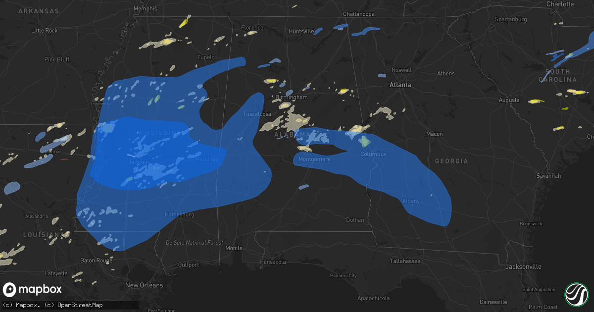
Hail Map in Alabama on May 4, 2021
Get this storm
May 4 map
$229
one time, instant access
Download today. No call, no setup
Keep the $229
Bought the map and want the full workflow? Apply the entire $229 to a subscription within 7 days. None of it is wasted.
Every map, not just this one
This buys you this map. Subscription and you get every map we run, in the markets you choose from a few cities to whole states to nationwide. Plus real-time alerts the moment a storm fires.
Contact data
Name, contact info, occupancy, even credit band for addresses in the footprint. You go from where it hit to who to call.
Become the source they trust
Unlimited branding weather history reports on demand. You already have the documented answer ready for the property owner, and you are the one who showed up with it.
Property data and RoofTrace estimates
Pull up any address you have got, its value and the exact code rules for that jurisdiction, straight from One Click Code. Then RoofTrace estimates the squares, pitch, and roof value, priced the way you price.
Storm reports in Alabama
Alabama
| Date | Description |
|---|---|
| 05/04/20216:57 PM CDT | Corrects previous tstm wnd dmg report from tuskegee for time. Trees blown down at various locations across macon county. |
| 05/04/20216:50 PM CDT | Tree on a home on hwy 49 s. 1 minor injury. |
| 05/04/20216:50 PM CDT | Power out... Trees down and fencing blown over in rolling hills area in pike road. |
| 05/04/20216:48 PM CDT | Trees down blocking alabama hwy 168. |
| 05/04/20216:46 PM CDT | Timber damage was surveyed near chubahatchee creek along crosskeys road in macon county and determined to be consistent with a brief ef-0 tornado. Most of the path was |
| 05/04/20216:45 PM CDT | Trees and power lines down in greenville on highway 10 near stabler hospital. |
| 05/04/20216:45 PM CDT | Multiple roads with trees down across the city of greenville. West commerce st near the hospital is closed due to downed trees and partially closed on hwy 31s near high |
| 05/04/20216:45 PM CDT | Trees blown down at various locations across the county. Some structures were heavily damaged by fallen trees... With at least 30 instances of roads blocked by fallen t |
| 05/04/20216:42 PM CDT | Tree down on hwy 79. |
| 05/04/20216:42 PM CDT | Numerous trees and powerlines down in alexander city. |
| 05/04/20216:35 PM CDT | 58 mph measured gust. |
| 05/04/20216:34 PM CDT | Trees down at various locations across the county. Some trees fell onto structures. |
| 05/04/20216:30 PM CDT | Trees uprooted on a home with two people trapped. |
| 05/04/20216:26 PM CDT | Mesonet station in grove hill gusted to 67 mph. |
| 05/04/20216:23 PM CDT | Trees down county-wide... Including in coosada and redland. |
| 05/04/20216:21 PM CDT | Trees blown down at various locations across lowndes county. |
| 05/04/20216:18 PM CDT | Numerous trees uprooted on rocky mount road. |
| 05/04/20216:17 PM CDT | Wind damage was prevalent along a line of storms that moved through autauga and elmore counties... Making it hard to distinguish between straight-line wind damage and t |
| 05/04/20216:15 PM CDT | Trees down. |
| 05/04/20216:15 PM CDT | Trees down. |
| 05/04/20216:15 PM CDT | Trees down. |
| 05/04/20216:12 PM CDT | Tree down near intersection of rockville rd and suel rd. |
| 05/04/20216:11 PM CDT | Trees blown down at various locations across coosa county. |
| 05/04/20216:10 PM CDT | Trees down in beatrice. |
| 05/04/20216:05 PM CDT | Multiple trees down on i-65 southbound at mile marker 197. |
| 05/04/20216:05 PM CDT | Large tree down near intersection of gainestown rd & rockville rd. |
| 05/04/20216:00 PM CDT | Approximately 20 trees snapped in town. Minor damage to a mobile home. Time estimated from radar. |
| 05/04/20216:00 PM CDT | Tree fell on a home off of beech grove rd. |
| 05/04/20215:58 PM CDT | Law enforcement reports tree down in leroy on cr 34. |
| 05/04/20215:57 PM CDT | Trees blown down at various locations across macon county. |
| 05/04/20215:55 PM CDT | Large tree fell on the union united methodist church and damaging the building... And lifted it off of its foundation. |
| 05/04/20215:50 PM CDT | Trees blown down at various locations across chilton county. |
| 05/04/20215:50 PM CDT | Multiple trees down along ellis island rd. Reports and pictures via social media. |
| 05/04/20215:50 PM CDT | Corrected time. Mesonet station in grove hill gusted to 67 mph. |
| 05/04/20215:50 PM CDT | Large tree down. Part of a roof blown off a shed. Report via social media. |
| 05/04/20215:45 PM CDT | Trees blown down at various locations across dallas county. A business in selma had its roof peeled off. |
| 05/04/20215:40 PM CDT | Trees and power lines down near wilson hall middle school. |
| 05/04/20215:38 PM CDT | Multiple trees and power lines downed. Associated with tds on radar. Likely tornado. |
| 05/04/20215:38 PM CDT | Report from mping: 1-inch tree limbs broken; shingles blown off. |
| 05/04/20215:38 PM CDT | Tree down along west cobb rd blocking roadway. |
| 05/04/20215:35 PM CDT | Trees blown down at various locations in southwest chilton county. |
| 05/04/20215:32 PM CDT | Chatom police reported large tree down in yarbo community on france city rd. |
| 05/04/20215:31 PM CDT | Report from mping: 1-inch tree limbs broken; shingles blown off. |
| 05/04/20215:25 PM CDT | Corrects previous tstm wnd dmg report from 3 nnw decatur. Social media photo of a 60 year old oak tree uprooted in decatur. Time estimated by radar. Time estimated by r |
| 05/04/20215:25 PM CDT | A tree was down at banks-caddell elementary school. Time estimated by radar. |
| 05/04/20215:25 PM CDT | Tree down near the corner of 7th ave. Se and 5th st. Se. |
| 05/04/20215:25 PM CDT | Trees down in the thomasville area. |
| 05/04/20215:20 PM CDT | Trees and power lines down along bashi rd. |
| 05/04/20215:19 PM CDT | An ef-0 tornado track was confirmed by nws bmx survey team from northeast perry county to southwest chilton county. The tornado began along j mitchell road and moved ea |
| 05/04/20215:18 PM CDT | Trees down blocking the road near coffeeville. |
| 05/04/20215:17 PM CDT | Trees blown down at various locations across perry county. Some roof damage in areas as well. |
| 05/04/20215:10 PM CDT | Trees down along highway 69 near campbells landing rd |
| 05/04/20215:03 PM CDT | Helena road flooded with water flowing over the road near the quarry. |
| 05/04/20215:02 PM CDT | Trees down on cr 208. |
| 05/04/20215:02 PM CDT | Trees down on cr 43. |
| 05/04/20215:01 PM CDT | Damage to a home on hwy 69... South of greensboro. Many trees snapped at same location. |
| 05/04/20215:01 PM CDT | Widespread trees downed and power lines downed along highway 14 in hale county. |
| 05/04/20215:00 PM CDT | Trees down along cr14. |
| 05/04/20214:57 PM CDT | Large trees snapped. |
| 05/04/20214:56 PM CDT | Trees down on home on south strawberry st. Via social media. |
| 05/04/20214:50 PM CDT | Multiple trees and power lines down across choctaw county. |
| 05/04/20214:46 PM CDT | Trees down. Reported on social media. |
| 05/04/20214:33 PM CDT | Tree down on queen city ave near 15th street. |
| 05/04/20214:30 PM CDT | Trees blown down at various locations in sumter county. Power lines downed as well. |
| 05/04/20214:26 PM CDT | Several trees uprooted along hoggle ridge road. |
| 05/04/20214:25 PM CDT | Tree down on hagler road. |
| 05/04/20214:20 PM CDT | Tree down on county road 11. |
| 05/04/20214:20 PM CDT | Tree down on us highway 43. |
| 05/04/20214:20 PM CDT | Trees down along i-20 between york and cuba. |
| 05/04/20214:16 PM CDT | Multiple trees down. Reported by fire official. |
| 05/04/20214:15 PM CDT | Report from mping: quarter |
| 05/04/20211:31 PM CDT | Hail dollar or slightly larger hail reported on social media. |
| 05/04/20211:09 PM CDT | Flooding on cobb street. |
| 05/04/202112:28 PM CDT | Trees down along sunrise and south hillcrest roads. |
| 05/04/202112:28 PM CDT | Trees down. Reported by spotter. |
| 05/04/202112:15 PM CDT | Trees and power lines down. |
| 05/04/202112:05 PM CDT | Tree down across county road 30. |
| 05/04/202112:03 PM CDT | Trees uprooted. Reported by trained spotter. |
| 05/04/202112:00 PM CDT | Trees down on toadvine road and camp oliver road. |
| 05/04/202111:26 AM CDT | Tree down along state highway 160 in hayden. |
| 05/04/202111:11 AM CDT | A local report indicates 1.00 inch wind near JASPER |
| 05/04/202110:58 AM CDT | Power lines down along duck springs road. |
| 05/04/202110:50 AM CDT | Trees down along buster willet road and sand valley road. |
| 05/04/202110:46 AM CDT | Trees down and blocking the roadway at hwy 179 and barnes road. |
| 05/04/202110:18 AM CDT | Tree down across 4th street. |
| 05/04/202110:14 AM CDT | Trees and powerlines down blocking roadway. |
| 05/04/202110:12 AM CDT | Tree down across bridge at philadelphia road and center springs road in trafford. |
| 05/04/20219:44 AM CDT | Social media report of a tree knocked down in flat rock. |
| 05/04/20219:43 AM CDT | A tree was uprooted damaging a fence and shed. Social media report through broadcast media. Time estimated by radar. |
| 05/04/20219:41 AM CDT | A tree was knocked down on cr 318. Time estimated by radar. |
| 05/04/20219:40 AM CDT | Correction: trees down across hwy 79 at cr21 south of skyline. Trees also down at intersection of cr107 and cr241 near hytop. |
| 05/04/20219:33 AM CDT | Tree down near county road 5 and hayes road. |
| 05/04/20219:10 AM CDT | Trees and power lines were knocked down at cr 107 at cr 241. Time estimated by radar. |
| 05/04/20219:08 AM CDT | Corrects previous tstm wnd dmg report from 3 s skyline. Correction: trees down across hwy 79 at cr21 south of skyline. |
| 05/04/20219:07 AM CDT | A tree was knocked down. Time estimated by radar. |
| 05/04/20218:57 AM CDT | Social media photo of a 60 year old oak tree uprooted in decatur. Time estimated by radar. |
| 05/04/20218:56 AM CDT | Tree down on sparkman road near first baptist church in hartselle. |
| 05/04/20218:50 AM CDT | Emergency manager reported 7 to 8 trees down from sw marshall to ne marshall county. |
| 05/04/20218:50 AM CDT | Measured at the huntsville international airport. |
| 05/04/20218:10 AM CDT | Up to 5 power poles were broken and trees knocked down at 2045 cr 222. |
| 05/04/20218:00 AM CDT | A tree was knocked down at the intersection of cr 291 and cr 292. |
| 05/04/20217:58 AM CDT | A tree was knocked down at cr 222. |
| 05/04/20217:56 AM CDT | At 1255 PM CDT, severe thunderstorms were located along a line extending from 6 miles southwest of Ball Flat to Pell City, moving east at 45 mph. HAZARD...60 mph wind gusts and quarter size hail. SOURCE...Radar indicated. IMPACT...Hail damage to vehicles is expected. Expect wind damage to roofs, siding, and trees. Locations impacted include... Anniston, Oxford, Jacksonville, Piedmont, Heflin, West End-Cobb Town, Cobb Town, Fort McClellan, Saks, Lincoln, Weaver, Munford, Hobson City, Ranburne, Fruithurst, Edwardsville, Talladega Superspeedway, Pleasant Gap, Alexandria and Talladega Municipal Airport. |
| 05/04/20217:17 AM CDT | At 1217 PM CDT, severe thunderstorms were located along a line extending from Odenville to Mountain Brook, moving east at 10 mph. HAZARD...60 mph wind gusts. SOURCE...Radar indicated. IMPACT...Expect damage to roofs, siding, and trees. Locations impacted include... Vestavia Hills, Trussville, Irondale, Leeds, Moody, Springville, Odenville, Margaret, Argo, Vincent, Harpersville, Shops of Grand River, Bald Rock, Vandiver, Barber Motorsports Park, Branchville, Lake Purdy, Grants Mill Road Bridge, St. Clair Springs and Sterrett. |
| 05/04/20217:14 AM CDT | At 1214 PM CDT, severe thunderstorms were located along a line extending from near Altoona to Leeds, moving east at 45 mph. HAZARD...60 mph wind gusts. SOURCE...Radar indicated. IMPACT...Expect damage to roofs, siding, and trees. Locations impacted include... Anniston, Oxford, Pell City, Rainbow City, Cobb Town, West End-Cobb Town, Saks, Lincoln, Glencoe, Weaver, Ashville, Riverside, Ragland, Munford, Ohatchee, Steele, Hobson City, Talladega Superspeedway, Anniston Regional Airport and Blue Mountain. |
| 05/04/20217:10 AM CDT | 4/5 broken power poles and trees down at this location. |
| 05/04/20217:04 AM CDT | Tree down at the intersection of cr 291 and 292. |
| 05/04/20216:49 AM CDT | At 1148 AM CDT, severe thunderstorms were located along a line extending from Locust Fork to near Forestdale, moving east at 60 mph. HAZARD...60 mph wind gusts and quarter size hail. SOURCE...Radar indicated. IMPACT...Hail damage to vehicles is expected. Expect wind damage to roofs, siding, and trees. Locations impacted include... Northern Birmingham, Trussville, Gardendale, Irondale, Leeds, Moody, Fultondale, Oneonta, Springville, Odenville, Cleveland, Dallas, Center Point, Clay, Pinson, Tarrant, Margaret, Argo, Warrior and Kimberly. |
| 05/04/20216:25 AM CDT | At 1124 AM CDT, severe thunderstorms were located along a line extending from near Smith Dam to near Gorgas, moving east at 20 mph. HAZARD...60 mph wind gusts and quarter size hail. SOURCE...Radar indicated. IMPACT...Hail damage to vehicles is expected. Expect wind damage to roofs, siding, and trees. Locations impacted include... Jasper, Sumiton, Cordova, Dora, Adamsville, Graysville, Brookside, Parrish, Sipsey, Maytown, West Jefferson, Cardiff, Curry, Gorgas Steam Plant, Smith Dam, Gorgas, Rocky Hollow, Burnwell, Beloit and Quinton. |
| 05/04/20216:18 AM CDT | At 1118 AM CDT, a severe thunderstorm was located over Sipsey, or near Sumiton, moving east at 45 mph. HAZARD...60 mph wind gusts and quarter size hail. SOURCE...Radar indicated. IMPACT...Hail damage to vehicles is expected. Expect wind damage to roofs, siding, and trees. Locations impacted include... Garden City, Colony, Arkadelphia and Black Bottom. |
| 05/04/20215:26 AM CDT | At 1026 AM CDT, a severe thunderstorm was located near Nectar, or 7 miles west of Cleveland, moving east at 55 mph. HAZARD...60 mph wind gusts. SOURCE...Radar indicated. IMPACT...Expect damage to roofs, siding, and trees. Locations impacted include... Oneonta, Blountsville, Cleveland, Altoona, Snead, Susan Moore, Walnut Grove, Allgood, Fairview, Nectar, Rosa, McLarty, Bangor, Brooksville, Easley, Chamblees Mill, Fowler Spring and Hendrix. |
| 05/04/20214:39 AM CDT | At 939 AM CDT, severe thunderstorms were located along a line extending from near Bridgeport to 7 miles southeast of Stevenson to near Henagar, moving northeast at 35 mph. HAZARD...60 mph wind gusts and penny size hail. SOURCE...Radar indicated. IMPACT...Expect damage to roofs, siding, and trees. Locations impacted include... Bridgeport, Henagar, Ider, Rosalie, Long Island, Russell Cave National Monument and Higdon. |
| 05/04/20214:31 AM CDT | At 930 AM CDT, a severe thunderstorm was located over Addison, or 9 miles north of Arley, moving east at 45 mph. HAZARD...60 mph wind gusts and penny size hail. SOURCE...Radar indicated. IMPACT...Expect damage to roofs, siding, and trees. Locations impacted include... Cullman, Hartselle, Good Hope, Falkville, Holly Pond, Morgan City, Baldwin, Vinemont, Baileyton and West Point. |
| 05/04/20214:07 AM CDT | At 906 AM CDT, a severe thunderstorm was located near Ashbank, or near Lynn, moving northeast at 55 mph. HAZARD...60 mph wind gusts. SOURCE...Radar indicated. IMPACT...Expect damage to roofs, siding, and trees. Locations impacted include... Lynn, Arley, Double Springs, Addison, Nauvoo, Houston Recreational Area, Camp McDowell, Nesmith, Ashbank, Brushy Lake, Poplar Springs, Ashridge, Falls City, Moreland, Smith Lake, Helicon, Inmanfield, Sardis, Corinth Rec Area and Winston Free State Barn. |
| 05/04/20213:25 AM CDT | At 825 PM EDT, severe thunderstorms were located along a line extending from near Denson to near Beans Mill to Marvyn to near Warriorstand, moving east at 65 mph. HAZARD...70 mph wind gusts and quarter size hail. SOURCE...Radar indicated. IMPACT...Hail damage to vehicles is expected. Expect considerable tree damage. Wind damage is also likely to mobile homes, roofs, and outbuildings. Locations impacted include... LaGrange, Hamilton, Talbotton, Greenville, Cusseta, Manchester, West Point, Pine Mountain, Woodbury, Waverly Hall, Warm Springs, Woodland, Geneva, Gay, Fort Benning/lawson Army Air Fld, North Fort Benning, Bibb City, Upatoi, F.d. Roosevelt State Park and Green Island Hills. |
| 05/04/20212:51 AM CDT | At 751 PM EDT, a severe thunderstorm was located over State Line Park, or 8 miles east of Stroud, moving northeast at 55 mph. HAZARD...60 mph wind gusts and quarter size hail. SOURCE...Radar indicated. IMPACT...Hail damage to vehicles is expected. Expect wind damage to roofs, siding, and trees. Locations impacted include... Columbus, LaGrange, Hamilton, Greenville, Manchester, West Point, Hogansville, Pine Mountain, Waverly Hall, Warm Springs, Lone Oak, North Fort Benning, Bibb City, Upatoi, F.d. Roosevelt State Park, Green Island Hills, Cataula, Columbus Metropolitan Airport, Louise and Stovall. |
| 05/04/20212:44 AM CDT | At 743 PM CDT, severe thunderstorms were located along a line extending from 3 miles southeast of Goshen to 5 miles north of Opp to 12 miles northwest of Laurel Hill, moving east at 35 mph. HAZARD...60 mph wind gusts. SOURCE...Radar indicated. IMPACT...Expect damage to roofs, siding, and trees. Locations impacted include... Andalusia, Opp, River Falls and Heath. |
| 05/04/20211:37 AM CDT | At 636 PM CDT, severe thunderstorms were located along a line extending from near Southern Lake Martin to Greenville, moving east at 40 mph. HAZARD...60 mph wind gusts. A wind gust to 58 mph was recently recorded at the Montgomery airport. Wind damage has also been reported with this line of storms. SOURCE...Radar indicated. IMPACT...Expect damage to roofs, siding, and trees. Locations impacted include... Troy, Tuskegee, Union Springs, Brundidge, Notasulga, Midway, Goshen, Milstead, Shorter, Banks, Franklin, Pickett, Lake Tuskegee, Beans Crossroads, Guerryton, Shopton, Tuskegee National Forest, Liverpool, Liberty City and Hardaway. |
| 05/04/20211:28 AM CDT | At 628 PM CDT, severe thunderstorms were located along a line extending from 4 miles southwest of Gordonville to 4 miles east of Pine Apple to 6 miles east of Beatrice to Peterman, moving east at 45 mph. HAZARD...60 mph wind gusts. SOURCE...Radar indicated. IMPACT...Expect damage to roofs, siding, and trees. Locations impacted include... Greenville, Monroeville, Luverne, Peterman, Georgiana, Brantley, McKenzie, Red Level, Rutledge, Beatrice, Dozier, Gantt, Glenwood, Pine Apple, Petrey and Highland Home. |
| 05/04/20211:19 AM CDT | At 618 PM CDT, severe thunderstorms were located along a line extending from near Parkdale to near Maxwell Air Force Base, moving east at 50 mph. HAZARD...60 mph wind gusts. This line of storms has a history of producing wind damage. SOURCE...Radar indicated. IMPACT...Expect damage to roofs, siding, and trees. Locations impacted include... Alexander City, Tallassee, Dadeville, Camp Hill, Jacksons' Gap, New Site, Goldville, Martin Dam, Reeves Airport, Southern Lake Martin, Hillabee Creek, Eastern Lake Martin, Liberty City, Tallapoosa City, Northern Lake Martin, Wind Creek State Park, Still Waters Resort, Western Lake Martin, Daviston and Hackneyville. |
| 05/04/20211:07 AM CDT | At 607 PM CDT, severe thunderstorms were located along a line extending from Booth to 11 miles northeast of Pine Apple, moving east at 50 mph. HAZARD...60 mph wind gusts. SOURCE...Radar indicated. IMPACT...Expect damage to roofs, siding, and trees. Locations impacted include... Montgomery, Meadville, Pike Road, Coosada, Pine Level, Montgomery Zoo, Boylston, Hyundai Motors Of Alabama, Auburn University In Montgomery, Dublin, Bob Woodruff Lake, Woodcrest, Maxwell Air Force Base, Snowdoun, Grady, Sellers, Davenport, Ramer, Waugh and Lagoon Park. |
| 05/04/202112:59 AM CDT | At 559 PM CDT, severe thunderstorms were located along a line extending from near Marbury to near Autaugaville, moving east at 50 mph. HAZARD...60 mph wind gusts. SOURCE...Radar indicated. IMPACT...Expect damage to roofs, siding, and trees. Locations impacted include... Prattville, Millbrook, Wetumpka, Tallassee, Elmore, Coosada, Deatsville, Eclectic, Santuck, Titus, Emerald Mountain, Ten Cedar Estates, Dexter, Weoka Mills, Jordan Lake, Blue Ridge, Kowaliga Bridge, Welona, Martin Dam and Western Lake Martin. |
| 05/04/202112:54 AM CDT | At 554 PM CDT, severe thunderstorms were located along a line extending from near Lay Lake to near Pooles Crossroads, moving east at 55 mph. HAZARD...60 mph wind gusts. SOURCE...Radar indicated. IMPACT...Expect damage to roofs, siding, and trees. Locations impacted include... Goodwater, Rockford, Kellyton, Weogufka, Equality, Stewartville, Hanover, Lyle, Pentonville, Dollar, Bradford, Cottage Grove, Strickland Crossroads, Bentleyville, Marble Valley, Moriah, Hatchet, Nixburg, Speed and Highway 9 and Highway 22. |
| 05/04/202112:33 AM CDT | At 532 PM CDT, severe thunderstorms were located along a line extending from 3 miles southeast of Consul to 3 miles southeast of Thomasville to 8 miles northwest of Grove Hill to 4 miles southwest of Coffeeville, moving east at 55 mph. HAZARD...60 mph wind gusts. SOURCE...Radar indicated. IMPACT...Expect damage to roofs, siding, and trees. Locations impacted include... Greenville, Thomasville, Camden, Grove Hill, Peterman, Georgiana, Whatley, Pine Hill, Beatrice, Vredenburgh, Fulton, Yellow Bluff and Pine Apple. |
| 05/04/202112:29 AM CDT | At 528 PM CDT, severe thunderstorms were located along a line extending from Brierfield Ironworks Park to 6 miles west of Dannelly Reservoir, moving east at 60 mph. HAZARD...60 mph wind gusts. This line of storms has a history of producing wind damage. SOURCE...Radar indicated. IMPACT...Expect damage to roofs, siding, and trees. Locations impacted include... Prattville, Millbrook, Calera, Clanton, Jemison, Fort Deposit, Mosses, Hayneville, Thorsby, Deatsville, Autaugaville, White Hall, Maplesville, Gordonville, Billingsley, Lowndesboro, Benton, Gap Of The Mountain, Autauga County Airport and Verbena. |
| 05/04/202112:00 AM CDT | At 500 PM CDT, severe thunderstorms were located along a line extending from near Low Gap to near Dixons Mill, moving east at 55 mph. HAZARD...60 mph wind gusts. Wind damage has been reported with this line of storms. SOURCE...Radar indicated. IMPACT...Expect damage to roofs, siding, and trees. Locations impacted include... Selma, Brent, Valley Grande, Marion, Centreville, Uniontown, Selmont-West Selmont, Maplesville, Orrville, Newbern, Bogue Chitto, Vaiden, Parnell, Tyler, Dannelly Reservoir, Paul M Grist State Park, Low Gap, Mertz, Dallas Lake and Talladega National Forest. |
| 05/03/202111:59 PM CDT | At 458 PM CDT, severe thunderstorms were located along a line extending from 4 miles south of Pennington to near Toxey to 5 miles northeast of Waynesboro to 8 miles southeast of Mill Creek, moving east at 40 mph. HAZARD...60 mph wind gusts. SOURCE...Radar indicated. IMPACT...Expect damage to roofs, siding, and trees. Locations impacted include... Jackson, Waynesboro, Thomasville, Butler, Grove Hill, Saint Stephens, Leroy, Clara, Pine Hill, Millry, Buckatunna, Silas, Coffeeville, Pennington, Fulton, Gilbertown, Yellow Bluff and Toxey. |
| 05/03/202111:30 PM CDT | At 429 PM CDT, severe thunderstorms were located along a line extending from near West Greene to near Butler, moving east at 50 mph. HAZARD...60 mph wind gusts. Wind damage has been reported with this line of storms. SOURCE...Radar indicated. IMPACT...Expect damage to roofs, siding, and trees. Locations impacted include... Demopolis, Greensboro, Linden, Jefferson, Moundville, Thomaston, Akron, Sweet Water, Newbern, Myrtlewood, Faunsdale, Dayton, Nanafalia, Consul, Magnolia, Sawyerville, Wayne, Miller, Vineland and Arcola. |
| 05/03/202111:20 PM CDT | At 420 PM CDT, a severe thunderstorm was located near Emelle, or 12 miles north of Livingston, moving east at 50 mph. HAZARD...60 mph wind gusts. SOURCE...Radar indicated. IMPACT...Expect damage to roofs, siding, and trees. Locations impacted include... Eutaw, Forkland, Boligee, Union, Gainesville, Epes, New West Greene, Mantua, Allison, Walden Quarters, West Greene, Knoxville, Thornhill, Tishabee, Snoddy, New Mount Hebron, Eutaw Municipal Airport, Clinton, Five Points Intersection and I 20 Rest Area Near Eutaw. |
| 05/03/202111:13 PM CDT | At 413 PM CDT, severe thunderstorms were located along a line extending from near Gordo to near Knoxville, moving east at 40 mph. HAZARD...60 mph wind gusts. SOURCE...Radar indicated. IMPACT...Expect damage to roofs, siding, and trees. Locations impacted include... Tuscaloosa, Northport, Holt, Brookwood, Coaling, Vance, Coker, Samantha, McFarland Mall, Lake Lurleen State Park, Tuscaloosa Amphitheater, Tuscaloosa Regional Airport, Lake Wildwood, Mercedes Benz Of Alabama, Binion Creek Landing, Abernant, Shelton State Community College, Bryant Denny Stadium, University Mall and Deerlick Creek Campgrounds. |
| 05/03/202110:55 PM CDT | At 354 PM CDT, severe thunderstorms were located along a line extending from 4 miles east of Suqualena to 3 miles northwest of Paulding to 5 miles south of Turnerville to near Mount Olive, moving east at 70 mph. HAZARD...70 mph wind gusts. SOURCE...Radar indicated. IMPACT...Expect considerable tree damage. Damage is likely to mobile homes, roofs, and outbuildings. Locations impacted include... Waynesboro, Butler, Chatom, Clara, Lisman, Millry, State Line, Buckatunna, Silas, Coffeeville, Pennington, Gilbertown and Toxey. |
| 05/03/202110:50 PM CDT | At 350 PM CDT, severe thunderstorms were located along a line extending from Meehan to near Taylorsville, moving east at 75 mph. HAZARD...70 mph wind gusts and nickel size hail. SOURCE...Radar indicated. IMPACT...Expect considerable tree damage. Damage is likely to mobile homes, roofs, and outbuildings. Severe thunderstorms will be near... Sable around 400 PM CDT. Snell around 410 PM CDT. Goodwater around 415 PM CDT.Other locations impacted by these severe thunderstorms includePachuta and Shubuta. |
| 05/03/202110:50 PM CDT | At 349 PM CDT, severe thunderstorms were located along a line extending from near Bluff Springs to near Nellieburg, moving east at 60 mph. HAZARD...70 mph wind gusts. SOURCE...Radar indicated. IMPACT...Expect considerable tree damage. Damage is likely to mobile homes, roofs, and outbuildings. Locations impacted include... Livingston, York, Cuba, Gainesville, Epes, Emelle, Panola, The University Of West Alabama, Dug Hill, Boyd, Bluffport, Coatopa, Kinterbish, Geiger, Old Mallard Airport, Belmont, Demopolis Lock And Dam, Sumterville, McDowell and Bellamy. |
| 05/03/202110:49 PM CDT | At 349 PM CDT, severe thunderstorms were located along a line extending from Sessums to Mashulaville, moving east at 55 mph. HAZARD...60 mph wind gusts. SOURCE...Radar indicated. IMPACT...Expect damage to roofs, siding, and trees. Severe thunderstorms will be near... Macon and Bent Oak around 400 PM CDT. Deerbrook around 405 PM CDT. Columbus and Prairie Point around 410 PM CDT. Steens and Bigbee Valley around 415 PM CDT.Other locations impacted by these severe thunderstorms includeShuqualak and Artesia. |
| 05/03/202110:36 PM CDT | At 336 PM CDT, a severe thunderstorm was located near Decatur, or 10 miles northeast of Newton, moving east at 70 mph. HAZARD...60 mph wind gusts and quarter size hail. SOURCE...Radar indicated. IMPACT...Hail damage to vehicles is expected. Expect wind damage to roofs, siding, and trees. This severe thunderstorm will be near... Suqualena and Meehan around 345 PM CDT. Meridian and Nellieburg around 350 PM CDT. Marion and Zero around 355 PM CDT. Toomsuba around 400 PM CDT. Kewanee and Alamucha around 405 PM CDT. |
| 05/03/202110:33 PM CDT | At 332 PM CDT, a severe thunderstorm was located over Okolona, moving east at 40 mph. HAZARD...60 mph wind gusts. SOURCE...Radar indicated. IMPACT...Expect damage to roofs, siding, and trees. Locations impacted include... Amory, Aberdeen, Okolona, Shannon, Smithville, Prairie, New Salem, New Wren, Trebloc, Nettleton, Hatley, Gattman, Quincy, Turon, Egypt, Wise Gap, Wren, McCondy, Leotis and Buena Vista. |
| 05/03/202110:17 PM CDT | At 317 PM CDT, a severe thunderstorm was located near Mantachie, or near Fulton, moving east at 45 mph. HAZARD...60 mph wind gusts. SOURCE...Radar indicated. IMPACT...Expect damage to roofs, siding, and trees. Locations impacted include... Fulton, Mantachie, Tremont, Fairview, New Salem, Evergreen, Clay, Abney, Eastman, Cardsville, Tilden, Mooreville, Eggville, Ballardsville, Bounds Crossroads, Dorsey, Jacinto, Cadamy and Richmond. |
| 05/03/20218:55 PM CDT | Trees down. |
| 05/03/20218:55 PM CDT | Trees down. |
| 05/03/20218:52 PM CDT | Tree down on cr 1 in abbeville. |
| 05/03/20218:45 PM CDT | Tree down. |
| 05/03/20218:40 PM CDT | Corrects previous tstm wnd dmg report from abbeville. Tree down on cr 1 in abbeville. |
| 05/03/20218:30 PM CDT | Powerlines down. |
| 05/03/20218:30 PM CDT | Powerline down on stuart tarter rd in dale county. |
| 05/03/20218:20 PM CDT | Trees down. |
| 05/03/20218:15 PM CDT | At 115 PM CDT, a severe thunderstorm was located near Hoover Metropolitan Stadium, or near Bessemer, moving east at 30 mph. HAZARD...60 mph wind gusts and quarter size hail. SOURCE...Radar indicated. IMPACT...Hail damage to vehicles is expected. Expect wind damage to roofs, siding, and trees. Locations impacted include... Southwestern Birmingham, Hoover, Vestavia Hills, Bessemer, Homewood, Pelham, Mountain Brook, Helena, Chelsea, Brighton, Indian Springs Village, Lipscomb, Oak Mountain State Park, Bluff Park, Oak Mountain Amphitheater, Samford University, Cahaba Heights, Riverchase, Patton Creek and Hoover Metropolitan Stadium. |
| 05/03/20218:02 PM CDT | Powerlines down on s eufaula ave and dale rd in eufaula. |
| 05/03/20217:51 PM CDT | Large tree down on hwy 165 between corcoran rd and the eufaula wildlife preserve. |
| 05/03/20217:51 PM CDT | Large tree fallen on road on elba hwy at powell rd. |
| 05/03/20217:50 PM CDT | Fallen tree at mile marker 32 on hwy 189. |
| 05/03/20217:47 PM CDT | Trees and powerlines down in roadway. Cr 304 and cr 308 in coffee county... Al. |
| 05/03/20217:32 PM CDT | Trees blown down at various locations across russell county. |
| 05/03/20217:30 PM CDT | Fallen tree near intersection of glenwood rd and new hope church rd. |
| 05/03/20217:30 PM CDT | Several trees and power lines down in the rose hill community. |
| 05/03/20217:30 PM CDT | Trees blown down at various locations across chambers county... But especially in the lanett and valley areas. |
| 05/03/20217:25 PM CDT | Fallen power lines on roy beall dr in luverne. |
| 05/03/20217:25 PM CDT | An additional report of at least 75 trees snapped across gantt community via social media. |
| 05/03/20217:22 PM CDT | Trees down on cr 2201 and cr 2219... Near goshen. |
| 05/03/20217:20 PM CDT | At least 15-20 trees down and structural damage to a barn and a mobile home in the gantt community. Reports and photos via social media. |
| 05/03/20217:17 PM CDT | Trees down near rawls school rd at boston rd. |
| 05/03/20217:16 PM CDT | Tree down on asbury rd. |
| 05/03/20217:14 PM CDT | Trees blown down at various locations in the opelika area. Power lines also downed. |
| 05/03/20217:13 PM CDT | Trees blown down at various locations in the beauregard area. |
| 05/03/20217:10 PM CDT | Trees blown down at various locations across bullock county... Blocking some roadways. |
| 05/03/20217:06 PM CDT | Trees blown down at various locations across the auburn area. |
| 05/03/20217:03 PM CDT | Tree down on a home at conway acres on wire rd. |
All States Impacted by Hail Map on May 4, 2021
Cities Impacted by Hail Map on May 4, 2021
- Saulsbury, TN
- Walnut, MS
- Ashland, MS
- Michigan City, MS
- Morton, MS
- Pelahatchie, MS
- Sulphur, LA
- French Settlement, LA
- Maurepas, LA
- Saint Amant, LA
- Clanton, AL
- Verbena, AL
- Billingsley, AL
- Martindale, TX
- Milam, WV
- Bergton, VA
- Moorefield, WV
- Waterford, MS
- Como, MS
- Holly Springs, MS
- Abbeville, MS
- Ruleville, MS
- Doddsville, MS
- Cleveland, MS
- Valley, AL
- Opelika, AL
- Hamilton, GA
- Cusseta, AL
- West Point, GA
- Salem, AL
- Smithville, TX
- Palacios, TX
- Florence, MS
- Frierson, LA
- Stonewall, LA
- Quicksburg, VA
- New Market, VA
- Timberville, VA
- Mount Jackson, VA
- Weogufka, AL
- Equality, AL
- Eclectic, AL
- Rockford, AL
- Alexander City, AL
- Elmore, AL
- Titus, AL
- Prattville, AL
- Deatsville, AL
- Wetumpka, AL
- Millbrook, AL
- Marbury, AL
- Ashburn, GA
- Pheba, MS
- Maben, MS
- Lamar, MS
- Bastrop, TX
- Red Rock, TX
- Cedar Creek, TX
- Florien, LA
- Steeles Tavern, VA
- Greenville, VA
- Raphine, VA
- Heflin, AL
- Anniston, AL
- Sardis, MS
- Crenshaw, MS
- Wilsonville, AL
- Columbiana, AL
- Gary, TX
- Tenaha, TX
- Timpson, TX
- Cameron, SC
- Effie, LA
- Jonesville, LA
- Marksville, LA
- Pennington, TX
- Groveton, TX
- Apple Springs, TX
- Kennard, TX
- Nacogdoches, TX
- Lafayette, AL
- Camp Hill, AL
- Five Points, AL
- Lanett, AL
- Moorhead, MS
- Indianola, MS
- Bienville, LA
- Crosby, MS
- Brent, AL
- Williston, SC
- Bedford, VA
- Big Island, VA
- Rolling Fork, MS
- Glen Allan, MS
- Hollandale, MS
- Mayersville, MS
- Anguilla, MS
- Lumberton, TX
- Kountze, TX
- Lockhart, TX
- Caldwell, TX
- Jasper, AL
- Vesuvius, VA
- Tyro, VA
- Montebello, VA
- Draper, VA
- Hamburg, AR
- Ragley, LA
- Starks, LA
- Lake Charles, LA
- Longville, LA
- Mittie, LA
- Dequincy, LA
- Oakdale, LA
- Kinder, LA
- Singer, LA
- Oberlin, LA
- Dry Creek, LA
- Iowa, LA
- Reeves, LA
- Warrior, AL
- Dora, AL
- Empire, AL
- Brenham, TX
- Ruffin, SC
- Islandton, SC
- Lovelady, TX
- Trinity, TX
- Amite, LA
- Holden, LA
- Walker, LA
- Dale, TX
- Dermott, AR
- Goode, VA
- Fulks Run, VA
- Broadway, VA
- Mathias, WV
- Criders, VA
- Middlebrook, VA
- Kyle, TX
- Philadelphia, MS
- Carthage, MS
- Jemison, AL
- Luray, VA
- Gloster, MS
- Centreville, MS
- Baytown, TX
- Brandywine, WV
- Franklin, WV
- Greenville, MS
- Windsor, SC
- Blackville, SC
- Parrish, AL
- Cordova, AL
- Montrose, AR
- Crossett, AR
- Woodville, MS
- Batchelor, LA
- Bessemer, AL
- Birmingham, AL
- McCalla, AL
- Huntington, TX
- Dayton, TX
- Amissville, VA
- Sperryville, VA
- Flint Hill, VA
- Washington, VA
- Woodville, VA
- Castleton, VA
- Saltillo, MS
- Jackson, MS
- Crystal Springs, MS
- Giddings, TX
- La Grange, TX
- Summerton, SC
- Pinewood, SC
- Gibsland, LA
- Lufkin, TX
- Greensburg, LA
- Orangeburg, SC
- Pleasant Shade, TN
- Haughton, LA
- Elm Grove, LA
- Lake, MS
- Browns Summit, NC
- Greensboro, NC
- Summerfield, NC
- Canton, MS
- Brandon, MS
- Hiwassee, VA
- Roxie, MS
- Meadville, MS
- Pulaski, MS
- Forest, MS
- Raleigh, MS
- Fairfield, VA
- Buena Vista, VA
- Lexington, VA
- Ledbetter, TX
- Huffman, TX
- Lexington, TX
- Rockdale, TX
- Lagrange, GA
- Camden, SC
- Jamestown, LA
- Castor, LA
- Cary, MS
- Burton, TX
- Calera, AL
- Shelby, AL
- Potts Camp, MS
- Oxford, MS
- Shreveport, LA
- McDade, TX
- Elgin, TX
- Carmine, TX
- Satartia, MS
- Sylacauga, AL
- Vidalia, LA
- Ackerman, MS
- Eupora, MS
- Mathiston, MS
- Crosby, TX
- Hickory Flat, MS
- Myrtle, MS
- Madison, MS
- Ridgeland, MS
- Clinton, MS
- Camden, MS
- Woodbury, TN
- Summit, MS
- Smithdale, MS
- Simmesport, LA
- Lettsworth, LA
- Jacksonville, AL
- Eagle Rock, VA
- Clifton Forge, VA
- Booneville, MS
- Georgetown, MS
- Harrisville, MS
- Huger, SC
- Cordesville, SC
- Moncks Corner, SC
- Taylorsville, MS
- Eros, LA
- West Monroe, LA
- Hornbeck, LA
- Woodbridge, VA
- Keithville, LA
- Marietta, MS
- Bastrop, LA
- Saint Matthews, SC
- Jamaica, VA
- Lancaster, VA
- Little Plymouth, VA
- Church View, VA
- Urbanna, VA
- Water View, VA
- Bentonia, MS
- Vaughan, MS
- McCarley, MS
- Winona, MS
- Coila, MS
- Elloree, SC
- Collinston, LA
- Mer Rouge, LA
- Tallulah, LA
- Watson, AR
- Vidor, TX
- Hazlehurst, MS
- Kingsbury, TX
- San Marcos, TX
- Noxapater, MS
- New Albany, MS
- South Mills, NC
- Mendenhall, MS
- Magee, MS
- Cheneyville, LA
- Denham Springs, LA
- Murfreesboro, TN
- Mount Olive, MS
- Mize, MS
- Bryan, TX
- Cherokee, AL
- Benton, MS
- Waverly, AL
- Dunnsville, VA
- Baldwyn, MS
- Saint Martinville, LA
- Round Top, TX
- Brooks, GA
- Senoia, GA
- Rayville, LA
- Gay, GA
- Luthersville, GA
- Greenville, GA
- Catherine, AL
- Camden, AL
- Edinburg, VA
- Orkney Springs, VA
- Amherst, VA
- Poplar Branch, NC
- Grandy, NC
- Collinsville, MS
- Rockbridge Baths, VA
- Tuscumbia, AL
- Liberty, TN
- Dowelltown, TN
- Smithville, TN
- Union, MS
- Decatur, MS
- Sunbury, NC
- Corapeake, NC
- Little Rock, MS
- Chunky, MS
- Hickory, MS
- Meridian, MS
- Newton, MS
- New Braunfels, TX
- Centreville, AL
- Banner, MS
- Water Valley, MS
- Somerville, TX
- Columbia, NC
- Navasota, TX
- Marion, LA
- Braxton, MS
- Pearl, MS
- Terry, MS
- Byram, MS
- Richland, MS
- Louin, MS
- Starkville, MS
- Suffolk, VA
- Farmerville, LA
- Hogansville, GA
- Franklin, GA
- Coffeeville, MS
- Itta Bena, MS
- Greenwood, MS
- Schlater, MS
- Bay Springs, MS
- De Kalb, MS
- Eutaw, AL
- Maxwell, TX
- Seguin, TX
- Bruce, MS
- Sunflower, MS
- Manning, SC
- Sharpsburg, GA
- Grantville, GA
- Moreland, GA
- Newnan, GA
- Warrenton, VA
- Catlett, VA
- Epps, LA
- Dadeville, AL
- Bunkie, LA
- Paige, TX
- Delta, AL
- Leesville, LA
- Bryans Road, MD
- Inverness, MS
- Tappahannock, VA
- Champlain, VA
- Ralph, AL
- Gore Springs, MS
- Grenada, MS
- Saint Landry, LA
- Deridder, LA
- Fort Polk, LA
- Pitkin, LA
- Maplesville, AL
- Thorsby, AL
- Brierfield, AL
- Pelham, AL
- Childersburg, AL
- Alabaster, AL
- Montevallo, AL
- Helena, AL
- Randolph, AL
- Bude, MS
- Liberty, MS
- Cedarbluff, MS
- West Point, MS
- Golden, MS
- Oakman, AL
- Adger, AL
- Trussville, AL
- Odenville, AL
- Monroe, LA
- Lake Village, AR
- Flora, MS
- Lugoff, SC
- Pontotoc, MS
- Accokeek, MD
- Indian Head, MD
- Muscle Shoals, AL
- Leighton, AL
- Catawba, SC
- Rock Hill, SC
- Lorton, VA
- Ragland, AL
- Pell City, AL
- Pinola, MS
- Livingston, LA
- Buchanan, VA
- Nokesville, VA
- Waldorf, MD
- Manassas, VA
- Dumfries, VA
- Warsaw, VA
- Granville, TN
- Gainesboro, TN
- Salters, SC
- Ethel, LA
- Clinton, LA
- Slaughter, LA
- McGehee, AR
- Arkansas City, AR
- Lancaster, SC
- Ruth, MS
- Jeanerette, LA
- Boligee, AL
- Lake Providence, LA
- Boyle, MS
- Cottageville, SC
- Ridgeville, SC
- Natchez, MS
- Manor, TX
- Corolla, NC
- Shiloh, NC
- Downsville, LA
- Moreauville, LA
- Stuarts Draft, VA
- Lyndhurst, VA
- Fayetteville, TN
- Frankewing, TN
- Leland, MS
- West Blocton, AL
- Townley, AL
- Charleston, SC
- Goose Creek, SC
- Ladson, SC
- North Charleston, SC
- Minter City, MS
- Philipp, MS
- Charleston, MS
- Pierre Part, LA
- Oak Ridge, LA
- Sterlington, LA
- Marshall, TX
- Evergreen, LA
- Morrow, LA
- Washington, LA
- Griffin, GA
- Weir, MS
- Newhebron, MS
- Chatham, LA
- Austin, TX
- Waskom, TX
- Oak Grove, LA
- Beulah, MS
- Benoit, MS
- Lawrence, MS
- Conehatta, MS
- Greenfield, TN
- Sharon, TN
- Martin, TN
- McBee, SC
- Monticello, AR
- Springville, AL
- Holcomb, MS
- Bedias, TX
- Adamsville, AL
- Petersburg, WV
- Hearne, TX
- Marshall, VA
- Duck Hill, MS
- Mississippi State, MS
- Duncanville, AL
- Moundville, AL
- Lena, MS
- Ringgold, LA
- Livingston, TX
- Cookeville, TN
- Monterey, TN
- Bossier City, LA
- Chestnut Mound, TN
- Elmwood, TN
- Del Valle, TX
- Shaw, MS
- Ranburne, AL
- Tishomingo, MS
- New Site, MS
- Bernice, LA
- Glasgow, VA
- Natural Bridge, VA
- Oxford, AL
- Yazoo City, MS
- Grand Cane, LA
- Mansfield, LA
- Calhoun, LA
- Jonesboro, LA
- Natchitoches, LA
- Campti, LA
- Goldonna, LA
- Winnfield, LA
- Mangham, LA
- Hollytree, AL
- Woodville, AL
- Paint Rock, AL
- Trenton, AL
- Scottsboro, AL
- Lynn, AL
- Double Springs, AL
- Haleyville, AL
- Houston, AL
- Nauvoo, AL
- Vinemont, AL
- Cullman, AL
- Addison, AL
- Arley, AL
- Logan, AL
- Bryant, AL
- Hollywood, AL
- Higdon, AL
- Stevenson, AL
- Flat Rock, AL
- Trenton, GA
- Rising Fawn, GA
- Pisgah, AL
- Gardendale, AL
- Fultondale, AL
- Mount Olive, AL
- Sumiton, AL
- Fort Deposit, AL
- Honoraville, AL
- Greenville, AL
- Pitts, GA
- Smiths Station, AL
- Preston, GA
- Cataula, GA
- Leslie, GA
- Rochelle, GA
- Ellenton, GA
- Adel, GA
- Reynolds, GA
- Pike Road, AL
- Oglethorpe, GA
- Omaha, GA
- De Soto, GA
- Camilla, GA
- Alapaha, GA
- Fitzgerald, GA
- Baconton, GA
- Ocilla, GA
- Warwick, GA
- Tallassee, AL
- Plains, GA
- Albany, GA
- Poulan, GA
- Andersonville, GA
- Columbus, GA
- Ideal, GA
- Rebecca, GA
- Box Springs, GA
- Ellaville, GA
- Talbotton, GA
- Shiloh, GA
- Oakfield, GA
- Unadilla, GA
- Pinehurst, GA
- Seale, AL
- Booth, AL
- Fitzpatrick, AL
- Hayneville, AL
- Lowndesboro, AL
- Buena Vista, GA
- Weston, GA
- Phenix City, AL
- Smithville, GA
- Auburn University, AL
- Georgetown, GA
- Tuskegee, AL
- Notasulga, AL
- Sparks, GA
- Ramer, AL
- Newton, GA
- Americus, GA
- Sale City, GA
- Bronwood, GA
- Cobb, GA
- Richland, GA
- Hardaway, AL
- Ty Ty, GA
- Ellerslie, GA
- Tifton, GA
- Sycamore, GA
- Enigma, GA
- Arabi, GA
- Fort Benning, GA
- Hurtsboro, AL
- Pittsview, AL
- Vienna, GA
- Cusseta, GA
- Fort Mitchell, AL
- Mauk, GA
- Tuskegee Institute, AL
- Byromville, GA
- Tyler, AL
- Fort Davis, AL
- Kellyton, AL
- Shellman, GA
- Autaugaville, AL
- Norman Park, GA
- Mathews, AL
- Rupert, GA
- Nashville, GA
- Sumner, GA
- Montgomery, AL
- Chula, GA
- Parrott, GA
- Junction City, GA
- Leesburg, GA
- Fortson, GA
- Marshallville, GA
- Shorter, AL
- Lumpkin, GA
- Upatoi, GA
- Eufaula, AL
- Clayton, AL
- Lenox, GA
- Butler, GA
- Midway, AL
- Moultrie, GA
- Jacksons Gap, AL
- Montezuma, GA
- Cuthbert, GA
- Midland, GA
- Auburn, AL
- Waverly Hall, GA
- Omega, GA
- Hatchechubbee, AL
- Doerun, GA
- Cordele, GA
- Morris, GA
- Sylvester, GA
- Cecil, AL
- Dawson, GA
- Hartsfield, GA
- Hope Hull, AL
- Pine Mountain, GA
- Union Springs, AL
- Dalton, GA
- Ringgold, GA
- Chatsworth, GA
- Rocky Face, GA
- La Fayette, GA
- Tunnel Hill, GA
- Rock Spring, GA
- Chickamauga, GA
- Powder Springs, GA
- Dallas, GA
- Hiram, GA
- Culpeper, VA
- Madison, VA
- Leon, VA
- Brightwood, VA
- Reva, VA
- Rochelle, VA
- Pratts, VA
- Arrington, VA
- Pelion, SC
- Columbia, SC
- Lexington, SC
- West Columbia, SC
- Cassatt, SC
- Patrick, SC
- Jefferson, SC
- Bethune, SC
- Cheraw, SC
- Wallace, SC
- Bishopville, SC
- Rockingham, NC
- Hartsville, SC
- Society Hill, SC
- Chesterfield, SC
- Bennettsville, SC
- Elgin, SC
- Hamlet, NC
- Blythewood, SC
- Ridgeway, SC
- Winnsboro, SC
- Norway, SC
- Branchville, SC
- Rowesville, SC
- Bowman, SC
- Clinton, MD
- Temple Hills, MD
- Andrews Air Force Base, MD
- Suitland, MD
- Fort Washington, MD
- Oxon Hill, MD
- Upper Marlboro, MD
- Brandywine, MD
- Coupland, TX
- Weedville, PA
- Pulaski, VA
- Roanoke, VA
- Bent Mountain, VA
- Christiansburg, VA
- Shawsville, VA
- Callaway, VA
- Check, VA
- Pilot, VA
- Radford, VA
- Riner, VA
- Copper Hill, VA
- Monroe, VA
- Troutville, VA
- Natural Bridge Station, VA
- Fincastle, VA
- Cloverdale, VA
- Thaxton, VA
- Coleman Falls, VA
- Montvale, VA
- Blue Ridge, VA
- Daleville, VA
- Salem, VA
- Fort Valley, VA
- Rileyville, VA
- Basye, VA
- Front Royal, VA
- Linden, VA
- Vienna, VA
- Dunn Loring, VA
- Falls Church, VA
- Fairfax, VA
- Spotsylvania, VA
- Secretary, MD
- Vienna, MD
- Great Mills, MD
- Bowling Green, VA
- Colonial Beach, VA
- Ruther Glen, VA
- Valley Lee, MD
- Madison, MD
- California, MD
- Columbia, VA
- Seaford, DE
- Avenue, MD
- Montross, VA
- Lexington Park, MD
- Chaptico, MD
- Crapo, MD
- Lusby, MD
- Fredericksburg, VA
- Hollywood, MD
- Louisa, VA
- Bushwood, MD
- Palmyra, VA
- Mineral, VA
- Church Creek, MD
- Kents Store, VA
- Bumpass, VA
- Trappe, MD
- Ellendale, DE
- Leonardtown, MD
- Newburg, MD
- Troy, VA
- Greenwood, DE
- Port Royal, VA
- Bridgeville, DE
- Issue, MD
- Woolford, MD
- Taylors Island, MD
- Fishing Creek, MD
- Georgetown, DE
- Callaway, MD
- Woodford, VA
- Partlow, VA
- Federalsburg, MD
- Rappahannock Academy, VA
- Abell, MD
- Solomons, MD
- Scottsville, VA
- Hurlock, MD
- Preston, MD
- Linkwood, MD
- Patuxent River, MD
- Park Hall, MD
- Drayden, MD
- Clements, MD
- Mechanicsville, MD
- Loveville, MD
- King George, VA
- Rhodesdale, MD
- Tall Timbers, MD
- Montpelier, VA
- Dowell, MD
- Beaverdam, VA
- East New Market, MD
- Coltons Point, MD
- Cobb Island, MD
- Milford, VA
- Cambridge, MD
- Milton, DE
- Stony Creek, VA
- Jarratt, VA
- Waverly, VA
- Emporia, VA
- Yale, VA
- Carson, VA
- Dinwiddie, VA
- Disputanta, VA
- Fort Monroe, VA
- Zuni, VA
- Smithfield, VA
- Hampton, VA
- Windsor, VA
- Carrollton, VA
- Newport News, VA
- Alexandria, TN
- Watertown, TN
- Oak Ridge, TN
- Harriman, TN
- Rockwood, TN
- Clinton, TN
- Pleasant Hill, TN
- Crab Orchard, TN
- Oliver Springs, TN
- Crossville, TN
- Sparta, TN
- Walling, TN
- Wartburg, TN
- Oakdale, TN
- Rock Island, TN
- Mcminnville, TN
- Bradyville, TN
- Louisville, TN
- Walland, TN
- Farragut, TN
- Maryville, TN
- Seymour, TN
- Rockford, TN
- Knoxville, TN
- Alcoa, TN
- Lenoir City, TN
- Carrollton, MS
- Emelle, AL
- Franklinton, LA
- Lisman, AL
- Mantee, MS
- Louise, MS
- Redwood, MS
- Hamilton, AL
- Akron, AL
- North Carrollton, MS
- Kosciusko, MS
- Dickinson, AL
- Bellamy, AL
- Goodman, MS
- Vina, AL
- Bogue Chitto, MS
- Louisville, MS
- Petal, MS
- Shubuta, MS
- Bailey, MS
- Daleville, MS
- Roseland, LA
- Epes, AL
- Shuqualak, MS
- Sidon, MS
- Raymond, MS
- Brookhaven, MS
- Gainesville, AL
- Newbern, AL
- Lumberton, MS
- Mccomb, MS
- Forkland, AL
- Marion, MS
- Flowood, MS
- Fayette, MS
- Buckatunna, MS
- Gallion, AL
- Ovett, MS
- Lexington, MS
- York, AL
- Edwards, MS
- Orrville, AL
- Quitman, MS
- Fluker, LA
- Loranger, LA
- Bassfield, MS
- Big Creek, MS
- Ward, AL
- Lauderdale, MS
- Kentwood, LA
- Cascilla, MS
- Laurel, MS
- Sumrall, MS
- Hermanville, MS
- Pine Grove, LA
- Sawyerville, AL
- Walthall, MS
- Glendora, MS
- Cottondale, AL
- Houlka, MS
- Tremont, MS
- Silver Creek, MS
- West, MS
- Toomsuba, MS
- Pine Hill, AL
- Smithville, MS
- Greenwood Springs, MS
- Holly Bluff, MS
- Sandy Hook, MS
- Coffeeville, AL
- Durant, MS
- Bellefontaine, MS
- Paulding, MS
- Frankville, AL
- McCall Creek, MS
- Calhoun City, MS
- Jayess, MS
- Foxworth, MS
- Wesson, MS
- Walnut Grove, MS
- Ferriday, LA
- Greensboro, AL
- Whatley, AL
- Safford, AL
- Vossburg, MS
- Rose Hill, MS
- Norwood, LA
- Oak Vale, MS
- Scooba, MS
- Tylertown, MS
- Pennington, AL
- Saint Francisville, LA
- Gordo, AL
- Tuscaloosa, AL
- Bolton, MS
- Fulton, MS
- Port Gibson, MS
- Echola, AL
- Vaiden, MS
- Jackson, LA
- Uniontown, AL
- Gilbertown, AL
- Shannon, MS
- Magnolia, AL
- Coker, AL
- Vardaman, MS
- Macon, MS
- Elrod, AL
- Coy, AL
- Seminary, MS
- Amory, MS
- Buhl, AL
- Kilmichael, MS
- Monticello, MS
- Prairie, MS
- Kokomo, MS
- Saint Stephens, AL
- State Line, MS
- Preston, MS
- Butler, AL
- Hattiesburg, MS
- Pickens, MS
- Newellton, LA
- Needham, AL
- Purvis, MS
- Tinsley, MS
- Ellisville, MS
- Wilson, LA
- Cruger, MS
- Scobey, MS
- Sallis, MS
- Aberdeen, MS
- Moselle, MS
- Thomasville, AL
- Osyka, MS
- Plantersville, MS
- Dixons Mills, AL
- Soso, MS
- Jachin, AL
- Grove Hill, AL
- Silver City, MS
- Hackleburg, AL
- Ethel, MS
- Sondheimer, LA
- Woodland, MS
- Melvin, AL
- Stringer, MS
- Carrollton, AL
- Angie, LA
- Berry, AL
- Husser, LA
- Derma, MS
- Union Church, MS
- Guin, AL
- Detroit, AL
- Sebastopol, MS
- Independence, LA
- Chatom, AL
- Minter, AL
- Vredenburgh, AL
- Lorman, MS
- Utica, MS
- Vicksburg, MS
- Knoxville, AL
- Linden, AL
- Sturgis, MS
- Stewart, MS
- Waterproof, LA
- Heidelberg, MS
- McCool, MS
- Livingston, AL
- Jackson, AL
- Saint Joseph, LA
- Faunsdale, AL
- Lower Peach Tree, AL
- Collins, MS
- Magnolia, MS
- Merigold, MS
- Arlington, AL
- Fosters, AL
- Thomaston, AL
- Mount Hermon, LA
- Tougaloo, MS
- Houston, MS
- Aliceville, AL
- Porterville, MS
- Isola, MS
- Silas, AL
- Drew, MS
- Fayette, AL
- Sontag, MS
- Waynesboro, MS
- Belzoni, MS
- Columbia, MS
- Transylvania, LA
- Cuba, AL
- Demopolis, AL
- Pachuta, MS
- Sweet Water, AL
- Greenwell Springs, LA
- Stonewall, MS
- Nettleton, MS
- Millry, AL
- Okolona, MS
- Valley Park, MS
- Prentiss, MS
- Chatham, MS
- Carson, MS
- Richton, MS
- French Camp, MS
- Campbell, AL
- Pattison, MS
- Alberta, AL
- Tchula, MS
- Enterprise, MS
- Northport, AL
- Toxey, AL
- Clayton, LA


