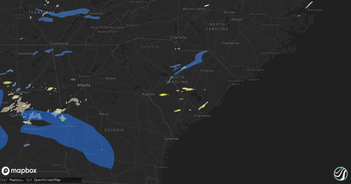
Hail Map in South Carolina on May 4, 2021
Get this storm
May 4 map
$229
one time, instant access
Download today. No call, no setup
Keep the $229
Bought the map and want the full workflow? Apply the entire $229 to a subscription within 7 days. None of it is wasted.
Every map, not just this one
This buys you this map. Subscription and you get every map we run, in the markets you choose from a few cities to whole states to nationwide. Plus real-time alerts the moment a storm fires.
Contact data
Name, contact info, occupancy, even credit band for addresses in the footprint. You go from where it hit to who to call.
Become the source they trust
Unlimited branding weather history reports on demand. You already have the documented answer ready for the property owner, and you are the one who showed up with it.
Property data and RoofTrace estimates
Pull up any address you have got, its value and the exact code rules for that jurisdiction, straight from One Click Code. Then RoofTrace estimates the squares, pitch, and roof value, priced the way you price.
Storm reports in South Carolina
South Carolina
| Date | Description |
|---|---|
| 05/04/20216:55 PM CDT | Sc patrol reports tree down on road at indiantown swamp rd and sc-261. Time estimated via radar. |
| 05/04/20216:28 PM CDT | Tree in roadway at rehoboth road and muckenfus road. Time estimated from radar. |
| 05/04/20216:25 PM CDT | Tree in roadway at round o road and fennel drive. Time estimated from radar. |
| 05/04/20216:19 PM CDT | Tree in roadway at welch creek and coolers dairy road. Vehicle collided with the downed tree. Time estimated from radar. |
| 05/04/20216:16 PM CDT | Tree in roadway at us15 and robertson blvd. Time estimated from radar. |
| 05/04/20216:15 PM CDT | Tree down at pleasant grove rd and maple ridge rd. Time estimated from time of report and radar. |
| 05/04/20216:14 PM CDT | Tree down at jefferies hwy and lakeshore dr. Time estimated from report time and radar. |
| 05/04/20216:13 PM CDT | Tree in roadway at cougar nation dr and jefferies highway. |
| 05/04/20216:03 PM CDT | Tree in roadway at peirce road and rhode drive. Time estimated from radar. |
| 05/04/20216:03 PM CDT | Tree in roadway at peirce road and whites ave. Time estimated from radar. |
| 05/04/20216:00 PM CDT | Tree in roadway at tabor road and bells highway. Time estimated from radar. |
| 05/04/20215:57 PM CDT | Road blocked due to a tree down at bad ham lane and low country highway. Time estimated from radar. |
| 05/04/20215:56 PM CDT | Trees down along i-26. |
| 05/04/20215:18 PM CDT | Tree in roadway at wee hope loop and bonnie doon road. Time estimated from radar. |
| 05/04/20215:12 PM CDT | Broadcast reporter shared pictures of a fallen tree on a car. Time estimated via radar. |
| 05/04/20215:10 PM CDT | Sc patrol reports tree down on roadway at sc-381 and chelsea lane. Time estimated via radar. |
| 05/04/20215:00 PM CDT | Sc patrol reports tree down on roadway at sandy grove rd and hebron dunbar rd. Time estimated via radar. |
| 05/04/20215:00 PM CDT | Sc patrol reports tree down on roadway at zion rd and marlboro way. Time estimated via radar. |
| 05/04/20214:55 PM CDT | Sc highway patrol reports tree blocking roadway at ivy rd and us1. Time estimated by radar. |
| 05/04/20214:50 PM CDT | Sc patrol reports tree down on roadway at hickory grove rd and sc-9. Time estimated via radar. |
| 05/04/20214:50 PM CDT | Sc patrol reports tree down on roadway at aaron temple church rd and old wire rd w. Time estimated via radar. |
| 05/04/20214:41 PM CDT | Richland co emergency planner reports power lines arcing – tree on fire from power line. |
| 05/04/20214:35 PM CDT | *** 1 inj *** large tree on a camper on easterling landing rd. |
| 05/04/20214:34 PM CDT | Sc patrol reports multiple trees down in roadways north and northeast of the hartsville area. Sc 102 & patrick hwy. Lakeview blvd & jessamine dr. Sun valley dr & ousley |
| 05/04/20214:33 PM CDT | Sc highway patrol reports tree down along trolly line rd near proud pacer. Time estimated by radar. |
| 05/04/20214:30 PM CDT | Beech island fire department reports tree blocking roadway and power line down on sheraton drive. Time estimated by radar. |
| 05/04/20214:30 PM CDT | Sc highway patrol reports tree in roadway at cedar creek rd and underground branch rd. Time estimated by radar. |
| 05/04/20213:45 PM CDT | Public report of tree falling on house with exterior damage only. Time estimated by radar. |
| 05/04/20213:38 PM CDT | Multiple trees down along i77 north of blythewood rd. Video of damage posted by member of the public via twitter. Time estimated by radar. |
| 05/04/20213:37 PM CDT | Multiple power lines down across lockhart rd near north central middle school. Photo sent via social media. |
| 05/04/20213:35 PM CDT | Spotter reported 72 mph wind gust with home weather station on longtown rd... Ridgeway sc. |
| 05/04/20213:35 PM CDT | Sc highway patrol reports tree blocking roadway on i77 at exit 32nb. Time estimated by radar. |
| 05/04/20213:33 PM CDT | Cpd power lines downed by tree – 4 lanes blocked. |
| 05/04/20213:33 PM CDT | Social media report of quarter to half dollar size hail. Report relayed by local news station. Time estimated from radar. |
| 05/04/20213:30 PM CDT | Sc highway patrol reports trees and powerlines down at us 321 and roddy road. Time estimated by radar. |
| 05/04/20213:23 PM CDT | A national weather service storm survey team confirmed an ef1 tornado... With peak winds of 105 mph... And a maximum width of 300 yards near rion in fairfield county... |
| 05/04/20213:21 PM CDT | Highway patrol reports tree blocking roadway near i20 and monticello rd. |
| 05/04/20213:20 PM CDT | Richland co emergency planner reports power lines arcing – tree on power line and caught tree on fire. |
| 05/04/20213:18 PM CDT | Sc highway patrol reports trees blocking roadway along muller rd near pine grove rd. Time estimated by radar. |
| 05/04/20213:15 PM CDT | Retired nws employee reports partial roofing and siding ripped from houses near chapin elementary school as well as several trees down. Time estimated by radar. |
| 05/04/20213:14 PM CDT | Numerous trees snapped and uprooted in portrait hill neighborhood. |
| 05/04/20213:12 PM CDT | Airport asos measured 65 mph peak gust. |
| 05/04/20213:05 PM CDT | Sc highway patrol reports trees in roadway at i20 exit 55. Time estimated by radar. |
| 05/04/20213:05 PM CDT | Sc highway patrol reports trees blocking roadway at old lexington highway and sid brickley rd. Time estimated by radar. |
| 05/04/20212:42 AM CDT | At 742 PM EDT, a severe thunderstorm was located near Kingstree, moving east at 35 mph. HAZARD...60 mph wind gusts and quarter size hail. SOURCE...Radar indicated. IMPACT...Minor hail damage to vehicles is possible. Expect wind damage to trees and power lines. Locations impacted include... Lake City, Johnsonville, Hemingway, Rhems, Warsaw, Hannah, Poston, Oatland, Nesmith, Indiantown, Outland, Gresham, Morrisville, Henry, Kingsburg, Scranton, Stuckey and Lake City Community Hospital. |
| 05/04/20212:04 AM CDT | At 704 PM EDT, a severe thunderstorm was located 8 miles east of Manning, moving east at 30 mph. HAZARD...60 mph wind gusts and quarter size hail. SOURCE...Radar indicated. IMPACT...Minor hail damage to vehicles is possible. Expect wind damage to trees and power lines. Locations impacted include... Lake City, Kingstree, Salters, Hebron, Cades, Scranton, Coward, Lane, Greeleyville, Central Crossroads, Lake City Community Hospital and Williamsburg Regional Hospital. |
| 05/04/20211:59 AM CDT | At 659 PM EDT, severe thunderstorms were located along a line extending from near Lodge to near Walterboro, moving northeast at 35 mph. HAZARD...60 mph wind gusts and quarter size hail. SOURCE...Radar indicated. IMPACT...Minor hail damage to vehicles is possible. Expect wind damage to trees and powerlines. Locations impacted include... Walterboro, Saint George, Givhans Ferry State Park, Dorchester, Colleton, Ridgeville, Cottageville, Harleyville, Reevesville, Smoaks, Lodge, Williams, Givhans, Ruffin and Jedburg.This warning includes... I-26 between mile markers 171 and 189. I-95 in South Carolina between mile markers 53 and 85. |
| 05/04/20211:57 AM CDT | At 657 PM EDT, a severe thunderstorm was located over Manning, moving east at 35 mph. HAZARD...60 mph wind gusts and quarter size hail. SOURCE...Radar indicated. IMPACT...Hail damage to vehicles is expected. Expect wind damage to roofs, siding, and trees. Locations impacted include... Manning, Summerton, Santee Cooper Regional Airport, Alcolu, Turbeville, Paxville, Gable, Davis Station and Foreston.This includes Interstate 95 between mile markers 106 and 133. |
| 05/04/20211:30 AM CDT | At 630 PM EDT, severe thunderstorms were located along a line extending from near Aberdeen to near South Of The Border, moving northeast at 40 mph. HAZARD...60 mph wind gusts. SOURCE...Radar indicated. IMPACT...Expect wind damage to trees and power lines. Locations impacted include... Red Springs, Pembroke, Maxton, Rex, Raemon, Shannon, Buie, Wakulla, Purvis, Prospect, Minturn, Elrod, Parkton, Rennert and Lumber Bridge. |
| 05/04/20211:17 AM CDT | At 617 PM EDT, severe thunderstorms were located along a line extending from Ritter to near Ashepoo to near Bennetts Point, moving northeast at 40 mph. HAZARD...60 mph wind gusts and quarter size hail. SOURCE...Radar indicated. IMPACT...Minor hail damage to vehicles is possible. Expect wind damage to trees and powerlines. Locations impacted include... North Charleston, Mount Pleasant, Summerville, Goose Creek, Hanahan, Walterboro, Edisto Beach, Fort Sumter, Downtown Charleston, West Ashley, Daniel Island, Givhans Ferry State Park, Naval Weapons Station Charleston, Johns Island and Ladson.This warning includes... I-26 between mile markers 190 and 221. I-526 between mile markers 11 and 31. I-95 in South Carolina between mile markers 47 and 50. |
| 05/04/20211:07 AM CDT | At 607 PM EDT, severe thunderstorms were located along a line extending from near Clyde to near St. Matthews, moving southeast at 45 mph. HAZARD...60 mph wind gusts and quarter size hail. SOURCE...Radar indicated. IMPACT...Hail damage to vehicles is expected. Expect wind damage to roofs, siding, and trees. Locations impacted include... Sumter, Manning, Bishopville, South Sumter, Shaw Air Base, McEntire Air Base, Summerton, Eastover, Oakland, Mulberry, Congaree National Park, Alcolu, Woods Bay State Park, Santee Cooper Regional Airport, Elliott, Lee State Park, Sumter County Airport, Gadsden, Millwood and Poinsett State Park.This includes the following highways... Interstate 20 in South Carolina between mile markers 106 and 125. Interstate 95 between mile markers 102 and 146. |
| 05/04/202112:57 AM CDT | At 557 PM EDT, a severe thunderstorm was located near Bennettsville, moving east at 55 mph. HAZARD...70 mph wind gusts and penny size hail. SOURCE...Radar indicated. IMPACT...Expect considerable tree damage. Damage is likely to mobile homes, roofs, and outbuildings. Locations impacted include... Bennettsville, Pembroke, Maxton, Mccoll, Rowland, Clio, Raemon, Mont Clare, Wallace, Wakulla, Chavistown, Purvis, Prospect, Dunbar, Minturn, Elrod, Society Hill, Gibson, Blenheim and Mcdonald. |
| 05/04/202112:37 AM CDT | At 537 PM EDT, a severe thunderstorm was located near Cheraw Municipal Airport, or 7 miles west of Cheraw, moving northeast at 40 mph. HAZARD...60 mph wind gusts and penny size hail. SOURCE...Radar indicated. IMPACT...Expect damage to roofs, siding, and trees. Locations impacted include... Laurinburg, Rockingham, Hamlet, Maxton, Hoffman, Dobbins Heights, Wagram, Gibson, Morven and East Laurinburg. |
| 05/04/202112:30 AM CDT | At 529 PM EDT, severe thunderstorms were located along a line extending from 8 miles southwest of Red Bank to near Hephzibah, moving southeast at 25 mph. Additional isolated severe thunderstorms were also located ahead of this line. HAZARD...60 mph wind gusts. SOURCE...Radar indicated. IMPACT...Expect damage to roofs, siding, and trees. Locations impacted include... Aiken, North Augusta, Waynesboro, Fort Gordon, Augusta, Clearwater, Savannah River Site, Aiken Mall, Plant Vogtle, Belvedere, Red Bank, Hephzibah, Williston, Blackville, New Ellenton, Jackson, Glendale, South Augusta, Summerville and Augusta Mall.This includes the following highways... Interstate 20 in South Carolina between mile markers 3 and 50. Interstate 520 in Georgia between mile markers 2 and 15. Interstate 520 in South Carolina between mile markers 16 and 23. |
| 05/04/202112:08 AM CDT | At 508 PM EDT, a severe thunderstorm was located near Cassatt, or 16 miles northeast of Camden, moving east at 60 mph. HAZARD...60 mph wind gusts and penny size hail. SOURCE...Radar indicated. IMPACT...Expect wind damage to trees and power lines. Locations impacted include... Bennettsville, Hartsville, Clio, North Hartsville, Dovesville, Mont Clare, Auburn, Wallace, Clyde, Chavistown, Floyd, Dunbar, Kellytown, Society Hill, Blenheim, Tatum and Carolina Pines Regional Medical Center. |
| 05/04/202112:03 AM CDT | At 502 PM EDT, severe thunderstorms were located along a line extending from 6 miles northwest of Pageland to Goodale State Park, moving northeast at 60 mph. HAZARD...60 mph wind gusts. SOURCE...Radar indicated. IMPACT...Expect damage to roofs, siding, and trees. Locations impacted include... Cheraw, Pageland, Chesterfield, Cheraw State Park, Northeastern Technical College, Cassatt, Cheraw Municipal Airport, Carolina Sandhills Wildlife Refuge, Mt Pisgah, Goodale State Park, Mcbee, Jefferson, Ruby, Patrick, Bethune, Mount Croghan, Lucknow, Chesterfield Ruby Middle School, North Central High School and Cheraw Fish Hatchery. |
| 05/03/202111:46 PM CDT | At 446 PM EDT, severe thunderstorms were located along a line extending from near Jenkinsville to 7 miles south of Prosperity, moving east at 45 mph. HAZARD...60 mph wind gusts. SOURCE...Radar indicated. IMPACT...Expect damage to roofs, siding, and trees. Locations impacted include... Columbia, Lexington, West Columbia, Cayce, Irmo, Forest Acres, Springdale, St. Andrews, Dentsville, Oak Grove, Highway 6 at Lake Murray Dam, Red Bank, South Congaree, Pine Ridge, Gaston, Arcadia Lakes, Columbia International University, Jenkinsville, Harbison State Forest and Sesquicentennial State Park.This includes the following highways... Interstate 126 between mile markers 0 and 3. Interstate 20 in South Carolina between mile markers 51 and 82. Interstate 26 between mile markers 84 and 120. Interstate 77 between mile markers 0 and 26. |
| 05/03/202111:38 PM CDT | At 437 PM EDT, severe thunderstorms were located along a line extending from near Saluda County Airport to near Wrightsboro, moving east at 20 mph. HAZARD...60 mph wind gusts and penny size hail. SOURCE...Radar indicated. IMPACT...Expect damage to roofs, siding, and trees. Locations impacted include... North Augusta, Grovetown, Evans, Thomson, Batesburg-Leesville, Martinez, Edgefield, Saluda, McCormick, Harlem, Johnston, Lincolnton, Ridge Spring, Clarks Hill Recreation Area, Edgefield County Airport, Elijah Clark State Park, Mistletoe State Park, Wrightsboro, Village Plaza Shopping Center and J. Strom Thurmond Dam.This includes Interstate 20 in Georgia between mile markers 167 and198. |
| 05/03/202111:30 PM CDT | At 430 PM EDT, severe thunderstorms were located along a line extending from 6 miles north of Crowfield Plantation to near Huger, moving northeast at 30 mph. HAZARD...60 mph wind gusts and nickel size hail. SOURCE...Radar indicated. IMPACT...Expect damage to trees and powerlines. Locations impacted include... Moncks Corner, Jamestown, Old Santee Canal State Park and Huger. |
| 05/03/202111:16 PM CDT | At 415 PM EDT, severe thunderstorms were located along a line extending from VC Summer Nuclear Station to SC State Fair Grounds, moving northeast at 60 mph. An addition line of severe thunderstorms were also approaching from the northwest. HAZARD...70 mph wind gusts and quarter size hail. SOURCE...Radar indicated. IMPACT...Hail damage to vehicles is expected. Expect considerable tree damage. Wind damage is also likely to mobile homes, roofs, and outbuildings. Locations impacted include... Columbia, Forest Acres, Camden, Winnsboro, Lake Wateree Dam, Dentsville, Arcadia Lakes, Lugoff, Fairfield County Airport, Villages at Sandhill, Jenkinsville, Liberty Hill, Elgin, Killian, Woodfield, Sesquicentennial State Park, Lake Carolina, Longtown, Fort Jackson and Goodale State Park.This includes the following highways... Interstate 20 in South Carolina between mile markers 70 and 102. Interstate 77 between mile markers 13 and 46. |
| 05/03/202111:15 PM CDT | At 415 PM EDT, severe thunderstorms were located along a line extending from near Sangaree to near Naval Weapons Station Charleston, moving northeast at 30 mph. HAZARD...60 mph wind gusts and quarter size hail. SOURCE...Radar indicated. IMPACT...Minor hail damage to vehicles is possible. Expect wind damage to trees and powerlines. Locations impacted include... Summerville, Goose Creek, Moncks Corner, Naval Weapons Station Charleston, Ladson, Sangaree, Crowfield Plantation and College Park.This warning includes I-26 between mile markers 198 and 200. |
| 05/03/202111:00 PM CDT | At 359 PM EDT, severe thunderstorms were located along a line extending from 6 miles north of Blair to near Lake Greenwood State Park, moving northeast at 30 mph. HAZARD...60 mph wind gusts and quarter size hail. SOURCE...Radar indicated. IMPACT...Hail damage to vehicles is expected. Expect wind damage to roofs, siding, and trees. Locations impacted include... Newberry, VC Summer Nuclear Station, Saluda, Whitmire, Prosperity, Newberry College, Monticello, Newberry County Airport, Blair, Pomaria, Silverstreet, Lebanon Fire Station, US-176 and SC- 34 Crossroads, Good Hope, Henderson Island, Belfast Wildlife Management Area, Mitford, Hollywood Elementary School, Chappells Fire Station and White Oak.This includes the following highways... Interstate 26 between mile markers 62 and 84. Interstate 77 between mile markers 47 and 50. |
| 05/03/202110:54 PM CDT | At 354 PM EDT, a severe thunderstorm was located over Van Wyck, or 7 miles south of Indian Land, moving northeast at 35 mph. HAZARD...60 mph wind gusts and quarter size hail. SOURCE...Radar indicated. IMPACT...Hail damage to vehicles is expected. Expect wind damage to roofs, siding, and trees. Locations impacted include... Indian Land, Andrew Jackson State Park, Van Wyck, Carolina Commons Shopping Center, Community of Almond Glen and Unity Fire Station. |
| 05/03/202110:53 PM CDT | At 353 PM EDT, a severe thunderstorm was located 6 miles southeast of Rock Hill, or near Lesslie, moving east at 40 mph. HAZARD...70 mph wind gusts and penny size hail. SOURCE...Radar indicated. IMPACT...Expect considerable tree damage. Damage is likely to mobile homes, roofs, and outbuildings. Locations impacted include... Rock Hill, Monroe, Indian Trail, Weddington, Stallings, Unionville, Wesley Chapel, Wingate, Waxhaw and Lake Park. |
| 05/03/202110:52 PM CDT | At 352 PM EDT, a severe thunderstorm was located 7 miles west of Gaston, or 8 miles south of Red Bank, moving northeast at 35 mph. HAZARD...60 mph wind gusts and quarter size hail. SOURCE...Radar indicated. IMPACT...Hail damage to vehicles is expected. Expect wind damage to roofs, siding, and trees. Locations impacted include... Columbia, Lexington, West Columbia, Cayce, Irmo, Forest Acres, Batesburg-Leesville, Springdale, St. Andrews, Highway 6 at Lake Murray Dam, Red Bank, Oak Grove, South Congaree, Pine Ridge, Gaston, Hopkins, Columbia International University, Harbison State Forest, Riverbanks Zoo and SC State Farmer's Market.This includes the following highways... Interstate 126 between mile markers 0 and 3. Interstate 20 in South Carolina between mile markers 42 and 70. Interstate 26 between mile markers 102 and 125. Interstate 77 between mile markers 0 and 12. |
| 05/03/202110:45 PM CDT | At 345 PM EDT, a severe thunderstorm was located near Saluda, or 9 miles northwest of Batesburg-Leesville, moving northeast at 35 mph. HAZARD...60 mph wind gusts and quarter size hail. SOURCE...Radar indicated. IMPACT...Hail damage to vehicles is expected. Expect wind damage to roofs, siding, and trees. Locations impacted include... Irmo, Batesburg-Leesville, Saluda, Prosperity, Dreher Island State Park, Ballentine, Chapin, Little Mountain, Pomaria, Peak, Cedar Grove Fire Station, South Shore Marina, Oswald Park, Saluda Co Sheriff's Office, Bundrick Island, Putnam's Landing, White Rock, Rocky Point Recreation Area, Hollywood Elementary School and Emory.This includes Interstate 26 between mile markers 80 and 100. |
All States Impacted by Hail Map on May 4, 2021
Cities Impacted by Hail Map on May 4, 2021
- Saulsbury, TN
- Walnut, MS
- Ashland, MS
- Michigan City, MS
- Morton, MS
- Pelahatchie, MS
- Sulphur, LA
- French Settlement, LA
- Maurepas, LA
- Saint Amant, LA
- Clanton, AL
- Verbena, AL
- Billingsley, AL
- Martindale, TX
- Milam, WV
- Bergton, VA
- Moorefield, WV
- Waterford, MS
- Como, MS
- Holly Springs, MS
- Abbeville, MS
- Ruleville, MS
- Doddsville, MS
- Cleveland, MS
- Valley, AL
- Opelika, AL
- Hamilton, GA
- Cusseta, AL
- West Point, GA
- Salem, AL
- Smithville, TX
- Palacios, TX
- Florence, MS
- Frierson, LA
- Stonewall, LA
- Quicksburg, VA
- New Market, VA
- Timberville, VA
- Mount Jackson, VA
- Weogufka, AL
- Equality, AL
- Eclectic, AL
- Rockford, AL
- Alexander City, AL
- Elmore, AL
- Titus, AL
- Prattville, AL
- Deatsville, AL
- Wetumpka, AL
- Millbrook, AL
- Marbury, AL
- Ashburn, GA
- Pheba, MS
- Maben, MS
- Lamar, MS
- Bastrop, TX
- Red Rock, TX
- Cedar Creek, TX
- Florien, LA
- Steeles Tavern, VA
- Greenville, VA
- Raphine, VA
- Heflin, AL
- Anniston, AL
- Sardis, MS
- Crenshaw, MS
- Wilsonville, AL
- Columbiana, AL
- Gary, TX
- Tenaha, TX
- Timpson, TX
- Cameron, SC
- Effie, LA
- Jonesville, LA
- Marksville, LA
- Pennington, TX
- Groveton, TX
- Apple Springs, TX
- Kennard, TX
- Nacogdoches, TX
- Lafayette, AL
- Camp Hill, AL
- Five Points, AL
- Lanett, AL
- Moorhead, MS
- Indianola, MS
- Bienville, LA
- Crosby, MS
- Brent, AL
- Williston, SC
- Bedford, VA
- Big Island, VA
- Rolling Fork, MS
- Glen Allan, MS
- Hollandale, MS
- Mayersville, MS
- Anguilla, MS
- Lumberton, TX
- Kountze, TX
- Lockhart, TX
- Caldwell, TX
- Jasper, AL
- Vesuvius, VA
- Tyro, VA
- Montebello, VA
- Draper, VA
- Hamburg, AR
- Ragley, LA
- Starks, LA
- Lake Charles, LA
- Longville, LA
- Mittie, LA
- Dequincy, LA
- Oakdale, LA
- Kinder, LA
- Singer, LA
- Oberlin, LA
- Dry Creek, LA
- Iowa, LA
- Reeves, LA
- Warrior, AL
- Dora, AL
- Empire, AL
- Brenham, TX
- Ruffin, SC
- Islandton, SC
- Lovelady, TX
- Trinity, TX
- Amite, LA
- Holden, LA
- Walker, LA
- Dale, TX
- Dermott, AR
- Goode, VA
- Fulks Run, VA
- Broadway, VA
- Mathias, WV
- Criders, VA
- Middlebrook, VA
- Kyle, TX
- Philadelphia, MS
- Carthage, MS
- Jemison, AL
- Luray, VA
- Gloster, MS
- Centreville, MS
- Baytown, TX
- Brandywine, WV
- Franklin, WV
- Greenville, MS
- Windsor, SC
- Blackville, SC
- Parrish, AL
- Cordova, AL
- Montrose, AR
- Crossett, AR
- Woodville, MS
- Batchelor, LA
- Bessemer, AL
- Birmingham, AL
- McCalla, AL
- Huntington, TX
- Dayton, TX
- Amissville, VA
- Sperryville, VA
- Flint Hill, VA
- Washington, VA
- Woodville, VA
- Castleton, VA
- Saltillo, MS
- Jackson, MS
- Crystal Springs, MS
- Giddings, TX
- La Grange, TX
- Summerton, SC
- Pinewood, SC
- Gibsland, LA
- Lufkin, TX
- Greensburg, LA
- Orangeburg, SC
- Pleasant Shade, TN
- Haughton, LA
- Elm Grove, LA
- Lake, MS
- Browns Summit, NC
- Greensboro, NC
- Summerfield, NC
- Canton, MS
- Brandon, MS
- Hiwassee, VA
- Roxie, MS
- Meadville, MS
- Pulaski, MS
- Forest, MS
- Raleigh, MS
- Fairfield, VA
- Buena Vista, VA
- Lexington, VA
- Ledbetter, TX
- Huffman, TX
- Lexington, TX
- Rockdale, TX
- Lagrange, GA
- Camden, SC
- Jamestown, LA
- Castor, LA
- Cary, MS
- Burton, TX
- Calera, AL
- Shelby, AL
- Potts Camp, MS
- Oxford, MS
- Shreveport, LA
- McDade, TX
- Elgin, TX
- Carmine, TX
- Satartia, MS
- Sylacauga, AL
- Vidalia, LA
- Ackerman, MS
- Eupora, MS
- Mathiston, MS
- Crosby, TX
- Hickory Flat, MS
- Myrtle, MS
- Madison, MS
- Ridgeland, MS
- Clinton, MS
- Camden, MS
- Woodbury, TN
- Summit, MS
- Smithdale, MS
- Simmesport, LA
- Lettsworth, LA
- Jacksonville, AL
- Eagle Rock, VA
- Clifton Forge, VA
- Booneville, MS
- Georgetown, MS
- Harrisville, MS
- Huger, SC
- Cordesville, SC
- Moncks Corner, SC
- Taylorsville, MS
- Eros, LA
- West Monroe, LA
- Hornbeck, LA
- Woodbridge, VA
- Keithville, LA
- Marietta, MS
- Bastrop, LA
- Saint Matthews, SC
- Jamaica, VA
- Lancaster, VA
- Little Plymouth, VA
- Church View, VA
- Urbanna, VA
- Water View, VA
- Bentonia, MS
- Vaughan, MS
- McCarley, MS
- Winona, MS
- Coila, MS
- Elloree, SC
- Collinston, LA
- Mer Rouge, LA
- Tallulah, LA
- Watson, AR
- Vidor, TX
- Hazlehurst, MS
- Kingsbury, TX
- San Marcos, TX
- Noxapater, MS
- New Albany, MS
- South Mills, NC
- Mendenhall, MS
- Magee, MS
- Cheneyville, LA
- Denham Springs, LA
- Murfreesboro, TN
- Mount Olive, MS
- Mize, MS
- Bryan, TX
- Cherokee, AL
- Benton, MS
- Waverly, AL
- Dunnsville, VA
- Baldwyn, MS
- Saint Martinville, LA
- Round Top, TX
- Brooks, GA
- Senoia, GA
- Rayville, LA
- Gay, GA
- Luthersville, GA
- Greenville, GA
- Catherine, AL
- Camden, AL
- Edinburg, VA
- Orkney Springs, VA
- Amherst, VA
- Poplar Branch, NC
- Grandy, NC
- Collinsville, MS
- Rockbridge Baths, VA
- Tuscumbia, AL
- Liberty, TN
- Dowelltown, TN
- Smithville, TN
- Union, MS
- Decatur, MS
- Sunbury, NC
- Corapeake, NC
- Little Rock, MS
- Chunky, MS
- Hickory, MS
- Meridian, MS
- Newton, MS
- New Braunfels, TX
- Centreville, AL
- Banner, MS
- Water Valley, MS
- Somerville, TX
- Columbia, NC
- Navasota, TX
- Marion, LA
- Braxton, MS
- Pearl, MS
- Terry, MS
- Byram, MS
- Richland, MS
- Louin, MS
- Starkville, MS
- Suffolk, VA
- Farmerville, LA
- Hogansville, GA
- Franklin, GA
- Coffeeville, MS
- Itta Bena, MS
- Greenwood, MS
- Schlater, MS
- Bay Springs, MS
- De Kalb, MS
- Eutaw, AL
- Maxwell, TX
- Seguin, TX
- Bruce, MS
- Sunflower, MS
- Manning, SC
- Sharpsburg, GA
- Grantville, GA
- Moreland, GA
- Newnan, GA
- Warrenton, VA
- Catlett, VA
- Epps, LA
- Dadeville, AL
- Bunkie, LA
- Paige, TX
- Delta, AL
- Leesville, LA
- Bryans Road, MD
- Inverness, MS
- Tappahannock, VA
- Champlain, VA
- Ralph, AL
- Gore Springs, MS
- Grenada, MS
- Saint Landry, LA
- Deridder, LA
- Fort Polk, LA
- Pitkin, LA
- Maplesville, AL
- Thorsby, AL
- Brierfield, AL
- Pelham, AL
- Childersburg, AL
- Alabaster, AL
- Montevallo, AL
- Helena, AL
- Randolph, AL
- Bude, MS
- Liberty, MS
- Cedarbluff, MS
- West Point, MS
- Golden, MS
- Oakman, AL
- Adger, AL
- Trussville, AL
- Odenville, AL
- Monroe, LA
- Lake Village, AR
- Flora, MS
- Lugoff, SC
- Pontotoc, MS
- Accokeek, MD
- Indian Head, MD
- Muscle Shoals, AL
- Leighton, AL
- Catawba, SC
- Rock Hill, SC
- Lorton, VA
- Ragland, AL
- Pell City, AL
- Pinola, MS
- Livingston, LA
- Buchanan, VA
- Nokesville, VA
- Waldorf, MD
- Manassas, VA
- Dumfries, VA
- Warsaw, VA
- Granville, TN
- Gainesboro, TN
- Salters, SC
- Ethel, LA
- Clinton, LA
- Slaughter, LA
- McGehee, AR
- Arkansas City, AR
- Lancaster, SC
- Ruth, MS
- Jeanerette, LA
- Boligee, AL
- Lake Providence, LA
- Boyle, MS
- Cottageville, SC
- Ridgeville, SC
- Natchez, MS
- Manor, TX
- Corolla, NC
- Shiloh, NC
- Downsville, LA
- Moreauville, LA
- Stuarts Draft, VA
- Lyndhurst, VA
- Fayetteville, TN
- Frankewing, TN
- Leland, MS
- West Blocton, AL
- Townley, AL
- Charleston, SC
- Goose Creek, SC
- Ladson, SC
- North Charleston, SC
- Minter City, MS
- Philipp, MS
- Charleston, MS
- Pierre Part, LA
- Oak Ridge, LA
- Sterlington, LA
- Marshall, TX
- Evergreen, LA
- Morrow, LA
- Washington, LA
- Griffin, GA
- Weir, MS
- Newhebron, MS
- Chatham, LA
- Austin, TX
- Waskom, TX
- Oak Grove, LA
- Beulah, MS
- Benoit, MS
- Lawrence, MS
- Conehatta, MS
- Greenfield, TN
- Sharon, TN
- Martin, TN
- McBee, SC
- Monticello, AR
- Springville, AL
- Holcomb, MS
- Bedias, TX
- Adamsville, AL
- Petersburg, WV
- Hearne, TX
- Marshall, VA
- Duck Hill, MS
- Mississippi State, MS
- Duncanville, AL
- Moundville, AL
- Lena, MS
- Ringgold, LA
- Livingston, TX
- Cookeville, TN
- Monterey, TN
- Bossier City, LA
- Chestnut Mound, TN
- Elmwood, TN
- Del Valle, TX
- Shaw, MS
- Ranburne, AL
- Tishomingo, MS
- New Site, MS
- Bernice, LA
- Glasgow, VA
- Natural Bridge, VA
- Oxford, AL
- Yazoo City, MS
- Grand Cane, LA
- Mansfield, LA
- Calhoun, LA
- Jonesboro, LA
- Natchitoches, LA
- Campti, LA
- Goldonna, LA
- Winnfield, LA
- Mangham, LA
- Hollytree, AL
- Woodville, AL
- Paint Rock, AL
- Trenton, AL
- Scottsboro, AL
- Lynn, AL
- Double Springs, AL
- Haleyville, AL
- Houston, AL
- Nauvoo, AL
- Vinemont, AL
- Cullman, AL
- Addison, AL
- Arley, AL
- Logan, AL
- Bryant, AL
- Hollywood, AL
- Higdon, AL
- Stevenson, AL
- Flat Rock, AL
- Trenton, GA
- Rising Fawn, GA
- Pisgah, AL
- Gardendale, AL
- Fultondale, AL
- Mount Olive, AL
- Sumiton, AL
- Fort Deposit, AL
- Honoraville, AL
- Greenville, AL
- Pitts, GA
- Smiths Station, AL
- Preston, GA
- Cataula, GA
- Leslie, GA
- Rochelle, GA
- Ellenton, GA
- Adel, GA
- Reynolds, GA
- Pike Road, AL
- Oglethorpe, GA
- Omaha, GA
- De Soto, GA
- Camilla, GA
- Alapaha, GA
- Fitzgerald, GA
- Baconton, GA
- Ocilla, GA
- Warwick, GA
- Tallassee, AL
- Plains, GA
- Albany, GA
- Poulan, GA
- Andersonville, GA
- Columbus, GA
- Ideal, GA
- Rebecca, GA
- Box Springs, GA
- Ellaville, GA
- Talbotton, GA
- Shiloh, GA
- Oakfield, GA
- Unadilla, GA
- Pinehurst, GA
- Seale, AL
- Booth, AL
- Fitzpatrick, AL
- Hayneville, AL
- Lowndesboro, AL
- Buena Vista, GA
- Weston, GA
- Phenix City, AL
- Smithville, GA
- Auburn University, AL
- Georgetown, GA
- Tuskegee, AL
- Notasulga, AL
- Sparks, GA
- Ramer, AL
- Newton, GA
- Americus, GA
- Sale City, GA
- Bronwood, GA
- Cobb, GA
- Richland, GA
- Hardaway, AL
- Ty Ty, GA
- Ellerslie, GA
- Tifton, GA
- Sycamore, GA
- Enigma, GA
- Arabi, GA
- Fort Benning, GA
- Hurtsboro, AL
- Pittsview, AL
- Vienna, GA
- Cusseta, GA
- Fort Mitchell, AL
- Mauk, GA
- Tuskegee Institute, AL
- Byromville, GA
- Tyler, AL
- Fort Davis, AL
- Kellyton, AL
- Shellman, GA
- Autaugaville, AL
- Norman Park, GA
- Mathews, AL
- Rupert, GA
- Nashville, GA
- Sumner, GA
- Montgomery, AL
- Chula, GA
- Parrott, GA
- Junction City, GA
- Leesburg, GA
- Fortson, GA
- Marshallville, GA
- Shorter, AL
- Lumpkin, GA
- Upatoi, GA
- Eufaula, AL
- Clayton, AL
- Lenox, GA
- Butler, GA
- Midway, AL
- Moultrie, GA
- Jacksons Gap, AL
- Montezuma, GA
- Cuthbert, GA
- Midland, GA
- Auburn, AL
- Waverly Hall, GA
- Omega, GA
- Hatchechubbee, AL
- Doerun, GA
- Cordele, GA
- Morris, GA
- Sylvester, GA
- Cecil, AL
- Dawson, GA
- Hartsfield, GA
- Hope Hull, AL
- Pine Mountain, GA
- Union Springs, AL
- Dalton, GA
- Ringgold, GA
- Chatsworth, GA
- Rocky Face, GA
- La Fayette, GA
- Tunnel Hill, GA
- Rock Spring, GA
- Chickamauga, GA
- Powder Springs, GA
- Dallas, GA
- Hiram, GA
- Culpeper, VA
- Madison, VA
- Leon, VA
- Brightwood, VA
- Reva, VA
- Rochelle, VA
- Pratts, VA
- Arrington, VA
- Pelion, SC
- Columbia, SC
- Lexington, SC
- West Columbia, SC
- Cassatt, SC
- Patrick, SC
- Jefferson, SC
- Bethune, SC
- Cheraw, SC
- Wallace, SC
- Bishopville, SC
- Rockingham, NC
- Hartsville, SC
- Society Hill, SC
- Chesterfield, SC
- Bennettsville, SC
- Elgin, SC
- Hamlet, NC
- Blythewood, SC
- Ridgeway, SC
- Winnsboro, SC
- Norway, SC
- Branchville, SC
- Rowesville, SC
- Bowman, SC
- Clinton, MD
- Temple Hills, MD
- Andrews Air Force Base, MD
- Suitland, MD
- Fort Washington, MD
- Oxon Hill, MD
- Upper Marlboro, MD
- Brandywine, MD
- Coupland, TX
- Weedville, PA
- Pulaski, VA
- Roanoke, VA
- Bent Mountain, VA
- Christiansburg, VA
- Shawsville, VA
- Callaway, VA
- Check, VA
- Pilot, VA
- Radford, VA
- Riner, VA
- Copper Hill, VA
- Monroe, VA
- Troutville, VA
- Natural Bridge Station, VA
- Fincastle, VA
- Cloverdale, VA
- Thaxton, VA
- Coleman Falls, VA
- Montvale, VA
- Blue Ridge, VA
- Daleville, VA
- Salem, VA
- Fort Valley, VA
- Rileyville, VA
- Basye, VA
- Front Royal, VA
- Linden, VA
- Vienna, VA
- Dunn Loring, VA
- Falls Church, VA
- Fairfax, VA
- Spotsylvania, VA
- Secretary, MD
- Vienna, MD
- Great Mills, MD
- Bowling Green, VA
- Colonial Beach, VA
- Ruther Glen, VA
- Valley Lee, MD
- Madison, MD
- California, MD
- Columbia, VA
- Seaford, DE
- Avenue, MD
- Montross, VA
- Lexington Park, MD
- Chaptico, MD
- Crapo, MD
- Lusby, MD
- Fredericksburg, VA
- Hollywood, MD
- Louisa, VA
- Bushwood, MD
- Palmyra, VA
- Mineral, VA
- Church Creek, MD
- Kents Store, VA
- Bumpass, VA
- Trappe, MD
- Ellendale, DE
- Leonardtown, MD
- Newburg, MD
- Troy, VA
- Greenwood, DE
- Port Royal, VA
- Bridgeville, DE
- Issue, MD
- Woolford, MD
- Taylors Island, MD
- Fishing Creek, MD
- Georgetown, DE
- Callaway, MD
- Woodford, VA
- Partlow, VA
- Federalsburg, MD
- Rappahannock Academy, VA
- Abell, MD
- Solomons, MD
- Scottsville, VA
- Hurlock, MD
- Preston, MD
- Linkwood, MD
- Patuxent River, MD
- Park Hall, MD
- Drayden, MD
- Clements, MD
- Mechanicsville, MD
- Loveville, MD
- King George, VA
- Rhodesdale, MD
- Tall Timbers, MD
- Montpelier, VA
- Dowell, MD
- Beaverdam, VA
- East New Market, MD
- Coltons Point, MD
- Cobb Island, MD
- Milford, VA
- Cambridge, MD
- Milton, DE
- Stony Creek, VA
- Jarratt, VA
- Waverly, VA
- Emporia, VA
- Yale, VA
- Carson, VA
- Dinwiddie, VA
- Disputanta, VA
- Fort Monroe, VA
- Zuni, VA
- Smithfield, VA
- Hampton, VA
- Windsor, VA
- Carrollton, VA
- Newport News, VA
- Alexandria, TN
- Watertown, TN
- Oak Ridge, TN
- Harriman, TN
- Rockwood, TN
- Clinton, TN
- Pleasant Hill, TN
- Crab Orchard, TN
- Oliver Springs, TN
- Crossville, TN
- Sparta, TN
- Walling, TN
- Wartburg, TN
- Oakdale, TN
- Rock Island, TN
- Mcminnville, TN
- Bradyville, TN
- Louisville, TN
- Walland, TN
- Farragut, TN
- Maryville, TN
- Seymour, TN
- Rockford, TN
- Knoxville, TN
- Alcoa, TN
- Lenoir City, TN
- Carrollton, MS
- Emelle, AL
- Franklinton, LA
- Lisman, AL
- Mantee, MS
- Louise, MS
- Redwood, MS
- Hamilton, AL
- Akron, AL
- North Carrollton, MS
- Kosciusko, MS
- Dickinson, AL
- Bellamy, AL
- Goodman, MS
- Vina, AL
- Bogue Chitto, MS
- Louisville, MS
- Petal, MS
- Shubuta, MS
- Bailey, MS
- Daleville, MS
- Roseland, LA
- Epes, AL
- Shuqualak, MS
- Sidon, MS
- Raymond, MS
- Brookhaven, MS
- Gainesville, AL
- Newbern, AL
- Lumberton, MS
- Mccomb, MS
- Forkland, AL
- Marion, MS
- Flowood, MS
- Fayette, MS
- Buckatunna, MS
- Gallion, AL
- Ovett, MS
- Lexington, MS
- York, AL
- Edwards, MS
- Orrville, AL
- Quitman, MS
- Fluker, LA
- Loranger, LA
- Bassfield, MS
- Big Creek, MS
- Ward, AL
- Lauderdale, MS
- Kentwood, LA
- Cascilla, MS
- Laurel, MS
- Sumrall, MS
- Hermanville, MS
- Pine Grove, LA
- Sawyerville, AL
- Walthall, MS
- Glendora, MS
- Cottondale, AL
- Houlka, MS
- Tremont, MS
- Silver Creek, MS
- West, MS
- Toomsuba, MS
- Pine Hill, AL
- Smithville, MS
- Greenwood Springs, MS
- Holly Bluff, MS
- Sandy Hook, MS
- Coffeeville, AL
- Durant, MS
- Bellefontaine, MS
- Paulding, MS
- Frankville, AL
- McCall Creek, MS
- Calhoun City, MS
- Jayess, MS
- Foxworth, MS
- Wesson, MS
- Walnut Grove, MS
- Ferriday, LA
- Greensboro, AL
- Whatley, AL
- Safford, AL
- Vossburg, MS
- Rose Hill, MS
- Norwood, LA
- Oak Vale, MS
- Scooba, MS
- Tylertown, MS
- Pennington, AL
- Saint Francisville, LA
- Gordo, AL
- Tuscaloosa, AL
- Bolton, MS
- Fulton, MS
- Port Gibson, MS
- Echola, AL
- Vaiden, MS
- Jackson, LA
- Uniontown, AL
- Gilbertown, AL
- Shannon, MS
- Magnolia, AL
- Coker, AL
- Vardaman, MS
- Macon, MS
- Elrod, AL
- Coy, AL
- Seminary, MS
- Amory, MS
- Buhl, AL
- Kilmichael, MS
- Monticello, MS
- Prairie, MS
- Kokomo, MS
- Saint Stephens, AL
- State Line, MS
- Preston, MS
- Butler, AL
- Hattiesburg, MS
- Pickens, MS
- Newellton, LA
- Needham, AL
- Purvis, MS
- Tinsley, MS
- Ellisville, MS
- Wilson, LA
- Cruger, MS
- Scobey, MS
- Sallis, MS
- Aberdeen, MS
- Moselle, MS
- Thomasville, AL
- Osyka, MS
- Plantersville, MS
- Dixons Mills, AL
- Soso, MS
- Jachin, AL
- Grove Hill, AL
- Silver City, MS
- Hackleburg, AL
- Ethel, MS
- Sondheimer, LA
- Woodland, MS
- Melvin, AL
- Stringer, MS
- Carrollton, AL
- Angie, LA
- Berry, AL
- Husser, LA
- Derma, MS
- Union Church, MS
- Guin, AL
- Detroit, AL
- Sebastopol, MS
- Independence, LA
- Chatom, AL
- Minter, AL
- Vredenburgh, AL
- Lorman, MS
- Utica, MS
- Vicksburg, MS
- Knoxville, AL
- Linden, AL
- Sturgis, MS
- Stewart, MS
- Waterproof, LA
- Heidelberg, MS
- McCool, MS
- Livingston, AL
- Jackson, AL
- Saint Joseph, LA
- Faunsdale, AL
- Lower Peach Tree, AL
- Collins, MS
- Magnolia, MS
- Merigold, MS
- Arlington, AL
- Fosters, AL
- Thomaston, AL
- Mount Hermon, LA
- Tougaloo, MS
- Houston, MS
- Aliceville, AL
- Porterville, MS
- Isola, MS
- Silas, AL
- Drew, MS
- Fayette, AL
- Sontag, MS
- Waynesboro, MS
- Belzoni, MS
- Columbia, MS
- Transylvania, LA
- Cuba, AL
- Demopolis, AL
- Pachuta, MS
- Sweet Water, AL
- Greenwell Springs, LA
- Stonewall, MS
- Nettleton, MS
- Millry, AL
- Okolona, MS
- Valley Park, MS
- Prentiss, MS
- Chatham, MS
- Carson, MS
- Richton, MS
- French Camp, MS
- Campbell, AL
- Pattison, MS
- Alberta, AL
- Tchula, MS
- Enterprise, MS
- Northport, AL
- Toxey, AL
- Clayton, LA


