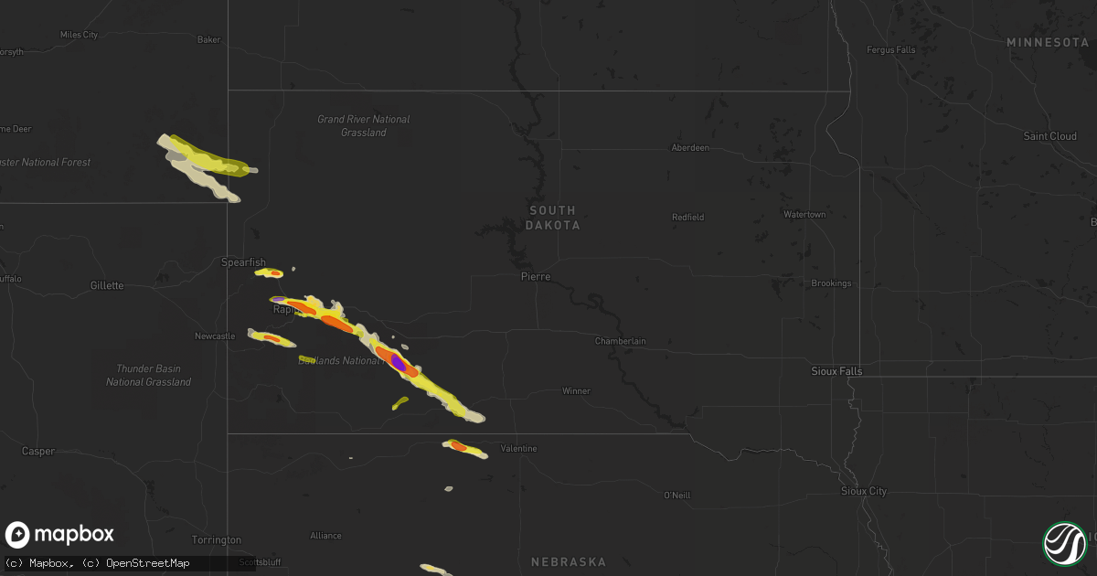
Hail Map in South Dakota on May 3, 2020
Get this storm
May 3 map
$229
one time, instant access
Download today. No call, no setup
Keep the $229
Bought the map and want the full workflow? Apply the entire $229 to a subscription within 7 days. None of it is wasted.
Every map, not just this one
This buys you this map. Subscription and you get every map we run, in the markets you choose from a few cities to whole states to nationwide. Plus real-time alerts the moment a storm fires.
Contact data
Name, contact info, occupancy, even credit band for addresses in the footprint. You go from where it hit to who to call.
Become the source they trust
Unlimited branding weather history reports on demand. You already have the documented answer ready for the property owner, and you are the one who showed up with it.
Property data and RoofTrace estimates
Pull up any address you have got, its value and the exact code rules for that jurisdiction, straight from One Click Code. Then RoofTrace estimates the squares, pitch, and roof value, priced the way you price.
Storm reports in South Dakota
South Dakota
| Date | Description |
|---|---|
| 05/03/20206:02 PM CDT | A local report indicates 1.75 inch wind near 4 NE FARMINGDALE |
| 05/03/20206:00 PM CDT | A local report indicates 1.00 inch wind near 3 SSE DWTN RAPID CITY |
| 05/03/20205:25 PM CDT | A local report indicates 1.50 inch wind near 4 WNW RAPID CITY ARPT |
| 05/03/20205:19 PM CDT | Delayed report... Uncertain duration... Time estimated from radar |
| 05/03/20205:07 PM CDT | North haines fire department |
| 05/03/20205:06 PM CDT | Up to ping pong ball size hail |
| 05/03/20205:02 PM CDT | A local report indicates 1.50 inch wind near 3 E BLACK HAWK |
| 05/03/20205:00 PM CDT | A local report indicates 1.25 inch wind near 4 E BLACK HAWK |
| 05/03/20205:00 PM CDT | A local report indicates 1.00 inch wind near 4 N DWTN RAPID CITY |
| 05/03/20204:54 PM CDT | A local report indicates 1.00 inch wind near 4 E BLACK HAWK |
| 05/03/20204:38 PM CDT | A local report indicates 1.00 inch wind near BLACK HAWK |
| 05/03/20204:36 PM CDT | A local report indicates 1.75 inch wind near STURGIS |
| 05/03/20204:31 PM CDT | A local report indicates 1.00 inch wind near STURGIS |
| 05/03/20204:20 PM CDT | A local report indicates 1.00 inch wind near STURGIS |
| 05/03/20204:18 PM CDT | Mostly pea to marble size hail. A few up to quarter size |
| 05/03/20204:10 PM CDT | Mostly peas... But lots of it |
| 05/03/20203:50 PM CDT | A local report indicates 1.25 inch wind near 3 ENE DEADWOOD |
| 05/03/20203:44 AM CDT | At 844 PM MDT/944 PM CDT/, a severe thunderstorm was located over Vetal, or 20 miles east of Martin, moving southeast at 30 mph. HAZARD...60 mph wind gusts and half dollar size hail. SOURCE...Radar indicated. IMPACT...Hail damage to vehicles is expected. Expect wind damage to roofs, siding, and trees. This severe thunderstorm will be near... Harrington around 855 PM MDT. |
| 05/03/20202:57 AM CDT | At 757 PM MDT/857 PM CDT/, a severe thunderstorm was located 4 miles southeast of Eagle Nest Butte, or 18 miles north of Martin, moving east at 25 mph. HAZARD...60 mph wind gusts and half dollar size hail. SOURCE...Radar indicated. IMPACT...Hail damage to vehicles is expected. Expect wind damage to roofs, siding, and trees. This severe thunderstorm will be near... Long Valley around 805 PM MDT. |
| 05/03/20202:05 AM CDT | At 705 PM MDT, a severe thunderstorm was located 4 miles northeast of Potato Creek, or 27 miles southwest of Kadoka, moving southeast at 30 mph. HAZARD...70 mph wind gusts and half dollar size hail. SOURCE...Radar indicated. IMPACT...Hail damage to vehicles is expected. Expect considerable tree damage. Wind damage is also likely to mobile homes, roofs, and outbuildings. This severe thunderstorm will be near... Snake Butte around 720 PM MDT. Hisle and Eagle Nest Butte around 735 PM MDT. |
| 05/03/20201:44 AM CDT | At 643 PM MDT, a severe thunderstorm was located over northeastern Custer State Park, or 9 miles east of Custer, moving east at 30 mph. HAZARD...Golf ball size hail and 60 mph wind gusts. SOURCE...Radar indicated. IMPACT...People and animals outdoors will be injured. Expect hail damage to roofs, siding, windows, and vehicles. Expect wind damage to roofs, siding, and trees. This severe thunderstorm will be near... Hermosa around 700 PM MDT. Fairburn around 710 PM MDT. |
| 05/03/20201:14 AM CDT | At 614 PM MDT, a severe thunderstorm was located 8 miles east of Badlands National Park, or 38 miles southwest of Philip, moving southeast at 25 mph. HAZARD...60 mph wind gusts and quarter size hail. SOURCE...Radar indicated. IMPACT...Hail damage to vehicles is expected. Expect wind damage to roofs, siding, and trees. This severe thunderstorm will be near... Interior and Cedar Pass around 655 PM MDT. Potato Creek around 710 PM MDT.This includes Interstate 90 in South Dakota between Mile Markers 127and 134. |
| 05/03/20201:07 AM CDT | At 606 PM MDT, a severe thunderstorm was located 3 miles west of Bear Mountain Lookout, or 11 miles west of Hill City, moving southeast at 25 mph. HAZARD...Quarter size hail. SOURCE...Radar indicated. IMPACT...Damage to vehicles is expected. This severe thunderstorm will be near... Bear Mountain Lookout and Medicine Mountain around 615 PM MDT. Hill City and Crazy Horse Memorial around 630 PM MDT. Northwestern Custer State Park, Sylvan Lake, Black Elk Peak and Palmer Gulch Resort around 635 PM MDT. Custer and Horse Thief Lake around 640 PM MDT. Stockade Lake, Legion Lake, Mount Coolidge, Center Lake, Black Hills Playhouse and Mount Rushmore National Memorial around 645 PM MDT. |
| 05/03/202012:19 AM CDT | At 519 PM MDT, a severe thunderstorm was located 6 miles east of Osage, or 10 miles northwest of Newcastle, moving southeast at 25 mph. HAZARD...Ping pong ball size hail and 60 mph wind gusts. SOURCE...Radar indicated. IMPACT...People and animals outdoors will be injured. Expect hail damage to roofs, siding, windows, and vehicles. Expect wind damage to roofs, siding, and trees. This severe thunderstorm will be near... Moon and Redbank Spring Campground around 550 PM MDT. |
| 05/03/202012:16 AM CDT | At 516 PM CDT/416 PM MDT/, a severe thunderstorm was located near Cody, or 27 miles southeast of Martin, moving east at 15 mph. HAZARD...60 mph wind gusts and quarter size hail. SOURCE...Radar indicated. IMPACT...Hail damage to vehicles is expected. Expect wind damage to roofs, siding, and trees. This severe thunderstorm will be near... Cody around 425 PM MDT. Nenzel around 455 PM MDT. Kilgore around 500 PM MDT.Other locations impacted by this severe thunderstorm include CodyLake.This includes Highway 20 between mile markers 150 and 176. |
| 05/03/202012:15 AM CDT | At 515 PM MDT, severe thunderstorms were located along a line extending from 6 miles northwest of Owanka to 9 miles east of Farmingdale to 3 miles northeast of Railroad Buttes, moving southeast at 35 mph. HAZARD...60 mph wind gusts and half dollar size hail. SOURCE...Radar indicated. IMPACT...Hail damage to vehicles is expected. Expect wind damage to roofs, siding, and trees. Severe thunderstorms will be near... Owanka and Wicksville around 525 PM MDT. Wasta around 535 PM MDT. Scenic and Sheep Mountain Table around 545 PM MDT. Northern Badlands National Park around 550 PM MDT. Pinnacles Ranger Station around 605 PM MDT.This includes Interstate 90 in South Dakota between Mile Markers 81and 119. |
| 05/03/202012:04 AM CDT | At 504 PM MDT, a severe thunderstorm was located near Rapid Valley, or 4 miles southeast of Rapid City, moving east at 20 mph. HAZARD...Quarter size hail. SOURCE...Radar indicated. IMPACT...Damage to vehicles is expected. This severe thunderstorm will be near... Rapid City Airport around 520 PM MDT. Caputa around 535 PM MDT. Thompson Butte around 540 PM MDT. |
| 05/02/202011:46 PM CDT | At 446 PM MDT, a severe thunderstorm was located 6 miles northwest of Swett, or 16 miles west of Martin, moving northeast at 25 mph. HAZARD...Quarter size hail. SOURCE...Radar indicated. IMPACT...Damage to vehicles is expected. This severe thunderstorm will be near... Allen around 500 PM MDT. Snake Butte around 525 PM MDT. Hisle around 530 PM MDT. |
| 05/02/202011:14 PM CDT | At 414 PM MDT, a severe thunderstorm was located over northern Rapid Valley, or 5 miles east of Rapid City, moving east at 15 mph. HAZARD...Ping pong ball size hail and 60 mph wind gusts. SOURCE...Radar indicated. IMPACT...People and animals outdoors will be injured. Expect hail damage to roofs, siding, windows, and vehicles. Expect wind damage to roofs, siding, and trees. This severe thunderstorm will be near... Box Elder around 420 PM MDT. Rapid City Airport around 430 PM MDT. Caputa around 450 PM MDT. New Underwood and Farmingdale around 505 PM MDT.This includes Interstate 90 in South Dakota between Mile Markers 61and 88. |
| 05/02/202010:37 PM CDT | At 336 PM MDT, a severe thunderstorm was located over Black Hawk, or 5 miles northwest of Rapid City, moving east at 15 mph. HAZARD...Ping pong ball size hail and 60 mph wind gusts. SOURCE...Radar indicated. IMPACT...People and animals outdoors will be injured. Expect hail damage to roofs, siding, windows, and vehicles. Expect wind damage to roofs, siding, and trees. This severe thunderstorm will be near... Rapid City around 350 PM MDT. Rapid Valley and Ellsworth Air Force Base around 410 PM MDT. Box Elder around 420 PM MDT.This includes Interstate 90 in South Dakota between Mile Markers 51and 67. |
| 05/02/202010:30 PM CDT | At 330 PM MDT, a severe thunderstorm was located over Fort Meade, or 3 miles southeast of Sturgis, moving east at 15 mph. HAZARD...60 mph wind gusts and half dollar size hail. SOURCE...Radar indicated. IMPACT...Hail damage to vehicles is expected. Expect wind damage to roofs, siding, and trees. Hail may accumulate on roadways causing hazardous travel. This severe thunderstorm will be near... Tilford around 340 PM MDT.This includes Interstate 90 in South Dakota between Mile Markers 30and 41. |
| 05/02/202010:05 PM CDT | At 305 PM MDT, a severe thunderstorm was located 3 miles southeast of Nemo, or 12 miles northwest of Rapid City, moving east at 10 mph. HAZARD...Ping pong ball size hail and 60 mph wind gusts. SOURCE...Radar indicated. IMPACT...People and animals outdoors will be injured. Expect hail damage to roofs, siding, windows, and vehicles. Expect wind damage to roofs, siding, and trees. This severe thunderstorm will be near... Summerset and Johnson Siding around 320 PM MDT. Black Hawk around 345 PM MDT.This includes Interstate 90 in South Dakota between Mile Markers 50and 53. |
| 05/02/20209:45 PM CDT | At 244 PM MDT, a severe thunderstorm was located near Apple Springs, or 6 miles northeast of Lead, moving southeast at 25 mph. HAZARD...60 mph wind gusts and quarter size hail. SOURCE...Radar indicated. IMPACT...Hail damage to vehicles is expected. Expect wind damage to roofs, siding, and trees. This severe thunderstorm will be near... Galena and Apple Springs around 250 PM MDT. Sturgis around 255 PM MDT. Fort Meade around 305 PM MDT. Tilford and Dalton Lake around 315 PM MDT.This includes Interstate 90 in South Dakota between Mile Markers 26and 44. |
| 05/02/20209:13 PM CDT | Ground is white |
| 05/02/20208:53 PM CDT | Over an inch of rain |
| 05/02/20208:34 PM CDT | A local report indicates 1.25 inch wind near 8 WSW WANBLEE |
| 05/02/20208:05 PM CDT | A local report indicates 2.75 inch wind near 5 NNE POTATO CREEK |
| 05/02/20208:00 PM CDT | Delayed report |
| 05/02/20207:40 PM CDT | Ground covered with dime to quarter size hail |
| 05/02/20207:32 PM CDT | A local report indicates 1.00 inch wind near 4 S HILL CITY |
| 05/02/20207:00 PM CDT | A local report indicates 1.00 inch wind near 8 NE SCENIC |
All States Impacted by Hail Map on May 3, 2020
Cities Impacted by Hail Map on May 3, 2020
- Wray, CO
- Eckley, CO
- Haigler, NE
- Westport, TN
- Osceola, AR
- Valley Springs, AR
- Pyatt, AR
- Harrison, AR
- Summit, AR
- Melbourne, AR
- Flippin, AR
- Norfork, AR
- Theodosia, MO
- Calico Rock, AR
- Lead Hill, AR
- Protem, MO
- Yellville, AR
- Rueter, MO
- Peel, AR
- Ravenden, AR
- Ravenden Springs, AR
- Somerville, TN
- Chapman, KS
- Enterprise, KS
- Solomon, KS
- Abilene, KS
- Sturgis, SD
- Mayfield, KY
- Clinton, KY
- Kirksey, KY
- Almo, KY
- Murray, KY
- Wingo, KY
- Fulton, KY
- Sedalia, KY
- Farmington, KY
- Limon, CO
- Elbert, CO
- Sterling, CO
- Merino, CO
- Toronto, KS
- Virgil, KS
- Yates Center, KS
- Bronte, TX
- Gypsum, KS
- Big Springs, NE
- Chappell, NE
- Bon Aqua, TN
- Dickson, TN
- Mount Juliet, TN
- Madison, TN
- Old Hickory, TN
- Hermitage, TN
- Nashville, TN
- Upton, WY
- Fremont, MO
- Birch Tree, MO
- Van Buren, MO
- Grandin, MO
- Eminence, MO
- Winona, MO
- Poplar Bluff, MO
- Ellsinore, MO
- Kilgore, NE
- Cody, NE
- Nenzel, NE
- Galesburg, KS
- West Plains, MO
- Purcell, MO
- Jasper, MO
- Carthage, MO
- Alba, MO
- Oronogo, MO
- Webb City, MO
- Atwood, KS
- McDonald, KS
- Henderson, TN
- Luray, TN
- Jacks Creek, TN
- Beech Bluff, TN
- Pinson, TN
- Jackson, TN
- Vernon, CO
- Yuma, CO
- Kimberling City, MO
- Shell Knob, MO
- Lampe, MO
- Blue Eye, MO
- Branson, MO
- Reeds Spring, MO
- Kirbyville, MO
- Ridgedale, MO
- Hollister, MO
- Fort Scott, KS
- Fulton, KS
- Reeds, MO
- Stotts City, MO
- Avilla, MO
- Sarcoxie, MO
- La Russell, MO
- Walnut Ridge, AR
- Lebanon, TN
- Castalian Springs, TN
- Gallatin, TN
- Marathon, TX
- Akron, CO
- Stanton, TN
- Brownsville, TN
- Henning, TN
- Blytheville, AR
- Atoka, TN
- Luxora, AR
- Brighton, TN
- Covington, TN
- Mason, TN
- Ripley, TN
- Burlison, TN
- Gill, CO
- Fredonia, KS
- Scammon, KS
- McCune, KS
- West Mineral, KS
- Mindenmines, MO
- Arma, KS
- Frontenac, KS
- Pittsburg, KS
- Weir, KS
- Asbury, MO
- Girard, KS
- Cherokee, KS
- Franklin, KS
- Greensburg, KY
- Cottontown, TN
- Portland, TN
- White House, TN
- Dyersburg, TN
- Huntingdon, TN
- Atwood, TN
- Wanblee, SD
- Elsie, NE
- Julesburg, CO
- Grant, NE
- Wauneta, NE
- Madrid, NE
- Hayes Center, NE
- Venango, NE
- Imperial, NE
- Dyer, TN
- Buffalo, SD
- Colby, KS
- Batavia, OH
- Smithville, AR
- Wiggins, CO
- Brush, CO
- Delaplaine, AR
- Mertzon, TX
- Hamilton, KS
- East Prairie, MO
- Parks, NE
- Holcomb, MO
- Carlsbad, TX
- Robert Lee, TX
- Black Hawk, SD
- Piedmont, SD
- Kyle, SD
- Long Valley, SD
- Box Elder, SD
- Saint Francis, SD
- Deadwood, SD
- Tuthill, SD
- Martin, SD
- Interior, SD
- Rapid City, SD
- Ellsworth Afb, SD
- New Underwood, SD
- Norris, SD
- Wall, SD
- Scenic, SD
- Caputa, SD
- Flagler, CO
- Hugo, CO
- Seibert, CO
- Simla, CO
- Genoa, CO
- Arriba, CO
- Matheson, CO
- Waverly, TN
- Ogallala, NE
- Ramah, CO
- Calhan, CO
- Martin, TN
- Oakfield, TN
- Broseley, MO
- Denmark, TN
- West Liberty, KY
- Jonesboro, AR
- Lake City, AR
- Bay, AR
- Jordan, MT
- Fort Meade, SD
- Whitewood, SD
- Troy, TN
- Rives, TN
- Hornbeak, TN
- Ridgely, TN
- Obion, TN
- Wellington, KS
- Dudley, MO
- Wappapello, MO
- Williamsville, MO
- Puxico, MO
- Fisk, MO
- Jerico Springs, MO
- Latham, KS
- Dora, MO
- Omaha, AR
- Goodlettsville, TN
- Hendersonville, TN
- Kanorado, KS
- Bethune, CO
- Stratton, CO
- Burlington, CO
- Aurora, MO
- Lobelville, TN
- Hurricane Mills, TN
- Woodrow, CO
- Humboldt, TN
- Alamo, TN
- Gadsden, TN
- Medina, TN
- Friendship, TN
- Lexington, TN
- Blackwell, TX
- Lawrenceburg, IN
- Harrison, OH
- North Bend, OH
- Doniphan, MO
- Pocahontas, AR
- Imboden, AR
- Summersville, MO
- Russell, KS
- Dorrance, KS
- Bunker Hill, KS
- Hartville, MO
- Marshfield, MO
- Niangua, MO
- Stoneham, CO
- Caulfield, MO
- Miller, MO
- Rector, AR
- Boyes, MT
- Willow Springs, MO
- Crane, MO
- Fleming, CO
- Atwood, CO
- Goodland, KS
- Whites Creek, TN
- Whiteville, TN
- Orchard, CO
- Alzada, MT
- Briggsdale, CO
- Fort Morgan, CO
- Salina, KS
- Benedict, KS
- Chanute, KS
- Belle Fourche, SD
- Hammond, MT
- Lemoyne, NE
- Lewellen, NE
- Essex, MO
- Agate, CO
- Decker, MT
- Wingate, TX
- Tuscola, TX
- Worden, MT
- Keystone, NE
- Paxton, NE
- Humboldt, KS
- Buffalo, KS
- Madison, KS
- Eureka, KS
- Piqua, KS
- Erie, KS
- Sylvan Grove, KS
- Wilson, KS
- Buena Vista, TN
- Abilene, TX
- Merkel, TX
- Keystone, SD
- Hill City, SD
- Custer, SD
- Hermosa, SD
- Columbus, KY
- Matthews, MO
- Ash Grove, MO
- Bois D Arc, MO
- Champion, NE
- Joelton, TN
- Whitman, NE
- Hyannis, NE
- Neck City, MO
- De Mossville, KY
- Butler, KY
- Highlandville, MO
- Galena, MO
- Clever, MO
- Billings, MO
- Walnut Grove, MO
- Aldrich, MO
- Morrisville, MO
- Bolivar, MO
- Lance Creek, WY
- Cabool, MO
- Snyder, CO
- Max, NE
- Benkelman, NE
- Cherryvale, KS
- Neodesha, KS
- Elk City, KS
- Independence, KS
- Republican City, NE
- Springfield, MO
- Willard, MO
- Fancy Farm, KY
- Dexter, KY
- Cincinnati, OH
- Osage City, KS
- Saint Paul, KS
- Walnut, KS
- Trenton, TN
- Maynard, AR
- Corning, AR
- Biggers, AR
- Ballinger, TX
- Winters, TX
- Danforth, ME
- Moundville, MO
- Uniontown, KS
- Arcadia, KS
- Garland, KS
- Bronaugh, MO
- Buffalo Gap, TX
- Volborg, MT
- Monett, MO
- Marionville, MO
- Columbus, KS
- Pierce City, MO
- Carl Junction, MO
- Nixa, MO
- Ozark, MO
- Golden City, MO
- Freistatt, MO
- Galena, KS
- Mount Vernon, MO
- Verona, MO
- Wentworth, MO
- Tiptonville, TN
- Pontiac, MO
- Midway, AR
- Everton, AR
- Cape Fair, MO
- Cotter, AR
- Cedarcreek, MO
- Oxford, AR
- Brockwell, AR
- Viola, AR
- Pineville, AR
- Elizabeth, AR
- Salem, AR
- Gassville, AR
- Golden, MO
- Oakland, AR
- Sage, AR
- Franklin, AR
- Wideman, AR
- Dolph, AR
- Bexar, AR
- Mountain Home, AR
- Lakeview, AR
- Cassville, MO
- Bull Shoals, AR
- Altamont, KS
- Parsons, KS
- Pottersville, MO
- Otter, MT
- Norman, IN
- Liberal, MO
- Paragould, AR
- Cumberland Furnace, TN
- Vanleer, TN
- Weldona, CO
- Cheyenne, WY
- Allen, SD
- Byers, CO
- Ashland City, TN
- Sikeston, MO
- Bloomfield, MO
- Dexter, MO
- Forsyth, MO
- Rockaway Beach, MO
- Taneyville, MO
- Longton, KS
- Otis, CO
- Heltonville, IN
- Bedford, IN
- Vona, CO
- Fordland, MO
- Seymour, MO
- Broadwater, NE
- Brownstown, IN
- Medora, IN
- Redfield, KS
- Severy, KS
- Fall River, KS
- Gates, TN
- Howard, KS
- Knobel, AR
- Warm Springs, AR
- Peach Orchard, AR
- Success, AR
- Purdy, MO
- Salyersville, KY
- Wiseman, AR
- Glencoe, AR
- Ash Flat, AR
- Horseshoe Bend, AR
- Arthur, NE
- Tryon, NE
- Colony, KS
- Westphalia, KS
- McKee, KY
- Mount Vernon, KY
- Berea, KY
- Charlotte, TN
- Moody, MO
- Tecumseh, MO
- Beaver City, NE
- Mountain View, MO
- Nunnelly, TN
- Only, TN
- Lyles, TN
- Duck River, TN
- Centerville, TN
- Bradford, TN
- Piedmont, KS
- Beaumont, KS
- Leon, KS
- Iola, KS
- Union City, TN
- Hay Springs, NE
- Blue Mound, KS
- Mapleton, KS
- Mound City, KS
- Lancaster, KY
- Datto, AR
- Greenfield, MO
- Alicia, AR
- Portia, AR
- Hoxie, AR
- Wildersville, TN
- Darden, TN
- Commiskey, IN
- Hartsville, TN
- Linden, TN
- Denniston, KY
- Wellington, KY
- Ezel, KY
- Frenchburg, KY
- Salt Lick, KY
- Gepp, AR
- Medon, TN
- Mercer, TN
- Grover, CO
- Chadwick, MO
- Chestnutridge, MO
- Ponce De Leon, MO
- Lockwood, MO
- Sparta, MO
- South Greenfield, MO
- Everton, MO
- Republic, MO
- Oldfield, MO
- Spokane, MO
- Cedar Grove, TN
- Clifton, TN
- Madison, IN
- Florence, IN
- Bennington, IN
- Vevay, IN
- Stratton, NE
- Winchester, OH
- Brentwood, TN
- Mount Orab, OH
- Sardinia, OH
- Oswego, KS
- Cottage Grove, TN
- Paris, TN
- Erin, TN
- Holladay, TN
- Ovalo, TX
- Lawn, TX
- Huron, TN
- Reagan, TN
- Newcastle, WY
- Trenton, NE
- Talpa, TX
- Oberlin, KS
- Herndon, KS
- Kenton, TN
- Broadus, MT
- Cadiz, KY
- Mount Sterling, KY
- Orleans, NE
- Alma, NE
- Camden, TN
- Brule, NE
- Exeter, MO
- Norwood, MO
- Big Lake, TX
- Mound Valley, KS
- Sidney, AR
- Verona, KY
- Warsaw, KY
- Deputy, IN
- Paris Crossing, IN
- Piggott, AR
- Saint Francis, AR
- Campbell, MO
- Rogersville, MO
- Haxtun, CO
- Sedgwick, CO
- Bells, TN
- Halls, TN
- Milan, TN
- Water Valley, KY
- Keenesburg, CO
- Springfield, TN
- Chapmansboro, TN
- Cedar Hill, TN
- Pleasant View, TN
- Brookland, AR
- Sturkie, AR
- Thornfield, MO
- New Concord, KY
- Clyde, TX
- Oxly, MO
- Naylor, MO
- Leachville, AR
- Monette, AR
- Dell, AR
- Manila, AR
- Pleasanton, KS
- Bruner, MO
- Clarksville, TN
- Sunman, IN
- Milan, IN
- Deer Trail, CO
- Greeley, CO
- Hardy, AR
- Etowah, AR
- Lavinia, TN
- Duenweg, MO
- Diamond, MO
- Joplin, MO
- Black Oak, AR
- Caraway, AR
- Mammoth Spring, AR
- Scotts Hill, TN
- Sardis, TN
- Portageville, MO
- Greenfield, TN
- Rutherford, TN
- Parsons, TN
- Decaturville, TN
- Trezevant, TN
- Finley, TN
- Lincoln, KS
- Bolivar, TN
- Toone, TN
- La Harpe, KS
- Moran, KS
- Cherokee Village, AR
- Richmond, KY
- Irvine, KY
- Guilford, IN
- Stanton, KY
- Cardwell, MO
- Arbyrd, MO
- Houston, MO
- Elk Creek, MO
- Solo, MO
- Graff, MO
- Mountain Grove, MO
- Hillrose, CO
- Gainesville, MO
- Roggen, CO
- Nevada, MO
- Bono, AR
- Palmersville, TN
- Burns, TN
- Clay City, KY
- Wilson, AR
- Catron, MO
- Hickman, KY
- Bertrand, MO
- Charleston, MO
- Arlington, KY
- New Madrid, MO
- Bethpage, TN
- Westmoreland, TN
- State University, AR
- Smiths Grove, KY
- Henry, TN
- Coffeyville, KS
- Bartlett, KS
- Atlanta, KS
- Liberty, KS
- Augusta, KS
- Edna, KS
- Eubank, KY
- Waynesburg, KY
- Franklin, TN
- Hayti, MO
- Bragg City, MO
- Wardell, MO
- Devils Tower, WY
- Hazel, KY
- Buchanan, TN
- Wytopitlock, ME
- Poughkeepsie, AR
- Cave City, AR
- Powersite, MO
- Evening Shade, AR
- Mount Pleasant, AR
- Gamaliel, AR
- Bradleyville, MO
- Dyess, AR
- Pall Mall, TN
- Jamestown, TN
- Bird City, KS
- Williamsburg, OH
- Dadeville, MO
- Middleburg, KY
- Kings Mountain, KY
- Paint Lick, KY
- Stanford, KY
- Crab Orchard, KY
- Kincaid, KS
- Welda, KS
- Springville, IN
- Mize, KY
- Liberty, KY
- Arlington, TN
- Black Rock, AR
- Powhatan, AR
- Seymour, IN
- Neosho Falls, KS
- Gridley, KS
- Ellsworth, KS
- Elizabeth, CO
- Oshkosh, NE
- Lodgepole, NE
- Sidney, NE
- Bronson, KS
- Hartsville, IN
- Columbus, IN
- Beech Grove, AR
- Merom, IN
- Carlisle, IN
- Greenbrier, TN
- Marmaduke, AR
- Means, KY
- Jeffersonville, KY
- Nemo, SD
- Fairburn, SD
- Capitol, MT
- Wibaux, MT
- Sentinel Butte, ND
- Beach, ND
- Kissee Mills, MO
- Brighton, MO
- Harbeson, DE
- Rehoboth Beach, DE
- Millsboro, DE
- Lewes, DE
- Lamar, MO
- Arcola, MO
- Stockton, MO
- Walnut Shade, MO
- Shelbyville, TN
- Gleason, TN
- Hickman, TN
- Carthage, TN
- Hilham, TN
- Whitleyville, TN
- Hampshire, TN
- Auburntown, TN
- Woodbury, TN
- Clarkton, MO
- Manchester, TN
- Pollard, AR
- Macomb, MO
- Buffalo Valley, TN
- Mount Pleasant, TN
- Morrison, TN
- Culleoka, TN
- Beechgrove, TN
- Brandsville, MO
- Mill Spring, MO
- Southside, TN
- Smithville, TN
- Indian Mound, TN
- Readyville, TN
- Big Sandy, TN
- Rickman, TN
- Bardwell, KY
- Steele, MO
- Granville, TN
- Zalma, MO
- College Grove, TN
- Lewisburg, TN
- Normandy, TN
- Watertown, TN
- Squires, MO
- Sharon, TN
- Fairview, TN
- Cumberland City, TN
- Qulin, MO
- Greenville, MO
- Lascassas, TN
- Primm Springs, TN
- Kennett, MO
- Williamsport, TN
- Pomona, MO
- Spencer, TN
- Hohenwald, TN
- Lafayette, TN
- Bernie, MO
- Neelyville, MO
- Sugar Tree, TN
- La Vergne, TN
- Couch, MO
- Newbern, TN
- Fairdealing, MO
- Stewart, TN
- Kingston Springs, TN
- Doyle, TN
- Gordonsville, TN
- Chapel Hill, TN
- Spring Hill, TN
- Milton, TN
- Alexandria, TN
- Eva, TN
- McKenzie, TN
- Murfreesboro, TN
- Smyrna, TN
- Bradyville, TN
- Columbia, TN
- Bell City, MO
- Drury, MO
- Walling, TN
- Silver Point, TN
- Gideon, MO
- Cookeville, TN
- Antioch, TN
- Moss, TN
- Palmyra, TN
- Sturdivant, MO
- Harviell, MO
- Elmwood, TN
- Celina, TN
- Koshkonong, MO
- Rockvale, TN
- Rock Island, TN
- Canalou, MO
- Bell Buckle, TN
- Quebeck, TN
- Hollow Rock, TN
- Pleasant Shade, TN
- Dover, TN
- Dowelltown, TN
- Parma, MO
- Yuma, TN
- Mcminnville, TN
- Oran, MO
- Bloomington Springs, TN
- Trimble, TN
- Baxter, TN
- Wartrace, TN
- Woodlawn, TN
- Mansfield, MO
- Advance, MO
- Gibson, MO
- McGee, MO
- Christiana, TN
- Vanzant, MO
- Malden, MO
- Greenway, AR
- Liberty, TN
- Lancaster, TN
- Brush Creek, TN
- Puryear, TN
- Livingston, TN
- Thayer, MO
- White Bluff, TN
- McEwen, TN
- Peace Valley, MO
- Springville, TN
- Arrington, TN
- Allons, TN
- Thompsons Station, TN
- Riddleton, TN
- Gainesboro, TN
- Alton, MO
- Pegram, TN
- Eagleville, TN
- Dukedom, TN
- Dresden, TN
- Caruthersville, MO
- Nolensville, TN
- Bruceton, TN
- Lilbourn, MO
- Santa Fe, TN
- Dixon Springs, TN
- Marston, MO
- South Fulton, TN
- Unionville, TN
- Ava, MO
- Piedmont, MO
- Tennessee Ridge, TN
- Sparta, TN
- Chestnut Mound, TN
- Cunningham, TN
- Vanduser, MO
- Red Boiling Springs, TN
- Anniston, MO
- New Johnsonville, TN
- Mansfield, TN
- Lynn, AR
- Williford, AR
- Weiner, AR
- O'Kean, AR
- Violet Hill, AR
- Lafe, AR
- Cash, AR
- Hornersville, MO
- Trumann, AR
- Keiser, AR
- Swifton, AR
- Marked Tree, AR
- Lepanto, AR
- Harrisburg, AR
- Lookout Mountain, GA
- Flintville, TN
- Ardmore, TN
- Killen, AL
- Toney, AL
- Elkmont, AL
- Ringgold, GA
- Rock Spring, GA
- Stevenson, AL
- Menlo, GA
- Waterloo, AL
- Tunnel Hill, GA
- Lester, AL
- Higdon, AL
- Huntland, TN
- Hollywood, AL
- New Market, AL
- Fackler, AL
- Ider, AL
- La Fayette, GA
- Rogersville, AL
- Anderson, AL
- Rocky Face, GA
- Meridianville, AL
- Rossville, GA
- Estillfork, AL
- Chickamauga, GA
- Trenton, GA
- Saint Joseph, TN
- Minor Hill, TN
- Kelso, TN
- Wildwood, GA
- Fort Oglethorpe, GA
- Flat Rock, AL
- Elora, TN
- Five Points, TN
- Fayetteville, TN
- Hazel Green, AL
- Bryant, AL
- Taft, TN
- Pisgah, AL
- Florence, AL
- Prospect, TN
- Scottsboro, AL
- Trion, GA
- Cypress Inn, TN
- Bridgeport, AL
- Rising Fawn, GA
- Ardmore, AL
- Loretto, TN
- Lutts, TN
- Iron City, TN
- Flintstone, GA
- Athens, AL
- Lexington, AL
- King George, VA
- Elsmore, KS
- Chetopa, KS
- Iliff, CO
- Kiowa, CO
- Bennett, CO


