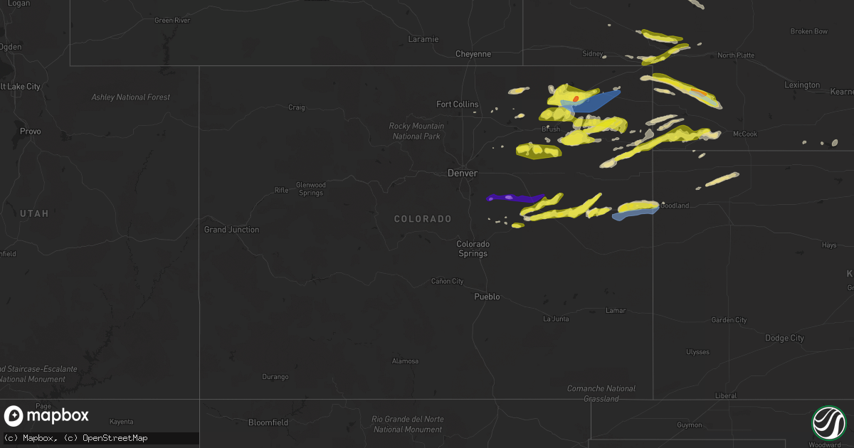
Hail Map in Colorado on May 3, 2020
Get this storm
May 3 map
$229
one time, instant access
Download today. No call, no setup
Keep the $229
Bought the map and want the full workflow? Apply the entire $229 to a subscription within 7 days. None of it is wasted.
Every map, not just this one
This buys you this map. Subscription and you get every map we run, in the markets you choose from a few cities to whole states to nationwide. Plus real-time alerts the moment a storm fires.
Contact data
Name, contact info, occupancy, even credit band for addresses in the footprint. You go from where it hit to who to call.
Become the source they trust
Unlimited branding weather history reports on demand. You already have the documented answer ready for the property owner, and you are the one who showed up with it.
Property data and RoofTrace estimates
Pull up any address you have got, its value and the exact code rules for that jurisdiction, straight from One Click Code. Then RoofTrace estimates the squares, pitch, and roof value, priced the way you price.
Storm reports in Colorado
Colorado
| Date | Description |
|---|---|
| 05/03/20206:50 AM CDT | At 1150 PM MDT, a severe thunderstorm was located near Hoyt, or 24 miles southwest of Fort Morgan, moving east at 35 mph. HAZARD...60 mph wind gusts and quarter size hail. SOURCE...Radar indicated. IMPACT...Expect damage to roofs, siding, and trees. Hail damage to vehicles is expected. Locations impacted include... Twelve-Mile Corner, Hoyt, Shamrock, Leader, Adena School and Adena. |
| 05/03/20206:48 AM CDT | At 1148 PM MDT, a severe thunderstorm was located over Prewitt Reservoir, or 16 miles southwest of Sterling, moving east at 35 mph. HAZARD...60 mph wind gusts and quarter size hail. SOURCE...Radar indicated. IMPACT...Expect damage to roofs, siding, and trees. Hail damage to vehicles is expected. Locations impacted include... Sterling, Merino, Logan Corners, Prewitt Reservoir and Atwood. |
| 05/03/20206:42 AM CDT | At 1142 PM MDT, a severe thunderstorm was located 14 miles northeast of Kiowa, or 32 miles northwest of Limon, moving east at 30 mph. HAZARD...Quarter size hail. SOURCE...Radar indicated. IMPACT...Damage to vehicles is expected. Locations impacted include... Deer Trail and Agate. |
| 05/03/20206:18 AM CDT | At 1118 PM MDT, a severe thunderstorm was located over Antelope Springs, or 12 miles north of Fort Morgan, moving east at 35 mph. HAZARD...60 mph wind gusts and half dollar size hail. SOURCE...Radar indicated. IMPACT...Expect damage to roofs, siding, and trees. Hail damage to vehicles is expected. Locations impacted include... Fort Morgan, Brush, Merino, Hillrose, Prewitt Reservoir, Antelope Springs, Stoneham, Snyder, Pawnee Pass and Willard. |
| 05/03/20206:17 AM CDT | At 1116 PM MDT, a severe thunderstorm was located near Kanorado, moving east at 35 mph. HAZARD...60 mph wind gusts and quarter size hail. SOURCE...Radar indicated. IMPACT...Hail damage to vehicles is expected. Expect wind damage to roofs, siding, and trees. Locations impacted include... Goodland, Kanorado, Ruleton and Edson. This includes Interstate 70 in Kansas between mile markers 0 and 35. |
| 05/03/20206:14 AM CDT | At 1114 PM MDT, a severe thunderstorm was located near Ponderosa Park, or 27 miles southeast of Denver, moving east at 30 mph. HAZARD...60 mph wind gusts and quarter size hail. SOURCE...Radar indicated. IMPACT...Expect damage to roofs, siding, and trees. Hail damage to vehicles is expected. Locations impacted include... Elizabeth, Kiowa and Ponderosa Park. |
| 05/03/20206:11 AM CDT | At 1110 PM MDT, a severe thunderstorm was located 10 miles west of St Petersburg, or 10 miles east of Sterling, moving east at 35 mph. HAZARD...60 mph wind gusts and quarter size hail. SOURCE...Radar indicated. IMPACT...Expect damage to roofs, siding, and trees. Hail damage to vehicles is expected. Locations impacted include... Southeastern Sterling, Fleming, Iliff, St Petersburg and Proctor. |
| 05/03/20205:58 AM CDT | At 1058 PM MDT, a severe thunderstorm was located near Burlington, moving east at 30 mph. HAZARD...60 mph wind gusts and quarter size hail. SOURCE...Radar indicated. IMPACT...Hail damage to vehicles is expected. Expect wind damage to roofs, siding, and trees. Locations impacted include... Burlington and Kanorado. This includes the following highways... Interstate 70 in Kansas between mile markers 0 and 5. Interstate 70 in Colorado between mile markers 436 and 450. Highway 385 between mile markers 186 and 205, and near mile marker211. |
| 05/03/20205:38 AM CDT | At 1037 PM MDT, a severe thunderstorm was located over Pawnee Pass, or 13 miles west of Sterling, moving east at 35 mph. HAZARD...60 mph wind gusts and quarter size hail. SOURCE...Radar indicated. IMPACT...Expect damage to roofs, siding, and trees. Hail damage to vehicles is expected. Locations impacted include... Sterling, Merino, Iliff, Padroni, Atwood, Logan Corners, North Sterling Reservoir, Pawnee Pass and Willard. |
| 05/03/20205:37 AM CDT | At 1036 PM MDT, a severe thunderstorm was located over Ramah, or 26 miles southwest of Limon, moving east at 25 mph. HAZARD...60 mph wind gusts and quarter size hail. SOURCE...Radar indicated. IMPACT...Expect damage to roofs, siding, and trees. Hail damage to vehicles is expected. Locations impacted include... Simla and Matheson. |
| 05/03/20205:31 AM CDT | At 1030 PM MDT, a severe thunderstorm was located over Ramah, or 28 miles southwest of Limon, moving east at 30 mph. HAZARD...60 mph wind gusts and quarter size hail. SOURCE...Radar indicated. IMPACT...Hail damage to vehicles is expected. Expect wind damage to roofs, siding, and trees. Locations impacted include... Ramah. |
| 05/03/20205:28 AM CDT | At 1028 PM MDT, a severe thunderstorm was located near Bethune, or 6 miles east of Stratton, moving east at 30 mph. HAZARD...60 mph wind gusts and quarter size hail. SOURCE...Radar indicated. IMPACT...Hail damage to vehicles is expected. Expect wind damage to roofs, siding, and trees. Locations impacted include... Burlington, Stratton and Bethune. This includes the following highways... Interstate 70 in Colorado between mile markers 420 and 450. Highway 385 between mile markers 186 and 205, and near mile marker211. |
| 05/03/20204:46 AM CDT | At 946 PM MDT, a severe thunderstorm was located 8 miles northwest of Limon, moving northeast at 25 mph. HAZARD...60 mph wind gusts and quarter size hail. SOURCE...Radar indicated. IMPACT...Expect damage to roofs, siding, and trees. Hail damage to vehicles is expected. Locations impacted include... Limon. |
| 05/03/20204:45 AM CDT | At 945 PM MDT, a severe thunderstorm was located over Seibert, moving east at 20 mph. HAZARD...60 mph wind gusts and quarter size hail. SOURCE...Radar indicated. IMPACT...Hail damage to vehicles is expected. Expect wind damage to roofs, siding, and trees. Locations impacted include... Stratton, Seibert and Vona. This includes Interstate 70 in Colorado between mile markers 399 and425. |
| 05/03/20204:32 AM CDT | At 931 PM MDT, a severe thunderstorm was located 11 miles southeast of Highland Center, or 16 miles southwest of Holyoke, moving east at 20 mph. HAZARD...60 mph wind gusts and quarter size hail. SOURCE...Radar indicated. IMPACT...Hail damage to vehicles is expected. Expect wind damage to roofs, siding, and trees. Locations impacted include... Wauneta.This includes Highway 385 between mile markers 258 and 269. |
| 05/03/20204:05 AM CDT | At 905 PM MDT, a severe thunderstorm was located over Arriba, or 9 miles west of Flagler, moving east at 25 mph. HAZARD...60 mph wind gusts and quarter size hail. SOURCE...Radar indicated. IMPACT...Hail damage to vehicles is expected. Expect wind damage to roofs, siding, and trees. Locations impacted include... Flagler and Seibert. This includes Interstate 70 in Colorado between mile markers 390 and408. |
| 05/03/20203:59 AM CDT | At 859 PM MDT, a severe thunderstorm was located 10 miles east of Lone Star, or 14 miles north of Yuma, moving east at 30 mph. HAZARD...60 mph wind gusts and quarter size hail. SOURCE...Radar indicated. IMPACT...Hail damage to vehicles is expected. Expect wind damage to roofs, siding, and trees. Locations impacted include... Clarkville.This includes Highway 385 between mile markers 266 and 269. |
| 05/03/20203:51 AM CDT | At 850 PM MDT, a severe thunderstorm was located 8 miles north of Matheson, or 14 miles west of Limon, moving northeast at 25 mph. HAZARD...Quarter size hail. SOURCE...Radar indicated. IMPACT...Damage to vehicles is expected. This severe thunderstorm will remain over mainly rural areas of east central Elbert County, which includes Cedar Point. |
| 05/03/20203:32 AM CDT | At 831 PM MDT, a severe thunderstorm was located 7 miles south of Lone Star, or 9 miles northwest of Yuma, moving east at 30 mph. HAZARD...60 mph wind gusts and quarter size hail. SOURCE...Radar indicated. IMPACT...Hail damage to vehicles is expected. Expect wind damage to roofs, siding, and trees. Locations impacted include... Clarkville. |
| 05/03/20203:32 AM CDT | At 831 PM MDT, a severe thunderstorm was located near Genoa, or 13 miles east of Limon, moving east at 30 mph. HAZARD...Ping pong ball size hail and 60 mph wind gusts. SOURCE...Radar indicated. IMPACT...Expect damage to roofs, siding, and trees. People and animals outdoors will be injured. Expect hail damage to roofs, siding, windows, and vehicles. Locations impacted include... Arriba and Genoa. |
| 05/03/20203:30 AM CDT | At 830 PM MDT, severe thunderstorms were located along a line extending from 7 miles west of Burdett to 7 miles east of Gary, or along a line extending from 16 miles south of Sterling to 13 miles southwest of Akron, moving east at 40 mph. HAZARD...60 mph wind gusts and quarter size hail. SOURCE...Radar indicated. IMPACT...Expect damage to roofs, siding, and trees. Hail damage to vehicles is expected. Locations impacted include... Akron, Otis, Lone Star, Platner and Burdett. |
| 05/03/20203:05 AM CDT | At 804 PM MDT, a severe thunderstorm was located 5 miles north of Platner, or 8 miles northeast of Akron, moving east at 35 mph. HAZARD...60 mph wind gusts and half dollar size hail. SOURCE...Radar indicated. IMPACT...Expect damage to roofs, siding, and trees. Hail damage to vehicles is expected. Locations impacted include... Lone Star. |
| 05/03/20202:47 AM CDT | At 747 PM MDT, a severe thunderstorm was located near Jackson Reservoir, or 20 miles northwest of Fort Morgan, moving east at 25 mph. HAZARD...Quarter size hail. SOURCE...Radar indicated. IMPACT...Damage to vehicles is expected. Locations impacted include... Jackson Reservoir. |
| 05/03/20202:42 AM CDT | At 741 PM MDT, a severe thunderstorm was located near Limon, moving east at 25 mph. HAZARD...Half dollar size hail. SOURCE...Radar indicated. IMPACT...Damage to vehicles is expected. Locations impacted include... Limon and Genoa. |
| 05/03/20202:33 AM CDT | At 732 PM MDT, a severe thunderstorm was located 14 miles northeast of Cope, or 18 miles south of Yuma, moving east at 30 mph. HAZARD...60 mph wind gusts and quarter size hail. SOURCE...Radar indicated. IMPACT...Hail damage to vehicles is expected. Expect wind damage to roofs, siding, and trees. Locations impacted include... Abarr, Heartstrong and Vernon. This includes Highway 385 between mile markers 219 and 229. |
| 05/03/20202:10 AM CDT | At 710 PM MDT, a severe thunderstorm was located near Matheson, or 14 miles southwest of Limon, moving east at 30 mph. HAZARD...60 mph wind gusts and quarter size hail. SOURCE...Radar indicated. IMPACT...Expect damage to roofs, siding, and trees. Hail damage to vehicles is expected. Locations impacted include... Limon and Matheson. |
| 05/03/20201:43 AM CDT | At 642 PM MDT, a severe thunderstorm was located 5 miles northwest of Fairfield, or 18 miles northwest of Holyoke, moving northeast at 25 mph. HAZARD...60 mph wind gusts and quarter size hail. SOURCE...Radar indicated. IMPACT...Expect damage to roofs, siding, and trees. Hail damage to vehicles is expected. Locations impacted include... Julesburg, Ovid, Sedgwick, Fairfield, Marks Butte and Sixteen-Mile Corner. |
| 05/03/202012:14 AM CDT | At 514 PM MDT, a severe thunderstorm was located 7 miles southwest of Eckley, or 9 miles southeast of Yuma, moving northeast at 45 mph. HAZARD...60 mph wind gusts and quarter size hail. SOURCE...Radar indicated. IMPACT...Hail damage to vehicles is expected. Expect wind damage to roofs, siding, and trees. Locations impacted include... Yuma, Wray, Eckley and Heartstrong. This includes Highway 385 between mile markers 238 and 252. |
| 05/02/202011:55 PM CDT | A local report indicates 1.75 inch wind near STERLING |
| 05/02/202011:38 PM CDT | A local report indicates 1.00 inch wind near 3 WSW PAWNEE PASS |
| 05/02/202010:46 PM CDT | A local report indicates 1.00 inch wind near 1 E CEDAR POINT |
| 05/02/202010:16 PM CDT | At 315 PM MDT, a severe thunderstorm was located 9 miles north of Venango, or 11 miles southeast of Julesburg, moving east at 25 mph. HAZARD...60 mph wind gusts and quarter size hail. SOURCE...Radar indicated. IMPACT...Hail damage to vehicles is expected. Expect wind damage to roofs, siding, and trees. Locations impacted include... Grant, Brandon and Wild Horse Spring. This includes Highway 61 between mile markers 59 and 83. |
| 05/02/20209:30 PM CDT | A local report indicates 1.00 inch wind near 6 SSW LONE STAR |
| 05/02/20208:34 PM CDT | A local report indicates 1.00 inch wind near 8 ENE MATHESON |
All States Impacted by Hail Map on May 3, 2020
Cities Impacted by Hail Map on May 3, 2020
- Wray, CO
- Eckley, CO
- Haigler, NE
- Westport, TN
- Osceola, AR
- Valley Springs, AR
- Pyatt, AR
- Harrison, AR
- Summit, AR
- Melbourne, AR
- Flippin, AR
- Norfork, AR
- Theodosia, MO
- Calico Rock, AR
- Lead Hill, AR
- Protem, MO
- Yellville, AR
- Rueter, MO
- Peel, AR
- Ravenden, AR
- Ravenden Springs, AR
- Somerville, TN
- Chapman, KS
- Enterprise, KS
- Solomon, KS
- Abilene, KS
- Sturgis, SD
- Mayfield, KY
- Clinton, KY
- Kirksey, KY
- Almo, KY
- Murray, KY
- Wingo, KY
- Fulton, KY
- Sedalia, KY
- Farmington, KY
- Limon, CO
- Elbert, CO
- Sterling, CO
- Merino, CO
- Toronto, KS
- Virgil, KS
- Yates Center, KS
- Bronte, TX
- Gypsum, KS
- Big Springs, NE
- Chappell, NE
- Bon Aqua, TN
- Dickson, TN
- Mount Juliet, TN
- Madison, TN
- Old Hickory, TN
- Hermitage, TN
- Nashville, TN
- Upton, WY
- Fremont, MO
- Birch Tree, MO
- Van Buren, MO
- Grandin, MO
- Eminence, MO
- Winona, MO
- Poplar Bluff, MO
- Ellsinore, MO
- Kilgore, NE
- Cody, NE
- Nenzel, NE
- Galesburg, KS
- West Plains, MO
- Purcell, MO
- Jasper, MO
- Carthage, MO
- Alba, MO
- Oronogo, MO
- Webb City, MO
- Atwood, KS
- McDonald, KS
- Henderson, TN
- Luray, TN
- Jacks Creek, TN
- Beech Bluff, TN
- Pinson, TN
- Jackson, TN
- Vernon, CO
- Yuma, CO
- Kimberling City, MO
- Shell Knob, MO
- Lampe, MO
- Blue Eye, MO
- Branson, MO
- Reeds Spring, MO
- Kirbyville, MO
- Ridgedale, MO
- Hollister, MO
- Fort Scott, KS
- Fulton, KS
- Reeds, MO
- Stotts City, MO
- Avilla, MO
- Sarcoxie, MO
- La Russell, MO
- Walnut Ridge, AR
- Lebanon, TN
- Castalian Springs, TN
- Gallatin, TN
- Marathon, TX
- Akron, CO
- Stanton, TN
- Brownsville, TN
- Henning, TN
- Blytheville, AR
- Atoka, TN
- Luxora, AR
- Brighton, TN
- Covington, TN
- Mason, TN
- Ripley, TN
- Burlison, TN
- Gill, CO
- Fredonia, KS
- Scammon, KS
- McCune, KS
- West Mineral, KS
- Mindenmines, MO
- Arma, KS
- Frontenac, KS
- Pittsburg, KS
- Weir, KS
- Asbury, MO
- Girard, KS
- Cherokee, KS
- Franklin, KS
- Greensburg, KY
- Cottontown, TN
- Portland, TN
- White House, TN
- Dyersburg, TN
- Huntingdon, TN
- Atwood, TN
- Wanblee, SD
- Elsie, NE
- Julesburg, CO
- Grant, NE
- Wauneta, NE
- Madrid, NE
- Hayes Center, NE
- Venango, NE
- Imperial, NE
- Dyer, TN
- Buffalo, SD
- Colby, KS
- Batavia, OH
- Smithville, AR
- Wiggins, CO
- Brush, CO
- Delaplaine, AR
- Mertzon, TX
- Hamilton, KS
- East Prairie, MO
- Parks, NE
- Holcomb, MO
- Carlsbad, TX
- Robert Lee, TX
- Black Hawk, SD
- Piedmont, SD
- Kyle, SD
- Long Valley, SD
- Box Elder, SD
- Saint Francis, SD
- Deadwood, SD
- Tuthill, SD
- Martin, SD
- Interior, SD
- Rapid City, SD
- Ellsworth Afb, SD
- New Underwood, SD
- Norris, SD
- Wall, SD
- Scenic, SD
- Caputa, SD
- Flagler, CO
- Hugo, CO
- Seibert, CO
- Simla, CO
- Genoa, CO
- Arriba, CO
- Matheson, CO
- Waverly, TN
- Ogallala, NE
- Ramah, CO
- Calhan, CO
- Martin, TN
- Oakfield, TN
- Broseley, MO
- Denmark, TN
- West Liberty, KY
- Jonesboro, AR
- Lake City, AR
- Bay, AR
- Jordan, MT
- Fort Meade, SD
- Whitewood, SD
- Troy, TN
- Rives, TN
- Hornbeak, TN
- Ridgely, TN
- Obion, TN
- Wellington, KS
- Dudley, MO
- Wappapello, MO
- Williamsville, MO
- Puxico, MO
- Fisk, MO
- Jerico Springs, MO
- Latham, KS
- Dora, MO
- Omaha, AR
- Goodlettsville, TN
- Hendersonville, TN
- Kanorado, KS
- Bethune, CO
- Stratton, CO
- Burlington, CO
- Aurora, MO
- Lobelville, TN
- Hurricane Mills, TN
- Woodrow, CO
- Humboldt, TN
- Alamo, TN
- Gadsden, TN
- Medina, TN
- Friendship, TN
- Lexington, TN
- Blackwell, TX
- Lawrenceburg, IN
- Harrison, OH
- North Bend, OH
- Doniphan, MO
- Pocahontas, AR
- Imboden, AR
- Summersville, MO
- Russell, KS
- Dorrance, KS
- Bunker Hill, KS
- Hartville, MO
- Marshfield, MO
- Niangua, MO
- Stoneham, CO
- Caulfield, MO
- Miller, MO
- Rector, AR
- Boyes, MT
- Willow Springs, MO
- Crane, MO
- Fleming, CO
- Atwood, CO
- Goodland, KS
- Whites Creek, TN
- Whiteville, TN
- Orchard, CO
- Alzada, MT
- Briggsdale, CO
- Fort Morgan, CO
- Salina, KS
- Benedict, KS
- Chanute, KS
- Belle Fourche, SD
- Hammond, MT
- Lemoyne, NE
- Lewellen, NE
- Essex, MO
- Agate, CO
- Decker, MT
- Wingate, TX
- Tuscola, TX
- Worden, MT
- Keystone, NE
- Paxton, NE
- Humboldt, KS
- Buffalo, KS
- Madison, KS
- Eureka, KS
- Piqua, KS
- Erie, KS
- Sylvan Grove, KS
- Wilson, KS
- Buena Vista, TN
- Abilene, TX
- Merkel, TX
- Keystone, SD
- Hill City, SD
- Custer, SD
- Hermosa, SD
- Columbus, KY
- Matthews, MO
- Ash Grove, MO
- Bois D Arc, MO
- Champion, NE
- Joelton, TN
- Whitman, NE
- Hyannis, NE
- Neck City, MO
- De Mossville, KY
- Butler, KY
- Highlandville, MO
- Galena, MO
- Clever, MO
- Billings, MO
- Walnut Grove, MO
- Aldrich, MO
- Morrisville, MO
- Bolivar, MO
- Lance Creek, WY
- Cabool, MO
- Snyder, CO
- Max, NE
- Benkelman, NE
- Cherryvale, KS
- Neodesha, KS
- Elk City, KS
- Independence, KS
- Republican City, NE
- Springfield, MO
- Willard, MO
- Fancy Farm, KY
- Dexter, KY
- Cincinnati, OH
- Osage City, KS
- Saint Paul, KS
- Walnut, KS
- Trenton, TN
- Maynard, AR
- Corning, AR
- Biggers, AR
- Ballinger, TX
- Winters, TX
- Danforth, ME
- Moundville, MO
- Uniontown, KS
- Arcadia, KS
- Garland, KS
- Bronaugh, MO
- Buffalo Gap, TX
- Volborg, MT
- Monett, MO
- Marionville, MO
- Columbus, KS
- Pierce City, MO
- Carl Junction, MO
- Nixa, MO
- Ozark, MO
- Golden City, MO
- Freistatt, MO
- Galena, KS
- Mount Vernon, MO
- Verona, MO
- Wentworth, MO
- Tiptonville, TN
- Pontiac, MO
- Midway, AR
- Everton, AR
- Cape Fair, MO
- Cotter, AR
- Cedarcreek, MO
- Oxford, AR
- Brockwell, AR
- Viola, AR
- Pineville, AR
- Elizabeth, AR
- Salem, AR
- Gassville, AR
- Golden, MO
- Oakland, AR
- Sage, AR
- Franklin, AR
- Wideman, AR
- Dolph, AR
- Bexar, AR
- Mountain Home, AR
- Lakeview, AR
- Cassville, MO
- Bull Shoals, AR
- Altamont, KS
- Parsons, KS
- Pottersville, MO
- Otter, MT
- Norman, IN
- Liberal, MO
- Paragould, AR
- Cumberland Furnace, TN
- Vanleer, TN
- Weldona, CO
- Cheyenne, WY
- Allen, SD
- Byers, CO
- Ashland City, TN
- Sikeston, MO
- Bloomfield, MO
- Dexter, MO
- Forsyth, MO
- Rockaway Beach, MO
- Taneyville, MO
- Longton, KS
- Otis, CO
- Heltonville, IN
- Bedford, IN
- Vona, CO
- Fordland, MO
- Seymour, MO
- Broadwater, NE
- Brownstown, IN
- Medora, IN
- Redfield, KS
- Severy, KS
- Fall River, KS
- Gates, TN
- Howard, KS
- Knobel, AR
- Warm Springs, AR
- Peach Orchard, AR
- Success, AR
- Purdy, MO
- Salyersville, KY
- Wiseman, AR
- Glencoe, AR
- Ash Flat, AR
- Horseshoe Bend, AR
- Arthur, NE
- Tryon, NE
- Colony, KS
- Westphalia, KS
- McKee, KY
- Mount Vernon, KY
- Berea, KY
- Charlotte, TN
- Moody, MO
- Tecumseh, MO
- Beaver City, NE
- Mountain View, MO
- Nunnelly, TN
- Only, TN
- Lyles, TN
- Duck River, TN
- Centerville, TN
- Bradford, TN
- Piedmont, KS
- Beaumont, KS
- Leon, KS
- Iola, KS
- Union City, TN
- Hay Springs, NE
- Blue Mound, KS
- Mapleton, KS
- Mound City, KS
- Lancaster, KY
- Datto, AR
- Greenfield, MO
- Alicia, AR
- Portia, AR
- Hoxie, AR
- Wildersville, TN
- Darden, TN
- Commiskey, IN
- Hartsville, TN
- Linden, TN
- Denniston, KY
- Wellington, KY
- Ezel, KY
- Frenchburg, KY
- Salt Lick, KY
- Gepp, AR
- Medon, TN
- Mercer, TN
- Grover, CO
- Chadwick, MO
- Chestnutridge, MO
- Ponce De Leon, MO
- Lockwood, MO
- Sparta, MO
- South Greenfield, MO
- Everton, MO
- Republic, MO
- Oldfield, MO
- Spokane, MO
- Cedar Grove, TN
- Clifton, TN
- Madison, IN
- Florence, IN
- Bennington, IN
- Vevay, IN
- Stratton, NE
- Winchester, OH
- Brentwood, TN
- Mount Orab, OH
- Sardinia, OH
- Oswego, KS
- Cottage Grove, TN
- Paris, TN
- Erin, TN
- Holladay, TN
- Ovalo, TX
- Lawn, TX
- Huron, TN
- Reagan, TN
- Newcastle, WY
- Trenton, NE
- Talpa, TX
- Oberlin, KS
- Herndon, KS
- Kenton, TN
- Broadus, MT
- Cadiz, KY
- Mount Sterling, KY
- Orleans, NE
- Alma, NE
- Camden, TN
- Brule, NE
- Exeter, MO
- Norwood, MO
- Big Lake, TX
- Mound Valley, KS
- Sidney, AR
- Verona, KY
- Warsaw, KY
- Deputy, IN
- Paris Crossing, IN
- Piggott, AR
- Saint Francis, AR
- Campbell, MO
- Rogersville, MO
- Haxtun, CO
- Sedgwick, CO
- Bells, TN
- Halls, TN
- Milan, TN
- Water Valley, KY
- Keenesburg, CO
- Springfield, TN
- Chapmansboro, TN
- Cedar Hill, TN
- Pleasant View, TN
- Brookland, AR
- Sturkie, AR
- Thornfield, MO
- New Concord, KY
- Clyde, TX
- Oxly, MO
- Naylor, MO
- Leachville, AR
- Monette, AR
- Dell, AR
- Manila, AR
- Pleasanton, KS
- Bruner, MO
- Clarksville, TN
- Sunman, IN
- Milan, IN
- Deer Trail, CO
- Greeley, CO
- Hardy, AR
- Etowah, AR
- Lavinia, TN
- Duenweg, MO
- Diamond, MO
- Joplin, MO
- Black Oak, AR
- Caraway, AR
- Mammoth Spring, AR
- Scotts Hill, TN
- Sardis, TN
- Portageville, MO
- Greenfield, TN
- Rutherford, TN
- Parsons, TN
- Decaturville, TN
- Trezevant, TN
- Finley, TN
- Lincoln, KS
- Bolivar, TN
- Toone, TN
- La Harpe, KS
- Moran, KS
- Cherokee Village, AR
- Richmond, KY
- Irvine, KY
- Guilford, IN
- Stanton, KY
- Cardwell, MO
- Arbyrd, MO
- Houston, MO
- Elk Creek, MO
- Solo, MO
- Graff, MO
- Mountain Grove, MO
- Hillrose, CO
- Gainesville, MO
- Roggen, CO
- Nevada, MO
- Bono, AR
- Palmersville, TN
- Burns, TN
- Clay City, KY
- Wilson, AR
- Catron, MO
- Hickman, KY
- Bertrand, MO
- Charleston, MO
- Arlington, KY
- New Madrid, MO
- Bethpage, TN
- Westmoreland, TN
- State University, AR
- Smiths Grove, KY
- Henry, TN
- Coffeyville, KS
- Bartlett, KS
- Atlanta, KS
- Liberty, KS
- Augusta, KS
- Edna, KS
- Eubank, KY
- Waynesburg, KY
- Franklin, TN
- Hayti, MO
- Bragg City, MO
- Wardell, MO
- Devils Tower, WY
- Hazel, KY
- Buchanan, TN
- Wytopitlock, ME
- Poughkeepsie, AR
- Cave City, AR
- Powersite, MO
- Evening Shade, AR
- Mount Pleasant, AR
- Gamaliel, AR
- Bradleyville, MO
- Dyess, AR
- Pall Mall, TN
- Jamestown, TN
- Bird City, KS
- Williamsburg, OH
- Dadeville, MO
- Middleburg, KY
- Kings Mountain, KY
- Paint Lick, KY
- Stanford, KY
- Crab Orchard, KY
- Kincaid, KS
- Welda, KS
- Springville, IN
- Mize, KY
- Liberty, KY
- Arlington, TN
- Black Rock, AR
- Powhatan, AR
- Seymour, IN
- Neosho Falls, KS
- Gridley, KS
- Ellsworth, KS
- Elizabeth, CO
- Oshkosh, NE
- Lodgepole, NE
- Sidney, NE
- Bronson, KS
- Hartsville, IN
- Columbus, IN
- Beech Grove, AR
- Merom, IN
- Carlisle, IN
- Greenbrier, TN
- Marmaduke, AR
- Means, KY
- Jeffersonville, KY
- Nemo, SD
- Fairburn, SD
- Capitol, MT
- Wibaux, MT
- Sentinel Butte, ND
- Beach, ND
- Kissee Mills, MO
- Brighton, MO
- Harbeson, DE
- Rehoboth Beach, DE
- Millsboro, DE
- Lewes, DE
- Lamar, MO
- Arcola, MO
- Stockton, MO
- Walnut Shade, MO
- Shelbyville, TN
- Gleason, TN
- Hickman, TN
- Carthage, TN
- Hilham, TN
- Whitleyville, TN
- Hampshire, TN
- Auburntown, TN
- Woodbury, TN
- Clarkton, MO
- Manchester, TN
- Pollard, AR
- Macomb, MO
- Buffalo Valley, TN
- Mount Pleasant, TN
- Morrison, TN
- Culleoka, TN
- Beechgrove, TN
- Brandsville, MO
- Mill Spring, MO
- Southside, TN
- Smithville, TN
- Indian Mound, TN
- Readyville, TN
- Big Sandy, TN
- Rickman, TN
- Bardwell, KY
- Steele, MO
- Granville, TN
- Zalma, MO
- College Grove, TN
- Lewisburg, TN
- Normandy, TN
- Watertown, TN
- Squires, MO
- Sharon, TN
- Fairview, TN
- Cumberland City, TN
- Qulin, MO
- Greenville, MO
- Lascassas, TN
- Primm Springs, TN
- Kennett, MO
- Williamsport, TN
- Pomona, MO
- Spencer, TN
- Hohenwald, TN
- Lafayette, TN
- Bernie, MO
- Neelyville, MO
- Sugar Tree, TN
- La Vergne, TN
- Couch, MO
- Newbern, TN
- Fairdealing, MO
- Stewart, TN
- Kingston Springs, TN
- Doyle, TN
- Gordonsville, TN
- Chapel Hill, TN
- Spring Hill, TN
- Milton, TN
- Alexandria, TN
- Eva, TN
- McKenzie, TN
- Murfreesboro, TN
- Smyrna, TN
- Bradyville, TN
- Columbia, TN
- Bell City, MO
- Drury, MO
- Walling, TN
- Silver Point, TN
- Gideon, MO
- Cookeville, TN
- Antioch, TN
- Moss, TN
- Palmyra, TN
- Sturdivant, MO
- Harviell, MO
- Elmwood, TN
- Celina, TN
- Koshkonong, MO
- Rockvale, TN
- Rock Island, TN
- Canalou, MO
- Bell Buckle, TN
- Quebeck, TN
- Hollow Rock, TN
- Pleasant Shade, TN
- Dover, TN
- Dowelltown, TN
- Parma, MO
- Yuma, TN
- Mcminnville, TN
- Oran, MO
- Bloomington Springs, TN
- Trimble, TN
- Baxter, TN
- Wartrace, TN
- Woodlawn, TN
- Mansfield, MO
- Advance, MO
- Gibson, MO
- McGee, MO
- Christiana, TN
- Vanzant, MO
- Malden, MO
- Greenway, AR
- Liberty, TN
- Lancaster, TN
- Brush Creek, TN
- Puryear, TN
- Livingston, TN
- Thayer, MO
- White Bluff, TN
- McEwen, TN
- Peace Valley, MO
- Springville, TN
- Arrington, TN
- Allons, TN
- Thompsons Station, TN
- Riddleton, TN
- Gainesboro, TN
- Alton, MO
- Pegram, TN
- Eagleville, TN
- Dukedom, TN
- Dresden, TN
- Caruthersville, MO
- Nolensville, TN
- Bruceton, TN
- Lilbourn, MO
- Santa Fe, TN
- Dixon Springs, TN
- Marston, MO
- South Fulton, TN
- Unionville, TN
- Ava, MO
- Piedmont, MO
- Tennessee Ridge, TN
- Sparta, TN
- Chestnut Mound, TN
- Cunningham, TN
- Vanduser, MO
- Red Boiling Springs, TN
- Anniston, MO
- New Johnsonville, TN
- Mansfield, TN
- Lynn, AR
- Williford, AR
- Weiner, AR
- O'Kean, AR
- Violet Hill, AR
- Lafe, AR
- Cash, AR
- Hornersville, MO
- Trumann, AR
- Keiser, AR
- Swifton, AR
- Marked Tree, AR
- Lepanto, AR
- Harrisburg, AR
- Lookout Mountain, GA
- Flintville, TN
- Ardmore, TN
- Killen, AL
- Toney, AL
- Elkmont, AL
- Ringgold, GA
- Rock Spring, GA
- Stevenson, AL
- Menlo, GA
- Waterloo, AL
- Tunnel Hill, GA
- Lester, AL
- Higdon, AL
- Huntland, TN
- Hollywood, AL
- New Market, AL
- Fackler, AL
- Ider, AL
- La Fayette, GA
- Rogersville, AL
- Anderson, AL
- Rocky Face, GA
- Meridianville, AL
- Rossville, GA
- Estillfork, AL
- Chickamauga, GA
- Trenton, GA
- Saint Joseph, TN
- Minor Hill, TN
- Kelso, TN
- Wildwood, GA
- Fort Oglethorpe, GA
- Flat Rock, AL
- Elora, TN
- Five Points, TN
- Fayetteville, TN
- Hazel Green, AL
- Bryant, AL
- Taft, TN
- Pisgah, AL
- Florence, AL
- Prospect, TN
- Scottsboro, AL
- Trion, GA
- Cypress Inn, TN
- Bridgeport, AL
- Rising Fawn, GA
- Ardmore, AL
- Loretto, TN
- Lutts, TN
- Iron City, TN
- Flintstone, GA
- Athens, AL
- Lexington, AL
- King George, VA
- Elsmore, KS
- Chetopa, KS
- Iliff, CO
- Kiowa, CO
- Bennett, CO


