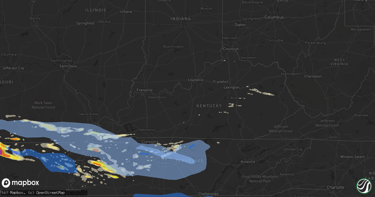
Hail Map in Kentucky on May 3, 2020
Get this storm
May 3 map
$229
one time, instant access
Download today. No call, no setup
Keep the $229
Bought the map and want the full workflow? Apply the entire $229 to a subscription within 7 days. None of it is wasted.
Every map, not just this one
This buys you this map. Subscription and you get every map we run, in the markets you choose from a few cities to whole states to nationwide. Plus real-time alerts the moment a storm fires.
Contact data
Name, contact info, occupancy, even credit band for addresses in the footprint. You go from where it hit to who to call.
Become the source they trust
Unlimited branding weather history reports on demand. You already have the documented answer ready for the property owner, and you are the one who showed up with it.
Property data and RoofTrace estimates
Pull up any address you have got, its value and the exact code rules for that jurisdiction, straight from One Click Code. Then RoofTrace estimates the squares, pitch, and roof value, priced the way you price.
Storm reports in Kentucky
Kentucky
| Date | Description |
|---|---|
| 05/03/20206:58 PM CDT | Tree down on ky hwy 541 just north of ky hwy 52. |
| 05/03/20206:55 PM CDT | Corrects previous tstm wnd dmg report from odds. Tree down on millers creek rd. |
| 05/03/20206:55 PM CDT | A tree was blown down onto powerlines knocking all traffic lights out in the city. |
| 05/03/20206:26 PM CDT | Tree down on mine fork rd. |
| 05/03/20206:17 PM CDT | 3 trees were reported down onto us 460. |
| 05/03/20206:15 PM CDT | Corrects previous tstm wnd dmg report from leatha. Tree down on mine fork rd. |
| 05/03/20206:14 PM CDT | Powerlines were reported to have been blown down at a residence. |
| 05/03/20205:52 PM CDT | Corrects previous tstm wnd dmg report from powell valley. Car struck tree that had been downed over irvine rd. Near intersection with snow creek rd. No fatalities. |
| 05/03/20205:42 PM CDT | Car struck tree over irvine rd. Near intersection with snow creek rd. No fatalities. |
| 05/03/20205:19 PM CDT | The top of a 10 inch diameter cherry tree was snapped. |
| 05/03/20205:15 PM CDT | Reports of multiple tree and limbs down and utility lines down in and near mount sterling. |
| 05/03/20205:13 PM CDT | Large tree limbs down reported via social media with picture. |
| 05/03/20203:20 PM CDT | Dispatch reports tree on power line causing a fire. Brooks chapel rd 1/2 mile n of ky464. Radar estimated time. |
| 05/03/20203:18 PM CDT | Trees down at ky 94 and robertson road. Trees also down at ky 464 and ky 1836. |
| 05/03/20203:12 PM CDT | Tree on residence. Radar estimated time. |
| 05/03/20203:10 PM CDT | Roof peeled back from a horse barn. |
| 05/03/20203:10 PM CDT | A couple trees uprooted. |
| 05/03/20202:52 PM CDT | Report from mping: trees uprooted or snapped; roof blown off. |
| 05/03/20202:51 PM CDT | Numerous trees down including a tree on a home and on a suv. Several power lines down in the area. Occurred near dukedom 1 mile north of the tennessee border. |
| 05/03/20202:51 PM CDT | Report from mping: 3-inch tree limbs broken; power poles broken |
| 05/03/20202:50 PM CDT | Ky mesonet observation. |
| 05/03/20202:48 PM CDT | Report from mping: trees uprooted or snapped; roof blown off |
| 05/03/20202:45 PM CDT | Trees and power lines down just south of graves. Time estimated. |
| 05/03/20202:40 PM CDT | Tree down over i-69 south. Radar estimated time. |
| 05/03/20202:39 PM CDT | Trees down in fulton. Radar estimated time. |
| 05/03/20202:34 PM CDT | Several large tree limb down. |
| 05/03/20202:33 PM CDT | Larger limbs and small trees down west of clinton. Radar estimated time. |
| 05/03/20202:40 AM CDT | At 739 PM EDT, a severe thunderstorm was located over Morrill, or 12 miles northwest of McKee, moving southeast at 30 mph. HAZARD...60 mph wind gusts and penny size hail. SOURCE...Radar indicated. IMPACT...Expect damage to roofs, siding, and trees. Locations impacted include... Manchester, McKee, Booneville, Buckhorn, Turin, Travellers Rest, Bummer, Blake, Robinet, Southfork, Cowcreek and Shop Branch. |
| 05/03/20202:11 AM CDT | At 711 PM EDT, a severe thunderstorm was located near Harris Ferry, or near Richmond, moving east at 40 mph. HAZARD...60 mph wind gusts and penny size hail. SOURCE...Radar indicated. IMPACT...Expect damage to roofs, siding, and trees. Locations impacted include... Irvine, Jackson, Beattyville, Campton, Simpson, Fincastle, Ravenna, Pilot, White Ash, Lexie, Leeco and Fillmore. |
| 05/03/20201:52 AM CDT | At 652 PM EDT, a severe thunderstorm was located over Cat Creek, or over Stanton, moving east at 35 mph. HAZARD...60 mph wind gusts and quarter size hail. SOURCE...Radar indicated. IMPACT...Hail damage to vehicles is expected. Expect wind damage to roofs, siding, and trees. This severe thunderstorm will be near... Bowen around 655 PM EDT. Lombard around 700 PM EDT. Campsites in the Indian Creek area of the Daniel Boone National Forrest around 705 PM EDT. Tabor around 710 PM EDT. Mariba around 715 PM EDT. |
| 05/03/20201:51 AM CDT | At 651 PM EDT, a severe thunderstorm was located over Wellington, or 7 miles southeast of Frenchburg, moving southeast at 40 mph. HAZARD...60 mph wind gusts and quarter size hail. SOURCE...Radar indicated. IMPACT...Hail damage to vehicles is expected. Expect wind damage to roofs, siding, and trees. Locations impacted include... West Liberty, Salyersville, Mason, Henry, Lewis, Wellington, Zag, Burkhart, Florress, Lick Branch, Pekin and Falcon. |
| 05/03/20201:11 AM CDT | At 611 PM EDT, a severe thunderstorm was located over Prewitt, or over Mount Sterling, moving east at 40 mph. HAZARD...60 mph wind gusts and penny size hail. SOURCE...Radar indicated. IMPACT...Expect damage to roofs, siding, and trees. Locations impacted include... Mount Sterling, West Liberty, Owingsville, Frenchburg, Marshall, Henry, Jeffersonville, Camargo, Wellington, Salt Lick, Zag and Levee. |
| 05/03/202012:43 AM CDT | At 542 PM CDT, severe thunderstorms were located along a line extending from near Red Boiling Springs to near Gainesboro to near Baxter, moving east at 50 mph. HAZARD...70 mph wind gusts. SOURCE...Radar indicated. IMPACT...Expect considerable tree damage. Damage is likely to mobile homes, roofs, and outbuildings. Locations impacted include... Cookeville, Livingston, Jamestown, Celina, Byrdstown, Algood, Monterey, Allardt, Grimsley, Moss, Rickman, Pall Mall, Wolf River Dock, Clarkrange, Crawford, Dale Hollow Lake, Pickett State Park, Standing Stone State Park and Ashlock.This includes Interstate 40 between mile markers 285 and 301. |
| 05/03/202012:11 AM CDT | At 510 PM CDT, severe thunderstorms were located along a line extending from near Westmoreland to near Watertown, moving east at 65 mph. These are very dangerous storms. HAZARD...80 mph wind gusts and penny size hail. SOURCE...Radar indicated. IMPACT...Flying debris will be dangerous to those caught without shelter. Mobile homes will be heavily damaged. Expect considerable damage to roofs, windows, and vehicles. Extensive tree damage and power outages are likely. Locations impacted include... Cookeville, Lafayette, Carthage, Gainesboro, Hartsville, Westmoreland, Watertown, Baxter, Gordonsville, Red Boiling Springs, Hickman, South Carthage, Alexandria, Dowelltown, Liberty, Hamptons Crossroads, Moss, Pleasant Shade, Dickerson Chapel Recreation Area and Center Hill Lake.This includes Interstate 40 between mile markers 241 and 289. |
| 05/02/202011:43 PM CDT | At 443 PM CDT, severe thunderstorms were located along a line extending from near Springfield to near White House to near Hermitage, moving northeast at 65 mph. HAZARD...60 mph wind gusts and nickel size hail. SOURCE...Radar indicated. IMPACT...Expect damage to roofs, siding, and trees. Locations impacted include... Gallatin, Lebanon, Springfield, Hartsville, Madison, Hendersonville, Mount Juliet, Goodlettsville, White House, Millersville, Lakewood, Westmoreland, Ridgetop, Cross Plains, Portland, Hermitage, Belinda City, Old Hickory, Rural Hill and Orlinda. |
| 05/02/202011:11 PM CDT | At 411 PM CDT, severe thunderstorms were located along a line extending from near Oak Grove to 14 miles west of Ashland City to near White Bluff, moving east at 60 mph. HAZARD...70 mph wind gusts and penny size hail. SOURCE...Radar indicated. IMPACT...Expect considerable tree damage. Damage is likely to mobile homes, roofs, and outbuildings. Locations impacted include... Springfield, Ashland City, Nashville, Clarksville, Madison, Hendersonville, Goodlettsville, White House, Millersville, Greenbrier, Coopertown, Lakewood, Ridgetop, Cross Plains, Guthrie, Hermitage, Old Hickory, Joelton, Pleasant View and Orlinda. |
| 05/02/202010:44 PM CDT | At 343 PM CDT, severe thunderstorms were located along a line extending from 7 miles west of Big Rock to near Tennessee Ridge to near Waverly, moving east at 50 mph. These are very dangerous storms. HAZARD...80 mph wind gusts and nickel size hail. SOURCE...Radar indicated. IMPACT...Flying debris will be dangerous to those caught without shelter. Mobile homes will be heavily damaged. Expect considerable damage to roofs, windows, and vehicles. Extensive tree damage and power outages are likely. Locations impacted include... Clarksville, Charlotte, Vanleer, Cumberland City, Slayden, Cheatham Dam, Palmyra, Cunningham and Woodlawn.This includes Interstate 24 between mile markers 1 and 15. |
| 05/02/202010:27 PM CDT | At 327 PM CDT, severe thunderstorms were located along a line extending from Paris Landing State Park to 6 miles southeast of Springville to near Bruceton, moving east at 55 mph. HAZARD...70 mph wind gusts. SOURCE...Radar indicated. IMPACT...Expect considerable tree damage. Damage is likely to mobile homes, roofs, and outbuildings. Locations impacted include... Camden, Paris Landing State Park, Bruceton, Vale, Springville, Hollow Rock, Big Sandy, Haigler Ridge, Manleyville, Old Springville, Buchanan, Sunnyside, Spring Creek, Pine Hill, Nathan Bedford Forrest State Park and Big Sandy Unit Tennessee National Wildlife Refuge. |
| 05/02/20209:38 PM CDT | At 238 PM CDT, severe thunderstorms were located along a line extending from near South Fulton to near Martin to near Newbern, moving east at 65 mph. HAZARD...70 mph wind gusts and quarter size hail. SOURCE...Radar indicated. IMPACT...Hail damage to vehicles is expected. Expect considerable tree damage. Wind damage is also likely to mobile homes, roofs, and outbuildings. Locations impacted include... Martin, Paris, McKenzie, Trenton, Huntingdon, Camden, Paris Landing State Park, Dresden, Dyer, Greenfield, New Johnsonville, Bruceton, Gleason, Kenton, Rutherford, Bradford, Sharon, Atwood, Cottage Grove and Latham. |
| 05/02/20208:30 PM CDT | At 130 PM CDT, severe thunderstorms were located along a line extending from near Glennonville to near Oak Grove Heights, moving east at 70 mph. HAZARD...70 mph wind gusts and half dollar size hail. SOURCE...Radar indicated. IMPACT...Hail damage to vehicles is expected. Expect considerable tree damage. Wind damage is also likely to mobile homes, roofs, and outbuildings. Locations impacted include... Paragould, Dyersburg, Kennett, Caruthersville, Piggott, Portageville, Hayti, Steele, Campbell, Rector, Senath, Marmaduke, Reelfoot Lake State Park, Chalk Bluff Natural Area, Tiptonville, Malden, Ridgely, Oak Grove Heights, Cardwell and Hornersville. |
| 05/02/20208:22 PM CDT | At 121 PM CDT, severe thunderstorms were located along a line extending from near Greenville to Fisk to near McDougal, moving east at 65 mph. HAZARD...70 mph wind gusts and quarter size hail. SOURCE...Trained weather spotters. IMPACT...Hail damage to vehicles is expected. Expect considerable tree damage. Wind damage is also likely to mobile homes, roofs, and outbuildings. Locations impacted include... Sikeston, Dexter, Charleston, Portageville, East Prairie, New Madrid, Cairo, Bernie, Bloomfield, Advance, Oran, Lilbourn, Miner, Benton, Towosahgy State Historic Site, Big Oak Tree State Park, Hunter-Dawson State Historic Site, Malden, Clarkton and Gideon.This includes the following highways... Interstate 57 in Missouri between Mile Markers 1 and 21. Interstate 55 between Mile Markers 33 and 81. |
| 05/02/20207:05 PM CDT | Tree blown onto a powerline knocking the powerline into the road on ky 587. |
All States Impacted by Hail Map on May 3, 2020
Cities Impacted by Hail Map on May 3, 2020
- Wray, CO
- Eckley, CO
- Haigler, NE
- Westport, TN
- Osceola, AR
- Valley Springs, AR
- Pyatt, AR
- Harrison, AR
- Summit, AR
- Melbourne, AR
- Flippin, AR
- Norfork, AR
- Theodosia, MO
- Calico Rock, AR
- Lead Hill, AR
- Protem, MO
- Yellville, AR
- Rueter, MO
- Peel, AR
- Ravenden, AR
- Ravenden Springs, AR
- Somerville, TN
- Chapman, KS
- Enterprise, KS
- Solomon, KS
- Abilene, KS
- Sturgis, SD
- Mayfield, KY
- Clinton, KY
- Kirksey, KY
- Almo, KY
- Murray, KY
- Wingo, KY
- Fulton, KY
- Sedalia, KY
- Farmington, KY
- Limon, CO
- Elbert, CO
- Sterling, CO
- Merino, CO
- Toronto, KS
- Virgil, KS
- Yates Center, KS
- Bronte, TX
- Gypsum, KS
- Big Springs, NE
- Chappell, NE
- Bon Aqua, TN
- Dickson, TN
- Mount Juliet, TN
- Madison, TN
- Old Hickory, TN
- Hermitage, TN
- Nashville, TN
- Upton, WY
- Fremont, MO
- Birch Tree, MO
- Van Buren, MO
- Grandin, MO
- Eminence, MO
- Winona, MO
- Poplar Bluff, MO
- Ellsinore, MO
- Kilgore, NE
- Cody, NE
- Nenzel, NE
- Galesburg, KS
- West Plains, MO
- Purcell, MO
- Jasper, MO
- Carthage, MO
- Alba, MO
- Oronogo, MO
- Webb City, MO
- Atwood, KS
- McDonald, KS
- Henderson, TN
- Luray, TN
- Jacks Creek, TN
- Beech Bluff, TN
- Pinson, TN
- Jackson, TN
- Vernon, CO
- Yuma, CO
- Kimberling City, MO
- Shell Knob, MO
- Lampe, MO
- Blue Eye, MO
- Branson, MO
- Reeds Spring, MO
- Kirbyville, MO
- Ridgedale, MO
- Hollister, MO
- Fort Scott, KS
- Fulton, KS
- Reeds, MO
- Stotts City, MO
- Avilla, MO
- Sarcoxie, MO
- La Russell, MO
- Walnut Ridge, AR
- Lebanon, TN
- Castalian Springs, TN
- Gallatin, TN
- Marathon, TX
- Akron, CO
- Stanton, TN
- Brownsville, TN
- Henning, TN
- Blytheville, AR
- Atoka, TN
- Luxora, AR
- Brighton, TN
- Covington, TN
- Mason, TN
- Ripley, TN
- Burlison, TN
- Gill, CO
- Fredonia, KS
- Scammon, KS
- McCune, KS
- West Mineral, KS
- Mindenmines, MO
- Arma, KS
- Frontenac, KS
- Pittsburg, KS
- Weir, KS
- Asbury, MO
- Girard, KS
- Cherokee, KS
- Franklin, KS
- Greensburg, KY
- Cottontown, TN
- Portland, TN
- White House, TN
- Dyersburg, TN
- Huntingdon, TN
- Atwood, TN
- Wanblee, SD
- Elsie, NE
- Julesburg, CO
- Grant, NE
- Wauneta, NE
- Madrid, NE
- Hayes Center, NE
- Venango, NE
- Imperial, NE
- Dyer, TN
- Buffalo, SD
- Colby, KS
- Batavia, OH
- Smithville, AR
- Wiggins, CO
- Brush, CO
- Delaplaine, AR
- Mertzon, TX
- Hamilton, KS
- East Prairie, MO
- Parks, NE
- Holcomb, MO
- Carlsbad, TX
- Robert Lee, TX
- Black Hawk, SD
- Piedmont, SD
- Kyle, SD
- Long Valley, SD
- Box Elder, SD
- Saint Francis, SD
- Deadwood, SD
- Tuthill, SD
- Martin, SD
- Interior, SD
- Rapid City, SD
- Ellsworth Afb, SD
- New Underwood, SD
- Norris, SD
- Wall, SD
- Scenic, SD
- Caputa, SD
- Flagler, CO
- Hugo, CO
- Seibert, CO
- Simla, CO
- Genoa, CO
- Arriba, CO
- Matheson, CO
- Waverly, TN
- Ogallala, NE
- Ramah, CO
- Calhan, CO
- Martin, TN
- Oakfield, TN
- Broseley, MO
- Denmark, TN
- West Liberty, KY
- Jonesboro, AR
- Lake City, AR
- Bay, AR
- Jordan, MT
- Fort Meade, SD
- Whitewood, SD
- Troy, TN
- Rives, TN
- Hornbeak, TN
- Ridgely, TN
- Obion, TN
- Wellington, KS
- Dudley, MO
- Wappapello, MO
- Williamsville, MO
- Puxico, MO
- Fisk, MO
- Jerico Springs, MO
- Latham, KS
- Dora, MO
- Omaha, AR
- Goodlettsville, TN
- Hendersonville, TN
- Kanorado, KS
- Bethune, CO
- Stratton, CO
- Burlington, CO
- Aurora, MO
- Lobelville, TN
- Hurricane Mills, TN
- Woodrow, CO
- Humboldt, TN
- Alamo, TN
- Gadsden, TN
- Medina, TN
- Friendship, TN
- Lexington, TN
- Blackwell, TX
- Lawrenceburg, IN
- Harrison, OH
- North Bend, OH
- Doniphan, MO
- Pocahontas, AR
- Imboden, AR
- Summersville, MO
- Russell, KS
- Dorrance, KS
- Bunker Hill, KS
- Hartville, MO
- Marshfield, MO
- Niangua, MO
- Stoneham, CO
- Caulfield, MO
- Miller, MO
- Rector, AR
- Boyes, MT
- Willow Springs, MO
- Crane, MO
- Fleming, CO
- Atwood, CO
- Goodland, KS
- Whites Creek, TN
- Whiteville, TN
- Orchard, CO
- Alzada, MT
- Briggsdale, CO
- Fort Morgan, CO
- Salina, KS
- Benedict, KS
- Chanute, KS
- Belle Fourche, SD
- Hammond, MT
- Lemoyne, NE
- Lewellen, NE
- Essex, MO
- Agate, CO
- Decker, MT
- Wingate, TX
- Tuscola, TX
- Worden, MT
- Keystone, NE
- Paxton, NE
- Humboldt, KS
- Buffalo, KS
- Madison, KS
- Eureka, KS
- Piqua, KS
- Erie, KS
- Sylvan Grove, KS
- Wilson, KS
- Buena Vista, TN
- Abilene, TX
- Merkel, TX
- Keystone, SD
- Hill City, SD
- Custer, SD
- Hermosa, SD
- Columbus, KY
- Matthews, MO
- Ash Grove, MO
- Bois D Arc, MO
- Champion, NE
- Joelton, TN
- Whitman, NE
- Hyannis, NE
- Neck City, MO
- De Mossville, KY
- Butler, KY
- Highlandville, MO
- Galena, MO
- Clever, MO
- Billings, MO
- Walnut Grove, MO
- Aldrich, MO
- Morrisville, MO
- Bolivar, MO
- Lance Creek, WY
- Cabool, MO
- Snyder, CO
- Max, NE
- Benkelman, NE
- Cherryvale, KS
- Neodesha, KS
- Elk City, KS
- Independence, KS
- Republican City, NE
- Springfield, MO
- Willard, MO
- Fancy Farm, KY
- Dexter, KY
- Cincinnati, OH
- Osage City, KS
- Saint Paul, KS
- Walnut, KS
- Trenton, TN
- Maynard, AR
- Corning, AR
- Biggers, AR
- Ballinger, TX
- Winters, TX
- Danforth, ME
- Moundville, MO
- Uniontown, KS
- Arcadia, KS
- Garland, KS
- Bronaugh, MO
- Buffalo Gap, TX
- Volborg, MT
- Monett, MO
- Marionville, MO
- Columbus, KS
- Pierce City, MO
- Carl Junction, MO
- Nixa, MO
- Ozark, MO
- Golden City, MO
- Freistatt, MO
- Galena, KS
- Mount Vernon, MO
- Verona, MO
- Wentworth, MO
- Tiptonville, TN
- Pontiac, MO
- Midway, AR
- Everton, AR
- Cape Fair, MO
- Cotter, AR
- Cedarcreek, MO
- Oxford, AR
- Brockwell, AR
- Viola, AR
- Pineville, AR
- Elizabeth, AR
- Salem, AR
- Gassville, AR
- Golden, MO
- Oakland, AR
- Sage, AR
- Franklin, AR
- Wideman, AR
- Dolph, AR
- Bexar, AR
- Mountain Home, AR
- Lakeview, AR
- Cassville, MO
- Bull Shoals, AR
- Altamont, KS
- Parsons, KS
- Pottersville, MO
- Otter, MT
- Norman, IN
- Liberal, MO
- Paragould, AR
- Cumberland Furnace, TN
- Vanleer, TN
- Weldona, CO
- Cheyenne, WY
- Allen, SD
- Byers, CO
- Ashland City, TN
- Sikeston, MO
- Bloomfield, MO
- Dexter, MO
- Forsyth, MO
- Rockaway Beach, MO
- Taneyville, MO
- Longton, KS
- Otis, CO
- Heltonville, IN
- Bedford, IN
- Vona, CO
- Fordland, MO
- Seymour, MO
- Broadwater, NE
- Brownstown, IN
- Medora, IN
- Redfield, KS
- Severy, KS
- Fall River, KS
- Gates, TN
- Howard, KS
- Knobel, AR
- Warm Springs, AR
- Peach Orchard, AR
- Success, AR
- Purdy, MO
- Salyersville, KY
- Wiseman, AR
- Glencoe, AR
- Ash Flat, AR
- Horseshoe Bend, AR
- Arthur, NE
- Tryon, NE
- Colony, KS
- Westphalia, KS
- McKee, KY
- Mount Vernon, KY
- Berea, KY
- Charlotte, TN
- Moody, MO
- Tecumseh, MO
- Beaver City, NE
- Mountain View, MO
- Nunnelly, TN
- Only, TN
- Lyles, TN
- Duck River, TN
- Centerville, TN
- Bradford, TN
- Piedmont, KS
- Beaumont, KS
- Leon, KS
- Iola, KS
- Union City, TN
- Hay Springs, NE
- Blue Mound, KS
- Mapleton, KS
- Mound City, KS
- Lancaster, KY
- Datto, AR
- Greenfield, MO
- Alicia, AR
- Portia, AR
- Hoxie, AR
- Wildersville, TN
- Darden, TN
- Commiskey, IN
- Hartsville, TN
- Linden, TN
- Denniston, KY
- Wellington, KY
- Ezel, KY
- Frenchburg, KY
- Salt Lick, KY
- Gepp, AR
- Medon, TN
- Mercer, TN
- Grover, CO
- Chadwick, MO
- Chestnutridge, MO
- Ponce De Leon, MO
- Lockwood, MO
- Sparta, MO
- South Greenfield, MO
- Everton, MO
- Republic, MO
- Oldfield, MO
- Spokane, MO
- Cedar Grove, TN
- Clifton, TN
- Madison, IN
- Florence, IN
- Bennington, IN
- Vevay, IN
- Stratton, NE
- Winchester, OH
- Brentwood, TN
- Mount Orab, OH
- Sardinia, OH
- Oswego, KS
- Cottage Grove, TN
- Paris, TN
- Erin, TN
- Holladay, TN
- Ovalo, TX
- Lawn, TX
- Huron, TN
- Reagan, TN
- Newcastle, WY
- Trenton, NE
- Talpa, TX
- Oberlin, KS
- Herndon, KS
- Kenton, TN
- Broadus, MT
- Cadiz, KY
- Mount Sterling, KY
- Orleans, NE
- Alma, NE
- Camden, TN
- Brule, NE
- Exeter, MO
- Norwood, MO
- Big Lake, TX
- Mound Valley, KS
- Sidney, AR
- Verona, KY
- Warsaw, KY
- Deputy, IN
- Paris Crossing, IN
- Piggott, AR
- Saint Francis, AR
- Campbell, MO
- Rogersville, MO
- Haxtun, CO
- Sedgwick, CO
- Bells, TN
- Halls, TN
- Milan, TN
- Water Valley, KY
- Keenesburg, CO
- Springfield, TN
- Chapmansboro, TN
- Cedar Hill, TN
- Pleasant View, TN
- Brookland, AR
- Sturkie, AR
- Thornfield, MO
- New Concord, KY
- Clyde, TX
- Oxly, MO
- Naylor, MO
- Leachville, AR
- Monette, AR
- Dell, AR
- Manila, AR
- Pleasanton, KS
- Bruner, MO
- Clarksville, TN
- Sunman, IN
- Milan, IN
- Deer Trail, CO
- Greeley, CO
- Hardy, AR
- Etowah, AR
- Lavinia, TN
- Duenweg, MO
- Diamond, MO
- Joplin, MO
- Black Oak, AR
- Caraway, AR
- Mammoth Spring, AR
- Scotts Hill, TN
- Sardis, TN
- Portageville, MO
- Greenfield, TN
- Rutherford, TN
- Parsons, TN
- Decaturville, TN
- Trezevant, TN
- Finley, TN
- Lincoln, KS
- Bolivar, TN
- Toone, TN
- La Harpe, KS
- Moran, KS
- Cherokee Village, AR
- Richmond, KY
- Irvine, KY
- Guilford, IN
- Stanton, KY
- Cardwell, MO
- Arbyrd, MO
- Houston, MO
- Elk Creek, MO
- Solo, MO
- Graff, MO
- Mountain Grove, MO
- Hillrose, CO
- Gainesville, MO
- Roggen, CO
- Nevada, MO
- Bono, AR
- Palmersville, TN
- Burns, TN
- Clay City, KY
- Wilson, AR
- Catron, MO
- Hickman, KY
- Bertrand, MO
- Charleston, MO
- Arlington, KY
- New Madrid, MO
- Bethpage, TN
- Westmoreland, TN
- State University, AR
- Smiths Grove, KY
- Henry, TN
- Coffeyville, KS
- Bartlett, KS
- Atlanta, KS
- Liberty, KS
- Augusta, KS
- Edna, KS
- Eubank, KY
- Waynesburg, KY
- Franklin, TN
- Hayti, MO
- Bragg City, MO
- Wardell, MO
- Devils Tower, WY
- Hazel, KY
- Buchanan, TN
- Wytopitlock, ME
- Poughkeepsie, AR
- Cave City, AR
- Powersite, MO
- Evening Shade, AR
- Mount Pleasant, AR
- Gamaliel, AR
- Bradleyville, MO
- Dyess, AR
- Pall Mall, TN
- Jamestown, TN
- Bird City, KS
- Williamsburg, OH
- Dadeville, MO
- Middleburg, KY
- Kings Mountain, KY
- Paint Lick, KY
- Stanford, KY
- Crab Orchard, KY
- Kincaid, KS
- Welda, KS
- Springville, IN
- Mize, KY
- Liberty, KY
- Arlington, TN
- Black Rock, AR
- Powhatan, AR
- Seymour, IN
- Neosho Falls, KS
- Gridley, KS
- Ellsworth, KS
- Elizabeth, CO
- Oshkosh, NE
- Lodgepole, NE
- Sidney, NE
- Bronson, KS
- Hartsville, IN
- Columbus, IN
- Beech Grove, AR
- Merom, IN
- Carlisle, IN
- Greenbrier, TN
- Marmaduke, AR
- Means, KY
- Jeffersonville, KY
- Nemo, SD
- Fairburn, SD
- Capitol, MT
- Wibaux, MT
- Sentinel Butte, ND
- Beach, ND
- Kissee Mills, MO
- Brighton, MO
- Harbeson, DE
- Rehoboth Beach, DE
- Millsboro, DE
- Lewes, DE
- Lamar, MO
- Arcola, MO
- Stockton, MO
- Walnut Shade, MO
- Shelbyville, TN
- Gleason, TN
- Hickman, TN
- Carthage, TN
- Hilham, TN
- Whitleyville, TN
- Hampshire, TN
- Auburntown, TN
- Woodbury, TN
- Clarkton, MO
- Manchester, TN
- Pollard, AR
- Macomb, MO
- Buffalo Valley, TN
- Mount Pleasant, TN
- Morrison, TN
- Culleoka, TN
- Beechgrove, TN
- Brandsville, MO
- Mill Spring, MO
- Southside, TN
- Smithville, TN
- Indian Mound, TN
- Readyville, TN
- Big Sandy, TN
- Rickman, TN
- Bardwell, KY
- Steele, MO
- Granville, TN
- Zalma, MO
- College Grove, TN
- Lewisburg, TN
- Normandy, TN
- Watertown, TN
- Squires, MO
- Sharon, TN
- Fairview, TN
- Cumberland City, TN
- Qulin, MO
- Greenville, MO
- Lascassas, TN
- Primm Springs, TN
- Kennett, MO
- Williamsport, TN
- Pomona, MO
- Spencer, TN
- Hohenwald, TN
- Lafayette, TN
- Bernie, MO
- Neelyville, MO
- Sugar Tree, TN
- La Vergne, TN
- Couch, MO
- Newbern, TN
- Fairdealing, MO
- Stewart, TN
- Kingston Springs, TN
- Doyle, TN
- Gordonsville, TN
- Chapel Hill, TN
- Spring Hill, TN
- Milton, TN
- Alexandria, TN
- Eva, TN
- McKenzie, TN
- Murfreesboro, TN
- Smyrna, TN
- Bradyville, TN
- Columbia, TN
- Bell City, MO
- Drury, MO
- Walling, TN
- Silver Point, TN
- Gideon, MO
- Cookeville, TN
- Antioch, TN
- Moss, TN
- Palmyra, TN
- Sturdivant, MO
- Harviell, MO
- Elmwood, TN
- Celina, TN
- Koshkonong, MO
- Rockvale, TN
- Rock Island, TN
- Canalou, MO
- Bell Buckle, TN
- Quebeck, TN
- Hollow Rock, TN
- Pleasant Shade, TN
- Dover, TN
- Dowelltown, TN
- Parma, MO
- Yuma, TN
- Mcminnville, TN
- Oran, MO
- Bloomington Springs, TN
- Trimble, TN
- Baxter, TN
- Wartrace, TN
- Woodlawn, TN
- Mansfield, MO
- Advance, MO
- Gibson, MO
- McGee, MO
- Christiana, TN
- Vanzant, MO
- Malden, MO
- Greenway, AR
- Liberty, TN
- Lancaster, TN
- Brush Creek, TN
- Puryear, TN
- Livingston, TN
- Thayer, MO
- White Bluff, TN
- McEwen, TN
- Peace Valley, MO
- Springville, TN
- Arrington, TN
- Allons, TN
- Thompsons Station, TN
- Riddleton, TN
- Gainesboro, TN
- Alton, MO
- Pegram, TN
- Eagleville, TN
- Dukedom, TN
- Dresden, TN
- Caruthersville, MO
- Nolensville, TN
- Bruceton, TN
- Lilbourn, MO
- Santa Fe, TN
- Dixon Springs, TN
- Marston, MO
- South Fulton, TN
- Unionville, TN
- Ava, MO
- Piedmont, MO
- Tennessee Ridge, TN
- Sparta, TN
- Chestnut Mound, TN
- Cunningham, TN
- Vanduser, MO
- Red Boiling Springs, TN
- Anniston, MO
- New Johnsonville, TN
- Mansfield, TN
- Lynn, AR
- Williford, AR
- Weiner, AR
- O'Kean, AR
- Violet Hill, AR
- Lafe, AR
- Cash, AR
- Hornersville, MO
- Trumann, AR
- Keiser, AR
- Swifton, AR
- Marked Tree, AR
- Lepanto, AR
- Harrisburg, AR
- Lookout Mountain, GA
- Flintville, TN
- Ardmore, TN
- Killen, AL
- Toney, AL
- Elkmont, AL
- Ringgold, GA
- Rock Spring, GA
- Stevenson, AL
- Menlo, GA
- Waterloo, AL
- Tunnel Hill, GA
- Lester, AL
- Higdon, AL
- Huntland, TN
- Hollywood, AL
- New Market, AL
- Fackler, AL
- Ider, AL
- La Fayette, GA
- Rogersville, AL
- Anderson, AL
- Rocky Face, GA
- Meridianville, AL
- Rossville, GA
- Estillfork, AL
- Chickamauga, GA
- Trenton, GA
- Saint Joseph, TN
- Minor Hill, TN
- Kelso, TN
- Wildwood, GA
- Fort Oglethorpe, GA
- Flat Rock, AL
- Elora, TN
- Five Points, TN
- Fayetteville, TN
- Hazel Green, AL
- Bryant, AL
- Taft, TN
- Pisgah, AL
- Florence, AL
- Prospect, TN
- Scottsboro, AL
- Trion, GA
- Cypress Inn, TN
- Bridgeport, AL
- Rising Fawn, GA
- Ardmore, AL
- Loretto, TN
- Lutts, TN
- Iron City, TN
- Flintstone, GA
- Athens, AL
- Lexington, AL
- King George, VA
- Elsmore, KS
- Chetopa, KS
- Iliff, CO
- Kiowa, CO
- Bennett, CO


