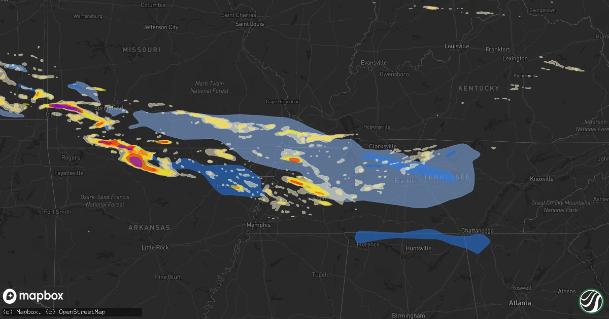
Hail Map on May 3, 2020
Get this storm
May 3 map
$229
one time, instant access
Download today. No call, no setup
Keep the $229
Bought the map and want the full workflow? Apply the entire $229 to a subscription within 7 days. None of it is wasted.
Every map, not just this one
This buys you this map. Subscription and you get every map we run, in the markets you choose from a few cities to whole states to nationwide. Plus real-time alerts the moment a storm fires.
Contact data
Name, contact info, occupancy, even credit band for addresses in the footprint. You go from where it hit to who to call.
Become the source they trust
Unlimited branding weather history reports on demand. You already have the documented answer ready for the property owner, and you are the one who showed up with it.
Property data and RoofTrace estimates
Pull up any address you have got, its value and the exact code rules for that jurisdiction, straight from One Click Code. Then RoofTrace estimates the squares, pitch, and roof value, priced the way you price.
States Impacted by Hail Map on May 3, 2020
Storm reports
South Dakota
| Date | Description |
|---|---|
| 05/03/20206:02 PM CDT | A local report indicates 1.75 inch wind near 4 NE FARMINGDALE |
| 05/03/20206:00 PM CDT | A local report indicates 1.00 inch wind near 3 SSE DWTN RAPID CITY |
| 05/03/20205:25 PM CDT | A local report indicates 1.50 inch wind near 4 WNW RAPID CITY ARPT |
| 05/03/20205:19 PM CDT | Delayed report... Uncertain duration... Time estimated from radar |
| 05/03/20205:07 PM CDT | North haines fire department |
| 05/03/20205:06 PM CDT | Up to ping pong ball size hail |
| 05/03/20205:02 PM CDT | A local report indicates 1.50 inch wind near 3 E BLACK HAWK |
| 05/03/20205:00 PM CDT | A local report indicates 1.00 inch wind near 4 N DWTN RAPID CITY |
| 05/03/20205:00 PM CDT | A local report indicates 1.25 inch wind near 4 E BLACK HAWK |
| 05/03/20204:54 PM CDT | A local report indicates 1.00 inch wind near 4 E BLACK HAWK |
| 05/03/20204:38 PM CDT | A local report indicates 1.00 inch wind near BLACK HAWK |
| 05/03/20204:36 PM CDT | A local report indicates 1.75 inch wind near STURGIS |
| 05/03/20204:31 PM CDT | A local report indicates 1.00 inch wind near STURGIS |
| 05/03/20204:20 PM CDT | A local report indicates 1.00 inch wind near STURGIS |
| 05/03/20204:18 PM CDT | Mostly pea to marble size hail. A few up to quarter size |
| 05/03/20204:10 PM CDT | Mostly peas... But lots of it |
| 05/03/20203:50 PM CDT | A local report indicates 1.25 inch wind near 3 ENE DEADWOOD |
| 05/03/20203:44 AM CDT | At 844 PM MDT/944 PM CDT/, a severe thunderstorm was located over Vetal, or 20 miles east of Martin, moving southeast at 30 mph. HAZARD...60 mph wind gusts and half dollar size hail. SOURCE...Radar indicated. IMPACT...Hail damage to vehicles is expected. Expect wind damage to roofs, siding, and trees. This severe thunderstorm will be near... Harrington around 855 PM MDT. |
| 05/03/20202:57 AM CDT | At 757 PM MDT/857 PM CDT/, a severe thunderstorm was located 4 miles southeast of Eagle Nest Butte, or 18 miles north of Martin, moving east at 25 mph. HAZARD...60 mph wind gusts and half dollar size hail. SOURCE...Radar indicated. IMPACT...Hail damage to vehicles is expected. Expect wind damage to roofs, siding, and trees. This severe thunderstorm will be near... Long Valley around 805 PM MDT. |
| 05/03/20202:05 AM CDT | At 705 PM MDT, a severe thunderstorm was located 4 miles northeast of Potato Creek, or 27 miles southwest of Kadoka, moving southeast at 30 mph. HAZARD...70 mph wind gusts and half dollar size hail. SOURCE...Radar indicated. IMPACT...Hail damage to vehicles is expected. Expect considerable tree damage. Wind damage is also likely to mobile homes, roofs, and outbuildings. This severe thunderstorm will be near... Snake Butte around 720 PM MDT. Hisle and Eagle Nest Butte around 735 PM MDT. |
| 05/03/20201:44 AM CDT | At 643 PM MDT, a severe thunderstorm was located over northeastern Custer State Park, or 9 miles east of Custer, moving east at 30 mph. HAZARD...Golf ball size hail and 60 mph wind gusts. SOURCE...Radar indicated. IMPACT...People and animals outdoors will be injured. Expect hail damage to roofs, siding, windows, and vehicles. Expect wind damage to roofs, siding, and trees. This severe thunderstorm will be near... Hermosa around 700 PM MDT. Fairburn around 710 PM MDT. |
| 05/03/20201:14 AM CDT | At 614 PM MDT, a severe thunderstorm was located 8 miles east of Badlands National Park, or 38 miles southwest of Philip, moving southeast at 25 mph. HAZARD...60 mph wind gusts and quarter size hail. SOURCE...Radar indicated. IMPACT...Hail damage to vehicles is expected. Expect wind damage to roofs, siding, and trees. This severe thunderstorm will be near... Interior and Cedar Pass around 655 PM MDT. Potato Creek around 710 PM MDT.This includes Interstate 90 in South Dakota between Mile Markers 127and 134. |
| 05/03/20201:07 AM CDT | At 606 PM MDT, a severe thunderstorm was located 3 miles west of Bear Mountain Lookout, or 11 miles west of Hill City, moving southeast at 25 mph. HAZARD...Quarter size hail. SOURCE...Radar indicated. IMPACT...Damage to vehicles is expected. This severe thunderstorm will be near... Bear Mountain Lookout and Medicine Mountain around 615 PM MDT. Hill City and Crazy Horse Memorial around 630 PM MDT. Northwestern Custer State Park, Sylvan Lake, Black Elk Peak and Palmer Gulch Resort around 635 PM MDT. Custer and Horse Thief Lake around 640 PM MDT. Stockade Lake, Legion Lake, Mount Coolidge, Center Lake, Black Hills Playhouse and Mount Rushmore National Memorial around 645 PM MDT. |
| 05/03/202012:19 AM CDT | At 519 PM MDT, a severe thunderstorm was located 6 miles east of Osage, or 10 miles northwest of Newcastle, moving southeast at 25 mph. HAZARD...Ping pong ball size hail and 60 mph wind gusts. SOURCE...Radar indicated. IMPACT...People and animals outdoors will be injured. Expect hail damage to roofs, siding, windows, and vehicles. Expect wind damage to roofs, siding, and trees. This severe thunderstorm will be near... Moon and Redbank Spring Campground around 550 PM MDT. |
| 05/03/202012:16 AM CDT | At 516 PM CDT/416 PM MDT/, a severe thunderstorm was located near Cody, or 27 miles southeast of Martin, moving east at 15 mph. HAZARD...60 mph wind gusts and quarter size hail. SOURCE...Radar indicated. IMPACT...Hail damage to vehicles is expected. Expect wind damage to roofs, siding, and trees. This severe thunderstorm will be near... Cody around 425 PM MDT. Nenzel around 455 PM MDT. Kilgore around 500 PM MDT.Other locations impacted by this severe thunderstorm include CodyLake.This includes Highway 20 between mile markers 150 and 176. |
| 05/03/202012:15 AM CDT | At 515 PM MDT, severe thunderstorms were located along a line extending from 6 miles northwest of Owanka to 9 miles east of Farmingdale to 3 miles northeast of Railroad Buttes, moving southeast at 35 mph. HAZARD...60 mph wind gusts and half dollar size hail. SOURCE...Radar indicated. IMPACT...Hail damage to vehicles is expected. Expect wind damage to roofs, siding, and trees. Severe thunderstorms will be near... Owanka and Wicksville around 525 PM MDT. Wasta around 535 PM MDT. Scenic and Sheep Mountain Table around 545 PM MDT. Northern Badlands National Park around 550 PM MDT. Pinnacles Ranger Station around 605 PM MDT.This includes Interstate 90 in South Dakota between Mile Markers 81and 119. |
| 05/03/202012:04 AM CDT | At 504 PM MDT, a severe thunderstorm was located near Rapid Valley, or 4 miles southeast of Rapid City, moving east at 20 mph. HAZARD...Quarter size hail. SOURCE...Radar indicated. IMPACT...Damage to vehicles is expected. This severe thunderstorm will be near... Rapid City Airport around 520 PM MDT. Caputa around 535 PM MDT. Thompson Butte around 540 PM MDT. |
| 05/02/202011:46 PM CDT | At 446 PM MDT, a severe thunderstorm was located 6 miles northwest of Swett, or 16 miles west of Martin, moving northeast at 25 mph. HAZARD...Quarter size hail. SOURCE...Radar indicated. IMPACT...Damage to vehicles is expected. This severe thunderstorm will be near... Allen around 500 PM MDT. Snake Butte around 525 PM MDT. Hisle around 530 PM MDT. |
| 05/02/202011:14 PM CDT | At 414 PM MDT, a severe thunderstorm was located over northern Rapid Valley, or 5 miles east of Rapid City, moving east at 15 mph. HAZARD...Ping pong ball size hail and 60 mph wind gusts. SOURCE...Radar indicated. IMPACT...People and animals outdoors will be injured. Expect hail damage to roofs, siding, windows, and vehicles. Expect wind damage to roofs, siding, and trees. This severe thunderstorm will be near... Box Elder around 420 PM MDT. Rapid City Airport around 430 PM MDT. Caputa around 450 PM MDT. New Underwood and Farmingdale around 505 PM MDT.This includes Interstate 90 in South Dakota between Mile Markers 61and 88. |
| 05/02/202010:37 PM CDT | At 336 PM MDT, a severe thunderstorm was located over Black Hawk, or 5 miles northwest of Rapid City, moving east at 15 mph. HAZARD...Ping pong ball size hail and 60 mph wind gusts. SOURCE...Radar indicated. IMPACT...People and animals outdoors will be injured. Expect hail damage to roofs, siding, windows, and vehicles. Expect wind damage to roofs, siding, and trees. This severe thunderstorm will be near... Rapid City around 350 PM MDT. Rapid Valley and Ellsworth Air Force Base around 410 PM MDT. Box Elder around 420 PM MDT.This includes Interstate 90 in South Dakota between Mile Markers 51and 67. |
| 05/02/202010:30 PM CDT | At 330 PM MDT, a severe thunderstorm was located over Fort Meade, or 3 miles southeast of Sturgis, moving east at 15 mph. HAZARD...60 mph wind gusts and half dollar size hail. SOURCE...Radar indicated. IMPACT...Hail damage to vehicles is expected. Expect wind damage to roofs, siding, and trees. Hail may accumulate on roadways causing hazardous travel. This severe thunderstorm will be near... Tilford around 340 PM MDT.This includes Interstate 90 in South Dakota between Mile Markers 30and 41. |
| 05/02/202010:05 PM CDT | At 305 PM MDT, a severe thunderstorm was located 3 miles southeast of Nemo, or 12 miles northwest of Rapid City, moving east at 10 mph. HAZARD...Ping pong ball size hail and 60 mph wind gusts. SOURCE...Radar indicated. IMPACT...People and animals outdoors will be injured. Expect hail damage to roofs, siding, windows, and vehicles. Expect wind damage to roofs, siding, and trees. This severe thunderstorm will be near... Summerset and Johnson Siding around 320 PM MDT. Black Hawk around 345 PM MDT.This includes Interstate 90 in South Dakota between Mile Markers 50and 53. |
| 05/02/20209:45 PM CDT | At 244 PM MDT, a severe thunderstorm was located near Apple Springs, or 6 miles northeast of Lead, moving southeast at 25 mph. HAZARD...60 mph wind gusts and quarter size hail. SOURCE...Radar indicated. IMPACT...Hail damage to vehicles is expected. Expect wind damage to roofs, siding, and trees. This severe thunderstorm will be near... Galena and Apple Springs around 250 PM MDT. Sturgis around 255 PM MDT. Fort Meade around 305 PM MDT. Tilford and Dalton Lake around 315 PM MDT.This includes Interstate 90 in South Dakota between Mile Markers 26and 44. |
| 05/02/20209:13 PM CDT | Ground is white |
| 05/02/20208:53 PM CDT | Over an inch of rain |
| 05/02/20208:34 PM CDT | A local report indicates 1.25 inch wind near 8 WSW WANBLEE |
| 05/02/20208:05 PM CDT | A local report indicates 2.75 inch wind near 5 NNE POTATO CREEK |
| 05/02/20208:00 PM CDT | Delayed report |
| 05/02/20207:40 PM CDT | Ground covered with dime to quarter size hail |
| 05/02/20207:32 PM CDT | A local report indicates 1.00 inch wind near 4 S HILL CITY |
| 05/02/20207:00 PM CDT | A local report indicates 1.00 inch wind near 8 NE SCENIC |
Tennessee
| Date | Description |
|---|---|
| 05/03/20206:48 PM CDT | Tree down on home of nws employee. Numerous trees down in neighborhood |
| 05/03/20206:40 PM CDT | Large tree down on hwy 11. |
| 05/03/20206:40 PM CDT | 1 tree down on nashville highway in the lancing area. |
| 05/03/20206:40 PM CDT | Multiple trees down across the county. |
| 05/03/20206:34 PM CDT | Large tree uprooted. |
| 05/03/20206:30 PM CDT | Large hail up to ping pong size in oakfield. |
| 05/03/20206:28 PM CDT | Tree down on boston lane. |
| 05/03/20206:25 PM CDT | Trees and powerlines down on dayton mountain hwy. |
| 05/03/20206:25 PM CDT | Powerlines down on crabtree rd. |
| 05/03/20206:24 PM CDT | Tree on house on old peavine road in crossville |
| 05/03/20206:20 PM CDT | Tree on house on vandever road close to hwy 127 south |
| 05/03/20206:15 PM CDT | Tree on a house on vandever road near highway 127 s and tree on a house on old peavine road |
| 05/03/20206:11 PM CDT | Multiple trees down across northern marion county. |
| 05/03/20206:04 PM CDT | Multiple trees down in the county. |
| 05/03/20206:00 PM CDT | Quarter size hail near glendale road and shae ln. |
| 05/03/20206:00 PM CDT | Tigrett grocery reported large hail some up to golf ball size. |
| 05/03/20205:56 PM CDT | Ping pong ball size hail near crockett mills. |
| 05/03/20205:55 PM CDT | Half dollar and quarter sized hail in bonicord. |
| 05/03/20205:55 PM CDT | Trees down blocking greenbriar road and hilham highway at standing stone highway. Power lines down on carmack street. |
| 05/03/20205:50 PM CDT | Quarter sized hail on perry switch road. Started as pea sized hail. |
| 05/03/20205:50 PM CDT | Multiple reports of trees down across putnam county with power outages |
| 05/03/20205:50 PM CDT | Tigrett grocery reported large hail some up to golf ball size. |
| 05/03/20205:50 PM CDT | Half dollar sized hail along the gibson and crockett county border. |
| 05/03/20205:45 PM CDT | Multiple trees down near monteagle |
| 05/03/20205:45 PM CDT | Half dollar and quarter sized hail in bonicord. |
| 05/03/20205:40 PM CDT | Trees blown down in front of the courthouse |
| 05/03/20205:35 PM CDT | Mcminnville awos measured a wind gust of 52 knots / 60 mph |
| 05/03/20205:32 PM CDT | Estimated gusts of 60 mph... Lawn furniture displaced and damaged... And small tree limbs broken. |
| 05/03/20205:25 PM CDT | Destroyed shed on dog branch road |
| 05/03/20205:20 PM CDT | Barn destroyed in the hackett subdivision in tanglewood |
| 05/03/20205:18 PM CDT | Widespread trees and power outages reported in the county. The most widespread damage was in northern franklin county. Roof damage reported at a residence on highway 12 |
| 05/03/20205:18 PM CDT | Several trees down and buildings damaged in dixon springs |
| 05/03/20205:17 PM CDT | *** 2 inj *** numerous trees down with power outages across cannon county. Tree fell onto an atv injuring 2 people. |
| 05/03/20205:17 PM CDT | Multiple trees down in tullahoma |
| 05/03/20205:17 PM CDT | Numerous trees down on lock 7 lane |
| 05/03/20205:13 PM CDT | Numerous trees down and barn roofs blown off in the flat rock road at highway 70 area |
| 05/03/20205:10 PM CDT | A large tree was uprooted and knocked down. Report via social media. |
| 05/03/20205:05 PM CDT | Trees and power lines are down throughout the county. One tree was knocked onto a home. The gust front entered northwest moore county around 505 pm cdt and exited the s |
| 05/03/20205:04 PM CDT | Trees down. |
| 05/03/20205:02 PM CDT | Roof blown off title max store on madison street |
| 05/03/20205:00 PM CDT | Widespread wind damage....trees down and a barn damaged. |
| 05/03/20204:58 PM CDT | Numerous trees down in gallatin |
| 05/03/20204:55 PM CDT | Large trees down...wind gust estimation of 70 mph |
| 05/03/20204:54 PM CDT | Numerous trees down across mount juliet. Barn collapsed at 8485 lebanon road. |
| 05/03/20204:51 PM CDT | Smyrna airport asos measured a wind gust of 53 knots / 61 mph |
| 05/03/20204:51 PM CDT | Tree fell onto a car on shute lane near brandywine |
| 05/03/20204:50 PM CDT | Tree fell onto home on brookstone blvd in mount juliet causing major damage |
| 05/03/20204:50 PM CDT | Tree down on home of nws employee. Numerous trees down in neighborhood |
| 05/03/20204:49 PM CDT | Trees and power lines down throughout lincoln county power is out in about 1/2 of the county. The gust front entered northwest lincoln county around 449 pm and exiting |
| 05/03/20204:48 PM CDT | Tree on house in the bonnas neighborhood in hermitage |
| 05/03/20204:47 PM CDT | A local report indicates 62 MPH wind near NASHVILLE |
| 05/03/20204:46 PM CDT | *** 1 inj *** falling tree injured hiker near percy priest lake |
| 05/03/20204:45 PM CDT | On highway 412 a carport was blown into power lines. |
| 05/03/20204:44 PM CDT | Nashville airport asos measured a wind gust of 62 knots / 71 mph |
| 05/03/20204:44 PM CDT | Four corners marina was damaged as well as several boats |
| 05/03/20204:42 PM CDT | Brick garage wall collapsed in gum springs... Tn |
| 05/03/20204:41 PM CDT | Large tree fell on a house on mockingbird lane. |
| 05/03/20204:40 PM CDT | Numerous trees and power lines down across the northern half of henderson county. |
| 05/03/20204:40 PM CDT | Tree down in yard of home of nws employee |
| 05/03/20204:35 PM CDT | Numerous trees and power lines down across nashville. Over 130000 customers without power. |
| 05/03/20204:35 PM CDT | Historic 200 year old oak tree blown down at jt moore middle school |
| 05/03/20204:35 PM CDT | Multiple large trees down 1 mile north of concord rd and wilson pike intersection. 1 tree fell on a dog kennel...no dogs in the kennel at the time. |
| 05/03/20204:35 PM CDT | *** 1 fatal *** tree reportedly fell onto and killed a man near bethesda road at highway 431 |
| 05/03/20204:30 PM CDT | Numerous trees down and roof damage to homes in spring hill |
| 05/03/20204:30 PM CDT | Trees down in backyard of nws employee house |
| 05/03/20204:30 PM CDT | Trees down in columbia...power out across much of the county. |
| 05/03/20204:27 PM CDT | Numerous trees down on the natchez trace parkway blocking the road |
| 05/03/20204:20 PM CDT | Large tree uprooted on lonesome pine road. |
| 05/03/20204:19 PM CDT | Tree limbs down and power outages |
| 05/03/20204:18 PM CDT | Several trees down around clarksville |
| 05/03/20204:15 PM CDT | Trees uprooted and power lines down on walnut grove road |
| 05/03/20204:15 PM CDT | Trees down across waynesboro including at the golf course |
| 05/03/20204:10 PM CDT | Roofs blown off several buildings and numerous trees down in hohenwald |
| 05/03/20204:10 PM CDT | Trees down on barker drive. |
| 05/03/20204:08 PM CDT | Several trees down on pinewood road...oak springs road...and highway 100 |
| 05/03/20204:05 PM CDT | Tree down on vehicle. |
| 05/03/20204:05 PM CDT | Numerous reports of trees and power lines down with power outages across perry county |
| 05/03/20204:00 PM CDT | Numerous trees down and power outages throughout dickson county including on hummingbird lane. Tree on house at walnut grove road at yellow creek road |
| 05/03/20203:55 PM CDT | Portion of the roof removed at fisherdale marina. |
| 05/03/20203:51 PM CDT | Tree on a house on twin oaks road. Numerous trees down across western stewart county with appx 1000 people without power |
| 05/03/20203:50 PM CDT | Part of a metal roof pulled off home and numerous trees down across town. |
| 05/03/20203:49 PM CDT | Several trees down and outbuildings damaged around mcewen |
| 05/03/20203:45 PM CDT | Tree down over the road on hwy 22 near edge road... Eastside of chester co. |
| 05/03/20203:45 PM CDT | Utility pole snapped on 641 north of town and trees down across the community. |
| 05/03/20203:45 PM CDT | Numerous trees down and power outages across houston county |
| 05/03/20203:43 PM CDT | Power lines down and pole onto house on lankford lane. |
| 05/03/20203:43 PM CDT | A local report indicates 70 MPH wind near DOVER |
| 05/03/20203:41 PM CDT | Multiple trees down. |
| 05/03/20203:40 PM CDT | Numerous trees and power lines down across the northern half of henderson county. |
| 05/03/20203:39 PM CDT | Large tree on power lines |
| 05/03/20203:38 PM CDT | Trees down on highway 232 |
| 05/03/20203:37 PM CDT | Numerous trees and power poles snapped between paris and mckenzie |
| 05/03/20203:27 PM CDT | Multiple trees down. |
| 05/03/20203:26 PM CDT | Large tree down in town. |
| 05/03/20203:25 PM CDT | Power lines down and pole onto house on lankford lane. |
| 05/03/20203:25 PM CDT | Multiple trees down and power lines snapped in half along with power outages in camden area and big sandy areas. All the county has trees down. |
| 05/03/20203:25 PM CDT | Davis weather unit reported 62 mph wind gust at 323 pm. |
| 05/03/20203:20 PM CDT | Numerous trees and power poles snapped between paris and mckenzie |
| 05/03/20203:20 PM CDT | Tree on house near jmc general hospital |
| 05/03/20203:20 PM CDT | 60 mph wind gust |
| 05/03/20203:19 PM CDT | Several trees and powerlines down |
| 05/03/20203:18 PM CDT | Tree onto a house on ballywood |
| 05/03/20203:15 PM CDT | Tree across the road hwy 152 and christmasville rd |
| 05/03/20203:15 PM CDT | Four trees down at residence in three way. |
| 05/03/20203:14 PM CDT | 51 kt wind gust |
| 05/03/20203:10 PM CDT | Trees down at 54 and 190 near como. |
| 05/03/20203:09 PM CDT | Tree fallen on house on mt. Zion |
| 05/03/20203:09 PM CDT | Trees down in mckenzie |
| 05/03/20203:05 PM CDT | Multiple trees and powerlines down. |
| 05/03/20203:05 PM CDT | Multiple trees and powerlines down in the sharon and dresden areas. |
| 05/03/20203:00 PM CDT | Power lines blown down and blocking roads near the nissan car dealer in town. |
| 05/03/20202:50 PM CDT | Large tree fell very close to home on n durham ave and another large tree fell in the yard of a home on maple street. Several large limbs blown off around area. |
| 05/03/20202:50 PM CDT | 5 miles n of martin tree limbs down and shingles blown off roof. |
| 05/03/20202:50 PM CDT | Numerous trees down across town. |
| 05/03/20202:50 PM CDT | Tree across the road in ripley near hwy 51 |
| 05/03/20202:50 PM CDT | Roof damage to an office building. |
| 05/03/20202:45 PM CDT | Multiple trees and powerlines down. |
| 05/03/20202:39 PM CDT | 2 wsw martin numerous trees down and a shed with damage. |
| 05/03/20202:35 PM CDT | Trees down across south fulton. |
| 05/03/20202:35 PM CDT | Several trees down. |
| 05/03/20202:30 PM CDT | Real estate building roof blew off and onto the post office building with debris around and between buildings. The location washington ave and south 2nd. Trees down and |
| 05/03/20202:05 PM CDT | Large tree branches down in tiptonville. Winds estimated near 70 mph. |
| 05/03/20202:31 AM CDT | At 731 PM EDT, severe thunderstorms were located along a line extending from near Spring City to near Chickamauga, moving east at 55 mph. HAZARD...60 mph wind gusts. SOURCE...Radar indicated. IMPACT...Expect damage to roofs, siding, and trees. Locations impacted include... Cleveland, Athens, Sweetwater, Etowah, Charleston, South Cleveland, East Cleveland, Wildwood Lake, Englewood and Niota.This includes Interstate 75 in Tennessee between mile markers 16 and60. |
| 05/03/20202:12 AM CDT | At 712 PM EDT, a severe thunderstorm was located near Mount Pisgah, or 12 miles northeast of Jamestown, moving northeast at 40 mph. HAZARD...60 mph wind gusts and quarter size hail. SOURCE...Radar indicated. IMPACT...Hail damage to vehicles is expected. Expect wind damage to roofs, siding, and trees. This severe thunderstorm will be near... Great Meadows Campsites around 720 PM EDT. Blue Heron around 735 PM EDT. Whitley City around 745 PM EDT. |
| 05/03/20202:11 AM CDT | At 711 PM EDT, severe thunderstorms were located along a line extending from near Mount Pisgah to 11 miles south of Jamestown to 8 miles southwest of Crossville, moving east at 50 mph. HAZARD...60 mph wind gusts. SOURCE...Radar indicated. IMPACT...Expect damage to roofs, siding, and trees. Locations impacted include... Oak Ridge, Kingston, Rockwood, Loudon, Oneida, Wartburg, Fairview, Huntsville, Helenwood and Midtown.This includes Interstate 40 in Tennessee between mile markers 341 and363. |
| 05/03/20202:02 AM CDT | At 702 PM EDT, severe thunderstorms were located along a line extending from 9 miles southeast of Sparta to near Dunlap to near Bridgeport, moving east at 70 mph. HAZARD...60 mph wind gusts. SOURCE...Radar indicated. IMPACT...Expect damage to roofs, siding, and trees. Locations impacted include... Chattanooga, Dayton, Decatur, Soddy-Daisy, Signal Mountain, Spring City, Walden, Lakesite, Ridgeside and Fairmount.This includes Interstate 75 in Tennessee between mile markers 1 and15. |
| 05/03/20201:34 AM CDT | At 634 PM CDT, a severe thunderstorm was located near Blue Goose, or 10 miles east of Jackson, moving east at 50 mph. HAZARD...Quarter size hail. SOURCE...Radar indicated. IMPACT...Damage to vehicles is expected. Locations impacted include... Lexington, Parsons, Decaturville, Sardis, Reagan, Blue Goose, Darden, Bargerton, Montgomery, Scotts Hill, Cedar Grove, Beech Bluff, Haney, Rock Hill, Juno, Pleasant Grove, Mount Tabor, Middle Fork, Red Walnut and Timberlake. |
| 05/03/202012:54 AM CDT | At 554 PM CDT, a severe thunderstorm was located near Mifflin, or near Henderson, moving southeast at 45 mph. HAZARD...Quarter size hail. SOURCE...Radar indicated. IMPACT...Damage to vehicles is expected. Locations impacted include... Savannah, Henderson, Adamsville, Sardis, Reagan, Jacks Creek, Mifflin, Morris Chapel, Montgomery, Scotts Hill, Saltillo, Milledgeville, Enville, Pinson, Right, Beech Bluff, Phillips, Haney, Hinkle and Roby. |
| 05/03/202012:53 AM CDT | At 553 PM CDT, severe thunderstorms were located along a line extending from near Algood to 8 miles south of Spencer, moving east at 60 mph. HAZARD...60 mph wind gusts. SOURCE...Radar indicated. IMPACT...Expect damage to roofs, siding, and trees. Locations impacted include... Crossville, Sparta, Spencer, Fairfield Glade, Monterey, Crab Orchard, Pleasant Hill, Cumberland Mountain State Park, Slate Springs, Virgin Falls State Natural Area, Lake Tansi, Fall Creek Falls State Park and Indian Rock Lake.This includes Interstate 40 between mile markers 296 and 340. |
| 05/03/202012:44 AM CDT | At 544 PM CDT, severe thunderstorms were located along a line extending from 7 miles north of Gruetli-Laager to near Monteagle, moving southeast at 55 mph. HAZARD...60 mph wind gusts. SOURCE...Radar indicated. IMPACT...Expect damage to roofs, siding, and trees. Locations impacted include... Gruetli-Laager, Tracy City, Monteagle, Altamont, Coalmont, Palmer, Beersheba Springs and Fiery Gizzard State Park.This includes Interstate 24 between mile markers 133 and 134. |
| 05/03/202012:44 AM CDT | At 544 PM CDT, severe thunderstorms were located along a line extending from 10 miles southeast of Smithville to 10 miles northwest of Gruetli-Laager to 8 miles south of Cowan, moving east at 65 mph. HAZARD...60 mph wind gusts. SOURCE...Radar indicated. IMPACT...Expect damage to roofs, siding, and trees. Locations impacted include... Dunlap, Jasper, Pikeville, Signal Mountain, South Pittsburg, Whitwell, Kimball, Monteagle, Fairmount and Powells Crossroads. |
| 05/03/202012:41 AM CDT | At 540 PM CDT, severe thunderstorms were located along a line extending from near Monteagle to 7 miles southeast of New Market to Huntsville, moving east at 65 mph. HAZARD...70 mph wind gusts and penny size hail. SOURCE...Radar indicated. This storm has a history of producing widespread tree damage and power outages. IMPACT...Expect considerable tree damage. Damage is likely to mobile homes, roofs, and outbuildings. Locations impacted include... Huntsville, Scottsboro, Fort Payne, Winchester, Rainsville, Bridgeport, Moores Mill, Henagar, Stevenson and Sylvania. |
| 05/03/202012:25 AM CDT | At 525 PM CDT, a severe thunderstorm was located 7 miles northeast of Chestnut Bluff, or 10 miles southeast of Dyersburg, moving east at 60 mph. HAZARD...Quarter size hail. SOURCE...Radar indicated. IMPACT...Damage to vehicles is expected. Locations impacted include... Humboldt, Milan, Trenton, Fairview, Three Way, Atwood, Medina, Friendship, Gadsden, Gibson, Hickory Flat, Bishop, Hawkinsville, Quincy, Gibson Wells, Cades, New Enterprise, Bonicord, Central and Ledbetter. |
| 05/03/202012:18 AM CDT | At 517 PM CDT, severe thunderstorms were located along a line extending from 7 miles east of Watertown to 8 miles south of Woodbury, moving east at 60 mph. HAZARD...70 mph wind gusts. SOURCE...Radar indicated. IMPACT...Expect considerable tree damage. Damage is likely to mobile homes, roofs, and outbuildings. Locations impacted include... McMinnville, Sparta, Smithville, Woodbury, Spencer, Morrison, Doyle, Dowelltown, Liberty, Centertown, Bakers Crossroads, Rock Island State Park and Fall Creek Falls State Park.Warren County COVID-19 Mobile Testing Site will also be impacted. |
| 05/03/202012:06 AM CDT | At 506 PM CDT, severe thunderstorms were located along a line extending from 10 miles south of Murfreesboro to near Shelbyville to 9 miles west of Fayetteville, moving southeast at 70 mph. HAZARD...70 mph wind gusts and penny size hail. SOURCE...Radar indicated. IMPACT...Expect considerable tree damage. Damage is likely to mobile homes, roofs, and outbuildings. Locations impacted include... Shelbyville, Manchester, Tullahoma, Gruetli-Laager, Tracy City, Monteagle, Altamont, Coalmont, Morrison, Palmer, Wartrace, Bell Buckle, Beersheba Springs, Normandy, Viola, Beechgrove, Raus, Fosterville, Frankewing and Christiana.This includes the following highways... Interstate 65 between mile markers 15 and 20. Interstate 24 between mile markers 86 and 136. |
| 05/02/202011:49 PM CDT | At 448 PM CDT, severe thunderstorms were located along a line extending from near Nashville to near Brentwood to 6 miles east of Thompson's Station, moving east at 65 mph. HAZARD...70 mph wind gusts and penny size hail. SOURCE...Radar indicated. IMPACT...Expect considerable tree damage. Damage is likely to mobile homes, roofs, and outbuildings. Locations impacted include... Murfreesboro, Woodbury, Smyrna, La Vergne, Mount Juliet, Watertown, Walterhill, Rural Hill, Hickman, Alexandria, Dowelltown, Liberty, Auburntown, Lascassas, Cedars Of Lebanon State Park, Bradyville, Percy Priest Lake, Milton, Gladeville and Readyville. |
| 05/02/202011:41 PM CDT | At 440 PM CDT, severe thunderstorms were located along a line extending from near Nolensville to near Columbia to 10 miles northwest of Pulaski, moving southeast at 60 mph. HAZARD...60 mph wind gusts and penny size hail. SOURCE...Radar indicated. IMPACT...Expect damage to roofs, siding, and trees. Locations impacted include... Murfreesboro, Columbia, Shelbyville, Lewisburg, Spring Hill, Chapel Hill, Cornersville, Wartrace, Eagleville, Bell Buckle, Lynnville, Christiana, Culleoka, I-65 East Of Columbia, Fosterville, Rover, Belfast, Deason, Rockvale and Farmington. |
| 05/02/202011:17 PM CDT | At 417 PM CDT, severe thunderstorms were located along a line extending from near White Bluff to near Fairview to 8 miles east of Centerville, moving east at 60 mph. HAZARD...70 mph wind gusts and penny size hail. SOURCE...Radar indicated. IMPACT...Expect considerable tree damage. Damage is likely to mobile homes, roofs, and outbuildings. Locations impacted include... Franklin, Columbia, Smyrna, Brentwood, La Vergne, Spring Hill, Nolensville, Forest Hills, Oak Hill, Belle Meade, Kingston Springs, Thompson's Station, Pegram, Fairview, Bellevue, Antioch, Rural Hill, Eagleville, Berry Hill and Primm Springs. |
| 05/02/202011:12 PM CDT | At 412 PM CDT, severe thunderstorms were located along a line extending from 6 miles south of Centerville to near Hohenwald to 10 miles northeast of Olive Hill, moving east at 60 mph. HAZARD...70 mph wind gusts and penny size hail. SOURCE...Radar indicated. IMPACT...Expect considerable tree damage. Damage is likely to mobile homes, roofs, and outbuildings. Locations impacted include... Columbia, Lawrenceburg, Hohenwald, Waynesboro, Mount Pleasant, Summertown, Ethridge, Gordonsburg, Kimmins, Henryville, Culleoka, Hampshire and Williamsport.This includes Interstate 65 between mile markers 36 and 44. |
| 05/02/202011:10 PM CDT | At 410 PM CDT, a severe thunderstorm was located over Lakeland, or near Bartlett, moving east at 55 mph. HAZARD...60 mph wind gusts and quarter size hail. SOURCE...Radar indicated. IMPACT...Hail damage to vehicles is expected. Expect wind damage to roofs, siding, and trees. Locations impacted include... Bartlett, Millington, Lakeland, Arlington, Somerville, Ellendale, Eads, Warren, Macon, Oakland, Gallaway, Williston, Braden, Lenow, Yum Yum, Taylor Chapel, Rosemark, Hickory Withe, Pattersonville and Elmore Park. |
| 05/02/202010:54 PM CDT | At 354 PM CDT, severe thunderstorms were located along a line extending from 8 miles southeast of Erin to 6 miles south of McEwen to 8 miles south of Hurricane Mills, moving east at 45 mph. HAZARD...70 mph wind gusts and penny size hail. SOURCE...Radar indicated. IMPACT...Expect considerable tree damage. Damage is likely to mobile homes, roofs, and outbuildings. Locations impacted include... Dickson, Centerville, White Bluff, Kingston Springs, Pegram, McEwen, Burns, Fairview, Charlotte, Bon Aqua, Primm Springs, Lyles, Bucksnort, Pinewood and Nunnelly.This includes the following highways... Interstate 40 between mile markers 147 and 190. Interstate 840 between mile markers 1 and 12. |
| 05/02/202010:37 PM CDT | At 337 PM CDT, severe thunderstorms were located along a line extending from 8 miles south of New Johnsonville to near Mifflin, moving east at 65 mph. HAZARD...60 mph wind gusts and nickel size hail. SOURCE...Radar indicated. IMPACT...Expect damage to roofs, siding, and trees. Locations impacted include... Hohenwald, Waynesboro, Linden, Lobelville, Gordonsburg, Kimmins, Mousetail Landing State Park, Pleasantville and Flatwoods. |
| 05/02/202010:35 PM CDT | At 335 PM CDT, severe thunderstorms were located along a line extending from near New Johnsonville to near Lexington to near Whiteville, moving east at 60 mph. HAZARD...70 mph wind gusts and quarter size hail. SOURCE...Radar indicated. IMPACT...Hail damage to vehicles is expected. Expect considerable tree damage. Wind damage is also likely to mobile homes, roofs, and outbuildings. Locations impacted include... Lexington, Savannah, Henderson, Bolivar, Selmer, Camden, Natchez Trace State Park, Chickasaw State Park, Natchez Trace State Forest, Chickasaw State Forest, Parsons, Adamsville, New Johnsonville, Decaturville, Sardis, Silerton, Masseyville, Reagan, Jacks Creek and Mifflin. |
| 05/02/202010:22 PM CDT | At 321 PM CDT, severe thunderstorms were located along a line extending from near Paris to Vale to Huntingdon, moving east at 65 mph. HAZARD...70 mph wind gusts and penny size hail. SOURCE...Radar indicated. IMPACT...Expect considerable tree damage. Damage is likely to mobile homes, roofs, and outbuildings. Locations impacted include... Dickson, Waverly, Camden, New Johnsonville, McEwen, Hurricane Mills, Vanleer and Bucksnort.This includes Interstate 40 between mile markers 136 and 164. |
| 05/02/202010:13 PM CDT | At 312 PM CDT, severe thunderstorms were located along a line extending from near Murray to 12 miles northwest of Paris Landing State Park to near Paris, moving east at 70 mph. HAZARD...70 mph wind gusts and penny size hail. SOURCE...Radar indicated. IMPACT...Expect considerable tree damage. Damage is likely to mobile homes, roofs, and outbuildings. Locations impacted include... Dover, Erin, Tennessee Ridge, Big Rock, Cumberland City, Land Between The Lakes, Houston County Airport and Indian Mound. |
| 05/02/202010:10 PM CDT | At 310 PM CDT, severe thunderstorms were located along a line extending from near Huntingdon to near Adair to 6 miles northeast of Arlington, moving east at 55 mph. HAZARD...70 mph wind gusts and quarter size hail. SOURCE...Radar indicated. IMPACT...Hail damage to vehicles is expected. Expect considerable tree damage. Wind damage is also likely to mobile homes, roofs, and outbuildings. Locations impacted include... Jackson, Brownsville, Humboldt, Milan, Lexington, Henderson, Bolivar, Huntingdon, Camden, Natchez Trace State Park, Chickasaw State Park, Natchez Trace State Forest, Chickasaw State Forest, Fairview, Whiteville, Three Way, Bruceton, Atwood, Silerton and Masseyville. |
| 05/02/202010:06 PM CDT | At 306 PM CDT, severe thunderstorms were located along a line extending from 7 miles southwest of Benton to near Murray to 10 miles northeast of Cottage Grove, moving east at 65 mph. HAZARD...70 mph wind gusts. SOURCE...Radar indicated. IMPACT...Expect considerable tree damage. Damage is likely to mobile homes, roofs, and outbuildings. Locations impacted include... Land Between The Lakes Area, Linton and New Concord. |
| 05/02/20209:48 PM CDT | At 247 PM CDT, severe thunderstorms were located along a line extending from 9 miles southwest of Dyer to near Wilson, moving east at 45 mph. HAZARD...70 mph wind gusts and quarter size hail. SOURCE...Radar indicated. IMPACT...Hail damage to vehicles is expected. Expect considerable tree damage. Wind damage is also likely to mobile homes, roofs, and outbuildings. Locations impacted include... Brownsville, Millington, Covington, Humboldt, Ripley, Milan, Trenton, Lakeland, Arlington, Munford, Brighton, Alamo, Bells, Halls, Chestnut Bluff, Dixonville, Nutbush, Forked Deer, Belle Eagle and Holly Grove. |
| 05/02/20209:29 PM CDT | At 228 PM CDT, severe thunderstorms were located along a line extending from 6 miles south of Horseshoe Lake Conservation Area to Wyatt to 8 miles northeast of Towosahgy State Historic Site to near Clinton to near Union City, moving east at 55 mph. HAZARD...70 mph wind gusts and penny size hail. SOURCE...Radar indicated. IMPACT...Expect considerable tree damage. Damage is likely to mobile homes, roofs, and outbuildings. Locations impacted include... Murray, Mayfield, Benton, Lynnville, Sedalia, Wingo, Hardin, Hazel, Water Valley, Lowes, Fancy Farm, Kirksey, Brewers, Dukedom, Harris Grove, Symsonia and Crossland.This includes Interstate 69 in Kentucky between Mile Markers 9 and44. |
| 05/02/20209:09 PM CDT | At 208 PM CDT, severe thunderstorms were located along a line extending from near Clayton to near Gosnell, moving east at 55 mph. HAZARD...70 mph wind gusts and quarter size hail. SOURCE...Radar indicated. IMPACT...Hail damage to vehicles is expected. Expect considerable tree damage. Wind damage is also likely to mobile homes, roofs, and outbuildings. Locations impacted include... Dyersburg, Blytheville, Martin, Union City, Caruthersville, Gosnell, Hayti, Fulton, Steele, Reelfoot Lake State Park, Tiptonville, Newbern, South Fulton, Ridgely, Troy, Kenton, Obion, Hornersville, Hayti Heights and Cooter. |
| 05/02/20209:08 PM CDT | At 207 PM CDT, severe thunderstorms were located along a line extending from near Advance to near Hay-Wood City to near East Prairie to near Farrenburg to near Tiptonville, moving east at 50 mph. HAZARD...70 mph wind gusts and nickel size hail. SOURCE...Radar indicated. IMPACT...Expect considerable tree damage. Damage is likely to mobile homes, roofs, and outbuildings. Locations impacted include... Charleston, East Prairie, Cairo, Fulton, Hickman, Clinton, Oran, Benton, Bardwell, Wickliffe, Towosahgy State Historic Site, Big Oak Tree State Park, Bertrand, Morley, Wyatt, Anniston, Cayce, Dorena, Fulgham and Hay-Wood City.This includes the following highways... Interstate 57 in Illinois between Mile Markers 1 and 3. Interstate 57 in Missouri between Mile Markers 4 and 21. Interstate 69 in Kentucky between Mile Markers 1 and 8. Interstate 55 between Mile Markers 72 and 81. |
Montana
| Date | Description |
|---|---|
| 05/03/20206:50 PM CDT | A local report indicates 1.75 inch wind near 6 S RIDGWAY |
| 05/03/20206:40 PM CDT | A local report indicates 1.00 inch wind near 1 E RIDGEWAY |
| 05/03/20206:09 PM CDT | Started as golf ball size and it now quarters. Ground is white. |
| 05/03/20205:44 PM CDT | A local report indicates 60 MPH wind near 2 NW ROCK SPRINGS |
| 05/03/20205:23 PM CDT | A local report indicates 58 MPH wind near 2 NW ROCK SPRINGS |
| 05/03/20205:14 PM CDT | A local report indicates 58 MPH wind near 2 NW ROCK SPRINGS |
| 05/03/20201:00 PM CDT | Roof torn off of building. Highest wind gust was 47 mph at 12pm on mt dot sensor. Possible microburst. |
| 05/03/20201:29 AM CDT | At 629 PM MDT, a severe thunderstorm was located 5 miles west of Gustave, or 33 miles southwest of Buffalo, moving east at 25 mph. HAZARD...Golf ball size hail and 60 mph wind gusts. SOURCE...Radar indicated. IMPACT...People and animals outdoors will be injured. Expect hail damage to roofs, siding, windows, and vehicles. Expect wind damage to roofs, siding, and trees. This severe thunderstorm will be near... Gustave around 645 PM MDT. Crow Buttes around 735 PM MDT. |
| 05/03/20201:28 AM CDT | At 627 PM MDT, a severe thunderstorm was located 11 miles south of Ridgeway, or 38 miles south of Ekalaka, moving southeast at 25 mph. HAZARD...Golf ball size hail. SOURCE...Trained weather spotters. IMPACT...People and animals outdoors will be injured. Expect damage to roofs, siding, windows, and vehicles. Locations impacted include... Capitol and Albion. This warning replaces the previous warning for Carter county. |
| 05/03/20201:04 AM CDT | At 603 PM MDT, a severe thunderstorm was located near Wibaux, moving northeast at 20 mph. HAZARD...60 mph wind gusts and quarter size hail. SOURCE...Radar indicated. IMPACT...Hail damage to vehicles is expected. Expect wind damage to roofs, siding, and trees. Locations impacted include... Wibaux, Saint Phillip and Yates. |
| 05/03/202012:26 AM CDT | At 525 PM MDT, a severe thunderstorm was located near Ridgeway, or 30 miles south of Ekalaka, moving east at 20 mph. HAZARD...Golf ball size hail and 60 mph wind gusts. SOURCE...Radar indicated and spotter reported. IMPACT...People and animals outdoors will be injured. Expect hail damage to roofs, siding, windows, and vehicles. Expect wind damage to roofs, siding, and trees. Locations impacted include... Ridgeway and Capitol. This warming replaces the previous warning for Carter county. |
| 05/02/202011:32 PM CDT | At 432 PM MDT, a severe thunderstorm was located 11 miles west of Ridgeway, or 27 miles south of Ekalaka, moving east at 15 mph. HAZARD...60 mph wind gusts and half dollar size hail. SOURCE...Radar indicated. IMPACT...Hail damage to vehicles is expected. Expect wind damage to roofs, siding, and trees. Locations impacted include... Ridgeway. |
| 05/02/20208:25 PM CDT | A local report indicates 1.00 inch wind near 10 NE ALZADA |
| 05/02/20207:21 PM CDT | Nickel size with a few quarter size hail stones near the state line. |
| 05/02/20207:12 PM CDT | Mostly nickel sized hail with a few pieces to the size of quarters. Nearly coated the ground. |
| 05/02/20207:05 PM CDT | A local report indicates 1.50 inch wind near 24 N ALZADA |
Wyoming
| Date | Description |
|---|---|
| 05/03/20205:04 PM CDT | A local report indicates 1.00 inch wind near 1 NNE UPTON |
| 05/03/20204:30 PM CDT | Revised report for larger size after follow-up |
| 05/02/202010:34 PM CDT | At 333 PM MDT, a severe thunderstorm was located 9 miles west of Upton, or 29 miles southwest of Sundance, moving east at 15 mph. HAZARD...60 mph wind gusts and quarter size hail. SOURCE...Radar indicated. IMPACT...Hail damage to vehicles is expected. Expect wind damage to roofs, siding, and trees. This severe thunderstorm will be near... Upton around 405 PM MDT. |
West Virginia
| Date | Description |
|---|---|
| 05/03/20202:14 AM CDT | At 714 PM EDT, a severe thunderstorm was located over Gordon Ford, or over West Liberty, moving east at 35 mph. HAZARD...60 mph wind gusts and quarter size hail. SOURCE...Radar indicated. IMPACT...Hail damage to vehicles is expected. Expect wind damage to roofs, siding, and trees. Locations impacted include... Paintsville, West Liberty, Prestonsburg, Salyersville, Mason, Lewis, Warfield, Oaklawn Estates, Florress, Davella, Lancer and Falcon. |
Maryland
| Date | Description |
|---|---|
| 05/03/20206:55 AM CDT | At 1155 PM EDT, severe thunderstorms were located along a line extending from Cape Henlopen State Park to near Henlopen Acres to Millsboro, moving east at 35 mph. HAZARD...60 mph wind gusts. SOURCE...Radar indicated. IMPACT...Damage to roofs, siding, trees, and power lines is possible. Locations impacted include... Millsboro, Lewes, Dagsboro, Millville, Henlopen Acres, Cape Henlopen State Park, Long Neck, Ocean View, Frankford, South Bethany and Dewey Beach. |
| 05/03/20206:25 AM CDT | At 1124 PM EDT, a severe thunderstorm was located near Dahlgren, moving east at 50 mph. HAZARD...60 mph wind gusts. SOURCE...Radar indicated. IMPACT...Expect damage to trees and powerlines. This severe thunderstorm will remain over mainly rural areas of central Westmoreland County, including the following locations... Lerty, Stratford Hall, Currioman Landing, Potomac Beach, Potomac Mills, Oak Grove, Erica and Westmoreland State. |
| 05/03/20206:17 AM CDT | At 1117 PM EDT, a severe thunderstorm was located over King George, moving east at 45 mph. HAZARD...60 mph wind gusts. SOURCE...Radar indicated. IMPACT...Damaging winds will cause some trees and large branches to fall. This could injure those outdoors, as well as damage homes and vehicles. Roadways may become blocked by downed trees. Localized power outages are possible. Unsecured light objects may become projectiles. Locations impacted include... Lexington Park, King George, Leonardtown, Dahlgren, Piney Point, Tall Timbers, Fairview Beach, Saint Inigoes Creek, Nanjemoy Creek, Saint Marys City, Popes Creek, Town Creek, Wicomico River, Saint Marys River, Cuckold Creek, Saint George Island, Saint Clements Bay, Port Tobacco River, White Point Beach and California. |
Virginia
| Date | Description |
|---|---|
| 05/02/202010:25 PM CDT | Large tree branches down near the intersection of ridge road and shiloh drive. |
| 05/02/202010:23 PM CDT | Large tree branches down near the intersection of james madison parkway and poplar neck road. |
| 05/02/202010:20 PM CDT | Large tree branches down near the intersection of caledon road and dahlgren road. |
Alabama
| Date | Description |
|---|---|
| 05/03/20206:30 PM CDT | A tin porch roof was blown off of a house and lofted about 20 feet into a tree at the intersection of davistown road and mountaindale circle. |
| 05/03/20206:30 PM CDT | A large tree was down and large tree limbs down. |
| 05/03/20206:06 PM CDT | Report from mping: trees uprooted or snapped; roof blown off. |
| 05/03/20206:04 PM CDT | Report from mping: 3-inch tree limbs broken; power poles broken. |
| 05/03/20205:58 PM CDT | Report from mping: 1-inch tree limbs broken; shingles blown off. |
| 05/03/20205:51 PM CDT | Report from mping: trees uprooted or snapped; roof blown off. |
| 05/03/20205:44 PM CDT | Report from mping: 1-inch tree limbs broken; shingles blown off. |
| 05/03/20205:36 PM CDT | A tree down on lime quarry road. Relayed via social media. |
| 05/03/20205:35 PM CDT | Report from mping: 1-inch tree limbs broken; shingles blown off. |
| 05/03/20205:35 PM CDT | Thunderstorm wind damage at the bob jones high school softball field and dugout. |
| 05/03/20205:33 PM CDT | Social media report of a window blown out of their home in the five points neigbhorhood. |
| 05/03/20205:33 PM CDT | A tree down on sullivan at front street in madison. |
| 05/03/20205:32 PM CDT | Trees down and power transformer on bob wallace road. |
| 05/03/20205:31 PM CDT | Report from mping: trees uprooted or snapped; roof blown off. |
| 05/03/20205:31 PM CDT | Tree down on old madison pike at sherwood baptist church. Relayed via social media. |
| 05/03/20205:30 PM CDT | Trees downed. Time estimated from radar. |
| 05/03/20205:30 PM CDT | Aprs station ew6400. |
| 05/03/20205:30 PM CDT | Tree down on a fence in bellglade subdivision. Relayed on social media. |
| 05/03/20205:29 PM CDT | Trees downed. Time estimated from radar. |
| 05/03/20205:26 PM CDT | Damage to a barn. Time estimated by radar. |
| 05/03/20205:25 PM CDT | Mckee rd between hwy 53 & jeff rd is closed until further notice due to trees... Utility pole and lines across the roadway. |
| 05/03/20205:25 PM CDT | A bradford pear tree snapped on pettus at hillgate road. |
| 05/03/20205:25 PM CDT | Large tree branch down at indian creek and plummer road. |
| 05/03/20205:21 PM CDT | Report from mping: trees uprooted or snapped; roof blown off. |
| 05/03/20205:20 PM CDT | Multiple large tall trees uprooted and knocked down on roy davis road and joe quick road. |
| 05/03/20205:16 PM CDT | Report from mping: 1-inch tree limbs broken; shingles blown off. |
| 05/03/20205:16 PM CDT | Trees down on cook road. |
| 05/03/20205:15 PM CDT | Trees and powerlines were knocked down throughout limestone county. Power outages reported in elk river... Tanner... Athens and elkmont. |
| 05/03/20205:15 PM CDT | A large tree was uprooted and knocked over onto power lines. Video relayed via social media. |
| 05/03/20205:10 PM CDT | Trees down on compton street in elkmont. |
| 05/03/20205:01 PM CDT | Report from mping: 1-inch tree limbs broken; shingles blown off. |
| 05/03/20205:00 PM CDT | Thunderstorms winds knocked trees down at cr 34 and cr 73. |
| 05/03/20205:00 PM CDT | Thunderstorm winds knocked down trees on cr 6 near the double bridges. |
| 05/03/20205:00 PM CDT | A small shed was destroyed on cr 36 at travis drive in killen. |
| 05/03/20205:00 PM CDT | Thunderstorm winds knocked down trees at cr 136 at highway 64. |
| 05/03/20202:13 AM CDT | At 713 PM EDT, severe thunderstorms were located along a line extending from Haletown (guild) to near Ider, moving east at 50 mph. HAZARD...60 mph wind gusts. SOURCE...Radar indicated. IMPACT...Expect damage to roofs, siding, and trees. Locations impacted include... Dalton, Lafayette, Ringgold, Trenton, Fort Oglethorpe, Rossville, Chickamauga, Trion, Varnell, Lookout Mountain, Tunnel Hill, Cohutta, Center Post, Subligna, Blue Spring, Lake Marvin, Fairview, Linwood, Villanow and Chattanooga Valley. |
| 05/03/202012:13 AM CDT | At 512 PM CDT, severe thunderstorms were located along a line extending from near Tullahoma to near Ardmore to 7 miles east of Rogersville, moving southeast at 65 mph. HAZARD...60 mph wind gusts and penny size hail. SOURCE...Radar indicated. This storm has a history of producing wind damage. IMPACT...Expect damage to roofs, siding, and trees. Locations impacted include... Huntsville, Decatur, Madison, Athens, Scottsboro, Winchester, Fayetteville, Bridgeport, Moores Mill and Meridianville. |
| 05/02/202011:35 PM CDT | At 435 PM CDT, severe thunderstorms were located along a line extending from near Summertown to 8 miles west of Lawrenceburg to 7 miles southwest of Collinwood, moving southeast at 35 mph. HAZARD...60 mph wind gusts and penny size hail. SOURCE...Radar indicated. IMPACT...Expect damage to roofs, siding, and trees. Locations impacted include... Lawrenceburg, Pulaski, Loretto, St. Joseph, Elkton, Minor Hill, Ethridge, Cypress Inn, Goodspring, Leoma, Westpoint, Frankewing, Iron City and Prospect.Pulaski Covid-19 Mobile Testing Site will also be impacted.This includes Interstate 65 between mile markers 1 and 16. |
| 05/02/202011:30 PM CDT | At 430 PM CDT, severe thunderstorms were located along a line extending from near Spring Hill to 6 miles west of Lawrenceburg to near Walnut Grove, moving southeast at 65 mph. HAZARD...60 mph wind gusts and quarter size hail. SOURCE...Radar indicated. IMPACT...Hail damage to vehicles is expected. Expect wind damage to roofs, siding, and trees. Locations impacted include... Northwestern Huntsville, Decatur, Madison, Florence, Athens, Muscle Shoals, Sheffield, Winchester, Fayetteville and Moores Mill. |
| 05/02/202011:26 PM CDT | At 425 PM CDT, a severe thunderstorm was located near Collinwood, or 8 miles southwest of Waynesboro, moving southeast at 55 mph. HAZARD...60 mph wind gusts and penny size hail. SOURCE...Radar indicated. IMPACT...Expect damage to roofs, siding, and trees. Locations impacted include... Collinwood, Cypress Inn, Westpoint and Lutts. |
| 05/02/202011:15 PM CDT | At 415 PM CDT, severe thunderstorms were located along a line extending from 7 miles east of Olive Hill to near Shiloh, moving east at 55 mph. HAZARD...60 mph wind gusts. SOURCE...Radar indicated. IMPACT...Expect damage to roofs, siding, and trees. Locations impacted include... Pickwick Landing State Park, Walnut Grove, Olive Hill, Pickwick Dam, Michie, Counce, Lowryville, Damon, Southside, Hamburg, Pollards Mill, Bruton Branch, Childers Hill, Center Star, Maddox, Olivehill, Winn Springs and Red Sulphur Springs. |
North Dakota
| Date | Description |
|---|---|
| 05/03/20201:14 AM CDT | At 614 PM MDT, a severe thunderstorm was located over Beach, moving east at 40 mph. HAZARD...60 mph wind gusts and quarter size hail. SOURCE...Radar indicated. IMPACT...Hail damage to vehicles is expected. Expect wind damage to roofs, siding, and trees. This severe thunderstorm will be near... Sentinel Butte around 625 PM MDT. |
| 05/02/20207:26 PM CDT | Multiple reports by trained spotters of one inch hail in the town of beach between 726 and 732 pm cdt. |
Kentucky
| Date | Description |
|---|---|
| 05/03/20206:58 PM CDT | Tree down on ky hwy 541 just north of ky hwy 52. |
| 05/03/20206:55 PM CDT | Corrects previous tstm wnd dmg report from odds. Tree down on millers creek rd. |
| 05/03/20206:55 PM CDT | A tree was blown down onto powerlines knocking all traffic lights out in the city. |
| 05/03/20206:26 PM CDT | Tree down on mine fork rd. |
| 05/03/20206:17 PM CDT | 3 trees were reported down onto us 460. |
| 05/03/20206:15 PM CDT | Corrects previous tstm wnd dmg report from leatha. Tree down on mine fork rd. |
| 05/03/20206:14 PM CDT | Powerlines were reported to have been blown down at a residence. |
| 05/03/20205:52 PM CDT | Corrects previous tstm wnd dmg report from powell valley. Car struck tree that had been downed over irvine rd. Near intersection with snow creek rd. No fatalities. |
| 05/03/20205:42 PM CDT | Car struck tree over irvine rd. Near intersection with snow creek rd. No fatalities. |
| 05/03/20205:19 PM CDT | The top of a 10 inch diameter cherry tree was snapped. |
| 05/03/20205:15 PM CDT | Reports of multiple tree and limbs down and utility lines down in and near mount sterling. |
| 05/03/20205:13 PM CDT | Large tree limbs down reported via social media with picture. |
| 05/03/20203:20 PM CDT | Dispatch reports tree on power line causing a fire. Brooks chapel rd 1/2 mile n of ky464. Radar estimated time. |
| 05/03/20203:18 PM CDT | Trees down at ky 94 and robertson road. Trees also down at ky 464 and ky 1836. |
| 05/03/20203:12 PM CDT | Tree on residence. Radar estimated time. |
| 05/03/20203:10 PM CDT | Roof peeled back from a horse barn. |
| 05/03/20203:10 PM CDT | A couple trees uprooted. |
| 05/03/20202:52 PM CDT | Report from mping: trees uprooted or snapped; roof blown off. |
| 05/03/20202:51 PM CDT | Numerous trees down including a tree on a home and on a suv. Several power lines down in the area. Occurred near dukedom 1 mile north of the tennessee border. |
| 05/03/20202:51 PM CDT | Report from mping: 3-inch tree limbs broken; power poles broken |
| 05/03/20202:50 PM CDT | Ky mesonet observation. |
| 05/03/20202:48 PM CDT | Report from mping: trees uprooted or snapped; roof blown off |
| 05/03/20202:45 PM CDT | Trees and power lines down just south of graves. Time estimated. |
| 05/03/20202:40 PM CDT | Tree down over i-69 south. Radar estimated time. |
| 05/03/20202:39 PM CDT | Trees down in fulton. Radar estimated time. |
| 05/03/20202:34 PM CDT | Several large tree limb down. |
| 05/03/20202:33 PM CDT | Larger limbs and small trees down west of clinton. Radar estimated time. |
| 05/03/20202:40 AM CDT | At 739 PM EDT, a severe thunderstorm was located over Morrill, or 12 miles northwest of McKee, moving southeast at 30 mph. HAZARD...60 mph wind gusts and penny size hail. SOURCE...Radar indicated. IMPACT...Expect damage to roofs, siding, and trees. Locations impacted include... Manchester, McKee, Booneville, Buckhorn, Turin, Travellers Rest, Bummer, Blake, Robinet, Southfork, Cowcreek and Shop Branch. |
| 05/03/20202:11 AM CDT | At 711 PM EDT, a severe thunderstorm was located near Harris Ferry, or near Richmond, moving east at 40 mph. HAZARD...60 mph wind gusts and penny size hail. SOURCE...Radar indicated. IMPACT...Expect damage to roofs, siding, and trees. Locations impacted include... Irvine, Jackson, Beattyville, Campton, Simpson, Fincastle, Ravenna, Pilot, White Ash, Lexie, Leeco and Fillmore. |
| 05/03/20201:52 AM CDT | At 652 PM EDT, a severe thunderstorm was located over Cat Creek, or over Stanton, moving east at 35 mph. HAZARD...60 mph wind gusts and quarter size hail. SOURCE...Radar indicated. IMPACT...Hail damage to vehicles is expected. Expect wind damage to roofs, siding, and trees. This severe thunderstorm will be near... Bowen around 655 PM EDT. Lombard around 700 PM EDT. Campsites in the Indian Creek area of the Daniel Boone National Forrest around 705 PM EDT. Tabor around 710 PM EDT. Mariba around 715 PM EDT. |
| 05/03/20201:51 AM CDT | At 651 PM EDT, a severe thunderstorm was located over Wellington, or 7 miles southeast of Frenchburg, moving southeast at 40 mph. HAZARD...60 mph wind gusts and quarter size hail. SOURCE...Radar indicated. IMPACT...Hail damage to vehicles is expected. Expect wind damage to roofs, siding, and trees. Locations impacted include... West Liberty, Salyersville, Mason, Henry, Lewis, Wellington, Zag, Burkhart, Florress, Lick Branch, Pekin and Falcon. |
| 05/03/20201:11 AM CDT | At 611 PM EDT, a severe thunderstorm was located over Prewitt, or over Mount Sterling, moving east at 40 mph. HAZARD...60 mph wind gusts and penny size hail. SOURCE...Radar indicated. IMPACT...Expect damage to roofs, siding, and trees. Locations impacted include... Mount Sterling, West Liberty, Owingsville, Frenchburg, Marshall, Henry, Jeffersonville, Camargo, Wellington, Salt Lick, Zag and Levee. |
| 05/03/202012:43 AM CDT | At 542 PM CDT, severe thunderstorms were located along a line extending from near Red Boiling Springs to near Gainesboro to near Baxter, moving east at 50 mph. HAZARD...70 mph wind gusts. SOURCE...Radar indicated. IMPACT...Expect considerable tree damage. Damage is likely to mobile homes, roofs, and outbuildings. Locations impacted include... Cookeville, Livingston, Jamestown, Celina, Byrdstown, Algood, Monterey, Allardt, Grimsley, Moss, Rickman, Pall Mall, Wolf River Dock, Clarkrange, Crawford, Dale Hollow Lake, Pickett State Park, Standing Stone State Park and Ashlock.This includes Interstate 40 between mile markers 285 and 301. |
| 05/03/202012:11 AM CDT | At 510 PM CDT, severe thunderstorms were located along a line extending from near Westmoreland to near Watertown, moving east at 65 mph. These are very dangerous storms. HAZARD...80 mph wind gusts and penny size hail. SOURCE...Radar indicated. IMPACT...Flying debris will be dangerous to those caught without shelter. Mobile homes will be heavily damaged. Expect considerable damage to roofs, windows, and vehicles. Extensive tree damage and power outages are likely. Locations impacted include... Cookeville, Lafayette, Carthage, Gainesboro, Hartsville, Westmoreland, Watertown, Baxter, Gordonsville, Red Boiling Springs, Hickman, South Carthage, Alexandria, Dowelltown, Liberty, Hamptons Crossroads, Moss, Pleasant Shade, Dickerson Chapel Recreation Area and Center Hill Lake.This includes Interstate 40 between mile markers 241 and 289. |
| 05/02/202011:43 PM CDT | At 443 PM CDT, severe thunderstorms were located along a line extending from near Springfield to near White House to near Hermitage, moving northeast at 65 mph. HAZARD...60 mph wind gusts and nickel size hail. SOURCE...Radar indicated. IMPACT...Expect damage to roofs, siding, and trees. Locations impacted include... Gallatin, Lebanon, Springfield, Hartsville, Madison, Hendersonville, Mount Juliet, Goodlettsville, White House, Millersville, Lakewood, Westmoreland, Ridgetop, Cross Plains, Portland, Hermitage, Belinda City, Old Hickory, Rural Hill and Orlinda. |
| 05/02/202011:11 PM CDT | At 411 PM CDT, severe thunderstorms were located along a line extending from near Oak Grove to 14 miles west of Ashland City to near White Bluff, moving east at 60 mph. HAZARD...70 mph wind gusts and penny size hail. SOURCE...Radar indicated. IMPACT...Expect considerable tree damage. Damage is likely to mobile homes, roofs, and outbuildings. Locations impacted include... Springfield, Ashland City, Nashville, Clarksville, Madison, Hendersonville, Goodlettsville, White House, Millersville, Greenbrier, Coopertown, Lakewood, Ridgetop, Cross Plains, Guthrie, Hermitage, Old Hickory, Joelton, Pleasant View and Orlinda. |
| 05/02/202010:44 PM CDT | At 343 PM CDT, severe thunderstorms were located along a line extending from 7 miles west of Big Rock to near Tennessee Ridge to near Waverly, moving east at 50 mph. These are very dangerous storms. HAZARD...80 mph wind gusts and nickel size hail. SOURCE...Radar indicated. IMPACT...Flying debris will be dangerous to those caught without shelter. Mobile homes will be heavily damaged. Expect considerable damage to roofs, windows, and vehicles. Extensive tree damage and power outages are likely. Locations impacted include... Clarksville, Charlotte, Vanleer, Cumberland City, Slayden, Cheatham Dam, Palmyra, Cunningham and Woodlawn.This includes Interstate 24 between mile markers 1 and 15. |
| 05/02/202010:27 PM CDT | At 327 PM CDT, severe thunderstorms were located along a line extending from Paris Landing State Park to 6 miles southeast of Springville to near Bruceton, moving east at 55 mph. HAZARD...70 mph wind gusts. SOURCE...Radar indicated. IMPACT...Expect considerable tree damage. Damage is likely to mobile homes, roofs, and outbuildings. Locations impacted include... Camden, Paris Landing State Park, Bruceton, Vale, Springville, Hollow Rock, Big Sandy, Haigler Ridge, Manleyville, Old Springville, Buchanan, Sunnyside, Spring Creek, Pine Hill, Nathan Bedford Forrest State Park and Big Sandy Unit Tennessee National Wildlife Refuge. |
| 05/02/20209:38 PM CDT | At 238 PM CDT, severe thunderstorms were located along a line extending from near South Fulton to near Martin to near Newbern, moving east at 65 mph. HAZARD...70 mph wind gusts and quarter size hail. SOURCE...Radar indicated. IMPACT...Hail damage to vehicles is expected. Expect considerable tree damage. Wind damage is also likely to mobile homes, roofs, and outbuildings. Locations impacted include... Martin, Paris, McKenzie, Trenton, Huntingdon, Camden, Paris Landing State Park, Dresden, Dyer, Greenfield, New Johnsonville, Bruceton, Gleason, Kenton, Rutherford, Bradford, Sharon, Atwood, Cottage Grove and Latham. |
| 05/02/20208:30 PM CDT | At 130 PM CDT, severe thunderstorms were located along a line extending from near Glennonville to near Oak Grove Heights, moving east at 70 mph. HAZARD...70 mph wind gusts and half dollar size hail. SOURCE...Radar indicated. IMPACT...Hail damage to vehicles is expected. Expect considerable tree damage. Wind damage is also likely to mobile homes, roofs, and outbuildings. Locations impacted include... Paragould, Dyersburg, Kennett, Caruthersville, Piggott, Portageville, Hayti, Steele, Campbell, Rector, Senath, Marmaduke, Reelfoot Lake State Park, Chalk Bluff Natural Area, Tiptonville, Malden, Ridgely, Oak Grove Heights, Cardwell and Hornersville. |
| 05/02/20208:22 PM CDT | At 121 PM CDT, severe thunderstorms were located along a line extending from near Greenville to Fisk to near McDougal, moving east at 65 mph. HAZARD...70 mph wind gusts and quarter size hail. SOURCE...Trained weather spotters. IMPACT...Hail damage to vehicles is expected. Expect considerable tree damage. Wind damage is also likely to mobile homes, roofs, and outbuildings. Locations impacted include... Sikeston, Dexter, Charleston, Portageville, East Prairie, New Madrid, Cairo, Bernie, Bloomfield, Advance, Oran, Lilbourn, Miner, Benton, Towosahgy State Historic Site, Big Oak Tree State Park, Hunter-Dawson State Historic Site, Malden, Clarkton and Gideon.This includes the following highways... Interstate 57 in Missouri between Mile Markers 1 and 21. Interstate 55 between Mile Markers 33 and 81. |
| 05/02/20207:05 PM CDT | Tree blown onto a powerline knocking the powerline into the road on ky 587. |
Missouri
| Date | Description |
|---|---|
| 05/03/20202:20 PM CDT | Several trees down in/around east prairie. |
| 05/03/20202:15 PM CDT | Tree down covering cr 216 east of hwy bb. Radar estimated time. |
| 05/03/20202:10 PM CDT | A local report indicates 65 MPH wind near CARUTHERSVILLE |
| 05/03/20202:10 PM CDT | 3 miles se of holcomb roof damage and trees down. |
| 05/03/20202:09 PM CDT | Uprooted trees damaged six homes. |
| 05/03/20202:00 PM CDT | 18 inch diameter trees snapped and blown across the road on the north side of sikeson. Relayed by media. |
| 05/03/20201:58 PM CDT | Roof damage the city hall building. Homes with roof damage. Several trees and power lines down. Possible tornado. Time estimated. |
| 05/03/20201:46 PM CDT | Trees down... Pea size hail. |
| 05/03/20201:45 PM CDT | Car flipped several times by high winds. Possibly tornado. Time estimated by radar. |
| 05/03/20201:40 PM CDT | Branches down and shingles blown off roof. |
| 05/03/20201:40 PM CDT | Trees down across malden. |
| 05/03/20201:39 PM CDT | Snapped trees in dexter. |
| 05/03/20201:35 PM CDT | One foot diameter tree split by high winds. |
| 05/03/20201:30 PM CDT | Trees down and roof damage. Radar estimated time. |
| 05/03/20201:19 PM CDT | A local report indicates 66 MPH wind near 5 E POPLAR BLUFF |
| 05/03/20201:18 PM CDT | Live power lines down on home in neelyville. |
| 05/03/20201:18 PM CDT | Tree down on a camper on highway 172 east of us 67. Time estimated. |
| 05/03/20201:18 PM CDT | Tree down on a house with residents trapped inside. |
| 05/03/20201:18 PM CDT | Roof completely blown off of closed business 1mi s of us67/rte142. |
| 05/03/20201:15 PM CDT | Report from mping: trees uprooted or snapped; roof blown off. |
| 05/03/20201:12 PM CDT | 2 trees down in a backyard... 1 was a healthy 1 foot thick tree that snapped. |
| 05/03/20201:07 PM CDT | A local report indicates 58 MPH wind near 5 N OXLY |
| 05/03/202012:55 PM CDT | Numerous trees down on the north side of doniphan. |
| 05/03/202012:45 PM CDT | 3 large trees uprooted. Gust to 52mph measured with ambient weather ws. |
| 05/03/202012:44 PM CDT | Tree limbs down. 1/4 inch hail. |
| 05/03/202012:40 PM CDT | Numerous trees down across carter county. People trapped by falling trees in a campground near van buren. |
| 05/03/202012:00 PM CDT | Thunderstorm winds resulted in 600 power outages in the mountain view... Birch tree and winona areas. |
| 05/03/202011:53 AM CDT | A local report indicates 1.75 inch wind near CAULFIELD |
| 05/03/202011:45 AM CDT | A local report indicates 1.25 inch wind near 2 SSW CAULFIELD |
| 05/03/202011:09 AM CDT | Corrects previous hail report from 1 ese protem. Relayed from broadcast meteorologist via social media. |
| 05/03/202011:07 AM CDT | Large tree down blocking both sides of the road near highway 5 and lake freddie rd. |
| 05/03/202011:05 AM CDT | Power poles broke in lake ozark at bagnell dam blvd and flynn rd. |
| 05/03/202010:57 AM CDT | Report from mping: 1-inch tree limbs broken; shingles blown off. |
| 05/03/202010:47 AM CDT | 12 inch tree down. |
| 05/03/202010:41 AM CDT | Report from mping: 1-inch tree limbs broken; shingles blown off. |
| 05/03/202010:39 AM CDT | Social media post of 2 inch hail. |
| 05/03/202010:39 AM CDT | Relayed from law enforcement. |
| 05/03/202010:38 AM CDT | College of the ozarks; pictures. |
| 05/03/202010:37 AM CDT | Relayed from amateur radio. |
| 05/03/202010:36 AM CDT | Fall creek area of branson; confirmed via social media photo. |
| 05/03/202010:35 AM CDT | At fall creek rd and country bluff dr. Photo confirmed. |
| 05/03/202010:31 AM CDT | Relayed from broadcast meteorologist; social media. |
| 05/03/202010:31 AM CDT | A local report indicates 1.75 inch wind near HURLEY |
| 05/03/202010:27 AM CDT | A local report indicates 1.00 inch wind near CRANE |
| 05/03/202010:23 AM CDT | At least hen egg sized hail in lampe. Confirmed by pictures and video via social media. |
| 05/03/202010:23 AM CDT | Relayed via social media. |
| 05/03/202010:20 AM CDT | A local report indicates 1.00 inch wind near 3 NW MORRISVILLE |
| 05/03/202010:19 AM CDT | A local report indicates 1.00 inch wind near KIMBERLING CITY |
| 05/03/202010:14 AM CDT | Thunderstorm winds uprooted trees. |
| 05/03/202010:14 AM CDT | A local report indicates 1.00 inch wind near 1 E MOUNT VERNON |
| 05/03/202010:14 AM CDT | Tree and roof damage. |
| 05/03/202010:10 AM CDT | Delayed report: large tree down at cemetery east of mt. Vernon. |
| 05/03/202010:10 AM CDT | Quarter size hail reported via social media. |
| 05/03/202010:00 AM CDT | Mesonet station mvvm7 mt vernon raws. |
| 05/03/20209:50 AM CDT | Social media report of windows broken out of car. |
| 05/03/20209:45 AM CDT | Social media post of 1.5 inch hail. |
| 05/03/20209:42 AM CDT | Tree limbs down mainly north of highway 52 in appleton city. Time estimated from radar. |
| 05/03/20209:40 AM CDT | Numerous reports of trees and powerlines down across carthage. |
| 05/03/20209:39 AM CDT | Report of power pole down due to thunderstorm winds. Unable to measure wind speeds. |
| 05/03/20209:28 AM CDT | A local report indicates 1.00 inch wind near 1 NNW LAKESIDE |
| 05/03/20209:27 AM CDT | A local report indicates 1.75 inch wind near ORONOGO |
| 05/03/20209:21 AM CDT | Report from mping: golf ball |
| 05/03/20209:20 AM CDT | Social media post of a tree snapped. |
| 05/03/20209:19 AM CDT | 30 minutes of hail between golf ball and tennis ball size. Time estimated from radar. |
| 05/03/20209:16 AM CDT | Tree down over the road near the interchange of 1400 and rebel rd. |
| 05/03/20209:15 AM CDT | Tree damage reported in butler. Some of the tree damage caused damage to powerlines and nearby structures. Delayed report. Time estimated from radar. |
| 05/03/20209:03 AM CDT | A local report indicates 1.25 inch wind near WACO |
| 05/03/20207:59 AM CDT | At 1259 PM CDT, a severe thunderstorm was located over Datto, or 9 miles west of Corning, moving east at 55 mph. HAZARD...70 mph wind gusts and ping pong ball size hail. SOURCE...Radar indicated. IMPACT...People and animals outdoors will be injured. Expect hail damage to roofs, siding, windows, and vehicles. Expect considerable tree damage. Wind damage is also likely to mobile homes, roofs, and outbuildings. Locations impacted include... Piggott, Corning, Rector, Chalk Bluff Natural Area, Lafe, Reyno, Knobel, Pollard, Greenway, McDougal, Success, Peach Orchard, Delaplaine, Datto, Crockett, Stonewall, Heubner, Tipperary, Hickoria and Brookings. |
| 05/03/20207:58 AM CDT | At 1257 PM CDT, a severe thunderstorm was located over Maynard, or 12 miles northeast of Pocahontas, moving east at 50 mph. HAZARD...60 mph wind gusts and quarter size hail. SOURCE...Radar indicated. IMPACT...Hail damage to vehicles is expected. Expect wind damage to roofs, siding, and trees. Locations impacted include... Reyno... Maynard... Biggers... Attica... Stokes... Engelerg... Elkins Park... Middlebrook... Brockett... Pitman... |
| 05/03/20207:48 AM CDT | At 1248 PM CDT, severe thunderstorms were located along a line extending from Garwood to near Hunter to 9 miles northwest of Doniphan to 6 miles northwest of Maynard, moving east at 50 mph. HAZARD...60 mph wind gusts and quarter size hail. SOURCE...Radar indicated. IMPACT...Hail damage to vehicles is expected. Expect wind damage to roofs, siding, and trees. Locations impacted include... Poplar Bluff, Greenville, Lake Wappapello State Park, Puxico, Neelyville, Qulin, Williamsville, Fisk, Dudley, Hendrickson, Wappapello, Brush Arbor, Harviell, Milltown, Shook, Mill Spring and Rombauer. |
| 05/03/20207:40 AM CDT | At 1240 PM CDT, severe thunderstorms were located along a line extending from near Handy to near Gatewood, moving east at 55 mph. HAZARD...60 mph wind gusts and quarter size hail. SOURCE...Radar indicated. IMPACT...Hail damage to vehicles is expected. Expect wind damage to roofs, siding, and trees. Locations impacted include... Doniphan, Naylor, Gatewood, Oxly, Fairdealing and Briar. |
| 05/03/20207:20 AM CDT | At 1219 PM CDT, severe thunderstorms were located along a line extending from near Eminence to near Winona to 8 miles north of Alton, moving east at 55 mph. HAZARD...60 mph wind gusts and quarter size hail. SOURCE...Radar indicated. IMPACT...Hail damage to vehicles is expected. Expect wind damage to roofs, siding, and trees. Locations impacted include... Van Buren, Ellsinore, Budapest, Hunter, Handy, Fremont and Grandin. |
| 05/03/20207:12 AM CDT | At 1212 PM CDT, a severe thunderstorm was located 8 miles southwest of West Plains, moving east at 30 mph. HAZARD...60 mph wind gusts and quarter size hail. SOURCE...Radar indicated. IMPACT...Hail damage to vehicles is expected. Expect wind damage to roofs, siding, and trees. Locations impacted include... West Plains... Grand Gulf State Park... Thayer... Alton... South Fork... Koshkonong... Brandsville... Lanton... Myrtle... Couch... Pottersville... Caulfield... Moody... Wilderness... |
| 05/03/20206:55 AM CDT | At 1154 AM CDT, severe thunderstorms were located along a line extending from near Raymondville to near Mountain View to near West Plains, moving east at 45 mph. HAZARD...60 mph wind gusts and quarter size hail. SOURCE...Radar indicated. IMPACT...Hail damage to vehicles is expected. Expect wind damage to roofs, siding, and trees. Locations impacted include... Current River State Park... Echo Bluff State Park... Winona... Alton... Birch Tree... Eminence... Summersville... Montier... Thomasville... Teresita... Midridge... Wilderness... Rover... Alley Spring... Round Spring... West Eminence... Greer... Akers... |
| 05/03/20206:54 AM CDT | At 1153 AM CDT, severe thunderstorms were located along a line extending from near Lead Hill to near Pyatt, moving east at 45 mph. HAZARD...60 mph wind gusts and quarter size hail. SOURCE...Radar indicated. IMPACT...Hail damage to vehicles is expected. Expect wind damage to roofs, siding, and trees. Locations impacted include... Bull Shoals... Yellville... Gassville... Calico Rock... Flippin... Diamond City... Norfork... Salesville... Lead Hill... Pineville... Briarcliff... Pyatt... Olvey... Lakeway... Winington... Clark Hill... Herron... Advance... Cartney... Culp... |
| 05/03/20206:44 AM CDT | At 1143 AM CDT, a severe thunderstorm was located over Lakeview in Baxter County, or over Bull Shoals, moving east at 40 mph. HAZARD...60 mph wind gusts and quarter size hail. SOURCE...Radar indicated. IMPACT...Hail damage to vehicles is expected. Expect considerable tree damage. Wind damage is also likely to mobile homes, roofs, and outbuildings. Locations impacted include... Mountain Home... Bull Shoals... Gassville... Lakeview in Baxter County... Oxford... Norfork... Salesville... Viola... Pineville... Briarcliff... Arkawana... Bexar... Norfork Dam... Diamond Bay... Flint Springs... Ott... Ozark Regional Airport... Gamaliel Landing... Fawn Park... Bull Shoals State Park... |
| 05/03/20206:35 AM CDT | At 1134 AM CDT, severe thunderstorms were located along a line extending from 12 miles northwest of Houston to 6 miles southwest of Cabool to 13 miles north of Bakersfield, moving east at 45 mph. HAZARD...60 mph wind gusts and quarter size hail. SOURCE...Radar indicated. IMPACT...Hail damage to vehicles is expected. Expect wind damage to roofs, siding, and trees. Locations impacted include... West Plains... Mountain View... Willow Springs... Cabool... Houston... Pomona... Summersville... Raymondville... South Fork... Brandsville... Lanton... Pottersville... Caulfield... Eunice... Yukon... Clear Springs... Solo... Pine Crest... Simmons... Peace Valley... |
| 05/03/20206:30 AM CDT | At 1130 AM CDT, a severe thunderstorm was located near Gainesville, or 20 miles north of Mountain Home and near Thornfield, moving east at 45 mph. HAZARD...60 mph wind gusts and quarter size hail. SOURCE...Radar indicated. IMPACT...Hail damage to vehicles is expected. Expect wind damage to roofs, siding, and trees. Locations impacted include... Bull Shoals Lake... Norfork Lake... Gainesville... Bakersfield... Theodosia... Pontiac... Wasola... Sundown... Brixey... Noble... Willhoit... Tecumseh... Udall... Hardenville... Thornfield... Sycamore... Dora... Rockbridge... Long Run... Isabella... |
| 05/03/20206:27 AM CDT | At 1126 AM CDT, a severe thunderstorm was located near Indian Point, or near Kimberling City, moving east at 45 mph. This replaces the previous severe thunderstorm warning. HAZARD...60 mph wind gusts and quarter size hail. SOURCE...Radar indicated. IMPACT...Hail damage to vehicles is expected. Expect wind damage to roofs, siding, and trees. Locations impacted include... Branson... Lake Taneycomo... Bull Shoals Lake... Table Rock Lake... Table Rock State Park... Hollister... Forsyth... Merriam Woods... Kissee Mills... Rockaway Beach... Bull Creek... Table Rock... Kirbyville... Powersite... Protem... Rueter... Ridgedale... Ozark Beach... Edgewater Beach... |
| 05/03/20206:03 AM CDT | At 1102 AM CDT, a severe thunderstorm was located near Diamond City, or 15 miles southeast of Forsyth, moving east at 40 mph. HAZARD...60 mph wind gusts and quarter size hail. SOURCE...Radar indicated. IMPACT...Hail damage to vehicles is expected. Expect wind damage to roofs, siding, and trees. Locations impacted include... Bull Shoals... Gassville... Lakeview in Baxter County... Diamond City... Lead Hill... Arkawana... Price Place... Ozark Regional Airport... Ozark Isle... Bull Shoals State Park... Cotter... Midway in Baxter County... Crumpler Subdivision... Fairview in Marion County... Oakland... Peel... Three Brothers... Bull Shoals Lake... |
| 05/03/20206:03 AM CDT | At 1103 AM CDT, severe thunderstorms were located along a line extending from 6 miles east of Niangua to near Seymour to near Merriam Woods, moving east at 45 mph. HAZARD...60 to 70 mph wind gusts and half dollar size hail. SOURCE...Radar indicated. IMPACT...Hail damage to vehicles is expected. Expect wind damage to roofs, siding, and trees. Locations impacted include... Mountain Grove... Ava... Cabool... Mansfield... Dawson... Norwood... Hartville... Duncan... Huggins... Manes... Brushyknob... Grovespring... Graff... Gentryville... Vanzant... Squires... Drury... Odin... Bendavis... |
| 05/03/20205:57 AM CDT | At 1057 AM CDT, a severe thunderstorm was located 8 miles southwest of Galena, or 10 miles northwest of Kimberling City, moving east at 35 mph. Additional strong to severe storms were located near Madrid and south of Cassville. HAZARD...60 mph wind gusts and quarter size hail. SOURCE...Radar indicated. IMPACT...Hail damage to vehicles is expected. Expect wind damage to roofs, siding, and trees. Locations impacted include... Branson... Table Rock Lake... Roaring River State Park... Table Rock State Park... Silver Dollar City... Kimberling City... Crane... Shell Knob... Reeds Spring... Indian Point... Branson West... Galena... Mccord Bend... Golden... Emerald Beach... Eagle Rock... Hurley... Blue Eye... Chain-O-Lakes... Arrow Point... |
| 05/03/20205:44 AM CDT | At 1042 AM CDT, a severe thunderstorm was located over Highlandville, moving southeast at 55 mph. A second area of severe storms was located between Straford and Tunas moving east at 50 mph. HAZARD...60 mph wind gusts. SOURCE...Law enforcement. IMPACT...Expect damage to roofs, siding, and trees. Locations impacted include... Ozark... Rogersville... Seymour... Merriam Woods... Sparta... Highlandville... Fordland... Bull Creek... Taneyville... Diggins... Spokane... Oldfield... Elkhead... Chestnutridge... Rome... Chadwick... Linden... Brownbranch... Bruner... Selmore...This includes Interstate 44 between mile markers 91 and 92. |
| 05/03/20205:36 AM CDT | At 1035 AM CDT, severe thunderstorms were located along a line extending from near Buffalo to Strafford, moving east at 40 mph. HAZARD...60 mph wind gusts and quarter size hail. SOURCE...Radar indicated. IMPACT...Hail damage to vehicles is expected. Expect wind damage to roofs, siding, and trees. Locations impacted include... Bennett Spring State Park... Marshfield... Buffalo... Conway... Niangua... Phillipsburg... Bennett Springs... Louisburg... Windyville... Elkland... March... Pumpkin Center... Olive... Rader... Plad... Long Lane... Charity... Northview...This includes Interstate 44 between mile markers 93 and 121. |
| 05/03/20205:33 AM CDT | At 1033 AM CDT, a severe thunderstorm was located near Indian Point, or near Branson, moving east at 35 mph. HAZARD...Golf ball size hail and 60 mph wind gusts. SOURCE...Radar indicated. IMPACT...People and animals outdoors will be injured. Expect hail damage to roofs, siding, windows, and vehicles. Expect wind damage to roofs, siding, and trees. Locations impacted include... Branson... Lake Taneycomo... Bull Shoals Lake... Table Rock Lake... Table Rock State Park... Hollister... Forsyth... Merriam Woods... Kissee Mills... Rockaway Beach... Bull Creek... Table Rock... Kirbyville... Powersite... Protem... Rueter... Ozark Beach... Edgewater Beach... |
| 05/03/20205:21 AM CDT | At 1020 AM CDT, a severe thunderstorm was located over Kimberling City, moving east at 35 mph. HAZARD...Golf ball size hail and 60 mph wind gusts. SOURCE...Radar indicated. IMPACT...People and animals outdoors will be injured. Expect hail damage to roofs, siding, windows, and vehicles. Expect wind damage to roofs, siding, and trees. Locations impacted include... Branson... Table Rock Lake... Table Rock State Park... Silver Dollar City... Kimberling City... Reeds Spring... Indian Point... Branson West... Coney Island... Lampe... Cape Fair... |
| 05/03/20205:14 AM CDT | At 1013 AM CDT, severe thunderstorms were located along a line extending from 6 miles west of Warsaw to Ash Grove, moving east at 60 mph. HAZARD...60 mph wind gusts and half dollar size hail. SOURCE...Radar indicated. IMPACT...Hail damage to vehicles is expected. Expect wind damage to roofs, siding, and trees. Locations impacted include... Stockton Lake... Stockton State Park... Stockton... Greenfield... Everton... Dadeville... South Greenfield... Arcola... Umber View Heights... Bearcreek... Masters... Cane Hill... Arnica... Pennsboro... Neola... Bona... |
| 05/03/20205:05 AM CDT | At 1004 AM CDT, severe thunderstorms were located along a line extending from near Humansville to 8 miles northwest of Walnut Grove to near Miller, moving east at 50 mph. HAZARD...60 to 70 mph wind gusts and half dollar size hail. SOURCE...Radar indicated. IMPACT...Hail damage to vehicles is expected. Expect wind damage to roofs, siding, and trees. Locations impacted include... Bolivar... Pomme de Terre Lake... Stockton Lake... Willard... Strafford... Ash Grove... Fair Grove... Humansville... Walnut Grove... Polk... Pleasant Hope... Fair Play... Morrisville... Halfway... Flemington... Aldrich... Glidewell... Cave Springs... Eudora... Goodson... |
| 05/03/20204:45 AM CDT | At 944 AM CDT, severe thunderstorms were located along a line extending from near El Dorado Springs to 10 miles east of Sheldon to near Alba, moving east at 45 mph. HAZARD...70 mph wind gusts and quarter size hail. SOURCE...Radar indicated. IMPACT...Hail damage to vehicles is expected. Expect considerable tree damage. Wind damage is also likely to mobile homes, roofs, and outbuildings. Locations impacted include... Lamar... Golden City... Sheldon... Montevallo... Walker... Schell City... Lamar Heights... Irwin... Harwood... Milford... Oakton... Kenoma... Boston... This includes Interstate 49 between mile markers 58 and 79. |
| 05/03/20204:40 AM CDT | At 940 AM CDT, a severe thunderstorm was located 9 miles east of Carthage, moving east at 45 mph. This is a very dangerous storm. HAZARD...Baseball size hail and 70 mph wind gusts. SOURCE...Trained weather spotters. IMPACT...People and animals outdoors will be severely injured. Expect shattered windows, extensive damage to roofs, siding, and vehicles. This severe thunderstorm will be near... Miller around 1000 AM CDT. Mount Vernon around 1005 AM CDT.Other locations impacted by this severe thunderstorm includeHalltown, Avilla, La Russell, Chesapeake, Red Oak, Maple Grove andDudenville.This includes Interstate 44 between mile markers 44 and 58. |
| 05/03/20204:39 AM CDT | At 938 AM CDT, severe thunderstorms were located along a line extending from near Carthage to near Commerce, moving east at 45 mph. HAZARD...Golf ball size hail and 60 mph wind gusts. SOURCE...Radar indicated. IMPACT...People and animals outdoors will be injured. Expect hail damage to roofs, siding, windows, and vehicles. Expect wind damage to roofs, siding, and trees. Locations impacted include... Southern Joplin... Neosho... Seneca... Granby... Duquesne... Diamond... Loma Linda... Leawood... Silver Creek... Fairview... Shoal Creek Drive... Saginaw... Newtonia... Stella... Redings Mill... Wentworth... Stark City... Grand Falls Plaza... Shoal Creek Estates... Ritchey...This includes the following highways... Interstate 44 between mile markers 1 and 9. Interstate 49 between mile markers 16 and 35. |
| 05/03/20204:37 AM CDT | At 936 AM CDT, severe thunderstorms were located along a line extending from near Appleton City to 8 miles south of Golden City, moving east at 45 mph. HAZARD...Golf ball size hail and 60 to 70 mph wind gusts. SOURCE...Radar indicated. IMPACT...People and animals outdoors will be injured. Expect hail damage to roofs, siding, windows, and vehicles. Expect wind damage to roofs, siding, and trees. Locations impacted include... Stockton Lake... Truman Lake... Stockton State Park... El Dorado Springs... Stockton... Greenfield... Appleton City... Osceola... Lockwood... Lowry City... Everton... Dadeville... Jerico Springs... Collins... Roscoe... South Greenfield... Arcola... Vista... Umber View Heights... Gerster... |
| 05/03/20204:13 AM CDT | At 911 AM CDT, severe thunderstorms were located along a line extending from 9 miles southeast of Hume to 7 miles northeast of Arcadia to near Frontenac, moving east at 45 mph. HAZARD...70 mph wind gusts and quarter size hail. SOURCE...Trained weather spotters. IMPACT...Hail damage to vehicles is expected. Expect considerable tree damage. Wind damage is also likely to mobile homes, roofs, and outbuildings. Locations impacted include... Pittsburg... Fort Scott... Frontenac... Girard... Arma... Cherokee... Mulberry... Chicopee... Mccune... Franklin... Arcadia... Burgess... Beulah... Opolis... Croweburg... Yale... Ringo... Pawnee Station... Lone Oak... Farlington... |
| 05/03/20203:21 AM CDT | At 821 AM CDT, severe thunderstorms were located along a line extending from near Moran to 10 miles southeast of La Harpe to near Thayer, moving east at 50 mph. HAZARD...60 mph wind gusts and quarter size hail. SOURCE...Trained weather spotters. IMPACT...Hail damage to vehicles is expected. Expect wind damage to roofs, siding, and trees. Locations impacted include... Pittsburg... Fort Scott... Frontenac... Girard... Arma... Marmaton... Cherokee... Mulberry... Chicopee... Mccune... Franklin... Bronson... Arcadia... Uniontown... Walnut... Fulton... Redfield... Hepler... Mapleton... Burgess... |
| 05/02/20209:15 PM CDT | At 215 PM CDT, severe thunderstorms were located along a line extending from near Gosnell to near Trumann, moving east at 55 mph. HAZARD...70 mph wind gusts and quarter size hail. SOURCE...Radar indicated. IMPACT...Hail damage to vehicles is expected. Expect considerable tree damage. Wind damage is also likely to mobile homes, roofs, and outbuildings. Locations impacted include... Dyersburg, Blytheville, Covington, Ripley, Osceola, Trumann, Gosnell, Manila, Lepanto, Caraway, Luxora, Wilson, Keiser, Fort Pillow State Park, Munford, Brighton, Halls, Joiner, Cooter and Dyess. |
| 05/02/20208:43 PM CDT | At 143 PM CDT, a severe thunderstorm was located over Fontaine, or near Bono, moving east at 55 mph. HAZARD...70 mph wind gusts and quarter size hail. SOURCE...Radar indicated. IMPACT...Hail damage to vehicles is expected. Expect considerable tree damage. Wind damage is also likely to mobile homes, roofs, and outbuildings. Locations impacted include... Jonesboro, Paragould, Blytheville, Trumann, Gosnell, Manila, Bono, Lake City, Leachville, Lepanto, Bay, Brookland, Monette, Caraway, Keiser, Crowleys Ridge State Park, Lake Frierson State Park, Dyess, Cash and Dell. |
Colorado
| Date | Description |
|---|---|
| 05/03/20206:50 AM CDT | At 1150 PM MDT, a severe thunderstorm was located near Hoyt, or 24 miles southwest of Fort Morgan, moving east at 35 mph. HAZARD...60 mph wind gusts and quarter size hail. SOURCE...Radar indicated. IMPACT...Expect damage to roofs, siding, and trees. Hail damage to vehicles is expected. Locations impacted include... Twelve-Mile Corner, Hoyt, Shamrock, Leader, Adena School and Adena. |
| 05/03/20206:48 AM CDT | At 1148 PM MDT, a severe thunderstorm was located over Prewitt Reservoir, or 16 miles southwest of Sterling, moving east at 35 mph. HAZARD...60 mph wind gusts and quarter size hail. SOURCE...Radar indicated. IMPACT...Expect damage to roofs, siding, and trees. Hail damage to vehicles is expected. Locations impacted include... Sterling, Merino, Logan Corners, Prewitt Reservoir and Atwood. |
| 05/03/20206:42 AM CDT | At 1142 PM MDT, a severe thunderstorm was located 14 miles northeast of Kiowa, or 32 miles northwest of Limon, moving east at 30 mph. HAZARD...Quarter size hail. SOURCE...Radar indicated. IMPACT...Damage to vehicles is expected. Locations impacted include... Deer Trail and Agate. |
| 05/03/20206:18 AM CDT | At 1118 PM MDT, a severe thunderstorm was located over Antelope Springs, or 12 miles north of Fort Morgan, moving east at 35 mph. HAZARD...60 mph wind gusts and half dollar size hail. SOURCE...Radar indicated. IMPACT...Expect damage to roofs, siding, and trees. Hail damage to vehicles is expected. Locations impacted include... Fort Morgan, Brush, Merino, Hillrose, Prewitt Reservoir, Antelope Springs, Stoneham, Snyder, Pawnee Pass and Willard. |
| 05/03/20206:17 AM CDT | At 1116 PM MDT, a severe thunderstorm was located near Kanorado, moving east at 35 mph. HAZARD...60 mph wind gusts and quarter size hail. SOURCE...Radar indicated. IMPACT...Hail damage to vehicles is expected. Expect wind damage to roofs, siding, and trees. Locations impacted include... Goodland, Kanorado, Ruleton and Edson. This includes Interstate 70 in Kansas between mile markers 0 and 35. |
| 05/03/20206:14 AM CDT | At 1114 PM MDT, a severe thunderstorm was located near Ponderosa Park, or 27 miles southeast of Denver, moving east at 30 mph. HAZARD...60 mph wind gusts and quarter size hail. SOURCE...Radar indicated. IMPACT...Expect damage to roofs, siding, and trees. Hail damage to vehicles is expected. Locations impacted include... Elizabeth, Kiowa and Ponderosa Park. |
| 05/03/20206:11 AM CDT | At 1110 PM MDT, a severe thunderstorm was located 10 miles west of St Petersburg, or 10 miles east of Sterling, moving east at 35 mph. HAZARD...60 mph wind gusts and quarter size hail. SOURCE...Radar indicated. IMPACT...Expect damage to roofs, siding, and trees. Hail damage to vehicles is expected. Locations impacted include... Southeastern Sterling, Fleming, Iliff, St Petersburg and Proctor. |
| 05/03/20205:58 AM CDT | At 1058 PM MDT, a severe thunderstorm was located near Burlington, moving east at 30 mph. HAZARD...60 mph wind gusts and quarter size hail. SOURCE...Radar indicated. IMPACT...Hail damage to vehicles is expected. Expect wind damage to roofs, siding, and trees. Locations impacted include... Burlington and Kanorado. This includes the following highways... Interstate 70 in Kansas between mile markers 0 and 5. Interstate 70 in Colorado between mile markers 436 and 450. Highway 385 between mile markers 186 and 205, and near mile marker211. |
| 05/03/20205:38 AM CDT | At 1037 PM MDT, a severe thunderstorm was located over Pawnee Pass, or 13 miles west of Sterling, moving east at 35 mph. HAZARD...60 mph wind gusts and quarter size hail. SOURCE...Radar indicated. IMPACT...Expect damage to roofs, siding, and trees. Hail damage to vehicles is expected. Locations impacted include... Sterling, Merino, Iliff, Padroni, Atwood, Logan Corners, North Sterling Reservoir, Pawnee Pass and Willard. |
| 05/03/20205:37 AM CDT | At 1036 PM MDT, a severe thunderstorm was located over Ramah, or 26 miles southwest of Limon, moving east at 25 mph. HAZARD...60 mph wind gusts and quarter size hail. SOURCE...Radar indicated. IMPACT...Expect damage to roofs, siding, and trees. Hail damage to vehicles is expected. Locations impacted include... Simla and Matheson. |
| 05/03/20205:31 AM CDT | At 1030 PM MDT, a severe thunderstorm was located over Ramah, or 28 miles southwest of Limon, moving east at 30 mph. HAZARD...60 mph wind gusts and quarter size hail. SOURCE...Radar indicated. IMPACT...Hail damage to vehicles is expected. Expect wind damage to roofs, siding, and trees. Locations impacted include... Ramah. |
| 05/03/20205:28 AM CDT | At 1028 PM MDT, a severe thunderstorm was located near Bethune, or 6 miles east of Stratton, moving east at 30 mph. HAZARD...60 mph wind gusts and quarter size hail. SOURCE...Radar indicated. IMPACT...Hail damage to vehicles is expected. Expect wind damage to roofs, siding, and trees. Locations impacted include... Burlington, Stratton and Bethune. This includes the following highways... Interstate 70 in Colorado between mile markers 420 and 450. Highway 385 between mile markers 186 and 205, and near mile marker211. |
| 05/03/20204:46 AM CDT | At 946 PM MDT, a severe thunderstorm was located 8 miles northwest of Limon, moving northeast at 25 mph. HAZARD...60 mph wind gusts and quarter size hail. SOURCE...Radar indicated. IMPACT...Expect damage to roofs, siding, and trees. Hail damage to vehicles is expected. Locations impacted include... Limon. |
| 05/03/20204:45 AM CDT | At 945 PM MDT, a severe thunderstorm was located over Seibert, moving east at 20 mph. HAZARD...60 mph wind gusts and quarter size hail. SOURCE...Radar indicated. IMPACT...Hail damage to vehicles is expected. Expect wind damage to roofs, siding, and trees. Locations impacted include... Stratton, Seibert and Vona. This includes Interstate 70 in Colorado between mile markers 399 and425. |
| 05/03/20204:32 AM CDT | At 931 PM MDT, a severe thunderstorm was located 11 miles southeast of Highland Center, or 16 miles southwest of Holyoke, moving east at 20 mph. HAZARD...60 mph wind gusts and quarter size hail. SOURCE...Radar indicated. IMPACT...Hail damage to vehicles is expected. Expect wind damage to roofs, siding, and trees. Locations impacted include... Wauneta.This includes Highway 385 between mile markers 258 and 269. |
| 05/03/20204:05 AM CDT | At 905 PM MDT, a severe thunderstorm was located over Arriba, or 9 miles west of Flagler, moving east at 25 mph. HAZARD...60 mph wind gusts and quarter size hail. SOURCE...Radar indicated. IMPACT...Hail damage to vehicles is expected. Expect wind damage to roofs, siding, and trees. Locations impacted include... Flagler and Seibert. This includes Interstate 70 in Colorado between mile markers 390 and408. |
| 05/03/20203:59 AM CDT | At 859 PM MDT, a severe thunderstorm was located 10 miles east of Lone Star, or 14 miles north of Yuma, moving east at 30 mph. HAZARD...60 mph wind gusts and quarter size hail. SOURCE...Radar indicated. IMPACT...Hail damage to vehicles is expected. Expect wind damage to roofs, siding, and trees. Locations impacted include... Clarkville.This includes Highway 385 between mile markers 266 and 269. |
| 05/03/20203:51 AM CDT | At 850 PM MDT, a severe thunderstorm was located 8 miles north of Matheson, or 14 miles west of Limon, moving northeast at 25 mph. HAZARD...Quarter size hail. SOURCE...Radar indicated. IMPACT...Damage to vehicles is expected. This severe thunderstorm will remain over mainly rural areas of east central Elbert County, which includes Cedar Point. |
| 05/03/20203:32 AM CDT | At 831 PM MDT, a severe thunderstorm was located 7 miles south of Lone Star, or 9 miles northwest of Yuma, moving east at 30 mph. HAZARD...60 mph wind gusts and quarter size hail. SOURCE...Radar indicated. IMPACT...Hail damage to vehicles is expected. Expect wind damage to roofs, siding, and trees. Locations impacted include... Clarkville. |
| 05/03/20203:32 AM CDT | At 831 PM MDT, a severe thunderstorm was located near Genoa, or 13 miles east of Limon, moving east at 30 mph. HAZARD...Ping pong ball size hail and 60 mph wind gusts. SOURCE...Radar indicated. IMPACT...Expect damage to roofs, siding, and trees. People and animals outdoors will be injured. Expect hail damage to roofs, siding, windows, and vehicles. Locations impacted include... Arriba and Genoa. |
| 05/03/20203:30 AM CDT | At 830 PM MDT, severe thunderstorms were located along a line extending from 7 miles west of Burdett to 7 miles east of Gary, or along a line extending from 16 miles south of Sterling to 13 miles southwest of Akron, moving east at 40 mph. HAZARD...60 mph wind gusts and quarter size hail. SOURCE...Radar indicated. IMPACT...Expect damage to roofs, siding, and trees. Hail damage to vehicles is expected. Locations impacted include... Akron, Otis, Lone Star, Platner and Burdett. |
| 05/03/20203:05 AM CDT | At 804 PM MDT, a severe thunderstorm was located 5 miles north of Platner, or 8 miles northeast of Akron, moving east at 35 mph. HAZARD...60 mph wind gusts and half dollar size hail. SOURCE...Radar indicated. IMPACT...Expect damage to roofs, siding, and trees. Hail damage to vehicles is expected. Locations impacted include... Lone Star. |
| 05/03/20202:47 AM CDT | At 747 PM MDT, a severe thunderstorm was located near Jackson Reservoir, or 20 miles northwest of Fort Morgan, moving east at 25 mph. HAZARD...Quarter size hail. SOURCE...Radar indicated. IMPACT...Damage to vehicles is expected. Locations impacted include... Jackson Reservoir. |
| 05/03/20202:42 AM CDT | At 741 PM MDT, a severe thunderstorm was located near Limon, moving east at 25 mph. HAZARD...Half dollar size hail. SOURCE...Radar indicated. IMPACT...Damage to vehicles is expected. Locations impacted include... Limon and Genoa. |
| 05/03/20202:33 AM CDT | At 732 PM MDT, a severe thunderstorm was located 14 miles northeast of Cope, or 18 miles south of Yuma, moving east at 30 mph. HAZARD...60 mph wind gusts and quarter size hail. SOURCE...Radar indicated. IMPACT...Hail damage to vehicles is expected. Expect wind damage to roofs, siding, and trees. Locations impacted include... Abarr, Heartstrong and Vernon. This includes Highway 385 between mile markers 219 and 229. |
| 05/03/20202:10 AM CDT | At 710 PM MDT, a severe thunderstorm was located near Matheson, or 14 miles southwest of Limon, moving east at 30 mph. HAZARD...60 mph wind gusts and quarter size hail. SOURCE...Radar indicated. IMPACT...Expect damage to roofs, siding, and trees. Hail damage to vehicles is expected. Locations impacted include... Limon and Matheson. |
| 05/03/20201:43 AM CDT | At 642 PM MDT, a severe thunderstorm was located 5 miles northwest of Fairfield, or 18 miles northwest of Holyoke, moving northeast at 25 mph. HAZARD...60 mph wind gusts and quarter size hail. SOURCE...Radar indicated. IMPACT...Expect damage to roofs, siding, and trees. Hail damage to vehicles is expected. Locations impacted include... Julesburg, Ovid, Sedgwick, Fairfield, Marks Butte and Sixteen-Mile Corner. |
| 05/03/202012:14 AM CDT | At 514 PM MDT, a severe thunderstorm was located 7 miles southwest of Eckley, or 9 miles southeast of Yuma, moving northeast at 45 mph. HAZARD...60 mph wind gusts and quarter size hail. SOURCE...Radar indicated. IMPACT...Hail damage to vehicles is expected. Expect wind damage to roofs, siding, and trees. Locations impacted include... Yuma, Wray, Eckley and Heartstrong. This includes Highway 385 between mile markers 238 and 252. |
| 05/02/202011:55 PM CDT | A local report indicates 1.75 inch wind near STERLING |
| 05/02/202011:38 PM CDT | A local report indicates 1.00 inch wind near 3 WSW PAWNEE PASS |
| 05/02/202010:46 PM CDT | A local report indicates 1.00 inch wind near 1 E CEDAR POINT |
| 05/02/202010:16 PM CDT | At 315 PM MDT, a severe thunderstorm was located 9 miles north of Venango, or 11 miles southeast of Julesburg, moving east at 25 mph. HAZARD...60 mph wind gusts and quarter size hail. SOURCE...Radar indicated. IMPACT...Hail damage to vehicles is expected. Expect wind damage to roofs, siding, and trees. Locations impacted include... Grant, Brandon and Wild Horse Spring. This includes Highway 61 between mile markers 59 and 83. |
| 05/02/20209:30 PM CDT | A local report indicates 1.00 inch wind near 6 SSW LONE STAR |
| 05/02/20208:34 PM CDT | A local report indicates 1.00 inch wind near 8 ENE MATHESON |
Illinois
| Date | Description |
|---|---|
| 05/02/20208:03 PM CDT | At 103 AM EDT, a severe thunderstorm was located over West Union, or 11 miles south of Marshall, moving east at 50 mph. HAZARD...60 mph wind gusts and quarter size hail. SOURCE...Radar indicated. IMPACT...Hail damage to vehicles is expected. Expect wind damage to roofs, siding, and trees. Locations impacted include... Sullivan, Jasonville, Shelburn, Prairieton, Prairie Creek, Farmersburg, Clay City, Hymera, Fairbanks, Riley, Graysville, Coalmont, Cory, Saline City, Pimento and Vicksburg. |
Kansas
| Date | Description |
|---|---|
| 05/03/20209:16 AM CDT | Nickel- to quarter-size hail. |
| 05/03/20209:15 AM CDT | Report from mping: quarter |
| 05/03/20209:05 AM CDT | Dime to quarter size hail. |
| 05/03/20209:00 AM CDT | Power lines reported down due to an estimated 60 mph wind. |
| 05/03/20208:50 AM CDT | Thunderstorm winds resulted in over 2000 outages between elsmore... Hiatville and devon... Ks. |
| 05/03/20208:43 AM CDT | A few trees down and a power pole down in coffeyville. |
| 05/03/20208:40 AM CDT | Social media post of 1.5 inch hail damaging cars. |
| 05/03/20208:38 AM CDT | Corrects previous tstm wnd gst |
| 05/03/20208:22 AM CDT | Report of wind gusts over 60 mph at the intersection of county roads 2900 and 3800. |
| 05/03/20208:18 AM CDT | A second gust of 59mph measured at chanute airport at 818am. |
| 05/03/20208:15 AM CDT | A local report indicates 76 MPH wind near IOLA |
| 05/03/20208:15 AM CDT | A local report indicates 60 MPH wind near ELK CITY |
| 05/03/20208:10 AM CDT | First gust measured at chanute airport 810am. |
| 05/03/20208:05 AM CDT | Numerous trees down in iola... Including at least one tree down on a house. Time estimated based on radar. |
| 05/03/20208:05 AM CDT | Delayed report...on the west side of town there was a fairly narrow but distinct band of numerous utility poles snapped in half. Time estimated based on radar. |
| 05/03/20207:40 AM CDT | Corrects previous tstm wind gust |
| 05/03/20207:39 AM CDT | Delayed report received via facebook. Hail ranging from dime to quarter size. Time estimated based on radar. |
| 05/03/20207:37 AM CDT | Delayed report...many trees down west of yates center just inside the woodson county line. Em also reports damage to several outbuildings and metal structures between 7 |
| 05/03/20207:15 AM CDT | Delayed report...emergency manager reports multiple trees down and wind damage to outbuildings 5 to 6 miles south of hamilton. Deputy estimated the winds to have been 7 |
| 05/03/20207:15 AM CDT | Delayed report...power poles and several trees down along 230th street south of hamilton. |
| 05/03/20206:52 AM CDT | A local report indicates 1.75 inch wind near ENTERPRISE |
| 05/03/20204:28 AM CDT | At 928 AM CDT, a severe thunderstorm was located near Carl Junction, or 8 miles east of Columbus, moving east at 50 mph. HAZARD...Tennis ball size hail and 70 mph wind gusts. SOURCE...Radar indicated. IMPACT...People and animals outdoors will be injured. Expect hail damage to roofs, siding, windows, and vehicles. Expect considerable tree damage. Wind damage is also likely to mobile homes, roofs, and outbuildings. Locations impacted include... Baxter Springs... Columbus... Galena... Cherokee... Weir... Lowell... Sherman... Scammon... West Mineral... Treece... Roseland... Neutral... Melrose... Riverton... Lawton... Carona... Skidmore... Hallowell... Sherwin... Faulkner... |
| 05/03/20204:03 AM CDT | At 902 AM CDT, a severe thunderstorm was located near Carl Junction, or 11 miles northwest of Joplin, moving east at 45 mph. In addition a line of thunderstorms behind this storm is producing 70 mph winds. HAZARD...Golf ball size hail and 70 mph wind gusts. SOURCE...Radar indicated. IMPACT...People and animals outdoors will be injured. Expect hail damage to roofs, siding, windows, and vehicles. Expect considerable tree damage. Wind damage is also likely to mobile homes, roofs, and outbuildings. Locations impacted include... Joplin... Carthage... Webb City... Carl Junction... Galena... Oronogo... Carterville... Duquesne... Sarcoxie... Duenweg... Jasper... Airport Drive... Alba... Purcell... Carytown... Fidelity... Asbury... Neck City... Avilla... La Russell...This includes the following highways... Interstate 44 between mile markers 8 and 32. Interstate 49 between mile markers 36 and 56. |
| 05/03/20203:53 AM CDT | At 852 AM CDT, severe thunderstorms were located along a line extending from Fulton to 8 miles south of Fort Scott to Mccune, moving east at 45 mph. HAZARD...70 mph wind gusts and quarter size hail has been reported with these storms. SOURCE...Trained weather spotters. IMPACT...Hail damage to vehicles is expected. Expect considerable tree damage. Wind damage is also likely to mobile homes, roofs, and outbuildings. Locations impacted include... Prairie State Park... Nevada... Lamar... Golden City... Liberal... Sheldon... Mulberry... Nashville... Mindenmines... Montevallo... Walker... Schell City... Bronaugh... Lamar Heights... Moundville... Richards... Milo... Deerfield... Irwin... Burgess...This includes Interstate 49 between mile markers 57 and 107. |
| 05/03/20203:45 AM CDT | At 844 AM CDT, severe thunderstorms were located along a line extending from 6 miles southeast of Walnut to near Parsons to 6 miles northwest of Edna, moving east at 55 mph. HAZARD...70 mph wind gusts and quarter size hail has been reported with these storms. SOURCE...Trained weather spotters. IMPACT...Hail damage to vehicles is expected. Expect considerable tree damage. Wind damage is also likely to mobile homes, roofs, and outbuildings. Locations impacted include... Baxter Springs... Columbus... Galena... Cherokee... Weir... Lowell... Sherman... Scammon... West Mineral... Treece... Roseland... Neutral... Melrose... Riverton... Lawton... Carona... Skidmore... Hallowell... Sherwin... Faulkner... |
| 05/03/20203:28 AM CDT | At 827 AM CDT, severe thunderstorms were located along a line extending from near Erie to 5 miles east of Neodesha to near Independence, moving east to southeast at 50 mph. HAZARD...70 mph wind gusts and quarter size hail. SOURCE...Radar indicated. IMPACT...Hail damage to vehicles is expected. Expect considerable tree damage. Wind damage is also likely to mobile homes, roofs, and outbuildings. Locations impacted include... Parsons, Oswego, Chetopa, Altamont, St. Paul, Edna, Mound Valley, Bartlett, Labette, Lake Parsons, Angola, Dennis, Big Hill Lake, South Mound and Parsons Tri City Airport. |
| 05/03/20203:01 AM CDT | At 801 AM CDT, severe thunderstorms were located along a line extending from 5 miles southwest of Colony to near Buffalo to near Fall River to 5 miles south of Longton, moving east at 40 mph. HAZARD...60 mph wind gusts and quarter size hail. SOURCE...Radar indicated. IMPACT...Hail damage to vehicles is expected. Expect wind damage to roofs, siding, and trees. Locations impacted include... Coffeyville, Independence, Chanute, Neodesha, Cherryvale, Caney, Erie, La Harpe, Moran, Thayer, Dearing, Altoona, Elk City, Tyro, Galesburg, Liberty, Havana, Bolton, Sycamore and Savonburg. |
| 05/03/20202:44 AM CDT | At 744 PM CDT, a severe thunderstorm was located near McCook, moving southeast at 30 mph. HAZARD...60 mph wind gusts and quarter size hail. SOURCE...Radar indicated. IMPACT...Hail damage to vehicles is expected. Expect wind damage to roofs, siding, and trees. Locations impacted include... McCook, Indianola, Danbury and Lebanon. |
| 05/03/20202:30 AM CDT | At 729 AM CDT, severe thunderstorms were located along a line extending from near Gridley to 8 miles southeast of Eureka to 6 miles southeast of Latham, moving east at 40 mph. HAZARD...60 mph wind gusts and half dollar size hail. SOURCE...Radar indicated. IMPACT...Hail damage to vehicles is expected. Expect wind damage to roofs, siding, and trees. Locations impacted include... Iola, Fredonia, Humboldt, Yates Center, La Harpe, Gas, Toronto, Buffalo, Neosho Falls, Benedict, New Albany, Coyville, Mildred, Bassett, Buxton, Toronto Lake, Batesville, Rose, Cross Timbers State Park and Iola Airport. |
| 05/03/20202:12 AM CDT | At 712 AM CDT, severe thunderstorms were located along a line extending from near Hamilton to 14 miles east of El Dorado to 7 miles southeast of Leon to near Douglass, moving east at 45 mph. HAZARD...Ping pong ball size hail and 60 mph wind gusts. SOURCE...Radar indicated. IMPACT...People and animals outdoors will be injured. Expect hail damage to roofs, siding, windows, and vehicles. Expect wind damage to roofs, siding, and trees. Locations impacted include... Eureka, Howard, Moline, Longton, Severy, Grenola, Fall River, Elk Falls, Climax, Fall River Lake, Piedmont and Fall River State Park. |
| 05/03/20201:43 AM CDT | At 643 AM CDT, a severe thunderstorm was located 17 miles south of Cottonwood Falls, moving east at 25 mph. HAZARD...60 mph wind gusts and quarter size hail. SOURCE...Radar indicated. IMPACT...Hail damage to vehicles is expected. Expect wind damage to roofs, siding, and trees. Locations impacted include... Madison, Hamilton, Bazaar, Virgil, Matfield Green, Eureka City Lake, Thrall and Eureka Airport.This includes Interstate 35 between Mile Markers 97 and 114. |
| 05/03/20201:41 AM CDT | At 641 AM CDT, a severe thunderstorm was located 8 miles southwest of Americus, moving east at 20 mph. HAZARD...60 mph wind gusts and quarter size hail. SOURCE...Radar indicated. IMPACT...Hail damage to vehicles is expected. Expect wind damage to roofs, siding, and trees. Locations impacted include... Emporia and Americus. |
| 05/03/20201:35 AM CDT | At 634 AM CDT, a severe thunderstorm was located near Viola, or 8 miles southeast of Cheney, moving east at 30 mph. HAZARD...60 mph wind gusts and quarter size hail. SOURCE...Radar indicated. IMPACT...Hail damage to vehicles is expected. Expect wind damage to roofs, siding, and trees. Locations impacted include... Wichita, Derby, Andover, Haysville, Wellington, Mulvane, Goddard, Rose Hill, Clearwater, Cheney, Belle Plaine, Conway Springs, Oxford, Garden Plain, Downtown Wichita, Eastborough, Argonia, Viola, West Wichita and Eisenhower National Airport.This includes the following highways... Interstate 135 between Mile Markers 0 and 9. Interstate 35 between Mile Markers 12 and 54. |
| 05/03/20201:22 AM CDT | At 622 AM CDT, a severe thunderstorm was located near Whitewater, moving east at 30 mph. HAZARD...Ping pong ball size hail and 60 mph wind gusts. SOURCE...Radar indicated. IMPACT...People and animals outdoors will be injured. Expect hail damage to roofs, siding, windows, and vehicles. Expect wind damage to roofs, siding, and trees. Locations impacted include... El Dorado, Andover, Augusta, Towanda, Benton, Whitewater, Leon, Potwin, Elbing, Burns, Rosalia, Cassoday, Santa Fe Lake, El Dorado State Park, Augusta Municipal Airport, El Dorado Airport, Beaumont and El Dorado Lake.This includes Interstate 35 between Mile Markers 55 and 96. |
| 05/03/20201:18 AM CDT | At 618 AM CDT, a severe thunderstorm was located 7 miles northwest of Harper, moving east at 30 mph. HAZARD...Quarter size hail. SOURCE...Radar indicated. IMPACT...Damage to vehicles is expected. Locations impacted include... Harper, Attica, Danville, Freeport, Runnymede and Crystal Springs. |
| 05/03/202012:50 AM CDT | At 550 AM CDT, a severe thunderstorm was located over Bentley, or near Sedgwick, moving east at 30 mph. HAZARD...Quarter size hail. SOURCE...Radar indicated. IMPACT...Damage to vehicles is expected. Locations impacted include... Wichita, Park City, Valley Center, Bel Aire, Maize, Sedgwick, Colwich, Mount Hope, Kechi, Andale, Bentley, Northeast Wichita and Jabara Airport.This includes Interstate 135 between Mile Markers 10 and 22. |
| 05/03/202012:48 AM CDT | At 547 AM CDT, a severe thunderstorm was located 10 miles east of Nashville, or 13 miles southwest of Kingman, moving east at 35 mph. HAZARD...Quarter size hail. SOURCE...Radar indicated. IMPACT...Damage to vehicles is expected. Locations impacted include... Kingman, Norwich, Cunningham, Nashville, Murdock, Waterloo, Willowdale, Zenda, Spivey, Cleveland, Penalosa, Mt Vernon, Kingman Airport, Rago, Cheney Lake and Cheney State Park. |
| 05/03/202012:41 AM CDT | At 541 AM CDT, a severe thunderstorm was located over Florence, moving east at 40 mph. HAZARD...Half dollar size hail. SOURCE...Radar indicated. IMPACT...Damage to vehicles is expected. Locations impacted include... Hillsboro, Marion, Peabody, Cottonwood Falls, Strong City, Florence, Goessel, Burns, Lincolnville, Lehigh, Durham, Bazaar, Elmdale, Matfield Green, Cedar Point, Hymer, Marion Lake, Wonsevu, Tallgrass Prairie and Pilsen.This includes Interstate 35 between Mile Markers 97 and 115. |
| 05/03/202012:33 AM CDT | At 533 AM CDT, a severe thunderstorm was located 6 miles southeast of Hutchinson, moving east at 40 mph. HAZARD...Quarter size hail. SOURCE...Radar indicated. IMPACT...Damage to vehicles is expected. Locations impacted include... Hutchinson, Newton, Hesston, South Hutchinson, Halstead, North Newton, Sedgwick, Buhler, Haven, Burrton, Pretty Prairie, Arlington, Turon, Partridge, Walton, Abbyville, Yoder, Willowbrook, Langdon and Newton Airport.This includes Interstate 135 between Mile Markers 23 and 42. |
| 05/03/202012:30 AM CDT | Quarter size hail reported via facebook. |
| 05/02/202011:59 PM CDT | At 458 AM CDT, a severe thunderstorm was located near Moundridge, moving east at 30 mph. HAZARD...Half dollar size hail. SOURCE...Radar indicated. IMPACT...Damage to vehicles is expected. Locations impacted include... Hillsboro, Marion, Moundridge, Inman, Peabody, Goessel, Lehigh and Marion Lake.This includes Interstate 135 between Mile Markers 44 and 57. |
Arkansas
| Date | Description |
|---|---|
| 05/03/20202:49 PM CDT | Powerlines down at the intersection of hwy 18 and hwy 312 between dell and gosnell |
| 05/03/20202:44 PM CDT | Trees damaged and powerlines down near mockingbird lane |
| 05/03/20202:10 PM CDT | Hail to 1 inch reported by trained spotter. |
| 05/03/20202:02 PM CDT | Tree down on sage meadows golf course. |
| 05/03/20202:00 PM CDT | Wind gust of 60mph reported by law enforcement. |
| 05/03/20201:50 PM CDT | 4 miles northest of jonesboro carport damaged. |
| 05/03/20201:45 PM CDT | A few trees down in rector... Clay co. |
| 05/03/20201:45 PM CDT | Tree down on highway 141 near ebenezer. |
| 05/03/20201:40 PM CDT | Numerous trees down across town. |
| 05/03/20201:30 PM CDT | A large tree was blown over near the evening shade steam engine. |
| 05/03/20201:25 PM CDT | Personal weather station measured a 61 mph wind gust. |
| 05/03/20201:20 PM CDT | Quarter size hail in sidney... Ar. |
| 05/03/20201:20 PM CDT | Tree down on powerlines on sw 3rd |
| 05/03/20201:17 PM CDT | Utility pole snapped along county road 140. |
| 05/03/20201:02 PM CDT | Social media video of quarter size hail in melbourne. |
| 05/03/202012:45 PM CDT | A local report indicates 1.25 inch wind near 1 SW CALICO ROCK |
| 05/03/202012:30 PM CDT | A local report indicates 2.00 inch wind near 2 S NORFORK |
| 05/03/202012:26 PM CDT | Public report of tennis ball sized hail. |
| 05/03/202012:08 PM CDT | A local report indicates 1.75 inch wind near YELLVILLE |
| 05/03/202012:08 PM CDT | Numerous trees blown down across the western portions of the county... Some blocking roads. A school building sustained minor damage. |
| 05/03/202012:00 PM CDT | One inch hail was reported at the baxter regional hospital. |
| 05/03/202011:54 AM CDT | Public report of golf ball sized hail in midway. |
| 05/03/202011:53 AM CDT | A local report indicates 1.50 inch wind near 3 NW MOUNTAIN HOME |
| 05/03/202011:50 AM CDT | Social media report of 2 inch hail. |
| 05/03/202011:24 AM CDT | 2.00 inch hail in peel... Ar. |
| 05/03/202010:41 AM CDT | A local report indicates 1.75 inch wind near OMAHA |
| 05/03/20207:43 AM CDT | At 1242 PM CDT, a severe thunderstorm was located over Culp, or 15 miles north of Mountain View, moving east at 50 mph. HAZARD...Ping pong ball size hail and 60 mph wind gusts. SOURCE...Radar indicated. IMPACT...People and animals outdoors will be injured. Expect hail damage to roofs, siding, windows, and vehicles. Expect wind damage to roofs, siding, and trees. Locations impacted include... Batesville... Mountain View... Melbourne... Cave City... Calico Rock... Norfork... Cushman... Salesville... Mount Pleasant... Pineville... Sidney... Brandenberg... Croker... Lone Star... Gorby... Herron... Gid... Herpel... Stella... Lunenburg... |
| 05/03/20207:29 AM CDT | At 1229 PM CDT, a severe thunderstorm was located over Diamond Bay, or 11 miles east of Mountain Home, moving east at 25 mph. HAZARD...60 mph wind gusts and quarter size hail. SOURCE...Radar indicated. IMPACT...Hail damage to vehicles is expected. Expect wind damage to roofs, siding, and trees. Locations impacted include... Melbourne... Salem in Fulton County... Horseshoe Bend... Oxford... Salesville... Viola... Pineville... Briarcliff... Franklin... Bexar... Norfork Dam... Diamond Bay... Flint Springs... Wideman... Byron... Rodney... Myron... Lacrosse... Gamaliel Landing... Agnos... |
| 05/03/20202:11 AM CDT | At 710 AM CDT, a severe thunderstorm was located over Stonehouse Recreation Area, or 15 miles southeast of Booneville, moving east at 30 mph. HAZARD...60 mph wind gusts and quarter size hail. SOURCE...Radar indicated. IMPACT...Hail damage to vehicles is expected. Expect wind damage to roofs, siding, and trees. Locations impacted include... Danville... Stonehouse Recreation Area... Belleville... Corinth... Rover... Wing... Macedonia in Yell County... Waltreak... Kingston... Briggsville... Blue Ball... |
| 05/03/20201:37 AM CDT | At 636 AM CDT, a severe thunderstorm was located 7 miles south of Booneville, moving east at 15 mph. HAZARD...60 mph wind gusts and quarter size hail. SOURCE...Radar indicated. IMPACT...Hail damage to vehicles is expected. Expect wind damage to roofs, siding, and trees. Locations impacted include... Sugar Grove... Grayson... Blue Ball... Carolan... |
| 05/02/202011:19 PM CDT | At 419 PM CDT, a severe thunderstorm was located near Ashport, or 9 miles west of Ripley, moving east at 45 mph. HAZARD...Quarter size hail. SOURCE...Radar indicated. IMPACT...Damage to vehicles is expected. Locations impacted include... Ripley, Alamo, Halls, Chestnut Bluff, Nutbush, Belle Eagle, Forked Deer, Ashport, Maury City, Friendship, Gates, Hawkinsville, Edith, Dryhill, Christmasville, Double Bridges, O'Donnell Bend, Tomato, Luckett and Jones. |
| 05/02/20208:37 PM CDT | At 137 PM CDT, a severe thunderstorm was located over Hoxie, moving southeast at 50 mph. HAZARD...60 mph wind gusts and quarter size hail. SOURCE...Radar indicated. IMPACT...Hail damage to vehicles is expected. Expect wind damage to roofs, siding, and trees. Locations impacted include... Walnut Ridge... Hoxie... Black Rock... Swifton... Portia... Alicia... Minturn... Sedgwick... Strangers Home... Lauratown... Clover Bend... Calvin... Dicus... Coffman... Arbor Grove... This includes US Highway 67 between mile markers 109 and 121. |
| 05/02/20208:26 PM CDT | At 126 PM CDT, a severe thunderstorm was located near Sidney, or 13 miles south of Ash Flat, moving east at 50 mph. HAZARD...60 mph wind gusts and quarter size hail. SOURCE...Radar indicated. IMPACT...Hail damage to vehicles is expected. Expect wind damage to roofs, siding, and trees. Locations impacted include... Black Rock... Lake Charles State Park... Cave City... Portia... Strawberry... Lynn... Sidney... Evening Shade... Smithville... Powhatan... Aetna... Maxville... Strangers Home... Calamine... Poughkeepsie... Eaton... Lauratown... Nelsonville... Driftwood... Sandtown... |
| 05/02/20208:23 PM CDT | At 123 PM CDT, a severe thunderstorm was located over Beech Grove, or 7 miles northwest of Paragould, moving east at 50 mph. HAZARD...70 mph wind gusts and quarter size hail. SOURCE...Radar indicated. IMPACT...Hail damage to vehicles is expected. Expect considerable tree damage. Wind damage is also likely to mobile homes, roofs, and outbuildings. Locations impacted include... Paragould, Senath, Marmaduke, Crowleys Ridge State Park, Lake Frierson State Park, Oak Grove Heights, Cardwell, Hornersville, Arbyrd, Lafe, Delaplaine, Evening Star, Walcott, Beech Grove, Fontaine, Fritz, Bard, Case, Mounds and Halliday. |
| 05/02/20208:01 PM CDT | At 100 PM CDT, a severe thunderstorm was located near Ravenden, or 13 miles east of Cherokee Village, moving east at 50 mph. HAZARD...60 mph wind gusts and quarter size hail. SOURCE...Radar indicated. IMPACT...Hail damage to vehicles is expected. Expect wind damage to roofs, siding, and trees. Locations impacted include... Pocahontas... Walnut Ridge... Hoxie... Black Rock... Imboden... Ravenden... College City... Portia... O'Kean... Ravenden Springs... Annieville... Williford... Powhatan... Giles Spur... Shannon... Birdell... Dicus... Elnora... Sitka... Ozark Acres...This includes US Highway 67 between mile markers 119 and 121. |
Delaware
| Date | Description |
|---|---|
| 05/02/202011:05 PM CDT | Power lines down near conquest road. Time estimated from radar. |
Texas
| Date | Description |
|---|---|
| 05/03/20202:16 AM CDT | At 715 PM CDT, a severe thunderstorm was located near Coronados Camp, or 17 miles southwest of Abilene, moving east at 15 mph. HAZARD...60 mph wind gusts and penny size hail. SOURCE...Radar indicated. IMPACT...Expect damage to roofs, siding, and trees. This severe thunderstorm will be near... View around 730 PM CDT. Caps around 735 PM CDT. Buffalo Gap around 740 PM CDT. Wylie and Tuscola around 750 PM CDT.Other locations impacted by this severe thunderstorm include Impact,Lake Abilene, Camp Tonkawa, Kirby Lake and Ovalo.This includes Interstate 20 between Mile Markers 273 and 292. |
| 05/02/20208:00 PM CDT | Public report of roof damage... Heavy metal dumpsters were moved... And boat sheds were damaged near oak creek lake. |
Nebraska
| Date | Description |
|---|---|
| 05/03/20206:50 PM CDT | Estimated 60 mph wind gust. Observer said it knocked over a wind break which is supposed to sustain 50 to 60 mph winds. Small hail as well. |
| 05/03/20206:00 PM CDT | A local report indicates 1.50 inch wind near 10 SSE ELSIE |
| 05/03/20205:10 PM CDT | Hail up to quarter size. Ground covered |
| 05/03/20204:58 PM CDT | A local report indicates 1.25 inch wind near 4 W GRANT |
| 05/03/20204:30 AM CDT | Delayed report via phone. |
| 05/03/20204:30 AM CDT | Delayed report: member of the public shared pictures of thunderstorm wind damage along with an estimated time from yesterday morning. The damage included a small shed w |
| 05/03/20203:00 AM CDT | 8 foot wooden fence panels picked up and thrown across the yard. Tall yard lamp was knocked off its foundation. Patio furniture pushed over. |
| 05/03/20202:30 AM CDT | Delayed report via phone. |
| 05/03/20202:05 AM CDT | At 704 PM CDT, a severe thunderstorm was located 7 miles east of Hayes Center, moving southeast at 35 mph. HAZARD...60 mph wind gusts and quarter size hail. SOURCE...Radar indicated. IMPACT...Hail damage to vehicles is expected. Expect wind damage to roofs, siding, and trees. Locations impacted include... McCook, Culbertson and Indianola. |
| 05/03/20202:03 AM CDT | At 703 PM MDT, a severe thunderstorm was located over Brule, or 7 miles west of Ogallala, moving east at 30 mph. HAZARD...Quarter size hail. SOURCE...Radar indicated. IMPACT...Damage to vehicles is expected. This severe thunderstorm will be near... Ogallala around 720 PM MDT. Roscoe and Kingsley Dam around 730 PM MDT. Keystone around 735 PM MDT. Paxton around 745 PM MDT.Other locations impacted by this severe thunderstorm includeBroganville, Big Bald Hill and Nevens.This includes the following highways... Highway 61 between mile markers 81 and 98. Interstate 80 in Nebraska between mile markers 114 and 148. |
| 05/03/20201:28 AM CDT | At 627 PM CDT/527 PM MDT/, a severe thunderstorm was located 10 miles northwest of Hayes Center, moving southeast at 30 mph. HAZARD...60 mph wind gusts and quarter size hail. SOURCE...Radar indicated. IMPACT...Hail damage to vehicles is expected. Expect wind damage to roofs, siding, and trees. Locations impacted include... Hayes Center, Quick, Marengo, Bluegill Haven Campground, Willow View Campground, Hayes Center State Wildlife Management Area and Red Willow Reservoir State Recreation Area.This includes Highway 83 between mile markers 27 and 44. |
| 05/03/202012:42 AM CDT | At 542 PM CDT/442 PM MDT/, severe thunderstorms were located along a line extending from 7 miles south of Elsie to 10 miles south of Madrid to 10 miles southwest of Grant, moving southeast at 30 mph. HAZARD...60 mph wind gusts and quarter size hail. SOURCE...Radar indicated. IMPACT...Hail damage to vehicles is expected. Expect wind damage to roofs, siding, and trees. Locations impacted include... Imperial, Hayes Center, Wauneta, Enders, Enders Reservoir State Recreation Area, Champion, Chase, Center Dam Campground, Hayes Center State Wildlife Management Area, Marengo, Wanamaker State Wildfire Management Area, Area A Campground and Church Grove Campground.This includes Highway 61 between mile markers 30 and 59. |
| 05/03/202012:42 AM CDT | At 541 PM MDT, a severe thunderstorm was located near Wray, moving east at 35 mph. HAZARD...60 mph wind gusts and quarter size hail. SOURCE...Radar indicated. IMPACT...Hail damage to vehicles is expected. Expect wind damage to roofs, siding, and trees. Locations impacted include... Wray, Eckley, Laird, Alvin and Wauneta. This includes Highway 385 between mile markers 240 and 263. |
| 05/02/202011:43 PM CDT | At 442 PM MDT, a severe thunderstorm was located near Lemoyne, or 15 miles northwest of Ogallala, moving east at 20 mph. HAZARD...60 mph wind gusts and half dollar size hail. SOURCE...Radar indicated. IMPACT...Hail damage to vehicles is expected. Expect wind damage to roofs, siding, and trees. This severe thunderstorm will be near... Lemoyne around 500 PM MDT. Kingsley Dam around 525 PM MDT. Keystone around 530 PM MDT.Other locations impacted by this severe thunderstorm include EagleGulch Campground, Ruthon, Belmar, Otter Creek Campground and LakeView Campground.This includes the following highways... Highway 61 between mile markers 89 and 109. Highway 92 between mile markers 121 and 138. Interstate 80 in Nebraska near mile marker 131. |
| 05/02/202011:05 PM CDT | At 404 PM MDT, a severe thunderstorm was located over Lewellen, or 12 miles east of Oshkosh, moving southeast at 15 mph. HAZARD...60 mph wind gusts and quarter size hail. SOURCE...Radar indicated. IMPACT...Hail damage to vehicles is expected. Expect wind damage to roofs, siding, and trees. Locations impacted include... Lewellen, Ash Hollow State Historical Park, Eagle Gulch Campground, Ruthon, Belmar, Clear Creek State Wildlife Management Area, Bluewater Battlefield State Historical Park, Otter Creek Campground, Windlass Hill and Lake View Campground.This includes the following highways... Highway 61 near mile marker 110. Highway 92 between mile markers 115 and 132. |
| 05/02/202010:57 PM CDT | At 357 PM MDT, a severe thunderstorm was located over Grant, moving east at 25 mph. HAZARD...60 mph wind gusts and quarter size hail. SOURCE...Radar indicated. IMPACT...Hail damage to vehicles is expected. Expect wind damage to roofs, siding, and trees. Locations impacted include... Grant, Madrid, Elsie, Brandon, Grainton and Wild Horse Spring. This includes Highway 61 between mile markers 48 and 73. |
| 05/02/20208:26 PM CDT | A local report indicates 1.00 inch wind near 4 WSW KEYSTONE |
| 05/02/20207:46 PM CDT | A lot of small hail with one or two quarter-size stones. Time estimated from radar. |
Georgia
| Date | Description |
|---|---|
| 05/03/20206:20 PM CDT | Tree reported down near the intersection of scenic hwy and fox trail rd. |
| 05/03/20206:19 PM CDT | Tree reported down on burkhalter gap rd near scenic view ln. |
| 05/03/20206:16 PM CDT | Tree reported down near the intersection of hwy 11 north and wawona dr. |
| 05/03/20206:16 PM CDT | Tree reported down near the intersection of hwy 301 north and wells rd. |
Indiana
| Date | Description |
|---|---|
| 05/02/20208:29 PM CDT | At 129 AM EDT, a severe thunderstorm was located near Sullivan, or 23 miles south of Terre Haute, moving east at 45 mph. HAZARD...Quarter size hail. SOURCE...Radar indicated. IMPACT...Damage to vehicles is expected. Locations impacted include... Linton, Sullivan, Bloomfield, Jasonville, Worthington, Dugger, Hymera, Lyons, Switz City, Coal City, Freedom, Coalmont and Vicksburg. |
Cities Impacted by Hail Map on May 3, 2020
- Wray, CO
- Eckley, CO
- Haigler, NE
- Westport, TN
- Osceola, AR
- Valley Springs, AR
- Pyatt, AR
- Harrison, AR
- Summit, AR
- Melbourne, AR
- Flippin, AR
- Norfork, AR
- Theodosia, MO
- Calico Rock, AR
- Lead Hill, AR
- Protem, MO
- Yellville, AR
- Rueter, MO
- Peel, AR
- Ravenden, AR
- Ravenden Springs, AR
- Somerville, TN
- Chapman, KS
- Enterprise, KS
- Solomon, KS
- Abilene, KS
- Sturgis, SD
- Mayfield, KY
- Clinton, KY
- Kirksey, KY
- Almo, KY
- Murray, KY
- Wingo, KY
- Fulton, KY
- Sedalia, KY
- Farmington, KY
- Limon, CO
- Elbert, CO
- Sterling, CO
- Merino, CO
- Toronto, KS
- Virgil, KS
- Yates Center, KS
- Bronte, TX
- Gypsum, KS
- Big Springs, NE
- Chappell, NE
- Bon Aqua, TN
- Dickson, TN
- Mount Juliet, TN
- Madison, TN
- Old Hickory, TN
- Hermitage, TN
- Nashville, TN
- Upton, WY
- Fremont, MO
- Birch Tree, MO
- Van Buren, MO
- Grandin, MO
- Eminence, MO
- Winona, MO
- Poplar Bluff, MO
- Ellsinore, MO
- Kilgore, NE
- Cody, NE
- Nenzel, NE
- Galesburg, KS
- West Plains, MO
- Purcell, MO
- Jasper, MO
- Carthage, MO
- Alba, MO
- Oronogo, MO
- Webb City, MO
- Atwood, KS
- McDonald, KS
- Henderson, TN
- Luray, TN
- Jacks Creek, TN
- Beech Bluff, TN
- Pinson, TN
- Jackson, TN
- Vernon, CO
- Yuma, CO
- Kimberling City, MO
- Shell Knob, MO
- Lampe, MO
- Blue Eye, MO
- Branson, MO
- Reeds Spring, MO
- Kirbyville, MO
- Ridgedale, MO
- Hollister, MO
- Fort Scott, KS
- Fulton, KS
- Reeds, MO
- Stotts City, MO
- Avilla, MO
- Sarcoxie, MO
- La Russell, MO
- Walnut Ridge, AR
- Lebanon, TN
- Castalian Springs, TN
- Gallatin, TN
- Marathon, TX
- Akron, CO
- Stanton, TN
- Brownsville, TN
- Henning, TN
- Blytheville, AR
- Atoka, TN
- Luxora, AR
- Brighton, TN
- Covington, TN
- Mason, TN
- Ripley, TN
- Burlison, TN
- Gill, CO
- Fredonia, KS
- Scammon, KS
- McCune, KS
- West Mineral, KS
- Mindenmines, MO
- Arma, KS
- Frontenac, KS
- Pittsburg, KS
- Weir, KS
- Asbury, MO
- Girard, KS
- Cherokee, KS
- Franklin, KS
- Greensburg, KY
- Cottontown, TN
- Portland, TN
- White House, TN
- Dyersburg, TN
- Huntingdon, TN
- Atwood, TN
- Wanblee, SD
- Elsie, NE
- Julesburg, CO
- Grant, NE
- Wauneta, NE
- Madrid, NE
- Hayes Center, NE
- Venango, NE
- Imperial, NE
- Dyer, TN
- Buffalo, SD
- Colby, KS
- Batavia, OH
- Smithville, AR
- Wiggins, CO
- Brush, CO
- Delaplaine, AR
- Mertzon, TX
- Hamilton, KS
- East Prairie, MO
- Parks, NE
- Holcomb, MO
- Carlsbad, TX
- Robert Lee, TX
- Black Hawk, SD
- Piedmont, SD
- Kyle, SD
- Long Valley, SD
- Box Elder, SD
- Saint Francis, SD
- Deadwood, SD
- Tuthill, SD
- Martin, SD
- Interior, SD
- Rapid City, SD
- Ellsworth Afb, SD
- New Underwood, SD
- Norris, SD
- Wall, SD
- Scenic, SD
- Caputa, SD
- Flagler, CO
- Hugo, CO
- Seibert, CO
- Simla, CO
- Genoa, CO
- Arriba, CO
- Matheson, CO
- Waverly, TN
- Ogallala, NE
- Ramah, CO
- Calhan, CO
- Martin, TN
- Oakfield, TN
- Broseley, MO
- Denmark, TN
- West Liberty, KY
- Jonesboro, AR
- Lake City, AR
- Bay, AR
- Jordan, MT
- Fort Meade, SD
- Whitewood, SD
- Troy, TN
- Rives, TN
- Hornbeak, TN
- Ridgely, TN
- Obion, TN
- Wellington, KS
- Dudley, MO
- Wappapello, MO
- Williamsville, MO
- Puxico, MO
- Fisk, MO
- Jerico Springs, MO
- Latham, KS
- Dora, MO
- Omaha, AR
- Goodlettsville, TN
- Hendersonville, TN
- Kanorado, KS
- Bethune, CO
- Stratton, CO
- Burlington, CO
- Aurora, MO
- Lobelville, TN
- Hurricane Mills, TN
- Woodrow, CO
- Humboldt, TN
- Alamo, TN
- Gadsden, TN
- Medina, TN
- Friendship, TN
- Lexington, TN
- Blackwell, TX
- Lawrenceburg, IN
- Harrison, OH
- North Bend, OH
- Doniphan, MO
- Pocahontas, AR
- Imboden, AR
- Summersville, MO
- Russell, KS
- Dorrance, KS
- Bunker Hill, KS
- Hartville, MO
- Marshfield, MO
- Niangua, MO
- Stoneham, CO
- Caulfield, MO
- Miller, MO
- Rector, AR
- Boyes, MT
- Willow Springs, MO
- Crane, MO
- Fleming, CO
- Atwood, CO
- Goodland, KS
- Whites Creek, TN
- Whiteville, TN
- Orchard, CO
- Alzada, MT
- Briggsdale, CO
- Fort Morgan, CO
- Salina, KS
- Benedict, KS
- Chanute, KS
- Belle Fourche, SD
- Hammond, MT
- Lemoyne, NE
- Lewellen, NE
- Essex, MO
- Agate, CO
- Decker, MT
- Wingate, TX
- Tuscola, TX
- Worden, MT
- Keystone, NE
- Paxton, NE
- Humboldt, KS
- Buffalo, KS
- Madison, KS
- Eureka, KS
- Piqua, KS
- Erie, KS
- Sylvan Grove, KS
- Wilson, KS
- Buena Vista, TN
- Abilene, TX
- Merkel, TX
- Keystone, SD
- Hill City, SD
- Custer, SD
- Hermosa, SD
- Columbus, KY
- Matthews, MO
- Ash Grove, MO
- Bois D Arc, MO
- Champion, NE
- Joelton, TN
- Whitman, NE
- Hyannis, NE
- Neck City, MO
- De Mossville, KY
- Butler, KY
- Highlandville, MO
- Galena, MO
- Clever, MO
- Billings, MO
- Walnut Grove, MO
- Aldrich, MO
- Morrisville, MO
- Bolivar, MO
- Lance Creek, WY
- Cabool, MO
- Snyder, CO
- Max, NE
- Benkelman, NE
- Cherryvale, KS
- Neodesha, KS
- Elk City, KS
- Independence, KS
- Republican City, NE
- Springfield, MO
- Willard, MO
- Fancy Farm, KY
- Dexter, KY
- Cincinnati, OH
- Osage City, KS
- Saint Paul, KS
- Walnut, KS
- Trenton, TN
- Maynard, AR
- Corning, AR
- Biggers, AR
- Ballinger, TX
- Winters, TX
- Danforth, ME
- Moundville, MO
- Uniontown, KS
- Arcadia, KS
- Garland, KS
- Bronaugh, MO
- Buffalo Gap, TX
- Volborg, MT
- Monett, MO
- Marionville, MO
- Columbus, KS
- Pierce City, MO
- Carl Junction, MO
- Nixa, MO
- Ozark, MO
- Golden City, MO
- Freistatt, MO
- Galena, KS
- Mount Vernon, MO
- Verona, MO
- Wentworth, MO
- Tiptonville, TN
- Pontiac, MO
- Midway, AR
- Everton, AR
- Cape Fair, MO
- Cotter, AR
- Cedarcreek, MO
- Oxford, AR
- Brockwell, AR
- Viola, AR
- Pineville, AR
- Elizabeth, AR
- Salem, AR
- Gassville, AR
- Golden, MO
- Oakland, AR
- Sage, AR
- Franklin, AR
- Wideman, AR
- Dolph, AR
- Bexar, AR
- Mountain Home, AR
- Lakeview, AR
- Cassville, MO
- Bull Shoals, AR
- Altamont, KS
- Parsons, KS
- Pottersville, MO
- Otter, MT
- Norman, IN
- Liberal, MO
- Paragould, AR
- Cumberland Furnace, TN
- Vanleer, TN
- Weldona, CO
- Cheyenne, WY
- Allen, SD
- Byers, CO
- Ashland City, TN
- Sikeston, MO
- Bloomfield, MO
- Dexter, MO
- Forsyth, MO
- Rockaway Beach, MO
- Taneyville, MO
- Longton, KS
- Otis, CO
- Heltonville, IN
- Bedford, IN
- Vona, CO
- Fordland, MO
- Seymour, MO
- Broadwater, NE
- Brownstown, IN
- Medora, IN
- Redfield, KS
- Severy, KS
- Fall River, KS
- Gates, TN
- Howard, KS
- Knobel, AR
- Warm Springs, AR
- Peach Orchard, AR
- Success, AR
- Purdy, MO
- Salyersville, KY
- Wiseman, AR
- Glencoe, AR
- Ash Flat, AR
- Horseshoe Bend, AR
- Arthur, NE
- Tryon, NE
- Colony, KS
- Westphalia, KS
- McKee, KY
- Mount Vernon, KY
- Berea, KY
- Charlotte, TN
- Moody, MO
- Tecumseh, MO
- Beaver City, NE
- Mountain View, MO
- Nunnelly, TN
- Only, TN
- Lyles, TN
- Duck River, TN
- Centerville, TN
- Bradford, TN
- Piedmont, KS
- Beaumont, KS
- Leon, KS
- Iola, KS
- Union City, TN
- Hay Springs, NE
- Blue Mound, KS
- Mapleton, KS
- Mound City, KS
- Lancaster, KY
- Datto, AR
- Greenfield, MO
- Alicia, AR
- Portia, AR
- Hoxie, AR
- Wildersville, TN
- Darden, TN
- Commiskey, IN
- Hartsville, TN
- Linden, TN
- Denniston, KY
- Wellington, KY
- Ezel, KY
- Frenchburg, KY
- Salt Lick, KY
- Gepp, AR
- Medon, TN
- Mercer, TN
- Grover, CO
- Chadwick, MO
- Chestnutridge, MO
- Ponce De Leon, MO
- Lockwood, MO
- Sparta, MO
- South Greenfield, MO
- Everton, MO
- Republic, MO
- Oldfield, MO
- Spokane, MO
- Cedar Grove, TN
- Clifton, TN
- Madison, IN
- Florence, IN
- Bennington, IN
- Vevay, IN
- Stratton, NE
- Winchester, OH
- Brentwood, TN
- Mount Orab, OH
- Sardinia, OH
- Oswego, KS
- Cottage Grove, TN
- Paris, TN
- Erin, TN
- Holladay, TN
- Ovalo, TX
- Lawn, TX
- Huron, TN
- Reagan, TN
- Newcastle, WY
- Trenton, NE
- Talpa, TX
- Oberlin, KS
- Herndon, KS
- Kenton, TN
- Broadus, MT
- Cadiz, KY
- Mount Sterling, KY
- Orleans, NE
- Alma, NE
- Camden, TN
- Brule, NE
- Exeter, MO
- Norwood, MO
- Big Lake, TX
- Mound Valley, KS
- Sidney, AR
- Verona, KY
- Warsaw, KY
- Deputy, IN
- Paris Crossing, IN
- Piggott, AR
- Saint Francis, AR
- Campbell, MO
- Rogersville, MO
- Haxtun, CO
- Sedgwick, CO
- Bells, TN
- Halls, TN
- Milan, TN
- Water Valley, KY
- Keenesburg, CO
- Springfield, TN
- Chapmansboro, TN
- Cedar Hill, TN
- Pleasant View, TN
- Brookland, AR
- Sturkie, AR
- Thornfield, MO
- New Concord, KY
- Clyde, TX
- Oxly, MO
- Naylor, MO
- Leachville, AR
- Monette, AR
- Dell, AR
- Manila, AR
- Pleasanton, KS
- Bruner, MO
- Clarksville, TN
- Sunman, IN
- Milan, IN
- Deer Trail, CO
- Greeley, CO
- Hardy, AR
- Etowah, AR
- Lavinia, TN
- Duenweg, MO
- Diamond, MO
- Joplin, MO
- Black Oak, AR
- Caraway, AR
- Mammoth Spring, AR
- Scotts Hill, TN
- Sardis, TN
- Portageville, MO
- Greenfield, TN
- Rutherford, TN
- Parsons, TN
- Decaturville, TN
- Trezevant, TN
- Finley, TN
- Lincoln, KS
- Bolivar, TN
- Toone, TN
- La Harpe, KS
- Moran, KS
- Cherokee Village, AR
- Richmond, KY
- Irvine, KY
- Guilford, IN
- Stanton, KY
- Cardwell, MO
- Arbyrd, MO
- Houston, MO
- Elk Creek, MO
- Solo, MO
- Graff, MO
- Mountain Grove, MO
- Hillrose, CO
- Gainesville, MO
- Roggen, CO
- Nevada, MO
- Bono, AR
- Palmersville, TN
- Burns, TN
- Clay City, KY
- Wilson, AR
- Catron, MO
- Hickman, KY
- Bertrand, MO
- Charleston, MO
- Arlington, KY
- New Madrid, MO
- Bethpage, TN
- Westmoreland, TN
- State University, AR
- Smiths Grove, KY
- Henry, TN
- Coffeyville, KS
- Bartlett, KS
- Atlanta, KS
- Liberty, KS
- Augusta, KS
- Edna, KS
- Eubank, KY
- Waynesburg, KY
- Franklin, TN
- Hayti, MO
- Bragg City, MO
- Wardell, MO
- Devils Tower, WY
- Hazel, KY
- Buchanan, TN
- Wytopitlock, ME
- Poughkeepsie, AR
- Cave City, AR
- Powersite, MO
- Evening Shade, AR
- Mount Pleasant, AR
- Gamaliel, AR
- Bradleyville, MO
- Dyess, AR
- Pall Mall, TN
- Jamestown, TN
- Bird City, KS
- Williamsburg, OH
- Dadeville, MO
- Middleburg, KY
- Kings Mountain, KY
- Paint Lick, KY
- Stanford, KY
- Crab Orchard, KY
- Kincaid, KS
- Welda, KS
- Springville, IN
- Mize, KY
- Liberty, KY
- Arlington, TN
- Black Rock, AR
- Powhatan, AR
- Seymour, IN
- Neosho Falls, KS
- Gridley, KS
- Ellsworth, KS
- Elizabeth, CO
- Oshkosh, NE
- Lodgepole, NE
- Sidney, NE
- Bronson, KS
- Hartsville, IN
- Columbus, IN
- Beech Grove, AR
- Merom, IN
- Carlisle, IN
- Greenbrier, TN
- Marmaduke, AR
- Means, KY
- Jeffersonville, KY
- Nemo, SD
- Fairburn, SD
- Capitol, MT
- Wibaux, MT
- Sentinel Butte, ND
- Beach, ND
- Kissee Mills, MO
- Brighton, MO
- Harbeson, DE
- Rehoboth Beach, DE
- Millsboro, DE
- Lewes, DE
- Lamar, MO
- Arcola, MO
- Stockton, MO
- Walnut Shade, MO
- Shelbyville, TN
- Gleason, TN
- Hickman, TN
- Carthage, TN
- Hilham, TN
- Whitleyville, TN
- Hampshire, TN
- Auburntown, TN
- Woodbury, TN
- Clarkton, MO
- Manchester, TN
- Pollard, AR
- Macomb, MO
- Buffalo Valley, TN
- Mount Pleasant, TN
- Morrison, TN
- Culleoka, TN
- Beechgrove, TN
- Brandsville, MO
- Mill Spring, MO
- Southside, TN
- Smithville, TN
- Indian Mound, TN
- Readyville, TN
- Big Sandy, TN
- Rickman, TN
- Bardwell, KY
- Steele, MO
- Granville, TN
- Zalma, MO
- College Grove, TN
- Lewisburg, TN
- Normandy, TN
- Watertown, TN
- Squires, MO
- Sharon, TN
- Fairview, TN
- Cumberland City, TN
- Qulin, MO
- Greenville, MO
- Lascassas, TN
- Primm Springs, TN
- Kennett, MO
- Williamsport, TN
- Pomona, MO
- Spencer, TN
- Hohenwald, TN
- Lafayette, TN
- Bernie, MO
- Neelyville, MO
- Sugar Tree, TN
- La Vergne, TN
- Couch, MO
- Newbern, TN
- Fairdealing, MO
- Stewart, TN
- Kingston Springs, TN
- Doyle, TN
- Gordonsville, TN
- Chapel Hill, TN
- Spring Hill, TN
- Milton, TN
- Alexandria, TN
- Eva, TN
- McKenzie, TN
- Murfreesboro, TN
- Smyrna, TN
- Bradyville, TN
- Columbia, TN
- Bell City, MO
- Drury, MO
- Walling, TN
- Silver Point, TN
- Gideon, MO
- Cookeville, TN
- Antioch, TN
- Moss, TN
- Palmyra, TN
- Sturdivant, MO
- Harviell, MO
- Elmwood, TN
- Celina, TN
- Koshkonong, MO
- Rockvale, TN
- Rock Island, TN
- Canalou, MO
- Bell Buckle, TN
- Quebeck, TN
- Hollow Rock, TN
- Pleasant Shade, TN
- Dover, TN
- Dowelltown, TN
- Parma, MO
- Yuma, TN
- Mcminnville, TN
- Oran, MO
- Bloomington Springs, TN
- Trimble, TN
- Baxter, TN
- Wartrace, TN
- Woodlawn, TN
- Mansfield, MO
- Advance, MO
- Gibson, MO
- McGee, MO
- Christiana, TN
- Vanzant, MO
- Malden, MO
- Greenway, AR
- Liberty, TN
- Lancaster, TN
- Brush Creek, TN
- Puryear, TN
- Livingston, TN
- Thayer, MO
- White Bluff, TN
- McEwen, TN
- Peace Valley, MO
- Springville, TN
- Arrington, TN
- Allons, TN
- Thompsons Station, TN
- Riddleton, TN
- Gainesboro, TN
- Alton, MO
- Pegram, TN
- Eagleville, TN
- Dukedom, TN
- Dresden, TN
- Caruthersville, MO
- Nolensville, TN
- Bruceton, TN
- Lilbourn, MO
- Santa Fe, TN
- Dixon Springs, TN
- Marston, MO
- South Fulton, TN
- Unionville, TN
- Ava, MO
- Piedmont, MO
- Tennessee Ridge, TN
- Sparta, TN
- Chestnut Mound, TN
- Cunningham, TN
- Vanduser, MO
- Red Boiling Springs, TN
- Anniston, MO
- New Johnsonville, TN
- Mansfield, TN
- Lynn, AR
- Williford, AR
- Weiner, AR
- O'Kean, AR
- Violet Hill, AR
- Lafe, AR
- Cash, AR
- Hornersville, MO
- Trumann, AR
- Keiser, AR
- Swifton, AR
- Marked Tree, AR
- Lepanto, AR
- Harrisburg, AR
- Lookout Mountain, GA
- Flintville, TN
- Ardmore, TN
- Killen, AL
- Toney, AL
- Elkmont, AL
- Ringgold, GA
- Rock Spring, GA
- Stevenson, AL
- Menlo, GA
- Waterloo, AL
- Tunnel Hill, GA
- Lester, AL
- Higdon, AL
- Huntland, TN
- Hollywood, AL
- New Market, AL
- Fackler, AL
- Ider, AL
- La Fayette, GA
- Rogersville, AL
- Anderson, AL
- Rocky Face, GA
- Meridianville, AL
- Rossville, GA
- Estillfork, AL
- Chickamauga, GA
- Trenton, GA
- Saint Joseph, TN
- Minor Hill, TN
- Kelso, TN
- Wildwood, GA
- Fort Oglethorpe, GA
- Flat Rock, AL
- Elora, TN
- Five Points, TN
- Fayetteville, TN
- Hazel Green, AL
- Bryant, AL
- Taft, TN
- Pisgah, AL
- Florence, AL
- Prospect, TN
- Scottsboro, AL
- Trion, GA
- Cypress Inn, TN
- Bridgeport, AL
- Rising Fawn, GA
- Ardmore, AL
- Loretto, TN
- Lutts, TN
- Iron City, TN
- Flintstone, GA
- Athens, AL
- Lexington, AL
- King George, VA
- Elsmore, KS
- Chetopa, KS
- Iliff, CO
- Kiowa, CO
- Bennett, CO