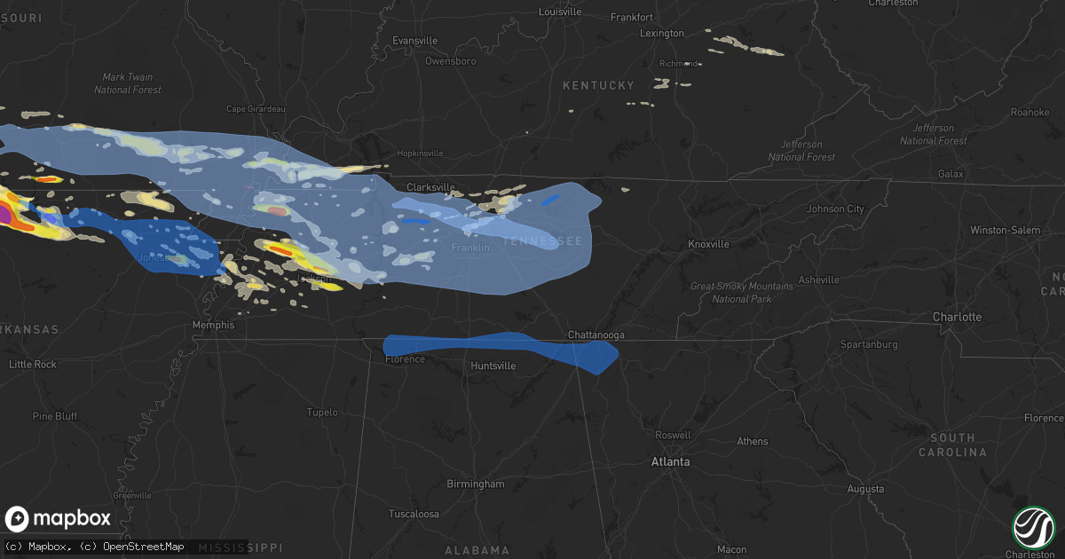
Hail Map in Tennessee on May 3, 2020
Get this storm
May 3 map
$229
one time, instant access
Download today. No call, no setup
Keep the $229
Bought the map and want the full workflow? Apply the entire $229 to a subscription within 7 days. None of it is wasted.
Every map, not just this one
This buys you this map. Subscription and you get every map we run, in the markets you choose from a few cities to whole states to nationwide. Plus real-time alerts the moment a storm fires.
Contact data
Name, contact info, occupancy, even credit band for addresses in the footprint. You go from where it hit to who to call.
Become the source they trust
Unlimited branding weather history reports on demand. You already have the documented answer ready for the property owner, and you are the one who showed up with it.
Property data and RoofTrace estimates
Pull up any address you have got, its value and the exact code rules for that jurisdiction, straight from One Click Code. Then RoofTrace estimates the squares, pitch, and roof value, priced the way you price.
Storm reports in Tennessee
Tennessee
| Date | Description |
|---|---|
| 05/03/20206:48 PM CDT | Tree down on home of nws employee. Numerous trees down in neighborhood |
| 05/03/20206:40 PM CDT | Large tree down on hwy 11. |
| 05/03/20206:40 PM CDT | 1 tree down on nashville highway in the lancing area. |
| 05/03/20206:40 PM CDT | Multiple trees down across the county. |
| 05/03/20206:34 PM CDT | Large tree uprooted. |
| 05/03/20206:30 PM CDT | Large hail up to ping pong size in oakfield. |
| 05/03/20206:28 PM CDT | Tree down on boston lane. |
| 05/03/20206:25 PM CDT | Trees and powerlines down on dayton mountain hwy. |
| 05/03/20206:25 PM CDT | Powerlines down on crabtree rd. |
| 05/03/20206:24 PM CDT | Tree on house on old peavine road in crossville |
| 05/03/20206:20 PM CDT | Tree on house on vandever road close to hwy 127 south |
| 05/03/20206:15 PM CDT | Tree on a house on vandever road near highway 127 s and tree on a house on old peavine road |
| 05/03/20206:11 PM CDT | Multiple trees down across northern marion county. |
| 05/03/20206:04 PM CDT | Multiple trees down in the county. |
| 05/03/20206:00 PM CDT | Tigrett grocery reported large hail some up to golf ball size. |
| 05/03/20206:00 PM CDT | Quarter size hail near glendale road and shae ln. |
| 05/03/20205:56 PM CDT | Ping pong ball size hail near crockett mills. |
| 05/03/20205:55 PM CDT | Half dollar and quarter sized hail in bonicord. |
| 05/03/20205:55 PM CDT | Trees down blocking greenbriar road and hilham highway at standing stone highway. Power lines down on carmack street. |
| 05/03/20205:50 PM CDT | Half dollar sized hail along the gibson and crockett county border. |
| 05/03/20205:50 PM CDT | Quarter sized hail on perry switch road. Started as pea sized hail. |
| 05/03/20205:50 PM CDT | Multiple reports of trees down across putnam county with power outages |
| 05/03/20205:50 PM CDT | Tigrett grocery reported large hail some up to golf ball size. |
| 05/03/20205:45 PM CDT | Half dollar and quarter sized hail in bonicord. |
| 05/03/20205:45 PM CDT | Multiple trees down near monteagle |
| 05/03/20205:40 PM CDT | Trees blown down in front of the courthouse |
| 05/03/20205:35 PM CDT | Mcminnville awos measured a wind gust of 52 knots / 60 mph |
| 05/03/20205:32 PM CDT | Estimated gusts of 60 mph... Lawn furniture displaced and damaged... And small tree limbs broken. |
| 05/03/20205:25 PM CDT | Destroyed shed on dog branch road |
| 05/03/20205:20 PM CDT | Barn destroyed in the hackett subdivision in tanglewood |
| 05/03/20205:18 PM CDT | Several trees down and buildings damaged in dixon springs |
| 05/03/20205:18 PM CDT | Widespread trees and power outages reported in the county. The most widespread damage was in northern franklin county. Roof damage reported at a residence on highway 12 |
| 05/03/20205:17 PM CDT | Multiple trees down in tullahoma |
| 05/03/20205:17 PM CDT | Numerous trees down on lock 7 lane |
| 05/03/20205:17 PM CDT | *** 2 inj *** numerous trees down with power outages across cannon county. Tree fell onto an atv injuring 2 people. |
| 05/03/20205:13 PM CDT | Numerous trees down and barn roofs blown off in the flat rock road at highway 70 area |
| 05/03/20205:10 PM CDT | A large tree was uprooted and knocked down. Report via social media. |
| 05/03/20205:05 PM CDT | Trees and power lines are down throughout the county. One tree was knocked onto a home. The gust front entered northwest moore county around 505 pm cdt and exited the s |
| 05/03/20205:04 PM CDT | Trees down. |
| 05/03/20205:02 PM CDT | Roof blown off title max store on madison street |
| 05/03/20205:00 PM CDT | Widespread wind damage....trees down and a barn damaged. |
| 05/03/20204:58 PM CDT | Numerous trees down in gallatin |
| 05/03/20204:55 PM CDT | Large trees down...wind gust estimation of 70 mph |
| 05/03/20204:54 PM CDT | Numerous trees down across mount juliet. Barn collapsed at 8485 lebanon road. |
| 05/03/20204:51 PM CDT | Tree fell onto a car on shute lane near brandywine |
| 05/03/20204:51 PM CDT | Smyrna airport asos measured a wind gust of 53 knots / 61 mph |
| 05/03/20204:50 PM CDT | Tree down on home of nws employee. Numerous trees down in neighborhood |
| 05/03/20204:50 PM CDT | Tree fell onto home on brookstone blvd in mount juliet causing major damage |
| 05/03/20204:49 PM CDT | Trees and power lines down throughout lincoln county power is out in about 1/2 of the county. The gust front entered northwest lincoln county around 449 pm and exiting |
| 05/03/20204:48 PM CDT | Tree on house in the bonnas neighborhood in hermitage |
| 05/03/20204:47 PM CDT | A local report indicates 62 MPH wind near NASHVILLE |
| 05/03/20204:46 PM CDT | *** 1 inj *** falling tree injured hiker near percy priest lake |
| 05/03/20204:45 PM CDT | On highway 412 a carport was blown into power lines. |
| 05/03/20204:44 PM CDT | Four corners marina was damaged as well as several boats |
| 05/03/20204:44 PM CDT | Nashville airport asos measured a wind gust of 62 knots / 71 mph |
| 05/03/20204:42 PM CDT | Brick garage wall collapsed in gum springs... Tn |
| 05/03/20204:41 PM CDT | Large tree fell on a house on mockingbird lane. |
| 05/03/20204:40 PM CDT | Tree down in yard of home of nws employee |
| 05/03/20204:40 PM CDT | Numerous trees and power lines down across the northern half of henderson county. |
| 05/03/20204:35 PM CDT | *** 1 fatal *** tree reportedly fell onto and killed a man near bethesda road at highway 431 |
| 05/03/20204:35 PM CDT | Multiple large trees down 1 mile north of concord rd and wilson pike intersection. 1 tree fell on a dog kennel...no dogs in the kennel at the time. |
| 05/03/20204:35 PM CDT | Historic 200 year old oak tree blown down at jt moore middle school |
| 05/03/20204:35 PM CDT | Numerous trees and power lines down across nashville. Over 130000 customers without power. |
| 05/03/20204:30 PM CDT | Numerous trees down and roof damage to homes in spring hill |
| 05/03/20204:30 PM CDT | Trees down in columbia...power out across much of the county. |
| 05/03/20204:30 PM CDT | Trees down in backyard of nws employee house |
| 05/03/20204:27 PM CDT | Numerous trees down on the natchez trace parkway blocking the road |
| 05/03/20204:20 PM CDT | Large tree uprooted on lonesome pine road. |
| 05/03/20204:19 PM CDT | Tree limbs down and power outages |
| 05/03/20204:18 PM CDT | Several trees down around clarksville |
| 05/03/20204:15 PM CDT | Trees down across waynesboro including at the golf course |
| 05/03/20204:15 PM CDT | Trees uprooted and power lines down on walnut grove road |
| 05/03/20204:10 PM CDT | Trees down on barker drive. |
| 05/03/20204:10 PM CDT | Roofs blown off several buildings and numerous trees down in hohenwald |
| 05/03/20204:08 PM CDT | Several trees down on pinewood road...oak springs road...and highway 100 |
| 05/03/20204:05 PM CDT | Tree down on vehicle. |
| 05/03/20204:05 PM CDT | Numerous reports of trees and power lines down with power outages across perry county |
| 05/03/20204:00 PM CDT | Numerous trees down and power outages throughout dickson county including on hummingbird lane. Tree on house at walnut grove road at yellow creek road |
| 05/03/20203:55 PM CDT | Portion of the roof removed at fisherdale marina. |
| 05/03/20203:51 PM CDT | Tree on a house on twin oaks road. Numerous trees down across western stewart county with appx 1000 people without power |
| 05/03/20203:50 PM CDT | Part of a metal roof pulled off home and numerous trees down across town. |
| 05/03/20203:49 PM CDT | Several trees down and outbuildings damaged around mcewen |
| 05/03/20203:45 PM CDT | Numerous trees down and power outages across houston county |
| 05/03/20203:45 PM CDT | Tree down over the road on hwy 22 near edge road... Eastside of chester co. |
| 05/03/20203:45 PM CDT | Utility pole snapped on 641 north of town and trees down across the community. |
| 05/03/20203:43 PM CDT | A local report indicates 70 MPH wind near DOVER |
| 05/03/20203:43 PM CDT | Power lines down and pole onto house on lankford lane. |
| 05/03/20203:41 PM CDT | Multiple trees down. |
| 05/03/20203:40 PM CDT | Numerous trees and power lines down across the northern half of henderson county. |
| 05/03/20203:39 PM CDT | Large tree on power lines |
| 05/03/20203:38 PM CDT | Trees down on highway 232 |
| 05/03/20203:37 PM CDT | Numerous trees and power poles snapped between paris and mckenzie |
| 05/03/20203:27 PM CDT | Multiple trees down. |
| 05/03/20203:26 PM CDT | Large tree down in town. |
| 05/03/20203:25 PM CDT | Multiple trees down and power lines snapped in half along with power outages in camden area and big sandy areas. All the county has trees down. |
| 05/03/20203:25 PM CDT | Davis weather unit reported 62 mph wind gust at 323 pm. |
| 05/03/20203:25 PM CDT | Power lines down and pole onto house on lankford lane. |
| 05/03/20203:20 PM CDT | 60 mph wind gust |
| 05/03/20203:20 PM CDT | Tree on house near jmc general hospital |
| 05/03/20203:20 PM CDT | Numerous trees and power poles snapped between paris and mckenzie |
| 05/03/20203:19 PM CDT | Several trees and powerlines down |
| 05/03/20203:18 PM CDT | Tree onto a house on ballywood |
| 05/03/20203:15 PM CDT | Tree across the road hwy 152 and christmasville rd |
| 05/03/20203:15 PM CDT | Four trees down at residence in three way. |
| 05/03/20203:14 PM CDT | 51 kt wind gust |
| 05/03/20203:10 PM CDT | Trees down at 54 and 190 near como. |
| 05/03/20203:09 PM CDT | Tree fallen on house on mt. Zion |
| 05/03/20203:09 PM CDT | Trees down in mckenzie |
| 05/03/20203:05 PM CDT | Multiple trees and powerlines down in the sharon and dresden areas. |
| 05/03/20203:05 PM CDT | Multiple trees and powerlines down. |
| 05/03/20203:00 PM CDT | Power lines blown down and blocking roads near the nissan car dealer in town. |
| 05/03/20202:50 PM CDT | Roof damage to an office building. |
| 05/03/20202:50 PM CDT | Large tree fell very close to home on n durham ave and another large tree fell in the yard of a home on maple street. Several large limbs blown off around area. |
| 05/03/20202:50 PM CDT | 5 miles n of martin tree limbs down and shingles blown off roof. |
| 05/03/20202:50 PM CDT | Numerous trees down across town. |
| 05/03/20202:50 PM CDT | Tree across the road in ripley near hwy 51 |
| 05/03/20202:45 PM CDT | Multiple trees and powerlines down. |
| 05/03/20202:39 PM CDT | 2 wsw martin numerous trees down and a shed with damage. |
| 05/03/20202:35 PM CDT | Trees down across south fulton. |
| 05/03/20202:35 PM CDT | Several trees down. |
| 05/03/20202:30 PM CDT | Real estate building roof blew off and onto the post office building with debris around and between buildings. The location washington ave and south 2nd. Trees down and |
| 05/03/20202:05 PM CDT | Large tree branches down in tiptonville. Winds estimated near 70 mph. |
| 05/03/20202:31 AM CDT | At 731 PM EDT, severe thunderstorms were located along a line extending from near Spring City to near Chickamauga, moving east at 55 mph. HAZARD...60 mph wind gusts. SOURCE...Radar indicated. IMPACT...Expect damage to roofs, siding, and trees. Locations impacted include... Cleveland, Athens, Sweetwater, Etowah, Charleston, South Cleveland, East Cleveland, Wildwood Lake, Englewood and Niota.This includes Interstate 75 in Tennessee between mile markers 16 and60. |
| 05/03/20202:12 AM CDT | At 712 PM EDT, a severe thunderstorm was located near Mount Pisgah, or 12 miles northeast of Jamestown, moving northeast at 40 mph. HAZARD...60 mph wind gusts and quarter size hail. SOURCE...Radar indicated. IMPACT...Hail damage to vehicles is expected. Expect wind damage to roofs, siding, and trees. This severe thunderstorm will be near... Great Meadows Campsites around 720 PM EDT. Blue Heron around 735 PM EDT. Whitley City around 745 PM EDT. |
| 05/03/20202:11 AM CDT | At 711 PM EDT, severe thunderstorms were located along a line extending from near Mount Pisgah to 11 miles south of Jamestown to 8 miles southwest of Crossville, moving east at 50 mph. HAZARD...60 mph wind gusts. SOURCE...Radar indicated. IMPACT...Expect damage to roofs, siding, and trees. Locations impacted include... Oak Ridge, Kingston, Rockwood, Loudon, Oneida, Wartburg, Fairview, Huntsville, Helenwood and Midtown.This includes Interstate 40 in Tennessee between mile markers 341 and363. |
| 05/03/20202:02 AM CDT | At 702 PM EDT, severe thunderstorms were located along a line extending from 9 miles southeast of Sparta to near Dunlap to near Bridgeport, moving east at 70 mph. HAZARD...60 mph wind gusts. SOURCE...Radar indicated. IMPACT...Expect damage to roofs, siding, and trees. Locations impacted include... Chattanooga, Dayton, Decatur, Soddy-Daisy, Signal Mountain, Spring City, Walden, Lakesite, Ridgeside and Fairmount.This includes Interstate 75 in Tennessee between mile markers 1 and15. |
| 05/03/20201:34 AM CDT | At 634 PM CDT, a severe thunderstorm was located near Blue Goose, or 10 miles east of Jackson, moving east at 50 mph. HAZARD...Quarter size hail. SOURCE...Radar indicated. IMPACT...Damage to vehicles is expected. Locations impacted include... Lexington, Parsons, Decaturville, Sardis, Reagan, Blue Goose, Darden, Bargerton, Montgomery, Scotts Hill, Cedar Grove, Beech Bluff, Haney, Rock Hill, Juno, Pleasant Grove, Mount Tabor, Middle Fork, Red Walnut and Timberlake. |
| 05/03/202012:54 AM CDT | At 554 PM CDT, a severe thunderstorm was located near Mifflin, or near Henderson, moving southeast at 45 mph. HAZARD...Quarter size hail. SOURCE...Radar indicated. IMPACT...Damage to vehicles is expected. Locations impacted include... Savannah, Henderson, Adamsville, Sardis, Reagan, Jacks Creek, Mifflin, Morris Chapel, Montgomery, Scotts Hill, Saltillo, Milledgeville, Enville, Pinson, Right, Beech Bluff, Phillips, Haney, Hinkle and Roby. |
| 05/03/202012:53 AM CDT | At 553 PM CDT, severe thunderstorms were located along a line extending from near Algood to 8 miles south of Spencer, moving east at 60 mph. HAZARD...60 mph wind gusts. SOURCE...Radar indicated. IMPACT...Expect damage to roofs, siding, and trees. Locations impacted include... Crossville, Sparta, Spencer, Fairfield Glade, Monterey, Crab Orchard, Pleasant Hill, Cumberland Mountain State Park, Slate Springs, Virgin Falls State Natural Area, Lake Tansi, Fall Creek Falls State Park and Indian Rock Lake.This includes Interstate 40 between mile markers 296 and 340. |
| 05/03/202012:44 AM CDT | At 544 PM CDT, severe thunderstorms were located along a line extending from 10 miles southeast of Smithville to 10 miles northwest of Gruetli-Laager to 8 miles south of Cowan, moving east at 65 mph. HAZARD...60 mph wind gusts. SOURCE...Radar indicated. IMPACT...Expect damage to roofs, siding, and trees. Locations impacted include... Dunlap, Jasper, Pikeville, Signal Mountain, South Pittsburg, Whitwell, Kimball, Monteagle, Fairmount and Powells Crossroads. |
| 05/03/202012:44 AM CDT | At 544 PM CDT, severe thunderstorms were located along a line extending from 7 miles north of Gruetli-Laager to near Monteagle, moving southeast at 55 mph. HAZARD...60 mph wind gusts. SOURCE...Radar indicated. IMPACT...Expect damage to roofs, siding, and trees. Locations impacted include... Gruetli-Laager, Tracy City, Monteagle, Altamont, Coalmont, Palmer, Beersheba Springs and Fiery Gizzard State Park.This includes Interstate 24 between mile markers 133 and 134. |
| 05/03/202012:41 AM CDT | At 540 PM CDT, severe thunderstorms were located along a line extending from near Monteagle to 7 miles southeast of New Market to Huntsville, moving east at 65 mph. HAZARD...70 mph wind gusts and penny size hail. SOURCE...Radar indicated. This storm has a history of producing widespread tree damage and power outages. IMPACT...Expect considerable tree damage. Damage is likely to mobile homes, roofs, and outbuildings. Locations impacted include... Huntsville, Scottsboro, Fort Payne, Winchester, Rainsville, Bridgeport, Moores Mill, Henagar, Stevenson and Sylvania. |
| 05/03/202012:25 AM CDT | At 525 PM CDT, a severe thunderstorm was located 7 miles northeast of Chestnut Bluff, or 10 miles southeast of Dyersburg, moving east at 60 mph. HAZARD...Quarter size hail. SOURCE...Radar indicated. IMPACT...Damage to vehicles is expected. Locations impacted include... Humboldt, Milan, Trenton, Fairview, Three Way, Atwood, Medina, Friendship, Gadsden, Gibson, Hickory Flat, Bishop, Hawkinsville, Quincy, Gibson Wells, Cades, New Enterprise, Bonicord, Central and Ledbetter. |
| 05/03/202012:18 AM CDT | At 517 PM CDT, severe thunderstorms were located along a line extending from 7 miles east of Watertown to 8 miles south of Woodbury, moving east at 60 mph. HAZARD...70 mph wind gusts. SOURCE...Radar indicated. IMPACT...Expect considerable tree damage. Damage is likely to mobile homes, roofs, and outbuildings. Locations impacted include... McMinnville, Sparta, Smithville, Woodbury, Spencer, Morrison, Doyle, Dowelltown, Liberty, Centertown, Bakers Crossroads, Rock Island State Park and Fall Creek Falls State Park.Warren County COVID-19 Mobile Testing Site will also be impacted. |
| 05/03/202012:06 AM CDT | At 506 PM CDT, severe thunderstorms were located along a line extending from 10 miles south of Murfreesboro to near Shelbyville to 9 miles west of Fayetteville, moving southeast at 70 mph. HAZARD...70 mph wind gusts and penny size hail. SOURCE...Radar indicated. IMPACT...Expect considerable tree damage. Damage is likely to mobile homes, roofs, and outbuildings. Locations impacted include... Shelbyville, Manchester, Tullahoma, Gruetli-Laager, Tracy City, Monteagle, Altamont, Coalmont, Morrison, Palmer, Wartrace, Bell Buckle, Beersheba Springs, Normandy, Viola, Beechgrove, Raus, Fosterville, Frankewing and Christiana.This includes the following highways... Interstate 65 between mile markers 15 and 20. Interstate 24 between mile markers 86 and 136. |
| 05/02/202011:49 PM CDT | At 448 PM CDT, severe thunderstorms were located along a line extending from near Nashville to near Brentwood to 6 miles east of Thompson's Station, moving east at 65 mph. HAZARD...70 mph wind gusts and penny size hail. SOURCE...Radar indicated. IMPACT...Expect considerable tree damage. Damage is likely to mobile homes, roofs, and outbuildings. Locations impacted include... Murfreesboro, Woodbury, Smyrna, La Vergne, Mount Juliet, Watertown, Walterhill, Rural Hill, Hickman, Alexandria, Dowelltown, Liberty, Auburntown, Lascassas, Cedars Of Lebanon State Park, Bradyville, Percy Priest Lake, Milton, Gladeville and Readyville. |
| 05/02/202011:41 PM CDT | At 440 PM CDT, severe thunderstorms were located along a line extending from near Nolensville to near Columbia to 10 miles northwest of Pulaski, moving southeast at 60 mph. HAZARD...60 mph wind gusts and penny size hail. SOURCE...Radar indicated. IMPACT...Expect damage to roofs, siding, and trees. Locations impacted include... Murfreesboro, Columbia, Shelbyville, Lewisburg, Spring Hill, Chapel Hill, Cornersville, Wartrace, Eagleville, Bell Buckle, Lynnville, Christiana, Culleoka, I-65 East Of Columbia, Fosterville, Rover, Belfast, Deason, Rockvale and Farmington. |
| 05/02/202011:17 PM CDT | At 417 PM CDT, severe thunderstorms were located along a line extending from near White Bluff to near Fairview to 8 miles east of Centerville, moving east at 60 mph. HAZARD...70 mph wind gusts and penny size hail. SOURCE...Radar indicated. IMPACT...Expect considerable tree damage. Damage is likely to mobile homes, roofs, and outbuildings. Locations impacted include... Franklin, Columbia, Smyrna, Brentwood, La Vergne, Spring Hill, Nolensville, Forest Hills, Oak Hill, Belle Meade, Kingston Springs, Thompson's Station, Pegram, Fairview, Bellevue, Antioch, Rural Hill, Eagleville, Berry Hill and Primm Springs. |
| 05/02/202011:12 PM CDT | At 412 PM CDT, severe thunderstorms were located along a line extending from 6 miles south of Centerville to near Hohenwald to 10 miles northeast of Olive Hill, moving east at 60 mph. HAZARD...70 mph wind gusts and penny size hail. SOURCE...Radar indicated. IMPACT...Expect considerable tree damage. Damage is likely to mobile homes, roofs, and outbuildings. Locations impacted include... Columbia, Lawrenceburg, Hohenwald, Waynesboro, Mount Pleasant, Summertown, Ethridge, Gordonsburg, Kimmins, Henryville, Culleoka, Hampshire and Williamsport.This includes Interstate 65 between mile markers 36 and 44. |
| 05/02/202011:10 PM CDT | At 410 PM CDT, a severe thunderstorm was located over Lakeland, or near Bartlett, moving east at 55 mph. HAZARD...60 mph wind gusts and quarter size hail. SOURCE...Radar indicated. IMPACT...Hail damage to vehicles is expected. Expect wind damage to roofs, siding, and trees. Locations impacted include... Bartlett, Millington, Lakeland, Arlington, Somerville, Ellendale, Eads, Warren, Macon, Oakland, Gallaway, Williston, Braden, Lenow, Yum Yum, Taylor Chapel, Rosemark, Hickory Withe, Pattersonville and Elmore Park. |
| 05/02/202010:54 PM CDT | At 354 PM CDT, severe thunderstorms were located along a line extending from 8 miles southeast of Erin to 6 miles south of McEwen to 8 miles south of Hurricane Mills, moving east at 45 mph. HAZARD...70 mph wind gusts and penny size hail. SOURCE...Radar indicated. IMPACT...Expect considerable tree damage. Damage is likely to mobile homes, roofs, and outbuildings. Locations impacted include... Dickson, Centerville, White Bluff, Kingston Springs, Pegram, McEwen, Burns, Fairview, Charlotte, Bon Aqua, Primm Springs, Lyles, Bucksnort, Pinewood and Nunnelly.This includes the following highways... Interstate 40 between mile markers 147 and 190. Interstate 840 between mile markers 1 and 12. |
| 05/02/202010:37 PM CDT | At 337 PM CDT, severe thunderstorms were located along a line extending from 8 miles south of New Johnsonville to near Mifflin, moving east at 65 mph. HAZARD...60 mph wind gusts and nickel size hail. SOURCE...Radar indicated. IMPACT...Expect damage to roofs, siding, and trees. Locations impacted include... Hohenwald, Waynesboro, Linden, Lobelville, Gordonsburg, Kimmins, Mousetail Landing State Park, Pleasantville and Flatwoods. |
| 05/02/202010:35 PM CDT | At 335 PM CDT, severe thunderstorms were located along a line extending from near New Johnsonville to near Lexington to near Whiteville, moving east at 60 mph. HAZARD...70 mph wind gusts and quarter size hail. SOURCE...Radar indicated. IMPACT...Hail damage to vehicles is expected. Expect considerable tree damage. Wind damage is also likely to mobile homes, roofs, and outbuildings. Locations impacted include... Lexington, Savannah, Henderson, Bolivar, Selmer, Camden, Natchez Trace State Park, Chickasaw State Park, Natchez Trace State Forest, Chickasaw State Forest, Parsons, Adamsville, New Johnsonville, Decaturville, Sardis, Silerton, Masseyville, Reagan, Jacks Creek and Mifflin. |
| 05/02/202010:22 PM CDT | At 321 PM CDT, severe thunderstorms were located along a line extending from near Paris to Vale to Huntingdon, moving east at 65 mph. HAZARD...70 mph wind gusts and penny size hail. SOURCE...Radar indicated. IMPACT...Expect considerable tree damage. Damage is likely to mobile homes, roofs, and outbuildings. Locations impacted include... Dickson, Waverly, Camden, New Johnsonville, McEwen, Hurricane Mills, Vanleer and Bucksnort.This includes Interstate 40 between mile markers 136 and 164. |
| 05/02/202010:13 PM CDT | At 312 PM CDT, severe thunderstorms were located along a line extending from near Murray to 12 miles northwest of Paris Landing State Park to near Paris, moving east at 70 mph. HAZARD...70 mph wind gusts and penny size hail. SOURCE...Radar indicated. IMPACT...Expect considerable tree damage. Damage is likely to mobile homes, roofs, and outbuildings. Locations impacted include... Dover, Erin, Tennessee Ridge, Big Rock, Cumberland City, Land Between The Lakes, Houston County Airport and Indian Mound. |
| 05/02/202010:10 PM CDT | At 310 PM CDT, severe thunderstorms were located along a line extending from near Huntingdon to near Adair to 6 miles northeast of Arlington, moving east at 55 mph. HAZARD...70 mph wind gusts and quarter size hail. SOURCE...Radar indicated. IMPACT...Hail damage to vehicles is expected. Expect considerable tree damage. Wind damage is also likely to mobile homes, roofs, and outbuildings. Locations impacted include... Jackson, Brownsville, Humboldt, Milan, Lexington, Henderson, Bolivar, Huntingdon, Camden, Natchez Trace State Park, Chickasaw State Park, Natchez Trace State Forest, Chickasaw State Forest, Fairview, Whiteville, Three Way, Bruceton, Atwood, Silerton and Masseyville. |
| 05/02/202010:06 PM CDT | At 306 PM CDT, severe thunderstorms were located along a line extending from 7 miles southwest of Benton to near Murray to 10 miles northeast of Cottage Grove, moving east at 65 mph. HAZARD...70 mph wind gusts. SOURCE...Radar indicated. IMPACT...Expect considerable tree damage. Damage is likely to mobile homes, roofs, and outbuildings. Locations impacted include... Land Between The Lakes Area, Linton and New Concord. |
| 05/02/20209:48 PM CDT | At 247 PM CDT, severe thunderstorms were located along a line extending from 9 miles southwest of Dyer to near Wilson, moving east at 45 mph. HAZARD...70 mph wind gusts and quarter size hail. SOURCE...Radar indicated. IMPACT...Hail damage to vehicles is expected. Expect considerable tree damage. Wind damage is also likely to mobile homes, roofs, and outbuildings. Locations impacted include... Brownsville, Millington, Covington, Humboldt, Ripley, Milan, Trenton, Lakeland, Arlington, Munford, Brighton, Alamo, Bells, Halls, Chestnut Bluff, Dixonville, Nutbush, Forked Deer, Belle Eagle and Holly Grove. |
| 05/02/20209:29 PM CDT | At 228 PM CDT, severe thunderstorms were located along a line extending from 6 miles south of Horseshoe Lake Conservation Area to Wyatt to 8 miles northeast of Towosahgy State Historic Site to near Clinton to near Union City, moving east at 55 mph. HAZARD...70 mph wind gusts and penny size hail. SOURCE...Radar indicated. IMPACT...Expect considerable tree damage. Damage is likely to mobile homes, roofs, and outbuildings. Locations impacted include... Murray, Mayfield, Benton, Lynnville, Sedalia, Wingo, Hardin, Hazel, Water Valley, Lowes, Fancy Farm, Kirksey, Brewers, Dukedom, Harris Grove, Symsonia and Crossland.This includes Interstate 69 in Kentucky between Mile Markers 9 and44. |
| 05/02/20209:09 PM CDT | At 208 PM CDT, severe thunderstorms were located along a line extending from near Clayton to near Gosnell, moving east at 55 mph. HAZARD...70 mph wind gusts and quarter size hail. SOURCE...Radar indicated. IMPACT...Hail damage to vehicles is expected. Expect considerable tree damage. Wind damage is also likely to mobile homes, roofs, and outbuildings. Locations impacted include... Dyersburg, Blytheville, Martin, Union City, Caruthersville, Gosnell, Hayti, Fulton, Steele, Reelfoot Lake State Park, Tiptonville, Newbern, South Fulton, Ridgely, Troy, Kenton, Obion, Hornersville, Hayti Heights and Cooter. |
| 05/02/20209:08 PM CDT | At 207 PM CDT, severe thunderstorms were located along a line extending from near Advance to near Hay-Wood City to near East Prairie to near Farrenburg to near Tiptonville, moving east at 50 mph. HAZARD...70 mph wind gusts and nickel size hail. SOURCE...Radar indicated. IMPACT...Expect considerable tree damage. Damage is likely to mobile homes, roofs, and outbuildings. Locations impacted include... Charleston, East Prairie, Cairo, Fulton, Hickman, Clinton, Oran, Benton, Bardwell, Wickliffe, Towosahgy State Historic Site, Big Oak Tree State Park, Bertrand, Morley, Wyatt, Anniston, Cayce, Dorena, Fulgham and Hay-Wood City.This includes the following highways... Interstate 57 in Illinois between Mile Markers 1 and 3. Interstate 57 in Missouri between Mile Markers 4 and 21. Interstate 69 in Kentucky between Mile Markers 1 and 8. Interstate 55 between Mile Markers 72 and 81. |
All States Impacted by Hail Map on May 3, 2020
Cities Impacted by Hail Map on May 3, 2020
- Wray, CO
- Eckley, CO
- Haigler, NE
- Westport, TN
- Osceola, AR
- Valley Springs, AR
- Pyatt, AR
- Harrison, AR
- Summit, AR
- Melbourne, AR
- Flippin, AR
- Norfork, AR
- Theodosia, MO
- Calico Rock, AR
- Lead Hill, AR
- Protem, MO
- Yellville, AR
- Rueter, MO
- Peel, AR
- Ravenden, AR
- Ravenden Springs, AR
- Somerville, TN
- Chapman, KS
- Enterprise, KS
- Solomon, KS
- Abilene, KS
- Sturgis, SD
- Mayfield, KY
- Clinton, KY
- Kirksey, KY
- Almo, KY
- Murray, KY
- Wingo, KY
- Fulton, KY
- Sedalia, KY
- Farmington, KY
- Limon, CO
- Elbert, CO
- Sterling, CO
- Merino, CO
- Toronto, KS
- Virgil, KS
- Yates Center, KS
- Bronte, TX
- Gypsum, KS
- Big Springs, NE
- Chappell, NE
- Bon Aqua, TN
- Dickson, TN
- Mount Juliet, TN
- Madison, TN
- Old Hickory, TN
- Hermitage, TN
- Nashville, TN
- Upton, WY
- Fremont, MO
- Birch Tree, MO
- Van Buren, MO
- Grandin, MO
- Eminence, MO
- Winona, MO
- Poplar Bluff, MO
- Ellsinore, MO
- Kilgore, NE
- Cody, NE
- Nenzel, NE
- Galesburg, KS
- West Plains, MO
- Purcell, MO
- Jasper, MO
- Carthage, MO
- Alba, MO
- Oronogo, MO
- Webb City, MO
- Atwood, KS
- McDonald, KS
- Henderson, TN
- Luray, TN
- Jacks Creek, TN
- Beech Bluff, TN
- Pinson, TN
- Jackson, TN
- Vernon, CO
- Yuma, CO
- Kimberling City, MO
- Shell Knob, MO
- Lampe, MO
- Blue Eye, MO
- Branson, MO
- Reeds Spring, MO
- Kirbyville, MO
- Ridgedale, MO
- Hollister, MO
- Fort Scott, KS
- Fulton, KS
- Reeds, MO
- Stotts City, MO
- Avilla, MO
- Sarcoxie, MO
- La Russell, MO
- Walnut Ridge, AR
- Lebanon, TN
- Castalian Springs, TN
- Gallatin, TN
- Marathon, TX
- Akron, CO
- Stanton, TN
- Brownsville, TN
- Henning, TN
- Blytheville, AR
- Atoka, TN
- Luxora, AR
- Brighton, TN
- Covington, TN
- Mason, TN
- Ripley, TN
- Burlison, TN
- Gill, CO
- Fredonia, KS
- Scammon, KS
- McCune, KS
- West Mineral, KS
- Mindenmines, MO
- Arma, KS
- Frontenac, KS
- Pittsburg, KS
- Weir, KS
- Asbury, MO
- Girard, KS
- Cherokee, KS
- Franklin, KS
- Greensburg, KY
- Cottontown, TN
- Portland, TN
- White House, TN
- Dyersburg, TN
- Huntingdon, TN
- Atwood, TN
- Wanblee, SD
- Elsie, NE
- Julesburg, CO
- Grant, NE
- Wauneta, NE
- Madrid, NE
- Hayes Center, NE
- Venango, NE
- Imperial, NE
- Dyer, TN
- Buffalo, SD
- Colby, KS
- Batavia, OH
- Smithville, AR
- Wiggins, CO
- Brush, CO
- Delaplaine, AR
- Mertzon, TX
- Hamilton, KS
- East Prairie, MO
- Parks, NE
- Holcomb, MO
- Carlsbad, TX
- Robert Lee, TX
- Black Hawk, SD
- Piedmont, SD
- Kyle, SD
- Long Valley, SD
- Box Elder, SD
- Saint Francis, SD
- Deadwood, SD
- Tuthill, SD
- Martin, SD
- Interior, SD
- Rapid City, SD
- Ellsworth Afb, SD
- New Underwood, SD
- Norris, SD
- Wall, SD
- Scenic, SD
- Caputa, SD
- Flagler, CO
- Hugo, CO
- Seibert, CO
- Simla, CO
- Genoa, CO
- Arriba, CO
- Matheson, CO
- Waverly, TN
- Ogallala, NE
- Ramah, CO
- Calhan, CO
- Martin, TN
- Oakfield, TN
- Broseley, MO
- Denmark, TN
- West Liberty, KY
- Jonesboro, AR
- Lake City, AR
- Bay, AR
- Jordan, MT
- Fort Meade, SD
- Whitewood, SD
- Troy, TN
- Rives, TN
- Hornbeak, TN
- Ridgely, TN
- Obion, TN
- Wellington, KS
- Dudley, MO
- Wappapello, MO
- Williamsville, MO
- Puxico, MO
- Fisk, MO
- Jerico Springs, MO
- Latham, KS
- Dora, MO
- Omaha, AR
- Goodlettsville, TN
- Hendersonville, TN
- Kanorado, KS
- Bethune, CO
- Stratton, CO
- Burlington, CO
- Aurora, MO
- Lobelville, TN
- Hurricane Mills, TN
- Woodrow, CO
- Humboldt, TN
- Alamo, TN
- Gadsden, TN
- Medina, TN
- Friendship, TN
- Lexington, TN
- Blackwell, TX
- Lawrenceburg, IN
- Harrison, OH
- North Bend, OH
- Doniphan, MO
- Pocahontas, AR
- Imboden, AR
- Summersville, MO
- Russell, KS
- Dorrance, KS
- Bunker Hill, KS
- Hartville, MO
- Marshfield, MO
- Niangua, MO
- Stoneham, CO
- Caulfield, MO
- Miller, MO
- Rector, AR
- Boyes, MT
- Willow Springs, MO
- Crane, MO
- Fleming, CO
- Atwood, CO
- Goodland, KS
- Whites Creek, TN
- Whiteville, TN
- Orchard, CO
- Alzada, MT
- Briggsdale, CO
- Fort Morgan, CO
- Salina, KS
- Benedict, KS
- Chanute, KS
- Belle Fourche, SD
- Hammond, MT
- Lemoyne, NE
- Lewellen, NE
- Essex, MO
- Agate, CO
- Decker, MT
- Wingate, TX
- Tuscola, TX
- Worden, MT
- Keystone, NE
- Paxton, NE
- Humboldt, KS
- Buffalo, KS
- Madison, KS
- Eureka, KS
- Piqua, KS
- Erie, KS
- Sylvan Grove, KS
- Wilson, KS
- Buena Vista, TN
- Abilene, TX
- Merkel, TX
- Keystone, SD
- Hill City, SD
- Custer, SD
- Hermosa, SD
- Columbus, KY
- Matthews, MO
- Ash Grove, MO
- Bois D Arc, MO
- Champion, NE
- Joelton, TN
- Whitman, NE
- Hyannis, NE
- Neck City, MO
- De Mossville, KY
- Butler, KY
- Highlandville, MO
- Galena, MO
- Clever, MO
- Billings, MO
- Walnut Grove, MO
- Aldrich, MO
- Morrisville, MO
- Bolivar, MO
- Lance Creek, WY
- Cabool, MO
- Snyder, CO
- Max, NE
- Benkelman, NE
- Cherryvale, KS
- Neodesha, KS
- Elk City, KS
- Independence, KS
- Republican City, NE
- Springfield, MO
- Willard, MO
- Fancy Farm, KY
- Dexter, KY
- Cincinnati, OH
- Osage City, KS
- Saint Paul, KS
- Walnut, KS
- Trenton, TN
- Maynard, AR
- Corning, AR
- Biggers, AR
- Ballinger, TX
- Winters, TX
- Danforth, ME
- Moundville, MO
- Uniontown, KS
- Arcadia, KS
- Garland, KS
- Bronaugh, MO
- Buffalo Gap, TX
- Volborg, MT
- Monett, MO
- Marionville, MO
- Columbus, KS
- Pierce City, MO
- Carl Junction, MO
- Nixa, MO
- Ozark, MO
- Golden City, MO
- Freistatt, MO
- Galena, KS
- Mount Vernon, MO
- Verona, MO
- Wentworth, MO
- Tiptonville, TN
- Pontiac, MO
- Midway, AR
- Everton, AR
- Cape Fair, MO
- Cotter, AR
- Cedarcreek, MO
- Oxford, AR
- Brockwell, AR
- Viola, AR
- Pineville, AR
- Elizabeth, AR
- Salem, AR
- Gassville, AR
- Golden, MO
- Oakland, AR
- Sage, AR
- Franklin, AR
- Wideman, AR
- Dolph, AR
- Bexar, AR
- Mountain Home, AR
- Lakeview, AR
- Cassville, MO
- Bull Shoals, AR
- Altamont, KS
- Parsons, KS
- Pottersville, MO
- Otter, MT
- Norman, IN
- Liberal, MO
- Paragould, AR
- Cumberland Furnace, TN
- Vanleer, TN
- Weldona, CO
- Cheyenne, WY
- Allen, SD
- Byers, CO
- Ashland City, TN
- Sikeston, MO
- Bloomfield, MO
- Dexter, MO
- Forsyth, MO
- Rockaway Beach, MO
- Taneyville, MO
- Longton, KS
- Otis, CO
- Heltonville, IN
- Bedford, IN
- Vona, CO
- Fordland, MO
- Seymour, MO
- Broadwater, NE
- Brownstown, IN
- Medora, IN
- Redfield, KS
- Severy, KS
- Fall River, KS
- Gates, TN
- Howard, KS
- Knobel, AR
- Warm Springs, AR
- Peach Orchard, AR
- Success, AR
- Purdy, MO
- Salyersville, KY
- Wiseman, AR
- Glencoe, AR
- Ash Flat, AR
- Horseshoe Bend, AR
- Arthur, NE
- Tryon, NE
- Colony, KS
- Westphalia, KS
- McKee, KY
- Mount Vernon, KY
- Berea, KY
- Charlotte, TN
- Moody, MO
- Tecumseh, MO
- Beaver City, NE
- Mountain View, MO
- Nunnelly, TN
- Only, TN
- Lyles, TN
- Duck River, TN
- Centerville, TN
- Bradford, TN
- Piedmont, KS
- Beaumont, KS
- Leon, KS
- Iola, KS
- Union City, TN
- Hay Springs, NE
- Blue Mound, KS
- Mapleton, KS
- Mound City, KS
- Lancaster, KY
- Datto, AR
- Greenfield, MO
- Alicia, AR
- Portia, AR
- Hoxie, AR
- Wildersville, TN
- Darden, TN
- Commiskey, IN
- Hartsville, TN
- Linden, TN
- Denniston, KY
- Wellington, KY
- Ezel, KY
- Frenchburg, KY
- Salt Lick, KY
- Gepp, AR
- Medon, TN
- Mercer, TN
- Grover, CO
- Chadwick, MO
- Chestnutridge, MO
- Ponce De Leon, MO
- Lockwood, MO
- Sparta, MO
- South Greenfield, MO
- Everton, MO
- Republic, MO
- Oldfield, MO
- Spokane, MO
- Cedar Grove, TN
- Clifton, TN
- Madison, IN
- Florence, IN
- Bennington, IN
- Vevay, IN
- Stratton, NE
- Winchester, OH
- Brentwood, TN
- Mount Orab, OH
- Sardinia, OH
- Oswego, KS
- Cottage Grove, TN
- Paris, TN
- Erin, TN
- Holladay, TN
- Ovalo, TX
- Lawn, TX
- Huron, TN
- Reagan, TN
- Newcastle, WY
- Trenton, NE
- Talpa, TX
- Oberlin, KS
- Herndon, KS
- Kenton, TN
- Broadus, MT
- Cadiz, KY
- Mount Sterling, KY
- Orleans, NE
- Alma, NE
- Camden, TN
- Brule, NE
- Exeter, MO
- Norwood, MO
- Big Lake, TX
- Mound Valley, KS
- Sidney, AR
- Verona, KY
- Warsaw, KY
- Deputy, IN
- Paris Crossing, IN
- Piggott, AR
- Saint Francis, AR
- Campbell, MO
- Rogersville, MO
- Haxtun, CO
- Sedgwick, CO
- Bells, TN
- Halls, TN
- Milan, TN
- Water Valley, KY
- Keenesburg, CO
- Springfield, TN
- Chapmansboro, TN
- Cedar Hill, TN
- Pleasant View, TN
- Brookland, AR
- Sturkie, AR
- Thornfield, MO
- New Concord, KY
- Clyde, TX
- Oxly, MO
- Naylor, MO
- Leachville, AR
- Monette, AR
- Dell, AR
- Manila, AR
- Pleasanton, KS
- Bruner, MO
- Clarksville, TN
- Sunman, IN
- Milan, IN
- Deer Trail, CO
- Greeley, CO
- Hardy, AR
- Etowah, AR
- Lavinia, TN
- Duenweg, MO
- Diamond, MO
- Joplin, MO
- Black Oak, AR
- Caraway, AR
- Mammoth Spring, AR
- Scotts Hill, TN
- Sardis, TN
- Portageville, MO
- Greenfield, TN
- Rutherford, TN
- Parsons, TN
- Decaturville, TN
- Trezevant, TN
- Finley, TN
- Lincoln, KS
- Bolivar, TN
- Toone, TN
- La Harpe, KS
- Moran, KS
- Cherokee Village, AR
- Richmond, KY
- Irvine, KY
- Guilford, IN
- Stanton, KY
- Cardwell, MO
- Arbyrd, MO
- Houston, MO
- Elk Creek, MO
- Solo, MO
- Graff, MO
- Mountain Grove, MO
- Hillrose, CO
- Gainesville, MO
- Roggen, CO
- Nevada, MO
- Bono, AR
- Palmersville, TN
- Burns, TN
- Clay City, KY
- Wilson, AR
- Catron, MO
- Hickman, KY
- Bertrand, MO
- Charleston, MO
- Arlington, KY
- New Madrid, MO
- Bethpage, TN
- Westmoreland, TN
- State University, AR
- Smiths Grove, KY
- Henry, TN
- Coffeyville, KS
- Bartlett, KS
- Atlanta, KS
- Liberty, KS
- Augusta, KS
- Edna, KS
- Eubank, KY
- Waynesburg, KY
- Franklin, TN
- Hayti, MO
- Bragg City, MO
- Wardell, MO
- Devils Tower, WY
- Hazel, KY
- Buchanan, TN
- Wytopitlock, ME
- Poughkeepsie, AR
- Cave City, AR
- Powersite, MO
- Evening Shade, AR
- Mount Pleasant, AR
- Gamaliel, AR
- Bradleyville, MO
- Dyess, AR
- Pall Mall, TN
- Jamestown, TN
- Bird City, KS
- Williamsburg, OH
- Dadeville, MO
- Middleburg, KY
- Kings Mountain, KY
- Paint Lick, KY
- Stanford, KY
- Crab Orchard, KY
- Kincaid, KS
- Welda, KS
- Springville, IN
- Mize, KY
- Liberty, KY
- Arlington, TN
- Black Rock, AR
- Powhatan, AR
- Seymour, IN
- Neosho Falls, KS
- Gridley, KS
- Ellsworth, KS
- Elizabeth, CO
- Oshkosh, NE
- Lodgepole, NE
- Sidney, NE
- Bronson, KS
- Hartsville, IN
- Columbus, IN
- Beech Grove, AR
- Merom, IN
- Carlisle, IN
- Greenbrier, TN
- Marmaduke, AR
- Means, KY
- Jeffersonville, KY
- Nemo, SD
- Fairburn, SD
- Capitol, MT
- Wibaux, MT
- Sentinel Butte, ND
- Beach, ND
- Kissee Mills, MO
- Brighton, MO
- Harbeson, DE
- Rehoboth Beach, DE
- Millsboro, DE
- Lewes, DE
- Lamar, MO
- Arcola, MO
- Stockton, MO
- Walnut Shade, MO
- Shelbyville, TN
- Gleason, TN
- Hickman, TN
- Carthage, TN
- Hilham, TN
- Whitleyville, TN
- Hampshire, TN
- Auburntown, TN
- Woodbury, TN
- Clarkton, MO
- Manchester, TN
- Pollard, AR
- Macomb, MO
- Buffalo Valley, TN
- Mount Pleasant, TN
- Morrison, TN
- Culleoka, TN
- Beechgrove, TN
- Brandsville, MO
- Mill Spring, MO
- Southside, TN
- Smithville, TN
- Indian Mound, TN
- Readyville, TN
- Big Sandy, TN
- Rickman, TN
- Bardwell, KY
- Steele, MO
- Granville, TN
- Zalma, MO
- College Grove, TN
- Lewisburg, TN
- Normandy, TN
- Watertown, TN
- Squires, MO
- Sharon, TN
- Fairview, TN
- Cumberland City, TN
- Qulin, MO
- Greenville, MO
- Lascassas, TN
- Primm Springs, TN
- Kennett, MO
- Williamsport, TN
- Pomona, MO
- Spencer, TN
- Hohenwald, TN
- Lafayette, TN
- Bernie, MO
- Neelyville, MO
- Sugar Tree, TN
- La Vergne, TN
- Couch, MO
- Newbern, TN
- Fairdealing, MO
- Stewart, TN
- Kingston Springs, TN
- Doyle, TN
- Gordonsville, TN
- Chapel Hill, TN
- Spring Hill, TN
- Milton, TN
- Alexandria, TN
- Eva, TN
- McKenzie, TN
- Murfreesboro, TN
- Smyrna, TN
- Bradyville, TN
- Columbia, TN
- Bell City, MO
- Drury, MO
- Walling, TN
- Silver Point, TN
- Gideon, MO
- Cookeville, TN
- Antioch, TN
- Moss, TN
- Palmyra, TN
- Sturdivant, MO
- Harviell, MO
- Elmwood, TN
- Celina, TN
- Koshkonong, MO
- Rockvale, TN
- Rock Island, TN
- Canalou, MO
- Bell Buckle, TN
- Quebeck, TN
- Hollow Rock, TN
- Pleasant Shade, TN
- Dover, TN
- Dowelltown, TN
- Parma, MO
- Yuma, TN
- Mcminnville, TN
- Oran, MO
- Bloomington Springs, TN
- Trimble, TN
- Baxter, TN
- Wartrace, TN
- Woodlawn, TN
- Mansfield, MO
- Advance, MO
- Gibson, MO
- McGee, MO
- Christiana, TN
- Vanzant, MO
- Malden, MO
- Greenway, AR
- Liberty, TN
- Lancaster, TN
- Brush Creek, TN
- Puryear, TN
- Livingston, TN
- Thayer, MO
- White Bluff, TN
- McEwen, TN
- Peace Valley, MO
- Springville, TN
- Arrington, TN
- Allons, TN
- Thompsons Station, TN
- Riddleton, TN
- Gainesboro, TN
- Alton, MO
- Pegram, TN
- Eagleville, TN
- Dukedom, TN
- Dresden, TN
- Caruthersville, MO
- Nolensville, TN
- Bruceton, TN
- Lilbourn, MO
- Santa Fe, TN
- Dixon Springs, TN
- Marston, MO
- South Fulton, TN
- Unionville, TN
- Ava, MO
- Piedmont, MO
- Tennessee Ridge, TN
- Sparta, TN
- Chestnut Mound, TN
- Cunningham, TN
- Vanduser, MO
- Red Boiling Springs, TN
- Anniston, MO
- New Johnsonville, TN
- Mansfield, TN
- Lynn, AR
- Williford, AR
- Weiner, AR
- O'Kean, AR
- Violet Hill, AR
- Lafe, AR
- Cash, AR
- Hornersville, MO
- Trumann, AR
- Keiser, AR
- Swifton, AR
- Marked Tree, AR
- Lepanto, AR
- Harrisburg, AR
- Lookout Mountain, GA
- Flintville, TN
- Ardmore, TN
- Killen, AL
- Toney, AL
- Elkmont, AL
- Ringgold, GA
- Rock Spring, GA
- Stevenson, AL
- Menlo, GA
- Waterloo, AL
- Tunnel Hill, GA
- Lester, AL
- Higdon, AL
- Huntland, TN
- Hollywood, AL
- New Market, AL
- Fackler, AL
- Ider, AL
- La Fayette, GA
- Rogersville, AL
- Anderson, AL
- Rocky Face, GA
- Meridianville, AL
- Rossville, GA
- Estillfork, AL
- Chickamauga, GA
- Trenton, GA
- Saint Joseph, TN
- Minor Hill, TN
- Kelso, TN
- Wildwood, GA
- Fort Oglethorpe, GA
- Flat Rock, AL
- Elora, TN
- Five Points, TN
- Fayetteville, TN
- Hazel Green, AL
- Bryant, AL
- Taft, TN
- Pisgah, AL
- Florence, AL
- Prospect, TN
- Scottsboro, AL
- Trion, GA
- Cypress Inn, TN
- Bridgeport, AL
- Rising Fawn, GA
- Ardmore, AL
- Loretto, TN
- Lutts, TN
- Iron City, TN
- Flintstone, GA
- Athens, AL
- Lexington, AL
- King George, VA
- Elsmore, KS
- Chetopa, KS
- Iliff, CO
- Kiowa, CO
- Bennett, CO


