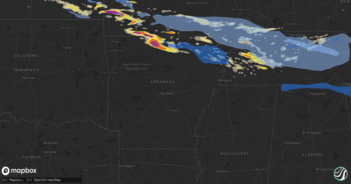
Hail Map in Arkansas on May 3, 2020
Get this storm
May 3 map
$229
one time, instant access
Download today. No call, no setup
Keep the $229
Bought the map and want the full workflow? Apply the entire $229 to a subscription within 7 days. None of it is wasted.
Every map, not just this one
This buys you this map. Subscription and you get every map we run, in the markets you choose from a few cities to whole states to nationwide. Plus real-time alerts the moment a storm fires.
Contact data
Name, contact info, occupancy, even credit band for addresses in the footprint. You go from where it hit to who to call.
Become the source they trust
Unlimited branding weather history reports on demand. You already have the documented answer ready for the property owner, and you are the one who showed up with it.
Property data and RoofTrace estimates
Pull up any address you have got, its value and the exact code rules for that jurisdiction, straight from One Click Code. Then RoofTrace estimates the squares, pitch, and roof value, priced the way you price.
Storm reports in Arkansas
Arkansas
| Date | Description |
|---|---|
| 05/03/20202:49 PM CDT | Powerlines down at the intersection of hwy 18 and hwy 312 between dell and gosnell |
| 05/03/20202:44 PM CDT | Trees damaged and powerlines down near mockingbird lane |
| 05/03/20202:10 PM CDT | Hail to 1 inch reported by trained spotter. |
| 05/03/20202:02 PM CDT | Tree down on sage meadows golf course. |
| 05/03/20202:00 PM CDT | Wind gust of 60mph reported by law enforcement. |
| 05/03/20201:50 PM CDT | 4 miles northest of jonesboro carport damaged. |
| 05/03/20201:45 PM CDT | Tree down on highway 141 near ebenezer. |
| 05/03/20201:45 PM CDT | A few trees down in rector... Clay co. |
| 05/03/20201:40 PM CDT | Numerous trees down across town. |
| 05/03/20201:30 PM CDT | A large tree was blown over near the evening shade steam engine. |
| 05/03/20201:25 PM CDT | Personal weather station measured a 61 mph wind gust. |
| 05/03/20201:20 PM CDT | Quarter size hail in sidney... Ar. |
| 05/03/20201:20 PM CDT | Tree down on powerlines on sw 3rd |
| 05/03/20201:17 PM CDT | Utility pole snapped along county road 140. |
| 05/03/20201:02 PM CDT | Social media video of quarter size hail in melbourne. |
| 05/03/202012:45 PM CDT | A local report indicates 1.25 inch wind near 1 SW CALICO ROCK |
| 05/03/202012:30 PM CDT | A local report indicates 2.00 inch wind near 2 S NORFORK |
| 05/03/202012:26 PM CDT | Public report of tennis ball sized hail. |
| 05/03/202012:08 PM CDT | Numerous trees blown down across the western portions of the county... Some blocking roads. A school building sustained minor damage. |
| 05/03/202012:08 PM CDT | A local report indicates 1.75 inch wind near YELLVILLE |
| 05/03/202012:00 PM CDT | One inch hail was reported at the baxter regional hospital. |
| 05/03/202011:54 AM CDT | Public report of golf ball sized hail in midway. |
| 05/03/202011:53 AM CDT | A local report indicates 1.50 inch wind near 3 NW MOUNTAIN HOME |
| 05/03/202011:50 AM CDT | Social media report of 2 inch hail. |
| 05/03/202011:24 AM CDT | 2.00 inch hail in peel... Ar. |
| 05/03/202010:41 AM CDT | A local report indicates 1.75 inch wind near OMAHA |
| 05/03/20207:43 AM CDT | At 1242 PM CDT, a severe thunderstorm was located over Culp, or 15 miles north of Mountain View, moving east at 50 mph. HAZARD...Ping pong ball size hail and 60 mph wind gusts. SOURCE...Radar indicated. IMPACT...People and animals outdoors will be injured. Expect hail damage to roofs, siding, windows, and vehicles. Expect wind damage to roofs, siding, and trees. Locations impacted include... Batesville... Mountain View... Melbourne... Cave City... Calico Rock... Norfork... Cushman... Salesville... Mount Pleasant... Pineville... Sidney... Brandenberg... Croker... Lone Star... Gorby... Herron... Gid... Herpel... Stella... Lunenburg... |
| 05/03/20207:29 AM CDT | At 1229 PM CDT, a severe thunderstorm was located over Diamond Bay, or 11 miles east of Mountain Home, moving east at 25 mph. HAZARD...60 mph wind gusts and quarter size hail. SOURCE...Radar indicated. IMPACT...Hail damage to vehicles is expected. Expect wind damage to roofs, siding, and trees. Locations impacted include... Melbourne... Salem in Fulton County... Horseshoe Bend... Oxford... Salesville... Viola... Pineville... Briarcliff... Franklin... Bexar... Norfork Dam... Diamond Bay... Flint Springs... Wideman... Byron... Rodney... Myron... Lacrosse... Gamaliel Landing... Agnos... |
| 05/03/20202:11 AM CDT | At 710 AM CDT, a severe thunderstorm was located over Stonehouse Recreation Area, or 15 miles southeast of Booneville, moving east at 30 mph. HAZARD...60 mph wind gusts and quarter size hail. SOURCE...Radar indicated. IMPACT...Hail damage to vehicles is expected. Expect wind damage to roofs, siding, and trees. Locations impacted include... Danville... Stonehouse Recreation Area... Belleville... Corinth... Rover... Wing... Macedonia in Yell County... Waltreak... Kingston... Briggsville... Blue Ball... |
| 05/03/20201:37 AM CDT | At 636 AM CDT, a severe thunderstorm was located 7 miles south of Booneville, moving east at 15 mph. HAZARD...60 mph wind gusts and quarter size hail. SOURCE...Radar indicated. IMPACT...Hail damage to vehicles is expected. Expect wind damage to roofs, siding, and trees. Locations impacted include... Sugar Grove... Grayson... Blue Ball... Carolan... |
| 05/02/202011:19 PM CDT | At 419 PM CDT, a severe thunderstorm was located near Ashport, or 9 miles west of Ripley, moving east at 45 mph. HAZARD...Quarter size hail. SOURCE...Radar indicated. IMPACT...Damage to vehicles is expected. Locations impacted include... Ripley, Alamo, Halls, Chestnut Bluff, Nutbush, Belle Eagle, Forked Deer, Ashport, Maury City, Friendship, Gates, Hawkinsville, Edith, Dryhill, Christmasville, Double Bridges, O'Donnell Bend, Tomato, Luckett and Jones. |
| 05/02/20208:37 PM CDT | At 137 PM CDT, a severe thunderstorm was located over Hoxie, moving southeast at 50 mph. HAZARD...60 mph wind gusts and quarter size hail. SOURCE...Radar indicated. IMPACT...Hail damage to vehicles is expected. Expect wind damage to roofs, siding, and trees. Locations impacted include... Walnut Ridge... Hoxie... Black Rock... Swifton... Portia... Alicia... Minturn... Sedgwick... Strangers Home... Lauratown... Clover Bend... Calvin... Dicus... Coffman... Arbor Grove... This includes US Highway 67 between mile markers 109 and 121. |
| 05/02/20208:26 PM CDT | At 126 PM CDT, a severe thunderstorm was located near Sidney, or 13 miles south of Ash Flat, moving east at 50 mph. HAZARD...60 mph wind gusts and quarter size hail. SOURCE...Radar indicated. IMPACT...Hail damage to vehicles is expected. Expect wind damage to roofs, siding, and trees. Locations impacted include... Black Rock... Lake Charles State Park... Cave City... Portia... Strawberry... Lynn... Sidney... Evening Shade... Smithville... Powhatan... Aetna... Maxville... Strangers Home... Calamine... Poughkeepsie... Eaton... Lauratown... Nelsonville... Driftwood... Sandtown... |
| 05/02/20208:23 PM CDT | At 123 PM CDT, a severe thunderstorm was located over Beech Grove, or 7 miles northwest of Paragould, moving east at 50 mph. HAZARD...70 mph wind gusts and quarter size hail. SOURCE...Radar indicated. IMPACT...Hail damage to vehicles is expected. Expect considerable tree damage. Wind damage is also likely to mobile homes, roofs, and outbuildings. Locations impacted include... Paragould, Senath, Marmaduke, Crowleys Ridge State Park, Lake Frierson State Park, Oak Grove Heights, Cardwell, Hornersville, Arbyrd, Lafe, Delaplaine, Evening Star, Walcott, Beech Grove, Fontaine, Fritz, Bard, Case, Mounds and Halliday. |
| 05/02/20208:01 PM CDT | At 100 PM CDT, a severe thunderstorm was located near Ravenden, or 13 miles east of Cherokee Village, moving east at 50 mph. HAZARD...60 mph wind gusts and quarter size hail. SOURCE...Radar indicated. IMPACT...Hail damage to vehicles is expected. Expect wind damage to roofs, siding, and trees. Locations impacted include... Pocahontas... Walnut Ridge... Hoxie... Black Rock... Imboden... Ravenden... College City... Portia... O'Kean... Ravenden Springs... Annieville... Williford... Powhatan... Giles Spur... Shannon... Birdell... Dicus... Elnora... Sitka... Ozark Acres...This includes US Highway 67 between mile markers 119 and 121. |
All States Impacted by Hail Map on May 3, 2020
Cities Impacted by Hail Map on May 3, 2020
- Wray, CO
- Eckley, CO
- Haigler, NE
- Westport, TN
- Osceola, AR
- Valley Springs, AR
- Pyatt, AR
- Harrison, AR
- Summit, AR
- Melbourne, AR
- Flippin, AR
- Norfork, AR
- Theodosia, MO
- Calico Rock, AR
- Lead Hill, AR
- Protem, MO
- Yellville, AR
- Rueter, MO
- Peel, AR
- Ravenden, AR
- Ravenden Springs, AR
- Somerville, TN
- Chapman, KS
- Enterprise, KS
- Solomon, KS
- Abilene, KS
- Sturgis, SD
- Mayfield, KY
- Clinton, KY
- Kirksey, KY
- Almo, KY
- Murray, KY
- Wingo, KY
- Fulton, KY
- Sedalia, KY
- Farmington, KY
- Limon, CO
- Elbert, CO
- Sterling, CO
- Merino, CO
- Toronto, KS
- Virgil, KS
- Yates Center, KS
- Bronte, TX
- Gypsum, KS
- Big Springs, NE
- Chappell, NE
- Bon Aqua, TN
- Dickson, TN
- Mount Juliet, TN
- Madison, TN
- Old Hickory, TN
- Hermitage, TN
- Nashville, TN
- Upton, WY
- Fremont, MO
- Birch Tree, MO
- Van Buren, MO
- Grandin, MO
- Eminence, MO
- Winona, MO
- Poplar Bluff, MO
- Ellsinore, MO
- Kilgore, NE
- Cody, NE
- Nenzel, NE
- Galesburg, KS
- West Plains, MO
- Purcell, MO
- Jasper, MO
- Carthage, MO
- Alba, MO
- Oronogo, MO
- Webb City, MO
- Atwood, KS
- McDonald, KS
- Henderson, TN
- Luray, TN
- Jacks Creek, TN
- Beech Bluff, TN
- Pinson, TN
- Jackson, TN
- Vernon, CO
- Yuma, CO
- Kimberling City, MO
- Shell Knob, MO
- Lampe, MO
- Blue Eye, MO
- Branson, MO
- Reeds Spring, MO
- Kirbyville, MO
- Ridgedale, MO
- Hollister, MO
- Fort Scott, KS
- Fulton, KS
- Reeds, MO
- Stotts City, MO
- Avilla, MO
- Sarcoxie, MO
- La Russell, MO
- Walnut Ridge, AR
- Lebanon, TN
- Castalian Springs, TN
- Gallatin, TN
- Marathon, TX
- Akron, CO
- Stanton, TN
- Brownsville, TN
- Henning, TN
- Blytheville, AR
- Atoka, TN
- Luxora, AR
- Brighton, TN
- Covington, TN
- Mason, TN
- Ripley, TN
- Burlison, TN
- Gill, CO
- Fredonia, KS
- Scammon, KS
- McCune, KS
- West Mineral, KS
- Mindenmines, MO
- Arma, KS
- Frontenac, KS
- Pittsburg, KS
- Weir, KS
- Asbury, MO
- Girard, KS
- Cherokee, KS
- Franklin, KS
- Greensburg, KY
- Cottontown, TN
- Portland, TN
- White House, TN
- Dyersburg, TN
- Huntingdon, TN
- Atwood, TN
- Wanblee, SD
- Elsie, NE
- Julesburg, CO
- Grant, NE
- Wauneta, NE
- Madrid, NE
- Hayes Center, NE
- Venango, NE
- Imperial, NE
- Dyer, TN
- Buffalo, SD
- Colby, KS
- Batavia, OH
- Smithville, AR
- Wiggins, CO
- Brush, CO
- Delaplaine, AR
- Mertzon, TX
- Hamilton, KS
- East Prairie, MO
- Parks, NE
- Holcomb, MO
- Carlsbad, TX
- Robert Lee, TX
- Black Hawk, SD
- Piedmont, SD
- Kyle, SD
- Long Valley, SD
- Box Elder, SD
- Saint Francis, SD
- Deadwood, SD
- Tuthill, SD
- Martin, SD
- Interior, SD
- Rapid City, SD
- Ellsworth Afb, SD
- New Underwood, SD
- Norris, SD
- Wall, SD
- Scenic, SD
- Caputa, SD
- Flagler, CO
- Hugo, CO
- Seibert, CO
- Simla, CO
- Genoa, CO
- Arriba, CO
- Matheson, CO
- Waverly, TN
- Ogallala, NE
- Ramah, CO
- Calhan, CO
- Martin, TN
- Oakfield, TN
- Broseley, MO
- Denmark, TN
- West Liberty, KY
- Jonesboro, AR
- Lake City, AR
- Bay, AR
- Jordan, MT
- Fort Meade, SD
- Whitewood, SD
- Troy, TN
- Rives, TN
- Hornbeak, TN
- Ridgely, TN
- Obion, TN
- Wellington, KS
- Dudley, MO
- Wappapello, MO
- Williamsville, MO
- Puxico, MO
- Fisk, MO
- Jerico Springs, MO
- Latham, KS
- Dora, MO
- Omaha, AR
- Goodlettsville, TN
- Hendersonville, TN
- Kanorado, KS
- Bethune, CO
- Stratton, CO
- Burlington, CO
- Aurora, MO
- Lobelville, TN
- Hurricane Mills, TN
- Woodrow, CO
- Humboldt, TN
- Alamo, TN
- Gadsden, TN
- Medina, TN
- Friendship, TN
- Lexington, TN
- Blackwell, TX
- Lawrenceburg, IN
- Harrison, OH
- North Bend, OH
- Doniphan, MO
- Pocahontas, AR
- Imboden, AR
- Summersville, MO
- Russell, KS
- Dorrance, KS
- Bunker Hill, KS
- Hartville, MO
- Marshfield, MO
- Niangua, MO
- Stoneham, CO
- Caulfield, MO
- Miller, MO
- Rector, AR
- Boyes, MT
- Willow Springs, MO
- Crane, MO
- Fleming, CO
- Atwood, CO
- Goodland, KS
- Whites Creek, TN
- Whiteville, TN
- Orchard, CO
- Alzada, MT
- Briggsdale, CO
- Fort Morgan, CO
- Salina, KS
- Benedict, KS
- Chanute, KS
- Belle Fourche, SD
- Hammond, MT
- Lemoyne, NE
- Lewellen, NE
- Essex, MO
- Agate, CO
- Decker, MT
- Wingate, TX
- Tuscola, TX
- Worden, MT
- Keystone, NE
- Paxton, NE
- Humboldt, KS
- Buffalo, KS
- Madison, KS
- Eureka, KS
- Piqua, KS
- Erie, KS
- Sylvan Grove, KS
- Wilson, KS
- Buena Vista, TN
- Abilene, TX
- Merkel, TX
- Keystone, SD
- Hill City, SD
- Custer, SD
- Hermosa, SD
- Columbus, KY
- Matthews, MO
- Ash Grove, MO
- Bois D Arc, MO
- Champion, NE
- Joelton, TN
- Whitman, NE
- Hyannis, NE
- Neck City, MO
- De Mossville, KY
- Butler, KY
- Highlandville, MO
- Galena, MO
- Clever, MO
- Billings, MO
- Walnut Grove, MO
- Aldrich, MO
- Morrisville, MO
- Bolivar, MO
- Lance Creek, WY
- Cabool, MO
- Snyder, CO
- Max, NE
- Benkelman, NE
- Cherryvale, KS
- Neodesha, KS
- Elk City, KS
- Independence, KS
- Republican City, NE
- Springfield, MO
- Willard, MO
- Fancy Farm, KY
- Dexter, KY
- Cincinnati, OH
- Osage City, KS
- Saint Paul, KS
- Walnut, KS
- Trenton, TN
- Maynard, AR
- Corning, AR
- Biggers, AR
- Ballinger, TX
- Winters, TX
- Danforth, ME
- Moundville, MO
- Uniontown, KS
- Arcadia, KS
- Garland, KS
- Bronaugh, MO
- Buffalo Gap, TX
- Volborg, MT
- Monett, MO
- Marionville, MO
- Columbus, KS
- Pierce City, MO
- Carl Junction, MO
- Nixa, MO
- Ozark, MO
- Golden City, MO
- Freistatt, MO
- Galena, KS
- Mount Vernon, MO
- Verona, MO
- Wentworth, MO
- Tiptonville, TN
- Pontiac, MO
- Midway, AR
- Everton, AR
- Cape Fair, MO
- Cotter, AR
- Cedarcreek, MO
- Oxford, AR
- Brockwell, AR
- Viola, AR
- Pineville, AR
- Elizabeth, AR
- Salem, AR
- Gassville, AR
- Golden, MO
- Oakland, AR
- Sage, AR
- Franklin, AR
- Wideman, AR
- Dolph, AR
- Bexar, AR
- Mountain Home, AR
- Lakeview, AR
- Cassville, MO
- Bull Shoals, AR
- Altamont, KS
- Parsons, KS
- Pottersville, MO
- Otter, MT
- Norman, IN
- Liberal, MO
- Paragould, AR
- Cumberland Furnace, TN
- Vanleer, TN
- Weldona, CO
- Cheyenne, WY
- Allen, SD
- Byers, CO
- Ashland City, TN
- Sikeston, MO
- Bloomfield, MO
- Dexter, MO
- Forsyth, MO
- Rockaway Beach, MO
- Taneyville, MO
- Longton, KS
- Otis, CO
- Heltonville, IN
- Bedford, IN
- Vona, CO
- Fordland, MO
- Seymour, MO
- Broadwater, NE
- Brownstown, IN
- Medora, IN
- Redfield, KS
- Severy, KS
- Fall River, KS
- Gates, TN
- Howard, KS
- Knobel, AR
- Warm Springs, AR
- Peach Orchard, AR
- Success, AR
- Purdy, MO
- Salyersville, KY
- Wiseman, AR
- Glencoe, AR
- Ash Flat, AR
- Horseshoe Bend, AR
- Arthur, NE
- Tryon, NE
- Colony, KS
- Westphalia, KS
- McKee, KY
- Mount Vernon, KY
- Berea, KY
- Charlotte, TN
- Moody, MO
- Tecumseh, MO
- Beaver City, NE
- Mountain View, MO
- Nunnelly, TN
- Only, TN
- Lyles, TN
- Duck River, TN
- Centerville, TN
- Bradford, TN
- Piedmont, KS
- Beaumont, KS
- Leon, KS
- Iola, KS
- Union City, TN
- Hay Springs, NE
- Blue Mound, KS
- Mapleton, KS
- Mound City, KS
- Lancaster, KY
- Datto, AR
- Greenfield, MO
- Alicia, AR
- Portia, AR
- Hoxie, AR
- Wildersville, TN
- Darden, TN
- Commiskey, IN
- Hartsville, TN
- Linden, TN
- Denniston, KY
- Wellington, KY
- Ezel, KY
- Frenchburg, KY
- Salt Lick, KY
- Gepp, AR
- Medon, TN
- Mercer, TN
- Grover, CO
- Chadwick, MO
- Chestnutridge, MO
- Ponce De Leon, MO
- Lockwood, MO
- Sparta, MO
- South Greenfield, MO
- Everton, MO
- Republic, MO
- Oldfield, MO
- Spokane, MO
- Cedar Grove, TN
- Clifton, TN
- Madison, IN
- Florence, IN
- Bennington, IN
- Vevay, IN
- Stratton, NE
- Winchester, OH
- Brentwood, TN
- Mount Orab, OH
- Sardinia, OH
- Oswego, KS
- Cottage Grove, TN
- Paris, TN
- Erin, TN
- Holladay, TN
- Ovalo, TX
- Lawn, TX
- Huron, TN
- Reagan, TN
- Newcastle, WY
- Trenton, NE
- Talpa, TX
- Oberlin, KS
- Herndon, KS
- Kenton, TN
- Broadus, MT
- Cadiz, KY
- Mount Sterling, KY
- Orleans, NE
- Alma, NE
- Camden, TN
- Brule, NE
- Exeter, MO
- Norwood, MO
- Big Lake, TX
- Mound Valley, KS
- Sidney, AR
- Verona, KY
- Warsaw, KY
- Deputy, IN
- Paris Crossing, IN
- Piggott, AR
- Saint Francis, AR
- Campbell, MO
- Rogersville, MO
- Haxtun, CO
- Sedgwick, CO
- Bells, TN
- Halls, TN
- Milan, TN
- Water Valley, KY
- Keenesburg, CO
- Springfield, TN
- Chapmansboro, TN
- Cedar Hill, TN
- Pleasant View, TN
- Brookland, AR
- Sturkie, AR
- Thornfield, MO
- New Concord, KY
- Clyde, TX
- Oxly, MO
- Naylor, MO
- Leachville, AR
- Monette, AR
- Dell, AR
- Manila, AR
- Pleasanton, KS
- Bruner, MO
- Clarksville, TN
- Sunman, IN
- Milan, IN
- Deer Trail, CO
- Greeley, CO
- Hardy, AR
- Etowah, AR
- Lavinia, TN
- Duenweg, MO
- Diamond, MO
- Joplin, MO
- Black Oak, AR
- Caraway, AR
- Mammoth Spring, AR
- Scotts Hill, TN
- Sardis, TN
- Portageville, MO
- Greenfield, TN
- Rutherford, TN
- Parsons, TN
- Decaturville, TN
- Trezevant, TN
- Finley, TN
- Lincoln, KS
- Bolivar, TN
- Toone, TN
- La Harpe, KS
- Moran, KS
- Cherokee Village, AR
- Richmond, KY
- Irvine, KY
- Guilford, IN
- Stanton, KY
- Cardwell, MO
- Arbyrd, MO
- Houston, MO
- Elk Creek, MO
- Solo, MO
- Graff, MO
- Mountain Grove, MO
- Hillrose, CO
- Gainesville, MO
- Roggen, CO
- Nevada, MO
- Bono, AR
- Palmersville, TN
- Burns, TN
- Clay City, KY
- Wilson, AR
- Catron, MO
- Hickman, KY
- Bertrand, MO
- Charleston, MO
- Arlington, KY
- New Madrid, MO
- Bethpage, TN
- Westmoreland, TN
- State University, AR
- Smiths Grove, KY
- Henry, TN
- Coffeyville, KS
- Bartlett, KS
- Atlanta, KS
- Liberty, KS
- Augusta, KS
- Edna, KS
- Eubank, KY
- Waynesburg, KY
- Franklin, TN
- Hayti, MO
- Bragg City, MO
- Wardell, MO
- Devils Tower, WY
- Hazel, KY
- Buchanan, TN
- Wytopitlock, ME
- Poughkeepsie, AR
- Cave City, AR
- Powersite, MO
- Evening Shade, AR
- Mount Pleasant, AR
- Gamaliel, AR
- Bradleyville, MO
- Dyess, AR
- Pall Mall, TN
- Jamestown, TN
- Bird City, KS
- Williamsburg, OH
- Dadeville, MO
- Middleburg, KY
- Kings Mountain, KY
- Paint Lick, KY
- Stanford, KY
- Crab Orchard, KY
- Kincaid, KS
- Welda, KS
- Springville, IN
- Mize, KY
- Liberty, KY
- Arlington, TN
- Black Rock, AR
- Powhatan, AR
- Seymour, IN
- Neosho Falls, KS
- Gridley, KS
- Ellsworth, KS
- Elizabeth, CO
- Oshkosh, NE
- Lodgepole, NE
- Sidney, NE
- Bronson, KS
- Hartsville, IN
- Columbus, IN
- Beech Grove, AR
- Merom, IN
- Carlisle, IN
- Greenbrier, TN
- Marmaduke, AR
- Means, KY
- Jeffersonville, KY
- Nemo, SD
- Fairburn, SD
- Capitol, MT
- Wibaux, MT
- Sentinel Butte, ND
- Beach, ND
- Kissee Mills, MO
- Brighton, MO
- Harbeson, DE
- Rehoboth Beach, DE
- Millsboro, DE
- Lewes, DE
- Lamar, MO
- Arcola, MO
- Stockton, MO
- Walnut Shade, MO
- Shelbyville, TN
- Gleason, TN
- Hickman, TN
- Carthage, TN
- Hilham, TN
- Whitleyville, TN
- Hampshire, TN
- Auburntown, TN
- Woodbury, TN
- Clarkton, MO
- Manchester, TN
- Pollard, AR
- Macomb, MO
- Buffalo Valley, TN
- Mount Pleasant, TN
- Morrison, TN
- Culleoka, TN
- Beechgrove, TN
- Brandsville, MO
- Mill Spring, MO
- Southside, TN
- Smithville, TN
- Indian Mound, TN
- Readyville, TN
- Big Sandy, TN
- Rickman, TN
- Bardwell, KY
- Steele, MO
- Granville, TN
- Zalma, MO
- College Grove, TN
- Lewisburg, TN
- Normandy, TN
- Watertown, TN
- Squires, MO
- Sharon, TN
- Fairview, TN
- Cumberland City, TN
- Qulin, MO
- Greenville, MO
- Lascassas, TN
- Primm Springs, TN
- Kennett, MO
- Williamsport, TN
- Pomona, MO
- Spencer, TN
- Hohenwald, TN
- Lafayette, TN
- Bernie, MO
- Neelyville, MO
- Sugar Tree, TN
- La Vergne, TN
- Couch, MO
- Newbern, TN
- Fairdealing, MO
- Stewart, TN
- Kingston Springs, TN
- Doyle, TN
- Gordonsville, TN
- Chapel Hill, TN
- Spring Hill, TN
- Milton, TN
- Alexandria, TN
- Eva, TN
- McKenzie, TN
- Murfreesboro, TN
- Smyrna, TN
- Bradyville, TN
- Columbia, TN
- Bell City, MO
- Drury, MO
- Walling, TN
- Silver Point, TN
- Gideon, MO
- Cookeville, TN
- Antioch, TN
- Moss, TN
- Palmyra, TN
- Sturdivant, MO
- Harviell, MO
- Elmwood, TN
- Celina, TN
- Koshkonong, MO
- Rockvale, TN
- Rock Island, TN
- Canalou, MO
- Bell Buckle, TN
- Quebeck, TN
- Hollow Rock, TN
- Pleasant Shade, TN
- Dover, TN
- Dowelltown, TN
- Parma, MO
- Yuma, TN
- Mcminnville, TN
- Oran, MO
- Bloomington Springs, TN
- Trimble, TN
- Baxter, TN
- Wartrace, TN
- Woodlawn, TN
- Mansfield, MO
- Advance, MO
- Gibson, MO
- McGee, MO
- Christiana, TN
- Vanzant, MO
- Malden, MO
- Greenway, AR
- Liberty, TN
- Lancaster, TN
- Brush Creek, TN
- Puryear, TN
- Livingston, TN
- Thayer, MO
- White Bluff, TN
- McEwen, TN
- Peace Valley, MO
- Springville, TN
- Arrington, TN
- Allons, TN
- Thompsons Station, TN
- Riddleton, TN
- Gainesboro, TN
- Alton, MO
- Pegram, TN
- Eagleville, TN
- Dukedom, TN
- Dresden, TN
- Caruthersville, MO
- Nolensville, TN
- Bruceton, TN
- Lilbourn, MO
- Santa Fe, TN
- Dixon Springs, TN
- Marston, MO
- South Fulton, TN
- Unionville, TN
- Ava, MO
- Piedmont, MO
- Tennessee Ridge, TN
- Sparta, TN
- Chestnut Mound, TN
- Cunningham, TN
- Vanduser, MO
- Red Boiling Springs, TN
- Anniston, MO
- New Johnsonville, TN
- Mansfield, TN
- Lynn, AR
- Williford, AR
- Weiner, AR
- O'Kean, AR
- Violet Hill, AR
- Lafe, AR
- Cash, AR
- Hornersville, MO
- Trumann, AR
- Keiser, AR
- Swifton, AR
- Marked Tree, AR
- Lepanto, AR
- Harrisburg, AR
- Lookout Mountain, GA
- Flintville, TN
- Ardmore, TN
- Killen, AL
- Toney, AL
- Elkmont, AL
- Ringgold, GA
- Rock Spring, GA
- Stevenson, AL
- Menlo, GA
- Waterloo, AL
- Tunnel Hill, GA
- Lester, AL
- Higdon, AL
- Huntland, TN
- Hollywood, AL
- New Market, AL
- Fackler, AL
- Ider, AL
- La Fayette, GA
- Rogersville, AL
- Anderson, AL
- Rocky Face, GA
- Meridianville, AL
- Rossville, GA
- Estillfork, AL
- Chickamauga, GA
- Trenton, GA
- Saint Joseph, TN
- Minor Hill, TN
- Kelso, TN
- Wildwood, GA
- Fort Oglethorpe, GA
- Flat Rock, AL
- Elora, TN
- Five Points, TN
- Fayetteville, TN
- Hazel Green, AL
- Bryant, AL
- Taft, TN
- Pisgah, AL
- Florence, AL
- Prospect, TN
- Scottsboro, AL
- Trion, GA
- Cypress Inn, TN
- Bridgeport, AL
- Rising Fawn, GA
- Ardmore, AL
- Loretto, TN
- Lutts, TN
- Iron City, TN
- Flintstone, GA
- Athens, AL
- Lexington, AL
- King George, VA
- Elsmore, KS
- Chetopa, KS
- Iliff, CO
- Kiowa, CO
- Bennett, CO


