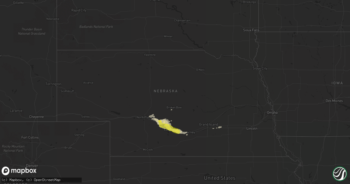
Hail Map in Nebraska on April 26, 2019
Get this storm
April 26 map
$229
one time, instant access
Download today. No call, no setup
Keep the $229
Bought the map and want the full workflow? Apply the entire $229 to a subscription within 7 days. None of it is wasted.
Every map, not just this one
This buys you this map. Subscription and you get every map we run, in the markets you choose from a few cities to whole states to nationwide. Plus real-time alerts the moment a storm fires.
Contact data
Name, contact info, occupancy, even credit band for addresses in the footprint. You go from where it hit to who to call.
Become the source they trust
Unlimited branding weather history reports on demand. You already have the documented answer ready for the property owner, and you are the one who showed up with it.
Property data and RoofTrace estimates
Pull up any address you have got, its value and the exact code rules for that jurisdiction, straight from One Click Code. Then RoofTrace estimates the squares, pitch, and roof value, priced the way you price.
Storm reports in Nebraska
Nebraska
| Date | Description |
|---|---|
| 04/26/20194:48 PM CDT | Video and report received from storm spotter dan fitts. |
| 04/26/20194:48 PM CDT | Relayed from kneb |
| 04/26/20194:46 PM CDT | Relayed from kneb |
| 04/26/20194:42 PM CDT | Severe thunderstorm winds measured at kneb radio broadcast studios in scottsbluff. |
| 04/26/20194:27 PM CDT | Lots of dust reducing visibility being lifted ahead of the thunderstorm and large limbs being broken out of trees. |
| 04/26/20194:25 PM CDT | Video and report received from storm spotter dan fitts. |
| 04/26/20194:21 PM CDT | Tree uprooted by thunderstorm winds south of gering on sandberg road. |
| 04/26/20194:53 AM CDT | At 952 PM CDT, a severe thunderstorm was located near Lexington, moving southeast at 30 mph. HAZARD...Quarter size hail. SOURCE...Radar indicated. IMPACT...Damage to vehicles is expected. This severe thunderstorm will be near... Elm Creek around 1020 PM CDT. Odessa around 1030 PM CDT. Funk around 1045 PM CDT.This includes Interstate 80 between mile markers 255 and 268. |
| 04/26/20194:24 AM CDT | At 924 PM CDT, severe thunderstorms were located along a line extending from 7 miles south of Oconto to near Cozad, moving southeast at 30 mph. HAZARD...60 mph wind gusts and quarter size hail. SOURCE...Radar indicated. IMPACT...Hail damage to vehicles is expected. Expect wind damage to roofs, siding, and trees. Severe thunderstorms will be near... Eddyville around 945 PM CDT. Lexington around 950 PM CDT. Sumner around 955 PM CDT. Overton around 1010 PM CDT.This includes Interstate 80 between mile markers 225 and 254. |
| 04/26/20193:58 AM CDT | At 858 PM MDT/958 PM CDT/, severe thunderstorms were located along a line extending from 7 miles northwest of Haigler to 9 miles south of Bonny Reservoir, moving east at 50 mph. HAZARD...70 mph wind gusts. SOURCE...Public. IMPACT...Expect considerable tree damage. Damage is likely to mobile homes, roofs, and outbuildings. Locations impacted include... Goodland, St. Francis, Benkelman, Kanorado, Ruleton, Bonny Reservoir and Bird City.This includes the following highways... Interstate 70 in Kansas between mile markers 0 and 35. Interstate 70 in Colorado between mile markers 444 and 450. |
| 04/26/20193:47 AM CDT | At 847 PM CDT, a severe thunderstorm was located near Brady, or 26 miles east of North Platte, moving east at 40 mph. HAZARD...60 mph wind gusts and quarter size hail. SOURCE...Radar indicated. IMPACT...Hail damage to vehicles is expected. Expect wind damage to roofs, siding, and trees. This severe thunderstorm will be near... Gothenburg around 900 PM CDT. Cozad and Willow Island around 910 PM CDT. Lexington around 930 PM CDT.This includes Interstate 80 between mile markers 209 and 240. |
| 04/26/20193:02 AM CDT | At 802 PM CDT, a severe thunderstorm was located near North Platte Airport, or 7 miles east of North Platte, moving east at 45 mph. HAZARD...60 mph wind gusts. SOURCE...Radar indicated. IMPACT...Expect damage to roofs, siding, and trees. Locations impacted include... North Platte, Brady, Maxwell, North Platte Airport, Keith, Etna and Vroman.This includes the following highways... Interstate 80 in Nebraska between mile markers 179 and 207. Highway 83 between mile markers 91 and 92. |
| 04/25/201910:33 PM CDT | At 332 PM MDT, a severe thunderstorm was located over Mitchell, or 10 miles northwest of Scottsbluff, moving east at 45 mph. HAZARD...70 mph wind gusts and penny size hail. SOURCE...Radar indicated. IMPACT...Expect considerable tree damage. Damage is likely to mobile homes, roofs, and outbuildings. Locations impacted include... Scottsbluff, Gering, Mitchell, Bayard, Terrytown, Morrill, Minatare, Lake Minatare Campground, Stegall, Scotts Bluff National Monument, Hubbard Hill, Moomaws Corner, Scottsbluff Airport, Lake Minatare, Lake Alice, Melbeta and McGrew. |
| 04/25/201910:24 PM CDT | Report from facebook. |
| 04/25/20199:54 PM CDT | At 253 PM MDT, a severe thunderstorm was located 11 miles northwest of Veteran, or 19 miles west of Torrington, moving east at 55 mph. HAZARD...60 mph wind gusts and penny size hail. SOURCE...Radar indicated. IMPACT...Expect damage to roofs, siding, and trees. Locations impacted include... Torrington, Morrill, Lyman, Yoder, Huntley, Stegall, Veteran and Henry. |
| 04/25/20199:09 PM CDT | Report relayed from dawson county dispatcher. |
All States Impacted by Hail Map on April 26, 2019
Cities Impacted by Hail Map on April 26, 2019
- Suffolk, VA
- Newport News, VA
- Carrollton, VA
- Maxwell, NE
- Corinne, UT
- Lexington, NE
- Brady, NE
- Overton, NE
- Elm Creek, NE
- Cozad, NE
- Gothenburg, NE
- Preston, ID
- Stafford Springs, CT
- Monson, MA
- Brimfield, MA
- New Braintree, MA
- Gilbertville, MA
- Barre, MA
- North Brookfield, MA
- Wales, MA
- South Barre, MA
- West Brookfield, MA
- Warren, MA
- Oakham, MA
- Grouse Creek, UT
- Cofield, NC
- Harrellsville, NC
- Gatesville, NC
- Hobbsville, NC
- Corapeake, NC
- Sunbury, NC
- Gates, NC
- Palmer, MA
- Wilbraham, MA
- Hampden, MA
- Callaway, NE
- Snowville, UT
- Chesapeake, VA
- Nephi, UT
- Portage, UT
- Axtell, NE
- Kearney, NE
- Conchas Dam, NM
- Trementina, NM
- Ahoskie, NC
- Aulander, NC
- Aurora, NE
- Hampton, NE
- Brigham City, UT
- Tribune, KS
- Wagon Mound, NM
- Delta, UT
- Holly, CO
- Roxobel, NC
- Winton, NC
- Woodland, NC
- Kelford, NC
- Cornish, UT
- Lewiston, UT
- Virginia Beach, VA
- Odessa, NE
- Cedar Valley, UT
- Lancaster, VA
- Dugway, UT
- Raton, NM
- Millville, NJ
- Vineland, NJ
- Capitan, NM
- Franklin, ID
- Millersville, MD
- Severn, MD
- Gambrills, MD
- Odenton, MD
- Broken Bow, NE
- Mona, UT
- Lakin, KS
- Deerfield, KS
- Yeso, NM
- Vaughn, NM
- Windsor, NC
- Roswell, NM
- Malad City, ID
- Center Cross, VA
- Giltner, NE
- Mantua, UT
- Fillmore, UT
- Willow Island, NE
- Fort Monroe, VA
- Norfolk, VA
- Willington, CT
- Tolland, CT
- Corona, NM
- Tooele, UT
- Goshen, UT
- Hertford, NC
- Eddyville, NE
- Holland, MA
- West Warren, MA
- Paradise, UT
- Henderson, NE
- Baggs, WY
- Dixon, WY
- Hampton, VA
- Solano, NM
- Coventry, CT
- Ripley, WV
- Given, WV
- Kenna, WV
- Evans, WV


