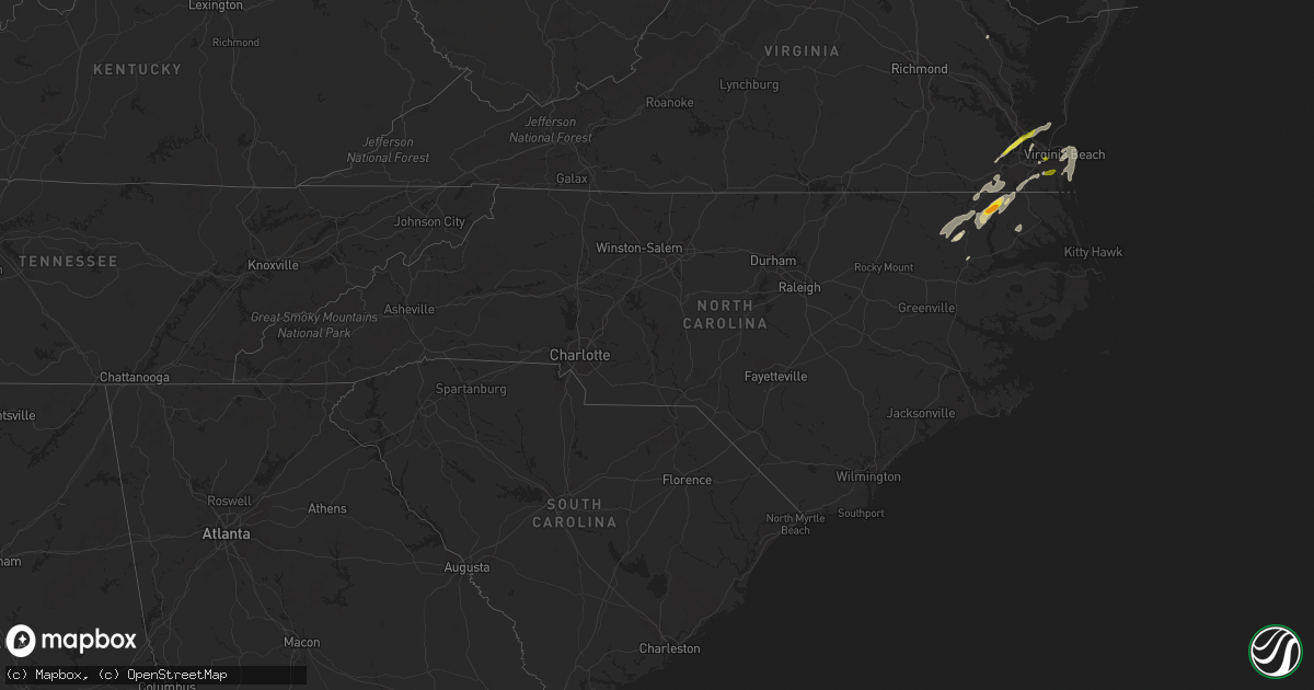
Hail Map in North Carolina on April 26, 2019
Get this storm
April 26 map
$229
one time, instant access
Download today. No call, no setup
Keep the $229
Bought the map and want the full workflow? Apply the entire $229 to a subscription within 7 days. None of it is wasted.
Every map, not just this one
This buys you this map. Subscription and you get every map we run, in the markets you choose from a few cities to whole states to nationwide. Plus real-time alerts the moment a storm fires.
Contact data
Name, contact info, occupancy, even credit band for addresses in the footprint. You go from where it hit to who to call.
Become the source they trust
Unlimited branding weather history reports on demand. You already have the documented answer ready for the property owner, and you are the one who showed up with it.
Property data and RoofTrace estimates
Pull up any address you have got, its value and the exact code rules for that jurisdiction, straight from One Click Code. Then RoofTrace estimates the squares, pitch, and roof value, priced the way you price.
Storm reports in North Carolina
North Carolina
| Date | Description |
|---|---|
| 04/26/20194:41 PM CDT | Trees down along highway 210 in far nw bladen county near the cumberland county border |
| 04/26/20193:47 PM CDT | Edgecombe county 911 received report of 1 tree down across roadway at nc 122 s near lily pad lane in pinetops. |
| 04/26/20193:30 PM CDT | Strong winds lifted up a carport and dropped it down onto a motorcycle and car. |
| 04/26/20193:26 PM CDT | 40 ft tree branch in the road at 1522 branch st. Time estimated from radar. |
| 04/26/20193:02 PM CDT | Johnston county 911 received report of tree down across roadway at 3030 hwy 42e near neuse colony subdivision in clayton. |
| 04/26/20192:53 PM CDT | Johnston county 911 received report of tree down at smith rd and water oak dr west of smithfield. |
| 04/26/20192:20 PM CDT | Tree downed along sam newell rd. |
| 04/26/20192:00 PM CDT | Tree and utility lines downed along tate st |
| 04/26/20191:25 PM CDT | Tree downed across south dekalb st. |
| 04/26/201911:15 AM CDT | Time estimated from radar. |
| 04/26/201911:00 AM CDT | Trees down on water plant rd. In gates... Nc. Time estimated from radar. |
| 04/26/201910:50 AM CDT | Trees down. Reported at cofield... Nc. Time estimated from radar. |
| 04/26/201910:45 AM CDT | Trees down. Reported at tunish rd winton... Nc. Time estimated from radar. |
| 04/26/201910:41 AM CDT | Tree down in bowles place dr. Time estimated from radar. |
| 04/26/201910:41 AM CDT | Piney island reports wind gust to 53 knots. |
| 04/26/201910:35 AM CDT | Several trees down in the beechwood country club area. Time estimated from radar. |
| 04/26/201910:33 AM CDT | Numerous trees down on the golf course north of ahoski. Minor damage to some outbuildings. |
| 04/26/201910:30 AM CDT | Tree blocking lane of traffic on vaughans creek rd. Time estimated from radar. |
| 04/26/201910:25 AM CDT | Estimated 60 mph wind gust with pea size hail. |
| 04/26/20197:53 AM CDT | At 1252 PM EDT, severe thunderstorms were located along a line extending from near Colerain to 6 miles southwest of Valhalla to 7 miles southeast of Windsor, moving northeast at 40 mph. HAZARD...60 mph wind gusts and quarter size hail. SOURCE...Radar indicated. IMPACT...Minor damage to vehicles is possible. Expect wind damage to trees and powerlines. Severe thunderstorms will be near, Ryland, Colerain and Tyner around 100 PM EDT. Valhalla and Rockyhock around 105 PM EDT. Winfall, Belvidere and Cape Colony around 120 PM EDT. Chapanoke around 130 PM EDT. Snug Harbor around 135 PM EDT. Elizabeth City, Hertford and Burgess around 140 PM EDT. Camden, Elizabeth City State University and Nixonton around 145 PM EDT.Other locations impacted by these severe thunderstorms include GoosePond, Bob White Fork, Holiday Island, Arrowhead Beach, Saint Johns,Parkville, Mount Gould, Hancock, Yeopim Station and Pasquotank. |
| 04/26/20196:18 AM CDT | At 1117 AM EDT, severe thunderstorms were located along a line extending from 6 miles northwest of Conway to near Woodland to near Lewiston Woodville, moving northeast at 40 mph. HAZARD...60 mph wind gusts and quarter size hail. SOURCE...Radar indicated. IMPACT...Minor damage to vehicles is possible. Expect wind damage to trees and powerlines. Severe thunderstorms will be near, Boykins and Chowan University around 1130 AM EDT. Murfreesboro around 1135 AM EDT. Newsoms around 1140 AM EDT. Powellsville and Como around 1145 AM EDT. Ahoskie and Courtland around 1150 AM EDT. Franklin around 1155 AM EDT. Winton, Cofield, Harrellsville and Hunterdale around 1200 PM EDT.Other locations impacted by these severe thunderstorms includeEagletown, Milwaukee, Tunis, Kelford, Earleys, Menola, Chowan Beach,Topsy, Mapleton and Dort. |
| 04/26/201912:16 AM CDT | At 515 PM EDT, a severe thunderstorm was located over Tolarsville, or 13 miles northeast of Lumberton, moving east at 45 mph. HAZARD...60 mph wind gusts and quarter size hail. SOURCE...Radar indicated. IMPACT...Minor hail damage to vehicles is possible. Expect wind damage to trees and power lines. Locations impacted include... Tobermory, Howellsville, Ruskin, Tolarsville, Duart, Ammon, White Oak, Jerome, White Lake, Dublin and Tar Heel. |
| 04/25/201911:17 PM CDT | At 416 PM EDT, a severe thunderstorm was located near Bailey, or 16 miles northeast of Smithfield, moving northeast at 50 mph. HAZARD...60 mph wind gusts and penny size hail. SOURCE...Radar indicated. IMPACT...Expect damage to roofs, siding, and trees. Locations impacted include... Rocky Mount, Tarboro, Wilson, Elm City, Dortches, Bailey, Princeville, Sharpsburg, Pinetops and Middlesex. |
All States Impacted by Hail Map on April 26, 2019
Cities Impacted by Hail Map on April 26, 2019
- Suffolk, VA
- Newport News, VA
- Carrollton, VA
- Maxwell, NE
- Corinne, UT
- Lexington, NE
- Brady, NE
- Overton, NE
- Elm Creek, NE
- Cozad, NE
- Gothenburg, NE
- Preston, ID
- Stafford Springs, CT
- Monson, MA
- Brimfield, MA
- New Braintree, MA
- Gilbertville, MA
- Barre, MA
- North Brookfield, MA
- Wales, MA
- South Barre, MA
- West Brookfield, MA
- Warren, MA
- Oakham, MA
- Grouse Creek, UT
- Cofield, NC
- Harrellsville, NC
- Gatesville, NC
- Hobbsville, NC
- Corapeake, NC
- Sunbury, NC
- Gates, NC
- Palmer, MA
- Wilbraham, MA
- Hampden, MA
- Callaway, NE
- Snowville, UT
- Chesapeake, VA
- Nephi, UT
- Portage, UT
- Axtell, NE
- Kearney, NE
- Conchas Dam, NM
- Trementina, NM
- Ahoskie, NC
- Aulander, NC
- Aurora, NE
- Hampton, NE
- Brigham City, UT
- Tribune, KS
- Wagon Mound, NM
- Delta, UT
- Holly, CO
- Roxobel, NC
- Winton, NC
- Woodland, NC
- Kelford, NC
- Cornish, UT
- Lewiston, UT
- Virginia Beach, VA
- Odessa, NE
- Cedar Valley, UT
- Lancaster, VA
- Dugway, UT
- Raton, NM
- Millville, NJ
- Vineland, NJ
- Capitan, NM
- Franklin, ID
- Millersville, MD
- Severn, MD
- Gambrills, MD
- Odenton, MD
- Broken Bow, NE
- Mona, UT
- Lakin, KS
- Deerfield, KS
- Yeso, NM
- Vaughn, NM
- Windsor, NC
- Roswell, NM
- Malad City, ID
- Center Cross, VA
- Giltner, NE
- Mantua, UT
- Fillmore, UT
- Willow Island, NE
- Fort Monroe, VA
- Norfolk, VA
- Willington, CT
- Tolland, CT
- Corona, NM
- Tooele, UT
- Goshen, UT
- Hertford, NC
- Eddyville, NE
- Holland, MA
- West Warren, MA
- Paradise, UT
- Henderson, NE
- Baggs, WY
- Dixon, WY
- Hampton, VA
- Solano, NM
- Coventry, CT
- Ripley, WV
- Given, WV
- Kenna, WV
- Evans, WV


