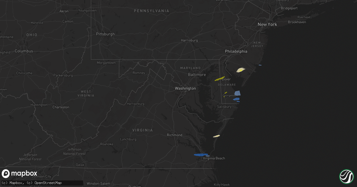
Hail Map in Delaware on April 21, 2021
Get this storm
April 21 map
$229
one time, instant access
Download today. No call, no setup
Keep the $229
Bought the map and want the full workflow? Apply the entire $229 to a subscription within 7 days. None of it is wasted.
Every map, not just this one
This buys you this map. Subscription and you get every map we run, in the markets you choose from a few cities to whole states to nationwide. Plus real-time alerts the moment a storm fires.
Contact data
Name, contact info, occupancy, even credit band for addresses in the footprint. You go from where it hit to who to call.
Become the source they trust
Unlimited branding weather history reports on demand. You already have the documented answer ready for the property owner, and you are the one who showed up with it.
Property data and RoofTrace estimates
Pull up any address you have got, its value and the exact code rules for that jurisdiction, straight from One Click Code. Then RoofTrace estimates the squares, pitch, and roof value, priced the way you price.
Storm reports in Delaware
Delaware
| Date | Description |
|---|---|
| 04/21/20211:59 PM CDT | Personal weather station kdeselby13. |
| 04/21/20211:35 PM CDT | A local report indicates 58 MPH wind near 1 WNW LEWES |
| 04/21/20211:14 PM CDT | A local report indicates 1.00 inch wind near SEAFORD |
| 04/21/20211:14 PM CDT | A local report indicates 1.00 inch wind near BRIDGEVILLE |
| 04/21/20211:12 PM CDT | Time estimated from radar. |
| 04/21/20211:12 PM CDT | Time estimated from radar. |
| 04/20/20218:23 PM CDT | At 122 PM EDT, severe thunderstorms were located along a line extending from near Hartly to Queen Anne, moving east at 55 mph. HAZARD...60 mph wind gusts and quarter size hail. SOURCE...Trained weather spotters. Quarter size hail was reported near Sudlersville. IMPACT...Minor damage to vehicles is possible. Wind damage to roofs, siding, trees, and power lines is possible. Locations impacted include... Dover, Milford, Denton, Harrington, Camden, Greensboro, Oakland, Ridgely, Cheswold, Sudlersville, Bowers, Goldsboro, Queen Anne, Woodside, Viola, Hartly, Rising Sun-Lebanon, Starr, Jumptown and Hazlettville. |
| 04/20/20218:10 PM CDT | At 109 PM EDT, severe thunderstorms were located along a line extending from near Cheyney to near Stanton, moving northeast at 60 mph. HAZARD...60 mph wind gusts and quarter size hail. SOURCE...Radar indicated. IMPACT...Minor damage to vehicles is possible. Wind damage to roofs, siding, trees, and power lines is possible. Locations impacted include... Philadelphia, Trenton, Camden, Wilmington, Newark, West Chester, Gloucester City, Cherry Hill, Bensalem, Evesham, Mount Laurel, Ewing, Chester, Willingboro, Deptford, West Deptford, Princeton, Florence, Bellmawr and Yeadon.People at the Esperanza Community Vaccination Site, Burlington CountyMega Site, and Pennsylvania Convention Center Vaccination Site shouldseek safe shelter immediately!This includes the following highways... New Jersey Turnpike between exits 3 and 6A. Pennsylvania Turnpike between mile markers 333 and 359. Interstate 95 in Pennsylvania between mile markers 0 and 40. Interstate 95 in Delaware between mile markers 2 and 23. Interstate 76 in Pennsylvania between mile markers 329 and 351. Interstate 76 in New Jersey between mile markers 0 and 3. Interstate 295 in New Jersey between mile markers 7 and 50, andbetween mile markers 68 and 76. Interstate 676 in Pennsylvania between mile markers 0 and 1. Interstate 676 in New Jersey between mile markers 0 and 4. Interstate 476 in Pennsylvania between mile markers 0 and 19. |
All States Impacted by Hail Map on April 21, 2021
Cities Impacted by Hail Map on April 21, 2021
- Millville, NJ
- Vineland, NJ
- Barkhamsted, CT
- Franktown, VA
- Exmore, VA
- Painter, VA
- Milmay, NJ
- Richland, NJ
- Mays Landing, NJ
- Savoy, MA
- Cummington, MA
- Plainfield, MA
- West Granby, CT
- East Hartland, CT
- Smithfield, VA
- Norfolk, VA
- Newport News, VA
- Suffolk, VA
- Windsor, VA
- Carrollton, VA
- Virginia Beach, VA
- Ingleside, MD
- Church Hill, MD
- Cheswold, DE
- Dover, DE
- Barclay, MD
- Hartly, DE
- Clayton, DE
- Sudlersville, MD
- Marydel, MD
- Greenwood, DE
- Ellendale, DE
- Bridgeville, DE
- Seaford, DE
- Goshen, CT
- Litchfield, CT
- Cornwall Bridge, CT
- Torrington, CT
- Lewes, DE
- Rehoboth Beach, DE
- Beach Haven, NJ
- Dagsboro, DE
- Millsboro, DE
- Bethany Beach, DE
- Ocean View, DE
- Frankford, DE
- Anderson, IN
- Canton, CT
- Pine Meadow, CT
- West Simsbury, CT
- Hampden, MA
- Thorndike, MA
- East Longmeadow, MA
- Feeding Hills, MA
- Suffield, CT
- Three Rivers, MA
- Granby, CT
- West Warren, MA
- Springfield, MA
- Monson, MA
- West Cornwall, CT
- Fiskdale, MA
- Agawam, MA
- Simsbury, CT
- West Springfield, MA
- Palmer, MA
- New Hartford, CT
- Wilbraham, MA
- Bondsville, MA
- Somers, CT
- West Brookfield, MA
- Enfield, CT
- Brimfield, MA
- West Suffield, CT
- Southwick, MA
- Ludlow, MA
- Warren, MA
- Indian Orchard, MA
- Longmeadow, MA
- Sharon, CT
- North Granby, CT
- East Granby, CT
- Belchertown, MA
- Brookfield, MA
- Kent, CT
- South Kent, CT
- New Preston Marble Dale, CT


