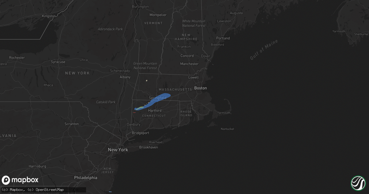
Hail Map in Connecticut on April 21, 2021
Get this storm
April 21 map
$229
one time, instant access
Download today. No call, no setup
Keep the $229
Bought the map and want the full workflow? Apply the entire $229 to a subscription within 7 days. None of it is wasted.
Every map, not just this one
This buys you this map. Subscription and you get every map we run, in the markets you choose from a few cities to whole states to nationwide. Plus real-time alerts the moment a storm fires.
Contact data
Name, contact info, occupancy, even credit band for addresses in the footprint. You go from where it hit to who to call.
Become the source they trust
Unlimited branding weather history reports on demand. You already have the documented answer ready for the property owner, and you are the one who showed up with it.
Property data and RoofTrace estimates
Pull up any address you have got, its value and the exact code rules for that jurisdiction, straight from One Click Code. Then RoofTrace estimates the squares, pitch, and roof value, priced the way you price.
Storm reports in Connecticut
Connecticut
| Date | Description |
|---|---|
| 04/21/20213:05 PM CDT | Tree down on wires on george washington rd. |
| 04/21/20213:03 PM CDT | Report from mping: 3-inch tree limbs broken; power poles broken. |
| 04/21/20212:50 PM CDT | Tree down blocking notch road. |
| 04/21/20212:45 PM CDT | Tree down on house on butterturn rd. |
| 04/21/20212:25 PM CDT | Wires down from wind. Power is out. |
| 04/21/20212:20 PM CDT | Wires down from wind. |
| 04/21/20212:17 PM CDT | Tree down on wires at intersection of warren turnpike and water st. |
| 04/21/20212:15 PM CDT | Tree down on wires on route 7 north to page rd. |
| 04/21/20212:13 PM CDT | Tree limbs down... Power out. |
| 04/21/20212:00 PM CDT | Trees were snapped and downed across route 7 near kent falls state park |
| 04/21/20211:50 PM CDT | Wires down... Trees down... Car port flipped over at bulls bridge body shop. |
| 04/21/20211:49 PM CDT | Nws survey team confirmed an ef-0 tornado near bulls bridge... Ct. Max winds of 85 mph. |
| 04/21/20211:48 PM CDT | Small trees down near kent falls state park entrance along route 7n. |
| 04/21/20211:47 PM CDT | Tree down on wires on kent road |
| 04/20/20219:53 PM CDT | At 253 PM EDT, severe thunderstorms were located along a line extending from Gaylordsville to Port Washington, moving east at 40 mph. HAZARD...60 mph wind gusts and penny size hail. SOURCE...Radar indicated. IMPACT...Expect damage to trees and power lines. Locations impacted include... Bridgeport, New Haven, Stamford, Waterbury, Norwalk, Danbury, Meriden, White Plains, Milford, Middletown, Wallingford, Shelton, Naugatuck, Port Chester and Guilford. |
| 04/20/20219:10 PM CDT | At 209 PM EDT, a severe thunderstorm was located over Cold Spring, moving east at 45 mph. HAZARD...60 mph wind gusts. SOURCE...Radar indicated. IMPACT...Expect damage to trees and power lines. This severe thunderstorm will be near... Fahnestock State Park around 220 PM EDT. Lake Carmel and Carmel around 230 PM EDT. Brewster around 235 PM EDT. New Fairfield around 240 PM EDT. Danbury and Brookfield around 250 PM EDT. Newtown around 255 PM EDT. |
All States Impacted by Hail Map on April 21, 2021
Cities Impacted by Hail Map on April 21, 2021
- Millville, NJ
- Vineland, NJ
- Barkhamsted, CT
- Franktown, VA
- Exmore, VA
- Painter, VA
- Milmay, NJ
- Richland, NJ
- Mays Landing, NJ
- Savoy, MA
- Cummington, MA
- Plainfield, MA
- West Granby, CT
- East Hartland, CT
- Smithfield, VA
- Norfolk, VA
- Newport News, VA
- Suffolk, VA
- Windsor, VA
- Carrollton, VA
- Virginia Beach, VA
- Ingleside, MD
- Church Hill, MD
- Cheswold, DE
- Dover, DE
- Barclay, MD
- Hartly, DE
- Clayton, DE
- Sudlersville, MD
- Marydel, MD
- Greenwood, DE
- Ellendale, DE
- Bridgeville, DE
- Seaford, DE
- Goshen, CT
- Litchfield, CT
- Cornwall Bridge, CT
- Torrington, CT
- Lewes, DE
- Rehoboth Beach, DE
- Beach Haven, NJ
- Dagsboro, DE
- Millsboro, DE
- Bethany Beach, DE
- Ocean View, DE
- Frankford, DE
- Anderson, IN
- Canton, CT
- Pine Meadow, CT
- West Simsbury, CT
- Hampden, MA
- Thorndike, MA
- East Longmeadow, MA
- Feeding Hills, MA
- Suffield, CT
- Three Rivers, MA
- Granby, CT
- West Warren, MA
- Springfield, MA
- Monson, MA
- West Cornwall, CT
- Fiskdale, MA
- Agawam, MA
- Simsbury, CT
- West Springfield, MA
- Palmer, MA
- New Hartford, CT
- Wilbraham, MA
- Bondsville, MA
- Somers, CT
- West Brookfield, MA
- Enfield, CT
- Brimfield, MA
- West Suffield, CT
- Southwick, MA
- Ludlow, MA
- Warren, MA
- Indian Orchard, MA
- Longmeadow, MA
- Sharon, CT
- North Granby, CT
- East Granby, CT
- Belchertown, MA
- Brookfield, MA
- Kent, CT
- South Kent, CT
- New Preston Marble Dale, CT


