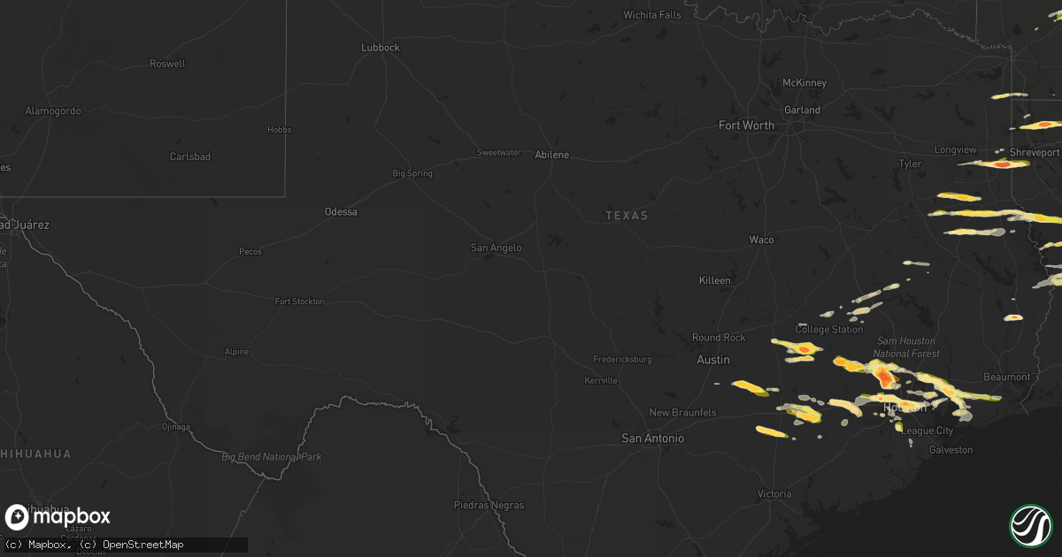
Hail Map in Texas on April 19, 2015
Get this storm
April 19 map
$229
one time, instant access
Download today. No call, no setup
Keep the $229
Bought the map and want the full workflow? Apply the entire $229 to a subscription within 7 days. None of it is wasted.
Every map, not just this one
This buys you this map. Subscription and you get every map we run, in the markets you choose from a few cities to whole states to nationwide. Plus real-time alerts the moment a storm fires.
Contact data
Name, contact info, occupancy, even credit band for addresses in the footprint. You go from where it hit to who to call.
Become the source they trust
Unlimited branding weather history reports on demand. You already have the documented answer ready for the property owner, and you are the one who showed up with it.
Property data and RoofTrace estimates
Pull up any address you have got, its value and the exact code rules for that jurisdiction, straight from One Click Code. Then RoofTrace estimates the squares, pitch, and roof value, priced the way you price.
Storm reports in Texas
Texas
| Date | Description |
|---|---|
| 04/19/20156:50 PM CDT | 1.5 ping pong size hail north of sealy reported by wfo midland employee. |
| 04/19/20156:39 PM CDT | 1.75 inch hail hwy 249 and louetta rd |
| 04/19/20156:39 PM CDT | 1.75 inch hail hwy 249 and louetta rd |
| 04/19/20156:36 PM CDT | Twitter report of baseball size hail at hwy 249 and boudreaux road south of tomball. |
| 04/19/20156:35 PM CDT | Quarter size hail in the james community. |
| 04/19/20156:25 PM CDT | Quarter size hail in the martinsville community. |
| 04/19/20156:22 PM CDT | A local report indicates 1.25 inch wind near NACOGDOCHES |
| 04/19/20156:10 PM CDT | A local report indicates 2.00 inch wind near WALLER |
| 04/19/20156:04 PM CDT | A local report indicates 1.75 inch wind near HEMPSTEAD |
| 04/19/20156:03 PM CDT | A local report indicates 2.00 inch wind near TOMBALL |
| 04/19/20156:00 PM CDT | Hail ranged from golf ball to baseball sized in the town of de berry |
| 04/19/20155:58 PM CDT | A local report indicates 1.00 inch wind near HEMPSTEAD |
| 04/19/20155:57 PM CDT | A local report indicates 1.75 inch wind near 3 NE NACOGDOCHES |
| 04/19/20155:55 PM CDT | A local report indicates 1.00 inch wind near GARY CITY |
| 04/19/20155:50 PM CDT | Public reports ping pong size hail near dotson community. |
| 04/19/20155:50 PM CDT | Twitter report of quarter size hail. |
| 04/19/20155:45 PM CDT | A local report indicates 1.00 inch wind near 1 NNW NACOGDOCHES |
| 04/19/20155:45 PM CDT | A local report indicates 1.75 inch wind near GARRISON |
| 04/19/20155:40 PM CDT | Quarter size hail in new hope community. |
| 04/19/20155:40 PM CDT | Ping pong size hail in smyrna communtity |
| 04/19/20155:40 PM CDT | Public reports ping pong size hail in dotson community. |
| 04/19/20155:35 PM CDT | Sheriff reports hail at intersection of hwy 59 and fm road 1186. |
| 04/19/20155:31 PM CDT | A local report indicates 1.00 inch wind near 2 N LA GRANGE |
| 04/19/20155:30 PM CDT | A local report indicates 1.00 inch wind near 7 S MOUNT ENTERPRISE |
| 04/19/20155:30 PM CDT | Golf ball hail covering the ground |
| 04/19/20155:27 PM CDT | 1.00 hail on fm 1488 |
| 04/19/20155:20 PM CDT | Golfball size hail in minden community. |
| 04/19/20155:00 PM CDT | Baseball to softball size hail reported by college student driving on highway 6. |
| 04/19/20154:58 PM CDT | A local report indicates 1.50 inch wind near 10 SW HENDERSON |
| 04/19/20154:24 PM CDT | A local report indicates 1.75 inch wind near 4 SW SMITHVILLE |
| 04/19/20154:12 PM CDT | A local report indicates 1.00 inch wind near 1 NE TOGO |
| 04/19/20154:09 PM CDT | A local report indicates 1.75 inch wind near 3 SW UPTON |
| 04/19/20154:02 PM CDT | Reported near kurten |
| 04/19/20154:00 PM CDT | A local report indicates 1.75 inch wind near 2 ENE WATTERSON |
| 04/19/20153:58 PM CDT | Cr 431 |
| 04/19/20153:50 PM CDT | A local report indicates 1.75 inch wind near 2 NNE ROCKNE |
| 04/19/20153:50 PM CDT | Public report of 1 inch size hail near lake somerville. |
| 04/19/20153:48 PM CDT | Reported in lyons |
| 04/19/20153:24 PM CDT | Near deanville |
| 04/18/20158:48 PM CDT | 1 hail vcnty of hwy 518 hwy 288 and kirby |
| 04/18/20158:30 PM CDT | A local report indicates 1.75 inch wind near 1 N HALLETTSVILLE |
| 04/18/20158:25 PM CDT | Public reported estimated one inch hail |
| 04/18/20158:16 PM CDT | A local report indicates 1.00 inch wind near 5 ENE COVE |
| 04/18/20157:50 PM CDT | Quarter size hail in columbus. |
| 04/18/20157:50 PM CDT | Quarter size hail in weimer. |
| 04/18/20157:48 PM CDT | A local report indicates 1.00 inch wind near 5 ENE COVE |
| 04/18/20157:47 PM CDT | Quarter size hail houston heights |
| 04/18/20157:43 PM CDT | A local report indicates 1.75 inch wind near 8 S COLUMBUS |
| 04/18/20157:40 PM CDT | Public reported hail between quarter and golf ball size |
| 04/18/20157:38 PM CDT | Quarter size hail reported in city of weston lakes. |
| 04/18/20157:30 PM CDT | Golf ball size hail 6 miles ne of mont belvieu. |
| 04/18/20157:30 PM CDT | Public measured two inch hail and also observed golf ball sized hail. |
| 04/18/20157:29 PM CDT | Golf ball size hail at west little york and north eldridge. |
| 04/18/20157:25 PM CDT | A local report indicates 1.25 inch wind near 2 S HUXLEY |
| 04/18/20157:25 PM CDT | A local report indicates 1.25 inch wind near 5 SSW HUXLEY |
| 04/18/20157:11 PM CDT | A local report indicates 1.00 inch wind near 4 WNW JERSEY VILLAGE |
| 04/18/20157:05 PM CDT | Reported at cypresswood and hwy 249 |
All States Impacted by Hail Map on April 19, 2015
Cities Impacted by Hail Map on April 19, 2015
- Burnsville, MS
- Hot Springs National Park, AR
- Pearcy, AR
- Malvern, AR
- Rayville, LA
- Pioneer, LA
- Oak Grove, LA
- Oak Ridge, LA
- Mer Rouge, LA
- Collinston, LA
- Converse, LA
- Piggott, AR
- Saint Francis, AR
- Campbell, MO
- Chappell Hill, TX
- Brenham, TX
- Washington, TX
- Heth, AR
- Cave City, AR
- Foley, AL
- Marianna, AR
- Oakland, MS
- Batesville, MS
- Enid, MS
- Courtland, MS
- Pope, MS
- Bastrop, TX
- Knobel, AR
- Pollard, AR
- Clarkton, MO
- Malden, MO
- Parma, MO
- Corning, AR
- Rector, AR
- Gideon, MO
- Weimar, TX
- Columbus, TX
- Murfreesboro, AR
- Amity, AR
- Houston, TX
- Sugar Land, TX
- Dayton, TX
- Nacogdoches, TX
- Alvin, TX
- Liverpool, TX
- Schulenburg, TX
- Brookshire, TX
- Wallis, TX
- Cat Spring, TX
- Sealy, TX
- Fulshear, TX
- Shreveport, LA
- De Berry, TX
- Marshall, TX
- Bethany, LA
- Waskom, TX
- Keithville, LA
- Ozark, AL
- La Grange, TX
- Alleyton, TX
- Garwood, TX
- Glidden, TX
- Palestine, AR
- Colt, AR
- Lexington, TX
- Crockett, TX
- Spring, TX
- Conroe, TX
- Hallettsville, TX
- Sublime, TX
- Little Rock, AR
- Wallisville, TX
- Anahuac, TX
- Wilson, AR
- Marked Tree, AR
- Dyess, AR
- Osceola, AR
- Keiser, AR
- Henning, TN
- Lepanto, AR
- Pittsburg, OK
- Kiowa, OK
- Benton, LA
- North Zulch, TX
- Iola, TX
- Timpson, TX
- Garrison, TX
- Shelbyville, TX
- Belmont, LA
- Pleasant Hill, LA
- Marthaville, LA
- Cushing, TX
- Center, TX
- Zwolle, LA
- Tenaha, TX
- Robeline, LA
- Neelyville, MO
- White Hall, AR
- Pine Bluff, AR
- Colfax, LA
- Lena, LA
- Havana, AR
- Blue Mountain, AR
- New Blaine, AR
- Magazine, AR
- Booneville, AR
- Delaware, AR
- Dardanelle, AR
- Paris, AR
- Lake Providence, LA
- Thaxton, MS
- Mabelvale, AR
- Vidalia, LA
- Woodville, MS
- Center Point, LA
- Deville, LA
- Jonesville, LA
- Effie, LA
- Marksville, LA
- Monterey, LA
- Crosby, MS
- Acme, LA
- Clayton, GA
- Dry Prong, LA
- Boyce, LA
- Pineville, LA
- Ball, LA
- Pollock, LA
- Grayson, LA
- Doddridge, AR
- Glen Allan, MS
- Mayersville, MS
- Chatham, MS
- Greenville, MS
- Anguilla, MS
- Hollandale, MS
- Rolling Fork, MS
- Pond Creek, OK
- Hackett, AR
- Wister, OK
- Mansfield, AR
- Huntington, AR
- Greenwood, AR
- Poteau, OK
- Cameron, OK
- Midland, AR
- Hartford, AR
- Lafe, AR
- Kirbyville, TX
- Conway, AR
- Wooster, AR
- Greenbrier, AR
- Mangham, LA
- Heber Springs, AR
- Lambert, MS
- Cloutierville, LA
- Provencal, LA
- Ponte Vedra Beach, FL
- Plainview, AR
- Carthage, AR
- Gary, TX
- Katy, TX
- Smithville, TX
- Charleston, MS
- Moulton, TX
- Shiner, TX
- Greenwood, MS
- Carrollton, MS
- San Augustine, TX
- Benton, AR
- Glenwood, AR
- Oxford, MS
- Mount Enterprise, TX
- Long Branch, TX
- Paragould, AR
- Marmaduke, AR
- Clarksville, AR
- Sheridan, AR
- Leola, AR
- Grapevine, AR
- Cecil, AR
- Charleston, AR
- Ozark, AR
- Earle, AR
- Widener, AR
- Mount Ida, AR
- Etta, MS
- Monroe, LA
- Columbia, LA
- Sledge, MS
- Sardis, MS
- Crenshaw, MS
- Tomball, TX
- Pinehurst, TX
- Magnolia, TX
- Cypress, TX
- Jessieville, AR
- Waller, TX
- Navasota, TX
- Hempstead, TX
- Crosby, TX
- Hattieville, AR
- Danville, AR
- Pottsville, AR
- Atkins, AR
- Abbeville, MS
- Okolona, MS
- Aberdeen, MS
- Huntsville, TX
- Bedias, TX
- Laneville, TX
- Henderson, TX
- West Point, MS
- Columbus, MS
- Burton, TX
- Ledbetter, TX
- Wardville, OK
- Atlanta, TX
- Somerville, TX
- Caldwell, TX
- Bokoshe, OK
- Shady Point, OK
- Winona, MS
- Pocahontas, AR
- Black Rock, AR
- Weiner, AR
- Harrisburg, AR
- Fisher, AR
- Dundee, MS
- Helena, AR
- Marks, MS
- Friars Point, MS
- Coahoma, MS
- Clarksdale, MS
- Waldron, AR
- Myrtle, MS
- Hankamer, TX
- Pearland, TX
- Manvel, TX
- Fresno, TX
- Rosharon, TX
- Itta Bena, MS
- Moorhead, MS
- Sunflower, MS
- Indianola, MS
- Baytown, TX
- Prescott, AR
- Wabbaseka, AR
- Scottsboro, AL
- Woodville, AL
- Pangburn, AR
- Cleveland, AR
- Clinton, AR
- Tumbling Shoals, AR
- Mount Vernon, AR
- Center Ridge, AR
- Judsonia, AR
- Rose Bud, AR
- Romance, AR
- Searcy, AR
- Enola, AR
- Springfield, AR
- Pleasant Plains, AR
- Wilburn, AR
- Belleville, AR
- Floral, AR
- Guy, AR
- Solgohachia, AR
- Damascus, AR
- Quitman, AR
- Drasco, AR
- Bee Branch, AR
- Star City, AR
- Devers, TX
- Porter, TX
- Huffman, TX
- New Caney, TX
- Winnie, TX
- Liberty, TX
- Kingwood, TX
- Humble, TX
- Millington, TN
- Drummonds, TN
- Bryan, TX
- Highlands, TX
- Bivins, TX
- Bonnerdale, AR
- Caddo Gap, AR
- Potts Camp, MS
- Hickory Flat, MS
- Pontotoc, MS
- Gould, AR
- Yorktown, AR
- Ponca, AR
- Subiaco, AR
- Scranton, AR
- Langley, AR
- Channelview, TX
- Pasadena, TX
- Galena Park, TX
- Jennings, OK
- Maramec, OK
- Madisonville, TX
- New Llano, LA
- Anacoco, LA
- Fort Polk, LA
- Leesville, LA
- Hornbeck, LA
- Plumerville, AR
- Coalgate, OK
- Stevenson, AL
- Flat Rock, AL
- Hollywood, AL
- Grant, AL
- Pisgah, AL
- Greenway, AR
- Gibson, MO
- Peach Orchard, AR
- Catron, MO
- Lilbourn, MO
- Delaplaine, AR
- Houston, AR
- Perry, AR
- Morrilton, AR
- Perryville, AR
- Mayflower, AR
- Roland, AR
- Gurdon, AR
- Okolona, AR
- Stilwell, OK
- Bunch, OK
- Forrest City, AR
- Madison, AR
- Many, LA
- Lyons, TX
- Grady, AR
- Rison, AR
- Arkadelphia, AR
- Altheimer, AR
- Stuart, OK
- Yates Center, KS
- North Little Rock, AR
- Rusk, TX
- Philipp, MS
- Minter City, MS
- Wheatley, AR
- Brinkley, AR
- Moro, AR
- Belcher, LA
- Hockley, TX
- Montgomery, TX
- Waynesboro, TN
- Olivehill, TN
- Kelly, LA
- Olla, LA
- Minden, LA
- Cotton Valley, LA
- Haughton, LA
- Mooringsport, LA
- Deer, AR
- Pettigrew, AR
- Kingston, AR
- Bradford, AR
- London, AR
- Dover, AR
- Russellville, AR
- Knoxville, AR
- Lamar, AR
- Ola, AR
- Casa, AR
- McCarley, MS
- Bismarck, AR
- Schlater, MS
- Ruleville, MS
- Holcomb, MS
- Grenada, MS
- Rosanky, TX
- Red Rock, TX
- Cedar Creek, TX
- Montgomery, LA
- Memphis, TN
- Houston, MS
- Elaine, AR
- Washington, AR
- Arlington, TN
- Gonzales, TX
- Longton, KS
- Elk Falls, KS
- Tatum, TX
- Palm Coast, FL
- Saint Augustine, FL
- Crane Hill, AL
- Vian, OK
- Stigler, OK
- Holcomb, MO
- Maumelle, AR
- Spivey, KS
- Kingman, KS
- Midway, TX
- Carbon Hill, AL
- Eldridge, AL
- Jesup, GA
- Vilonia, AR
- Natchez, LA
- Melrose, LA
- Natchitoches, LA
- Dime Box, TX
- Paron, AR
- Blevins, AR
- Richmond, TX
- Hamshire, TX
- Cullman, AL
- Santa Rosa Beach, FL
- Amory, MS
- Stuttgart, AR
- De Witt, AR
- Brunswick, GA
- Hortense, GA
- Arley, AL
- Parthenon, AR
- Winnfield, LA
- Tullos, LA
- Spurger, TX
- Imboden, AR
- Walnut Ridge, AR
- Gilliam, LA
- Scott, AR
- Sparkman, AR
- New Ulm, TX
- Atlanta, LA
- Flatwoods, LA
- Mora, LA
- Florien, LA
- Fisher, LA
- Trenton, AL
- Water Valley, MS
- Crumrod, AR
- Culleoka, TN
- Kingsland, AR
- Hensley, AR
- Trumann, AR
- Gillett, AR
- Almyra, AR
- Harper, KS
- Vivian, LA
- Winnsboro, LA
- Baskin, LA
- Joaquin, TX
- East Bernard, TX
- Logan, AL
- Letona, AR
- Augusta, AR
- Alligator, MS
- Snow Lake, AR
- Mellwood, AR
- Carmine, TX
- Giddings, TX
- West Helena, AR
- Traskwood, AR
- Poyen, AR
- Bauxite, AR
- England, AR
- Frenchmans Bayou, AR
- Bassett, AR
- Joiner, AR
- Abbeville, AL
- Epps, LA
- Delhi, LA
- Lovelady, TX
- Beckville, TX
- Summers, AR
- Westville, OK
- Lonsdale, AR
- Birmingham, AL
- Ratcliff, AR
- Lamont, OK
- Deer Creek, OK
- Resaca, GA
- Ranger, GA
- Palatka, FL
- Florahome, FL
- Snow, OK
- Rattan, OK
- Scobey, MS
- Cascilla, MS
- Tillatoba, MS
- Coffeeville, MS
- Belzoni, MS
- Bastrop, LA
- West Point, TX
- Lexa, AR
- Winfield, KS
- Caledonia, MS
- Sulligent, AL
- Steens, MS
- Vernon, AL
- Bryant, AR
- Albertville, AL
- Duck Hill, MS
- Starkville, MS
- Roe, AR
- Ponte Vedra, FL
- Riceboro, GA
- Royal, AR
- Mountain Pine, AR
- Tonkawa, OK
- Alexander, AR
- Etowah, TN
- Burkeville, TX
- Paint Rock, AL
- Stringtown, OK
- Watson, AR
- Saint Charles, AR
- Ethel, AR
- Covington, TN
- Skipperville, AL
- Newville, AL
- Oil Trough, AR
- Waterford, MS
- Marvell, AR
- Poplar Grove, AR
- Silver Springs, FL
- Randolph, MS
- Cushing, OK
- Stroud, OK
- Tryon, OK
- Hagarville, AR
- Wiergate, TX
- Yale, OK
- Kennard, TX
- Apple Springs, TX
- Fackler, AL
- Sidon, MS
- Leland, MS
- Isola, MS
- Inverness, MS
- Powhatan, AR
- Smithville, AR
- Bigelow, AR
- Hot Springs Village, AR
- Trinity, TX
- Dodson, LA
- Groveton, TX
- Camden, AR
- Ludowici, GA
- Rosston, AR
- Satellite Beach, FL
- Indialantic, FL
- Merritt Island, FL
- Ecru, MS
- Bald Knob, AR
- Jerusalem, AR
- Taylor, AR
- Kyle, TX
- Dale, TX
- Lockhart, TX
- Blountsville, AL
- Horton, AL
- Guntersville, AL
- Beedeville, AR
- McCrory, AR
- Kirby, AR
- Lavaca, AR
- Aubrey, AR
- Ripley, OK
- Alexandria, LA
- Cotton Plant, AR
- Goodwin, AR
- Wynne, AR
- Glennville, GA
- Checotah, OK
- Stafford, TX
- Missouri City, TX
- Jasper, TX
- Adona, AR
- Fayetteville, TX
- Lynn, AL
- Fort Smith, AR
- New Madrid, MO
- Sikes, LA
- West Monroe, LA
- Beaumont, TX
- Douglass, TX
- Como, MS
- Lyon, MS
- Tutwiler, MS
- Concord, AR
- Flatonia, TX
- Muldoon, TX
- Jena, LA
- Sherwood, AR
- Jacksonville, AR
- Little Rock Air Force Base, AR


