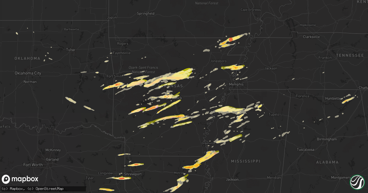
Hail Map in Arkansas on April 19, 2015
Get this storm
April 19 map
$229
one time, instant access
Download today. No call, no setup
Keep the $229
Bought the map and want the full workflow? Apply the entire $229 to a subscription within 7 days. None of it is wasted.
Every map, not just this one
This buys you this map. Subscription and you get every map we run, in the markets you choose from a few cities to whole states to nationwide. Plus real-time alerts the moment a storm fires.
Contact data
Name, contact info, occupancy, even credit band for addresses in the footprint. You go from where it hit to who to call.
Become the source they trust
Unlimited branding weather history reports on demand. You already have the documented answer ready for the property owner, and you are the one who showed up with it.
Property data and RoofTrace estimates
Pull up any address you have got, its value and the exact code rules for that jurisdiction, straight from One Click Code. Then RoofTrace estimates the squares, pitch, and roof value, priced the way you price.
Storm reports in Arkansas
Arkansas
| Date | Description |
|---|---|
| 04/19/20156:58 PM CDT | A local report indicates 1.75 inch wind near PINE BLUFF |
| 04/19/20156:55 PM CDT | A local report indicates 2.00 inch wind near SULPHUR SPRINGS |
| 04/19/20156:49 PM CDT | A local report indicates 1.00 inch wind near SULPHUR SPRINGS |
| 04/19/20156:45 PM CDT | A local report indicates 1.00 inch wind near LETONA |
| 04/19/20156:43 PM CDT | Trees down on highway 16. |
| 04/19/20156:43 PM CDT | A local report indicates 1.00 inch wind near EAST END |
| 04/19/20156:37 PM CDT | A local report indicates 1.00 inch wind near HEBER SPRINGS |
| 04/19/20156:33 PM CDT | Power lines down 1 block south of u.s. Highway 64 on logan street near the intersection of arkansas highway 179. |
| 04/19/20156:28 PM CDT | A local report indicates 1.75 inch wind near ROSE BUD |
| 04/19/20156:16 PM CDT | A local report indicates 1.00 inch wind near BENTON |
| 04/19/20156:15 PM CDT | Near exit 113 on interstate 30. |
| 04/19/20156:14 PM CDT | 12 inch diamter tree down in quitman. |
| 04/19/20156:08 PM CDT | A local report indicates 1.00 inch wind near GUY |
| 04/19/20156:02 PM CDT | A local report indicates 1.00 inch wind near GREENBRIER |
| 04/19/20155:55 PM CDT | A local report indicates 1.00 inch wind near MORRILTON |
| 04/19/20155:55 PM CDT | A local report indicates 1.50 inch wind near MALVERN |
| 04/19/20155:35 PM CDT | Pea to quarter sized hail fell and covered the ground. Leaves were stripped from trees...and gardens were damaged. |
| 04/19/20155:35 PM CDT | A local report indicates 1.00 inch wind near BLACKWELL |
| 04/19/20155:35 PM CDT | A local report indicates 2.75 inch wind near 1 SE HOT SPRINGS |
| 04/19/20155:35 PM CDT | Trees and power lines down...and some damage to buildings. |
| 04/19/20155:34 PM CDT | Damage mainly consisted of snapped or uprooted trees. There was also minor damage to outbuildings and chicken houses. |
| 04/19/20155:30 PM CDT | A local report indicates 1.50 inch wind near LAKE HAMILTON |
| 04/19/20155:30 PM CDT | A local report indicates 1.75 inch wind near HOT SPRINGS |
| 04/19/20155:26 PM CDT | A local report indicates 1.00 inch wind near HOT SPRINGS |
| 04/19/20155:15 PM CDT | Hail fell 5 miles southwest of hot springs memorial field. |
| 04/19/20155:13 PM CDT | A local report indicates 1.00 inch wind near PRESCOTT |
| 04/19/20155:05 PM CDT | A local report indicates 1.00 inch wind near 3 WNW GURDON |
| 04/19/20154:55 PM CDT | A local report indicates 1.00 inch wind near DARDANELLE |
| 04/19/20154:44 PM CDT | A local report indicates 2.75 inch wind near 3 N GLENWOOD |
| 04/19/20154:35 PM CDT | A local report indicates 2.00 inch wind near CADDO GAP |
| 04/19/20154:35 PM CDT | Golf ball sized hail covering ground on twin bridges road. Numerous reports of damage to roofs and vehicles. |
| 04/19/20154:32 PM CDT | Also reported a wall cloud visible to the northwest. |
| 04/19/20154:20 PM CDT | A local report indicates 1.75 inch wind near MT MAGAZINE |
| 04/19/20154:05 PM CDT | A local report indicates 1.00 inch wind near MAGAZINE |
| 04/19/20153:45 PM CDT | A local report indicates 1.75 inch wind near HUNTINGTON |
| 04/19/20153:42 PM CDT | A local report indicates 1.75 inch wind near WITCHERVILLE |
| 04/19/20153:38 PM CDT | From twitter...time estimated by radar. |
| 04/18/20158:59 PM CDT | Golfball sized hail and estimated 60 mph wind. |
| 04/18/20158:57 PM CDT | A local report indicates 1.00 inch wind near WILSON |
| 04/18/20158:40 PM CDT | Power lines down with power outages. |
| 04/18/20158:26 PM CDT | A local report indicates 60 MPH wind near TRUMANN |
| 04/18/20158:20 PM CDT | A local report indicates 1.00 inch wind near GALLOWAY |
| 04/18/20158:18 PM CDT | A local report indicates 1.00 inch wind near JACKSONVILLE |
| 04/18/20158:10 PM CDT | Tree down on 611 road. |
| 04/18/20158:10 PM CDT | Numerous trees down and an awning knocked over. |
| 04/18/20158:10 PM CDT | At the interstate 40/interstate 430 split. |
| 04/18/20158:05 PM CDT | At the intersection of highway 10/cantrell road and taylor loop. |
| 04/18/20158:00 PM CDT | Golf ball hail reported near corning via emergency manager. Time estimated using radar. |
| 04/18/20157:58 PM CDT | A local report indicates 1.50 inch wind near WEST LITTLE ROCK |
| 04/18/20157:55 PM CDT | A local report indicates 1.75 inch wind near 2 N CHENAL VALLEY |
| 04/18/20157:52 PM CDT | A local report indicates 1.00 inch wind near 5 N AVILLA |
| 04/18/20157:48 PM CDT | A local report indicates 1.75 inch wind near FERNDALE |
| 04/18/20157:45 PM CDT | A local report indicates 1.00 inch wind near STAR CITY |
| 04/18/20157:44 PM CDT | Estimated 70 mph wind gusts. Trees snapped or uprooted. |
| 04/18/20157:32 PM CDT | A local report indicates 1.00 inch wind near GLENDALE |
| 04/18/20157:31 PM CDT | Estimated 60 mph wind. |
| 04/18/20157:12 PM CDT | A local report indicates 1.00 inch wind near 4 NE CONWAY |
| 04/18/20157:10 PM CDT | A local report indicates 1.00 inch wind near RISON |
| 04/18/20157:10 PM CDT | A local report indicates 1.00 inch wind near SPRINGHILL |
| 04/18/20157:08 PM CDT | A local report indicates 1.00 inch wind near WOOSTER |
| 04/18/20157:05 PM CDT | A local report indicates 1.00 inch wind near 2 S PINE BLUFF |
| 04/18/20157:04 PM CDT | A local report indicates 1.25 inch wind near TOLTEC |
| 04/18/20157:02 PM CDT | Large tree limbs down. |
All States Impacted by Hail Map on April 19, 2015
Cities Impacted by Hail Map on April 19, 2015
- Burnsville, MS
- Hot Springs National Park, AR
- Pearcy, AR
- Malvern, AR
- Rayville, LA
- Pioneer, LA
- Oak Grove, LA
- Oak Ridge, LA
- Mer Rouge, LA
- Collinston, LA
- Converse, LA
- Piggott, AR
- Saint Francis, AR
- Campbell, MO
- Chappell Hill, TX
- Brenham, TX
- Washington, TX
- Heth, AR
- Cave City, AR
- Foley, AL
- Marianna, AR
- Oakland, MS
- Batesville, MS
- Enid, MS
- Courtland, MS
- Pope, MS
- Bastrop, TX
- Knobel, AR
- Pollard, AR
- Clarkton, MO
- Malden, MO
- Parma, MO
- Corning, AR
- Rector, AR
- Gideon, MO
- Weimar, TX
- Columbus, TX
- Murfreesboro, AR
- Amity, AR
- Houston, TX
- Sugar Land, TX
- Dayton, TX
- Nacogdoches, TX
- Alvin, TX
- Liverpool, TX
- Schulenburg, TX
- Brookshire, TX
- Wallis, TX
- Cat Spring, TX
- Sealy, TX
- Fulshear, TX
- Shreveport, LA
- De Berry, TX
- Marshall, TX
- Bethany, LA
- Waskom, TX
- Keithville, LA
- Ozark, AL
- La Grange, TX
- Alleyton, TX
- Garwood, TX
- Glidden, TX
- Palestine, AR
- Colt, AR
- Lexington, TX
- Crockett, TX
- Spring, TX
- Conroe, TX
- Hallettsville, TX
- Sublime, TX
- Little Rock, AR
- Wallisville, TX
- Anahuac, TX
- Wilson, AR
- Marked Tree, AR
- Dyess, AR
- Osceola, AR
- Keiser, AR
- Henning, TN
- Lepanto, AR
- Pittsburg, OK
- Kiowa, OK
- Benton, LA
- North Zulch, TX
- Iola, TX
- Timpson, TX
- Garrison, TX
- Shelbyville, TX
- Belmont, LA
- Pleasant Hill, LA
- Marthaville, LA
- Cushing, TX
- Center, TX
- Zwolle, LA
- Tenaha, TX
- Robeline, LA
- Neelyville, MO
- White Hall, AR
- Pine Bluff, AR
- Colfax, LA
- Lena, LA
- Havana, AR
- Blue Mountain, AR
- New Blaine, AR
- Magazine, AR
- Booneville, AR
- Delaware, AR
- Dardanelle, AR
- Paris, AR
- Lake Providence, LA
- Thaxton, MS
- Mabelvale, AR
- Vidalia, LA
- Woodville, MS
- Center Point, LA
- Deville, LA
- Jonesville, LA
- Effie, LA
- Marksville, LA
- Monterey, LA
- Crosby, MS
- Acme, LA
- Clayton, GA
- Dry Prong, LA
- Boyce, LA
- Pineville, LA
- Ball, LA
- Pollock, LA
- Grayson, LA
- Doddridge, AR
- Glen Allan, MS
- Mayersville, MS
- Chatham, MS
- Greenville, MS
- Anguilla, MS
- Hollandale, MS
- Rolling Fork, MS
- Pond Creek, OK
- Hackett, AR
- Wister, OK
- Mansfield, AR
- Huntington, AR
- Greenwood, AR
- Poteau, OK
- Cameron, OK
- Midland, AR
- Hartford, AR
- Lafe, AR
- Kirbyville, TX
- Conway, AR
- Wooster, AR
- Greenbrier, AR
- Mangham, LA
- Heber Springs, AR
- Lambert, MS
- Cloutierville, LA
- Provencal, LA
- Ponte Vedra Beach, FL
- Plainview, AR
- Carthage, AR
- Gary, TX
- Katy, TX
- Smithville, TX
- Charleston, MS
- Moulton, TX
- Shiner, TX
- Greenwood, MS
- Carrollton, MS
- San Augustine, TX
- Benton, AR
- Glenwood, AR
- Oxford, MS
- Mount Enterprise, TX
- Long Branch, TX
- Paragould, AR
- Marmaduke, AR
- Clarksville, AR
- Sheridan, AR
- Leola, AR
- Grapevine, AR
- Cecil, AR
- Charleston, AR
- Ozark, AR
- Earle, AR
- Widener, AR
- Mount Ida, AR
- Etta, MS
- Monroe, LA
- Columbia, LA
- Sledge, MS
- Sardis, MS
- Crenshaw, MS
- Tomball, TX
- Pinehurst, TX
- Magnolia, TX
- Cypress, TX
- Jessieville, AR
- Waller, TX
- Navasota, TX
- Hempstead, TX
- Crosby, TX
- Hattieville, AR
- Danville, AR
- Pottsville, AR
- Atkins, AR
- Abbeville, MS
- Okolona, MS
- Aberdeen, MS
- Huntsville, TX
- Bedias, TX
- Laneville, TX
- Henderson, TX
- West Point, MS
- Columbus, MS
- Burton, TX
- Ledbetter, TX
- Wardville, OK
- Atlanta, TX
- Somerville, TX
- Caldwell, TX
- Bokoshe, OK
- Shady Point, OK
- Winona, MS
- Pocahontas, AR
- Black Rock, AR
- Weiner, AR
- Harrisburg, AR
- Fisher, AR
- Dundee, MS
- Helena, AR
- Marks, MS
- Friars Point, MS
- Coahoma, MS
- Clarksdale, MS
- Waldron, AR
- Myrtle, MS
- Hankamer, TX
- Pearland, TX
- Manvel, TX
- Fresno, TX
- Rosharon, TX
- Itta Bena, MS
- Moorhead, MS
- Sunflower, MS
- Indianola, MS
- Baytown, TX
- Prescott, AR
- Wabbaseka, AR
- Scottsboro, AL
- Woodville, AL
- Pangburn, AR
- Cleveland, AR
- Clinton, AR
- Tumbling Shoals, AR
- Mount Vernon, AR
- Center Ridge, AR
- Judsonia, AR
- Rose Bud, AR
- Romance, AR
- Searcy, AR
- Enola, AR
- Springfield, AR
- Pleasant Plains, AR
- Wilburn, AR
- Belleville, AR
- Floral, AR
- Guy, AR
- Solgohachia, AR
- Damascus, AR
- Quitman, AR
- Drasco, AR
- Bee Branch, AR
- Star City, AR
- Devers, TX
- Porter, TX
- Huffman, TX
- New Caney, TX
- Winnie, TX
- Liberty, TX
- Kingwood, TX
- Humble, TX
- Millington, TN
- Drummonds, TN
- Bryan, TX
- Highlands, TX
- Bivins, TX
- Bonnerdale, AR
- Caddo Gap, AR
- Potts Camp, MS
- Hickory Flat, MS
- Pontotoc, MS
- Gould, AR
- Yorktown, AR
- Ponca, AR
- Subiaco, AR
- Scranton, AR
- Langley, AR
- Channelview, TX
- Pasadena, TX
- Galena Park, TX
- Jennings, OK
- Maramec, OK
- Madisonville, TX
- New Llano, LA
- Anacoco, LA
- Fort Polk, LA
- Leesville, LA
- Hornbeck, LA
- Plumerville, AR
- Coalgate, OK
- Stevenson, AL
- Flat Rock, AL
- Hollywood, AL
- Grant, AL
- Pisgah, AL
- Greenway, AR
- Gibson, MO
- Peach Orchard, AR
- Catron, MO
- Lilbourn, MO
- Delaplaine, AR
- Houston, AR
- Perry, AR
- Morrilton, AR
- Perryville, AR
- Mayflower, AR
- Roland, AR
- Gurdon, AR
- Okolona, AR
- Stilwell, OK
- Bunch, OK
- Forrest City, AR
- Madison, AR
- Many, LA
- Lyons, TX
- Grady, AR
- Rison, AR
- Arkadelphia, AR
- Altheimer, AR
- Stuart, OK
- Yates Center, KS
- North Little Rock, AR
- Rusk, TX
- Philipp, MS
- Minter City, MS
- Wheatley, AR
- Brinkley, AR
- Moro, AR
- Belcher, LA
- Hockley, TX
- Montgomery, TX
- Waynesboro, TN
- Olivehill, TN
- Kelly, LA
- Olla, LA
- Minden, LA
- Cotton Valley, LA
- Haughton, LA
- Mooringsport, LA
- Deer, AR
- Pettigrew, AR
- Kingston, AR
- Bradford, AR
- London, AR
- Dover, AR
- Russellville, AR
- Knoxville, AR
- Lamar, AR
- Ola, AR
- Casa, AR
- McCarley, MS
- Bismarck, AR
- Schlater, MS
- Ruleville, MS
- Holcomb, MS
- Grenada, MS
- Rosanky, TX
- Red Rock, TX
- Cedar Creek, TX
- Montgomery, LA
- Memphis, TN
- Houston, MS
- Elaine, AR
- Washington, AR
- Arlington, TN
- Gonzales, TX
- Longton, KS
- Elk Falls, KS
- Tatum, TX
- Palm Coast, FL
- Saint Augustine, FL
- Crane Hill, AL
- Vian, OK
- Stigler, OK
- Holcomb, MO
- Maumelle, AR
- Spivey, KS
- Kingman, KS
- Midway, TX
- Carbon Hill, AL
- Eldridge, AL
- Jesup, GA
- Vilonia, AR
- Natchez, LA
- Melrose, LA
- Natchitoches, LA
- Dime Box, TX
- Paron, AR
- Blevins, AR
- Richmond, TX
- Hamshire, TX
- Cullman, AL
- Santa Rosa Beach, FL
- Amory, MS
- Stuttgart, AR
- De Witt, AR
- Brunswick, GA
- Hortense, GA
- Arley, AL
- Parthenon, AR
- Winnfield, LA
- Tullos, LA
- Spurger, TX
- Imboden, AR
- Walnut Ridge, AR
- Gilliam, LA
- Scott, AR
- Sparkman, AR
- New Ulm, TX
- Atlanta, LA
- Flatwoods, LA
- Mora, LA
- Florien, LA
- Fisher, LA
- Trenton, AL
- Water Valley, MS
- Crumrod, AR
- Culleoka, TN
- Kingsland, AR
- Hensley, AR
- Trumann, AR
- Gillett, AR
- Almyra, AR
- Harper, KS
- Vivian, LA
- Winnsboro, LA
- Baskin, LA
- Joaquin, TX
- East Bernard, TX
- Logan, AL
- Letona, AR
- Augusta, AR
- Alligator, MS
- Snow Lake, AR
- Mellwood, AR
- Carmine, TX
- Giddings, TX
- West Helena, AR
- Traskwood, AR
- Poyen, AR
- Bauxite, AR
- England, AR
- Frenchmans Bayou, AR
- Bassett, AR
- Joiner, AR
- Abbeville, AL
- Epps, LA
- Delhi, LA
- Lovelady, TX
- Beckville, TX
- Summers, AR
- Westville, OK
- Lonsdale, AR
- Birmingham, AL
- Ratcliff, AR
- Lamont, OK
- Deer Creek, OK
- Resaca, GA
- Ranger, GA
- Palatka, FL
- Florahome, FL
- Snow, OK
- Rattan, OK
- Scobey, MS
- Cascilla, MS
- Tillatoba, MS
- Coffeeville, MS
- Belzoni, MS
- Bastrop, LA
- West Point, TX
- Lexa, AR
- Winfield, KS
- Caledonia, MS
- Sulligent, AL
- Steens, MS
- Vernon, AL
- Bryant, AR
- Albertville, AL
- Duck Hill, MS
- Starkville, MS
- Roe, AR
- Ponte Vedra, FL
- Riceboro, GA
- Royal, AR
- Mountain Pine, AR
- Tonkawa, OK
- Alexander, AR
- Etowah, TN
- Burkeville, TX
- Paint Rock, AL
- Stringtown, OK
- Watson, AR
- Saint Charles, AR
- Ethel, AR
- Covington, TN
- Skipperville, AL
- Newville, AL
- Oil Trough, AR
- Waterford, MS
- Marvell, AR
- Poplar Grove, AR
- Silver Springs, FL
- Randolph, MS
- Cushing, OK
- Stroud, OK
- Tryon, OK
- Hagarville, AR
- Wiergate, TX
- Yale, OK
- Kennard, TX
- Apple Springs, TX
- Fackler, AL
- Sidon, MS
- Leland, MS
- Isola, MS
- Inverness, MS
- Powhatan, AR
- Smithville, AR
- Bigelow, AR
- Hot Springs Village, AR
- Trinity, TX
- Dodson, LA
- Groveton, TX
- Camden, AR
- Ludowici, GA
- Rosston, AR
- Satellite Beach, FL
- Indialantic, FL
- Merritt Island, FL
- Ecru, MS
- Bald Knob, AR
- Jerusalem, AR
- Taylor, AR
- Kyle, TX
- Dale, TX
- Lockhart, TX
- Blountsville, AL
- Horton, AL
- Guntersville, AL
- Beedeville, AR
- McCrory, AR
- Kirby, AR
- Lavaca, AR
- Aubrey, AR
- Ripley, OK
- Alexandria, LA
- Cotton Plant, AR
- Goodwin, AR
- Wynne, AR
- Glennville, GA
- Checotah, OK
- Stafford, TX
- Missouri City, TX
- Jasper, TX
- Adona, AR
- Fayetteville, TX
- Lynn, AL
- Fort Smith, AR
- New Madrid, MO
- Sikes, LA
- West Monroe, LA
- Beaumont, TX
- Douglass, TX
- Como, MS
- Lyon, MS
- Tutwiler, MS
- Concord, AR
- Flatonia, TX
- Muldoon, TX
- Jena, LA
- Sherwood, AR
- Jacksonville, AR
- Little Rock Air Force Base, AR


