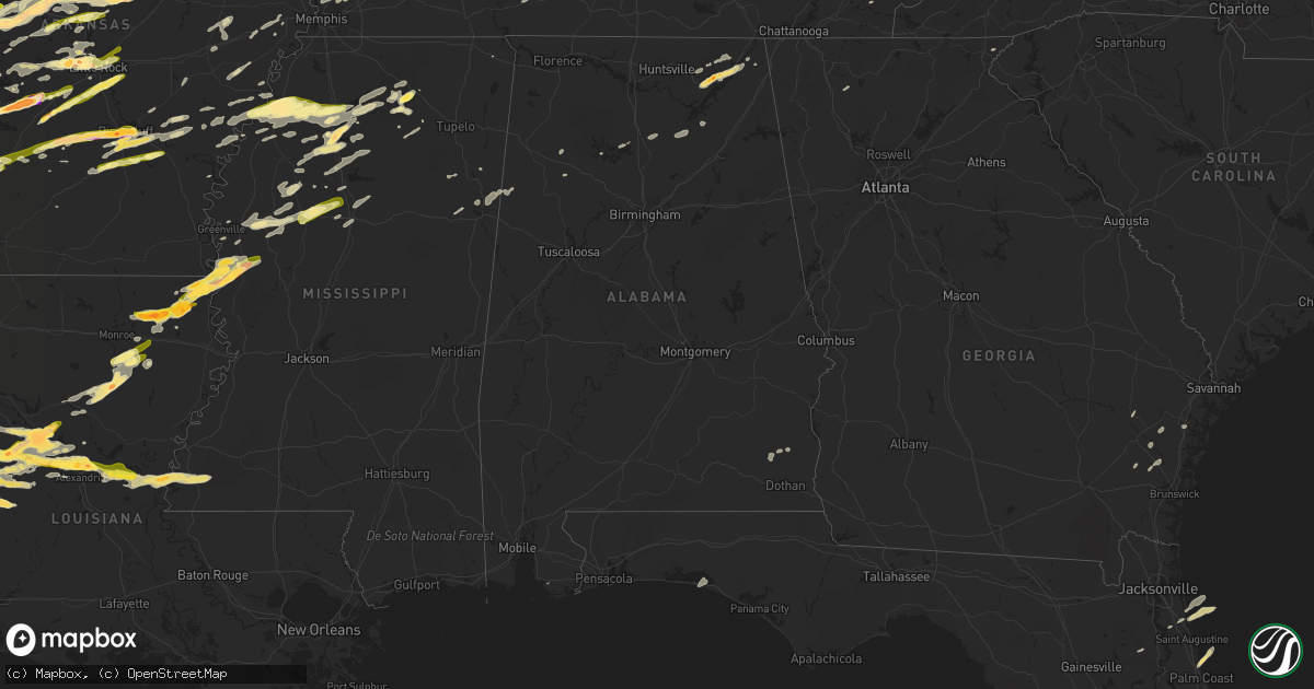
Hail Map in Alabama on April 19, 2015
Get this storm
April 19 map
$229
one time, instant access
Download today. No call, no setup
Keep the $229
Bought the map and want the full workflow? Apply the entire $229 to a subscription within 7 days. None of it is wasted.
Every map, not just this one
This buys you this map. Subscription and you get every map we run, in the markets you choose from a few cities to whole states to nationwide. Plus real-time alerts the moment a storm fires.
Contact data
Name, contact info, occupancy, even credit band for addresses in the footprint. You go from where it hit to who to call.
Become the source they trust
Unlimited branding weather history reports on demand. You already have the documented answer ready for the property owner, and you are the one who showed up with it.
Property data and RoofTrace estimates
Pull up any address you have got, its value and the exact code rules for that jurisdiction, straight from One Click Code. Then RoofTrace estimates the squares, pitch, and roof value, priced the way you price.
Storm reports in Alabama
Alabama
| Date | Description |
|---|---|
| 04/19/20155:13 PM CDT | A local report indicates 1.25 inch wind near SCOTTSBORO |
| 04/19/20155:10 PM CDT | Golf ball hail in scottsboro on long hollow road. |
| 04/19/20155:10 PM CDT | A local report indicates 1.00 inch wind near SCOTTSBORO |
| 04/19/20154:39 PM CDT | Large limbs down on melbourne ave in huntsville |
| 04/19/20154:32 PM CDT | Trees down on papas hill road. |
| 04/19/20154:30 PM CDT | Large limb down at the intersection of bradford and explorer in huntsville |
| 04/19/20154:29 PM CDT | Large tree fell on a home at 4519 sparkman dr in huntsville |
| 04/19/20154:25 PM CDT | Trees down on oak ridge drive. |
| 04/19/20154:25 PM CDT | Tree and power lines down on bell factory road in moores mill. |
| 04/19/20154:25 PM CDT | Tree and power lines down on bell factory road and st. Clair lane in moores mill. |
| 04/19/20154:17 PM CDT | Tree down on powerlines at 2205 11th street in huntsville |
| 04/19/20153:57 PM CDT | Numerous trees down in mountain brook. |
| 04/19/201510:07 AM CDT | Trees blown down along bodiford road near pansey alabama. Nearby structure also possibly damaged. Photo posted to wdhn-tv facebook page. Time estimated from radar. |
| 04/19/201510:02 AM CDT | Trees down at south rocky creek road and womack road |
| 04/19/20159:58 AM CDT | Possible tornado. Damage from madrid to cottonwood to gordon areas in southern houston county. 5 homes significantly damaged...and 20 to 30 more with some roof damage. |
| 04/19/20159:54 AM CDT | Trees down near highway 231 south near the state line. |
| 04/19/20159:26 AM CDT | An ef-1 tornado moved across the alabama georgia state line and tracked across southern fort benning. Multiple trees were downed. The tornado lifted approximately 7 min |
| 04/19/20159:17 AM CDT | The tornado touched down south of county road 18 just west of highwsy 165. The tornado tracked northeast and crossed highway 165...and caused structural damage to sever |
| 04/19/20159:17 AM CDT | Structural damage reported near intersection of hwy 165 and oswichee rd. Extent of damage unknown at this time. Possible tornado. Time estimated from radar. |
| 04/19/20159:15 AM CDT | Trees and power lines blown down along county road 47 near shorterville. Public post to wtvy-tv facebook. |
| 04/19/20159:00 AM CDT | Tree down along pebble creek road |
| 04/19/20159:00 AM CDT | Tree down along logan road |
| 04/19/20159:00 AM CDT | Tree down along deese road |
| 04/19/20158:57 AM CDT | Several power lines down around abbeville. Possible tornado just south of abbeville based on dual pol data from eox |
| 04/19/20158:55 AM CDT | Tree down on myrtle road. |
| 04/19/20158:51 AM CDT | State trooper reported train cars overturned near highway 431...mile marker 38. |
| 04/19/20158:46 AM CDT | Preliminary data supports at least an ef1 tornado with damage path from 31.5135 -85.3112 at 846 am cdt to 31.5302 -85.2815 at 853 am cdt. Damage to trees with five rail |
| 04/19/20158:43 AM CDT | The tornado touched down in a very rural portion of southwest russell county...near the barbour county line along perrys well road. The tornado traveled northeast appro |
| 04/19/20158:42 AM CDT | Tree down on antler drive |
| 04/19/20158:40 AM CDT | Several large trees downed. Time estimated from radar. Report via a wtvy-tv web report. Corrected time. |
| 04/19/20158:38 AM CDT | The tornado touched down along keener dr just northwest of the city of leesburg. Multiple trees were snapped or uprooted...and unfortunately one tree fell onto a reside |
| 04/19/20158:35 AM CDT | Multiple trees down along pleasant valley rd. Also damage to agricultural buildings at pleasant valley high school. Updated report. |
| 04/19/20158:30 AM CDT | Numerous trees down in leesburg. Also damage to a barn and house. Corrected report. |
| 04/19/20158:30 AM CDT | Numerous trees down in leesburg |
| 04/19/20157:46 AM CDT | Preliminary data supports at least an ef1 tornado with damage path from 31.5135...-85.3112 at 846 am cdt to 31.5302...-85.2815 at 853 am cdt. Damage to trees with five rail ( |
| 04/19/20157:19 AM CDT | The tornado touched down in a pecan grove west of peachburg plantation...uprooting a mature healthy pecan tree. It travelled northeast paralleling peachburg road...snap |
| 04/19/20153:40 AM CDT | Tree fell on mobile home. |
| 04/19/20153:20 AM CDT | Power outage on highway 117 in ider. |
| 04/19/20153:02 AM CDT | Tree knocked down onto a mobile home in geraldine. |
| 04/19/20152:58 AM CDT | Large tree down on darlington road in huntsville. |
| 04/19/20152:52 AM CDT | Two trees were downed due to thunderstorm winds. |
| 04/19/20152:51 AM CDT | Tree down at pulaski and wall triana in nw huntsville. |
| 04/19/20152:44 AM CDT | Tree down on hwy 231 and steger road. |
| 04/19/20152:42 AM CDT | Tree down at 116 darlington in huntsville. |
| 04/19/20152:36 AM CDT | Quarter size hail 3 miles north of hwy 278 on highway 79. |
| 04/19/20152:20 AM CDT | A few trees were downed by thunderstorm winds. |
| 04/19/20152:11 AM CDT | A few trees were downed by thunderstorm winds. |
| 04/19/20152:11 AM CDT | Tree and power lines down on wooley springs road. |
| 04/19/20152:11 AM CDT | Power outage in hazel green. |
| 04/19/20152:11 AM CDT | Several trees were downed and a couple of buildings had some tin peeled back from roofs due to thunderstorm winds. |
| 04/19/20152:08 AM CDT | Large tree down on oneal road. |
| 04/19/20152:05 AM CDT | Trees down on highway 53 and dan crutcher road. |
| 04/19/20152:05 AM CDT | A tree was knocked down on steger road at highway 231. |
| 04/19/20152:03 AM CDT | Large tree down on darlington road in huntsville. |
| 04/19/20152:01 AM CDT | Trees down on monroe... Nunley... And bobo section roads. |
| 04/19/20151:49 AM CDT | Tree on road on pulaski pike just east of wall triana highway. |
| 04/19/20151:49 AM CDT | Tree down at pulaski and wall triana in nw huntsville. |
| 04/19/20151:47 AM CDT | A large tree was uprooted on 6th street 3 blocks east of highway 251. Time estimated by radar. |
| 04/19/20151:45 AM CDT | Ef0 with maximum wind speeds of 75 mph. Path length 0.76 miles. Path width up to 100 yards. Surveyed by ua-huntsville atmospheric science department / swirll. Tree dama |
| 04/19/20151:45 AM CDT | A 300 yard path of damage was reported at a residence on bridges road in northeast limestone county. It was reported that several pine trees snaped and uprooted. |
| 04/19/20151:42 AM CDT | Tree and power lines down on wooley springs road. |
| 04/19/20151:37 AM CDT | In the piney chapel community...minor roof damage and several trees down on loggins road. Major damage to home from two large trees being knocked down. One shed destroy |
| 04/19/20151:32 AM CDT | Large tree down on oneal road. |
| 04/19/20151:30 AM CDT | In the owens community...trees were blown down off easter ferry road. |
| 04/19/20151:30 AM CDT | A tree was knocked down on zehner road in the blackburn community. |
| 04/19/20151:30 AM CDT | In the owens community....trees were blown down off easter ferry road. |
| 04/19/20151:25 AM CDT | Thunderstorm winds knocked a tree onto a roof on blue springs drive. Trees and power lines were knocked down on davis road and beechwood road. |
| 04/19/20151:25 AM CDT | In the lentzville community...trees were knocked down in lakeside estates. |
| 04/19/20151:15 AM CDT | A few large limbs were downed due to thunderstorm winds. |
| 04/19/20151:00 AM CDT | Several trees were downed by thunderstorm winds. |
| 04/19/201512:53 AM CDT | One tree and a few branches down near the vicinity of cr 22...cr 20...and cr 63. Tin off of a garage in the area as well. |
| 04/19/201512:37 AM CDT | Several trees were blown down. |
| 04/18/20158:40 PM CDT | Several large trees downed. Time estimated from radar. Report via a wtvy-tv web report. |
All States Impacted by Hail Map on April 19, 2015
Cities Impacted by Hail Map on April 19, 2015
- Burnsville, MS
- Hot Springs National Park, AR
- Pearcy, AR
- Malvern, AR
- Rayville, LA
- Pioneer, LA
- Oak Grove, LA
- Oak Ridge, LA
- Mer Rouge, LA
- Collinston, LA
- Converse, LA
- Piggott, AR
- Saint Francis, AR
- Campbell, MO
- Chappell Hill, TX
- Brenham, TX
- Washington, TX
- Heth, AR
- Cave City, AR
- Foley, AL
- Marianna, AR
- Oakland, MS
- Batesville, MS
- Enid, MS
- Courtland, MS
- Pope, MS
- Bastrop, TX
- Knobel, AR
- Pollard, AR
- Clarkton, MO
- Malden, MO
- Parma, MO
- Corning, AR
- Rector, AR
- Gideon, MO
- Weimar, TX
- Columbus, TX
- Murfreesboro, AR
- Amity, AR
- Houston, TX
- Sugar Land, TX
- Dayton, TX
- Nacogdoches, TX
- Alvin, TX
- Liverpool, TX
- Schulenburg, TX
- Brookshire, TX
- Wallis, TX
- Cat Spring, TX
- Sealy, TX
- Fulshear, TX
- Shreveport, LA
- De Berry, TX
- Marshall, TX
- Bethany, LA
- Waskom, TX
- Keithville, LA
- Ozark, AL
- La Grange, TX
- Alleyton, TX
- Garwood, TX
- Glidden, TX
- Palestine, AR
- Colt, AR
- Lexington, TX
- Crockett, TX
- Spring, TX
- Conroe, TX
- Hallettsville, TX
- Sublime, TX
- Little Rock, AR
- Wallisville, TX
- Anahuac, TX
- Wilson, AR
- Marked Tree, AR
- Dyess, AR
- Osceola, AR
- Keiser, AR
- Henning, TN
- Lepanto, AR
- Pittsburg, OK
- Kiowa, OK
- Benton, LA
- North Zulch, TX
- Iola, TX
- Timpson, TX
- Garrison, TX
- Shelbyville, TX
- Belmont, LA
- Pleasant Hill, LA
- Marthaville, LA
- Cushing, TX
- Center, TX
- Zwolle, LA
- Tenaha, TX
- Robeline, LA
- Neelyville, MO
- White Hall, AR
- Pine Bluff, AR
- Colfax, LA
- Lena, LA
- Havana, AR
- Blue Mountain, AR
- New Blaine, AR
- Magazine, AR
- Booneville, AR
- Delaware, AR
- Dardanelle, AR
- Paris, AR
- Lake Providence, LA
- Thaxton, MS
- Mabelvale, AR
- Vidalia, LA
- Woodville, MS
- Center Point, LA
- Deville, LA
- Jonesville, LA
- Effie, LA
- Marksville, LA
- Monterey, LA
- Crosby, MS
- Acme, LA
- Clayton, GA
- Dry Prong, LA
- Boyce, LA
- Pineville, LA
- Ball, LA
- Pollock, LA
- Grayson, LA
- Doddridge, AR
- Glen Allan, MS
- Mayersville, MS
- Chatham, MS
- Greenville, MS
- Anguilla, MS
- Hollandale, MS
- Rolling Fork, MS
- Pond Creek, OK
- Hackett, AR
- Wister, OK
- Mansfield, AR
- Huntington, AR
- Greenwood, AR
- Poteau, OK
- Cameron, OK
- Midland, AR
- Hartford, AR
- Lafe, AR
- Kirbyville, TX
- Conway, AR
- Wooster, AR
- Greenbrier, AR
- Mangham, LA
- Heber Springs, AR
- Lambert, MS
- Cloutierville, LA
- Provencal, LA
- Ponte Vedra Beach, FL
- Plainview, AR
- Carthage, AR
- Gary, TX
- Katy, TX
- Smithville, TX
- Charleston, MS
- Moulton, TX
- Shiner, TX
- Greenwood, MS
- Carrollton, MS
- San Augustine, TX
- Benton, AR
- Glenwood, AR
- Oxford, MS
- Mount Enterprise, TX
- Long Branch, TX
- Paragould, AR
- Marmaduke, AR
- Clarksville, AR
- Sheridan, AR
- Leola, AR
- Grapevine, AR
- Cecil, AR
- Charleston, AR
- Ozark, AR
- Earle, AR
- Widener, AR
- Mount Ida, AR
- Etta, MS
- Monroe, LA
- Columbia, LA
- Sledge, MS
- Sardis, MS
- Crenshaw, MS
- Tomball, TX
- Pinehurst, TX
- Magnolia, TX
- Cypress, TX
- Jessieville, AR
- Waller, TX
- Navasota, TX
- Hempstead, TX
- Crosby, TX
- Hattieville, AR
- Danville, AR
- Pottsville, AR
- Atkins, AR
- Abbeville, MS
- Okolona, MS
- Aberdeen, MS
- Huntsville, TX
- Bedias, TX
- Laneville, TX
- Henderson, TX
- West Point, MS
- Columbus, MS
- Burton, TX
- Ledbetter, TX
- Wardville, OK
- Atlanta, TX
- Somerville, TX
- Caldwell, TX
- Bokoshe, OK
- Shady Point, OK
- Winona, MS
- Pocahontas, AR
- Black Rock, AR
- Weiner, AR
- Harrisburg, AR
- Fisher, AR
- Dundee, MS
- Helena, AR
- Marks, MS
- Friars Point, MS
- Coahoma, MS
- Clarksdale, MS
- Waldron, AR
- Myrtle, MS
- Hankamer, TX
- Pearland, TX
- Manvel, TX
- Fresno, TX
- Rosharon, TX
- Itta Bena, MS
- Moorhead, MS
- Sunflower, MS
- Indianola, MS
- Baytown, TX
- Prescott, AR
- Wabbaseka, AR
- Scottsboro, AL
- Woodville, AL
- Pangburn, AR
- Cleveland, AR
- Clinton, AR
- Tumbling Shoals, AR
- Mount Vernon, AR
- Center Ridge, AR
- Judsonia, AR
- Rose Bud, AR
- Romance, AR
- Searcy, AR
- Enola, AR
- Springfield, AR
- Pleasant Plains, AR
- Wilburn, AR
- Belleville, AR
- Floral, AR
- Guy, AR
- Solgohachia, AR
- Damascus, AR
- Quitman, AR
- Drasco, AR
- Bee Branch, AR
- Star City, AR
- Devers, TX
- Porter, TX
- Huffman, TX
- New Caney, TX
- Winnie, TX
- Liberty, TX
- Kingwood, TX
- Humble, TX
- Millington, TN
- Drummonds, TN
- Bryan, TX
- Highlands, TX
- Bivins, TX
- Bonnerdale, AR
- Caddo Gap, AR
- Potts Camp, MS
- Hickory Flat, MS
- Pontotoc, MS
- Gould, AR
- Yorktown, AR
- Ponca, AR
- Subiaco, AR
- Scranton, AR
- Langley, AR
- Channelview, TX
- Pasadena, TX
- Galena Park, TX
- Jennings, OK
- Maramec, OK
- Madisonville, TX
- New Llano, LA
- Anacoco, LA
- Fort Polk, LA
- Leesville, LA
- Hornbeck, LA
- Plumerville, AR
- Coalgate, OK
- Stevenson, AL
- Flat Rock, AL
- Hollywood, AL
- Grant, AL
- Pisgah, AL
- Greenway, AR
- Gibson, MO
- Peach Orchard, AR
- Catron, MO
- Lilbourn, MO
- Delaplaine, AR
- Houston, AR
- Perry, AR
- Morrilton, AR
- Perryville, AR
- Mayflower, AR
- Roland, AR
- Gurdon, AR
- Okolona, AR
- Stilwell, OK
- Bunch, OK
- Forrest City, AR
- Madison, AR
- Many, LA
- Lyons, TX
- Grady, AR
- Rison, AR
- Arkadelphia, AR
- Altheimer, AR
- Stuart, OK
- Yates Center, KS
- North Little Rock, AR
- Rusk, TX
- Philipp, MS
- Minter City, MS
- Wheatley, AR
- Brinkley, AR
- Moro, AR
- Belcher, LA
- Hockley, TX
- Montgomery, TX
- Waynesboro, TN
- Olivehill, TN
- Kelly, LA
- Olla, LA
- Minden, LA
- Cotton Valley, LA
- Haughton, LA
- Mooringsport, LA
- Deer, AR
- Pettigrew, AR
- Kingston, AR
- Bradford, AR
- London, AR
- Dover, AR
- Russellville, AR
- Knoxville, AR
- Lamar, AR
- Ola, AR
- Casa, AR
- McCarley, MS
- Bismarck, AR
- Schlater, MS
- Ruleville, MS
- Holcomb, MS
- Grenada, MS
- Rosanky, TX
- Red Rock, TX
- Cedar Creek, TX
- Montgomery, LA
- Memphis, TN
- Houston, MS
- Elaine, AR
- Washington, AR
- Arlington, TN
- Gonzales, TX
- Longton, KS
- Elk Falls, KS
- Tatum, TX
- Palm Coast, FL
- Saint Augustine, FL
- Crane Hill, AL
- Vian, OK
- Stigler, OK
- Holcomb, MO
- Maumelle, AR
- Spivey, KS
- Kingman, KS
- Midway, TX
- Carbon Hill, AL
- Eldridge, AL
- Jesup, GA
- Vilonia, AR
- Natchez, LA
- Melrose, LA
- Natchitoches, LA
- Dime Box, TX
- Paron, AR
- Blevins, AR
- Richmond, TX
- Hamshire, TX
- Cullman, AL
- Santa Rosa Beach, FL
- Amory, MS
- Stuttgart, AR
- De Witt, AR
- Brunswick, GA
- Hortense, GA
- Arley, AL
- Parthenon, AR
- Winnfield, LA
- Tullos, LA
- Spurger, TX
- Imboden, AR
- Walnut Ridge, AR
- Gilliam, LA
- Scott, AR
- Sparkman, AR
- New Ulm, TX
- Atlanta, LA
- Flatwoods, LA
- Mora, LA
- Florien, LA
- Fisher, LA
- Trenton, AL
- Water Valley, MS
- Crumrod, AR
- Culleoka, TN
- Kingsland, AR
- Hensley, AR
- Trumann, AR
- Gillett, AR
- Almyra, AR
- Harper, KS
- Vivian, LA
- Winnsboro, LA
- Baskin, LA
- Joaquin, TX
- East Bernard, TX
- Logan, AL
- Letona, AR
- Augusta, AR
- Alligator, MS
- Snow Lake, AR
- Mellwood, AR
- Carmine, TX
- Giddings, TX
- West Helena, AR
- Traskwood, AR
- Poyen, AR
- Bauxite, AR
- England, AR
- Frenchmans Bayou, AR
- Bassett, AR
- Joiner, AR
- Abbeville, AL
- Epps, LA
- Delhi, LA
- Lovelady, TX
- Beckville, TX
- Summers, AR
- Westville, OK
- Lonsdale, AR
- Birmingham, AL
- Ratcliff, AR
- Lamont, OK
- Deer Creek, OK
- Resaca, GA
- Ranger, GA
- Palatka, FL
- Florahome, FL
- Snow, OK
- Rattan, OK
- Scobey, MS
- Cascilla, MS
- Tillatoba, MS
- Coffeeville, MS
- Belzoni, MS
- Bastrop, LA
- West Point, TX
- Lexa, AR
- Winfield, KS
- Caledonia, MS
- Sulligent, AL
- Steens, MS
- Vernon, AL
- Bryant, AR
- Albertville, AL
- Duck Hill, MS
- Starkville, MS
- Roe, AR
- Ponte Vedra, FL
- Riceboro, GA
- Royal, AR
- Mountain Pine, AR
- Tonkawa, OK
- Alexander, AR
- Etowah, TN
- Burkeville, TX
- Paint Rock, AL
- Stringtown, OK
- Watson, AR
- Saint Charles, AR
- Ethel, AR
- Covington, TN
- Skipperville, AL
- Newville, AL
- Oil Trough, AR
- Waterford, MS
- Marvell, AR
- Poplar Grove, AR
- Silver Springs, FL
- Randolph, MS
- Cushing, OK
- Stroud, OK
- Tryon, OK
- Hagarville, AR
- Wiergate, TX
- Yale, OK
- Kennard, TX
- Apple Springs, TX
- Fackler, AL
- Sidon, MS
- Leland, MS
- Isola, MS
- Inverness, MS
- Powhatan, AR
- Smithville, AR
- Bigelow, AR
- Hot Springs Village, AR
- Trinity, TX
- Dodson, LA
- Groveton, TX
- Camden, AR
- Ludowici, GA
- Rosston, AR
- Satellite Beach, FL
- Indialantic, FL
- Merritt Island, FL
- Ecru, MS
- Bald Knob, AR
- Jerusalem, AR
- Taylor, AR
- Kyle, TX
- Dale, TX
- Lockhart, TX
- Blountsville, AL
- Horton, AL
- Guntersville, AL
- Beedeville, AR
- McCrory, AR
- Kirby, AR
- Lavaca, AR
- Aubrey, AR
- Ripley, OK
- Alexandria, LA
- Cotton Plant, AR
- Goodwin, AR
- Wynne, AR
- Glennville, GA
- Checotah, OK
- Stafford, TX
- Missouri City, TX
- Jasper, TX
- Adona, AR
- Fayetteville, TX
- Lynn, AL
- Fort Smith, AR
- New Madrid, MO
- Sikes, LA
- West Monroe, LA
- Beaumont, TX
- Douglass, TX
- Como, MS
- Lyon, MS
- Tutwiler, MS
- Concord, AR
- Flatonia, TX
- Muldoon, TX
- Jena, LA
- Sherwood, AR
- Jacksonville, AR
- Little Rock Air Force Base, AR


