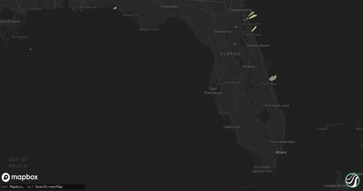
Hail Map in Florida on April 19, 2015
Get this storm
April 19 map
$229
one time, instant access
Download today. No call, no setup
Keep the $229
Bought the map and want the full workflow? Apply the entire $229 to a subscription within 7 days. None of it is wasted.
Every map, not just this one
This buys you this map. Subscription and you get every map we run, in the markets you choose from a few cities to whole states to nationwide. Plus real-time alerts the moment a storm fires.
Contact data
Name, contact info, occupancy, even credit band for addresses in the footprint. You go from where it hit to who to call.
Become the source they trust
Unlimited branding weather history reports on demand. You already have the documented answer ready for the property owner, and you are the one who showed up with it.
Property data and RoofTrace estimates
Pull up any address you have got, its value and the exact code rules for that jurisdiction, straight from One Click Code. Then RoofTrace estimates the squares, pitch, and roof value, priced the way you price.
Storm reports in Florida
Florida
| Date | Description |
|---|---|
| 04/19/20154:25 PM CDT | Numerous reports of fallen trees and minor structural damage in apopka. Pictures provided over social media via local media wftv indicate several large fallen tree bran |
| 04/19/20153:55 PM CDT | Trained spotter reported tree damage near williston. |
| 04/19/20153:45 PM CDT | Trees down at the intersection of sweet magnolia street and white oaks trace. |
| 04/19/20153:41 PM CDT | Weather spotter reported 60 mph winds. |
| 04/19/20153:35 PM CDT | Media received report with photo of a tree downed off of old kings road. |
| 04/19/20153:20 PM CDT | Power lines were blown down on fleming island. |
| 04/19/20153:10 PM CDT | A couple of trees were blown down across lake city. |
| 04/19/20153:00 PM CDT | Trees were blown down across the southern end of the county.the time of damage was based on radar. |
| 04/19/20152:25 PM CDT | A power line was blown down by thunderstorm winds. |
| 04/19/20152:23 PM CDT | Multiple trees downed around the mayo area including along county roads 351 and 354. Initially reported by 911 center...also reported by the public and relayed by wctv- |
| 04/19/20152:22 PM CDT | Large tree limb blown down at price road and state road 21. |
| 04/19/20152:20 PM CDT | Wind damage impacted a home and damaged the outdoor canopy. Cost of damage was unknown. The canopy was the only damage in the area. No tree damage was reported. |
| 04/19/20152:20 PM CDT | Resident reported a possible tornado. Large live oak down and numerous power lines down on 209th road near county road 252. |
| 04/19/20152:00 PM CDT | Several trees down on highway 19 near bill howell road |
| 04/19/20151:40 PM CDT | Tree down on woods creek road |
| 04/19/201512:47 PM CDT | Tree down on simpson rd. |
| 04/19/201512:00 PM CDT | Tree down on vehicle at meridian and maclay |
| 04/19/201511:58 AM CDT | Trees down at hermitage road and thomasville road |
| 04/19/201511:58 AM CDT | Trees down on lakeshore drive |
| 04/19/201511:51 AM CDT | Survey confirms ef1 tornado with max winds estimated near 95 mph from 30.4981...-84.3136 at 1251 pm edt to 30.5443...-84.2574 at 1259 pm edt. Sporadic tree damage along a w ( |
| 04/19/20159:52 AM CDT | Nws survey determines ef1 tornado with damage path from 30.98 -85.41 at 952 am cdt to 31.33 -84.90 2mi se of blakely georgia at 1138 am edt. This tornado began about a |
| 04/19/20159:50 AM CDT | Several pecan trees blown over. One tree destroyed a barn. |
| 04/19/20159:50 AM CDT | Large trees uprooted along highway 231 near campbellton and the alabama-florida state border. Report via wmbb-tv meteorologist. |
| 04/19/20159:20 AM CDT | Trees and power lines down in the northern part of washington county |
| 04/19/20158:42 AM CDT | Social media picture of trees down on highway 81 just north of highway 20. |
| 04/19/20158:25 AM CDT | Tree damage earlier reported by broadcast media determined to be associated with a tornado. Rated ef0. 1/4 mile damage path with trees and power lines downed along high |
| 04/19/20158:25 AM CDT | Possible tornado. 1/4 mi damage path with trees and power lines down near bruce along hwy 81 n. |
| 04/19/20158:22 AM CDT | Short ef0 tornado path confirmed by nws dual pol radar debris signature in a rural area west of bruce. Damage likely confined to trees. Estimated duration 3 minutes. Pa |
| 04/19/20157:38 AM CDT | Large tree snapped near the hilton sandestin. Via wmbb-tv meteorologist. |
All States Impacted by Hail Map on April 19, 2015
Cities Impacted by Hail Map on April 19, 2015
- Burnsville, MS
- Hot Springs National Park, AR
- Pearcy, AR
- Malvern, AR
- Rayville, LA
- Pioneer, LA
- Oak Grove, LA
- Oak Ridge, LA
- Mer Rouge, LA
- Collinston, LA
- Converse, LA
- Piggott, AR
- Saint Francis, AR
- Campbell, MO
- Chappell Hill, TX
- Brenham, TX
- Washington, TX
- Heth, AR
- Cave City, AR
- Foley, AL
- Marianna, AR
- Oakland, MS
- Batesville, MS
- Enid, MS
- Courtland, MS
- Pope, MS
- Bastrop, TX
- Knobel, AR
- Pollard, AR
- Clarkton, MO
- Malden, MO
- Parma, MO
- Corning, AR
- Rector, AR
- Gideon, MO
- Weimar, TX
- Columbus, TX
- Murfreesboro, AR
- Amity, AR
- Houston, TX
- Sugar Land, TX
- Dayton, TX
- Nacogdoches, TX
- Alvin, TX
- Liverpool, TX
- Schulenburg, TX
- Brookshire, TX
- Wallis, TX
- Cat Spring, TX
- Sealy, TX
- Fulshear, TX
- Shreveport, LA
- De Berry, TX
- Marshall, TX
- Bethany, LA
- Waskom, TX
- Keithville, LA
- Ozark, AL
- La Grange, TX
- Alleyton, TX
- Garwood, TX
- Glidden, TX
- Palestine, AR
- Colt, AR
- Lexington, TX
- Crockett, TX
- Spring, TX
- Conroe, TX
- Hallettsville, TX
- Sublime, TX
- Little Rock, AR
- Wallisville, TX
- Anahuac, TX
- Wilson, AR
- Marked Tree, AR
- Dyess, AR
- Osceola, AR
- Keiser, AR
- Henning, TN
- Lepanto, AR
- Pittsburg, OK
- Kiowa, OK
- Benton, LA
- North Zulch, TX
- Iola, TX
- Timpson, TX
- Garrison, TX
- Shelbyville, TX
- Belmont, LA
- Pleasant Hill, LA
- Marthaville, LA
- Cushing, TX
- Center, TX
- Zwolle, LA
- Tenaha, TX
- Robeline, LA
- Neelyville, MO
- White Hall, AR
- Pine Bluff, AR
- Colfax, LA
- Lena, LA
- Havana, AR
- Blue Mountain, AR
- New Blaine, AR
- Magazine, AR
- Booneville, AR
- Delaware, AR
- Dardanelle, AR
- Paris, AR
- Lake Providence, LA
- Thaxton, MS
- Mabelvale, AR
- Vidalia, LA
- Woodville, MS
- Center Point, LA
- Deville, LA
- Jonesville, LA
- Effie, LA
- Marksville, LA
- Monterey, LA
- Crosby, MS
- Acme, LA
- Clayton, GA
- Dry Prong, LA
- Boyce, LA
- Pineville, LA
- Ball, LA
- Pollock, LA
- Grayson, LA
- Doddridge, AR
- Glen Allan, MS
- Mayersville, MS
- Chatham, MS
- Greenville, MS
- Anguilla, MS
- Hollandale, MS
- Rolling Fork, MS
- Pond Creek, OK
- Hackett, AR
- Wister, OK
- Mansfield, AR
- Huntington, AR
- Greenwood, AR
- Poteau, OK
- Cameron, OK
- Midland, AR
- Hartford, AR
- Lafe, AR
- Kirbyville, TX
- Conway, AR
- Wooster, AR
- Greenbrier, AR
- Mangham, LA
- Heber Springs, AR
- Lambert, MS
- Cloutierville, LA
- Provencal, LA
- Ponte Vedra Beach, FL
- Plainview, AR
- Carthage, AR
- Gary, TX
- Katy, TX
- Smithville, TX
- Charleston, MS
- Moulton, TX
- Shiner, TX
- Greenwood, MS
- Carrollton, MS
- San Augustine, TX
- Benton, AR
- Glenwood, AR
- Oxford, MS
- Mount Enterprise, TX
- Long Branch, TX
- Paragould, AR
- Marmaduke, AR
- Clarksville, AR
- Sheridan, AR
- Leola, AR
- Grapevine, AR
- Cecil, AR
- Charleston, AR
- Ozark, AR
- Earle, AR
- Widener, AR
- Mount Ida, AR
- Etta, MS
- Monroe, LA
- Columbia, LA
- Sledge, MS
- Sardis, MS
- Crenshaw, MS
- Tomball, TX
- Pinehurst, TX
- Magnolia, TX
- Cypress, TX
- Jessieville, AR
- Waller, TX
- Navasota, TX
- Hempstead, TX
- Crosby, TX
- Hattieville, AR
- Danville, AR
- Pottsville, AR
- Atkins, AR
- Abbeville, MS
- Okolona, MS
- Aberdeen, MS
- Huntsville, TX
- Bedias, TX
- Laneville, TX
- Henderson, TX
- West Point, MS
- Columbus, MS
- Burton, TX
- Ledbetter, TX
- Wardville, OK
- Atlanta, TX
- Somerville, TX
- Caldwell, TX
- Bokoshe, OK
- Shady Point, OK
- Winona, MS
- Pocahontas, AR
- Black Rock, AR
- Weiner, AR
- Harrisburg, AR
- Fisher, AR
- Dundee, MS
- Helena, AR
- Marks, MS
- Friars Point, MS
- Coahoma, MS
- Clarksdale, MS
- Waldron, AR
- Myrtle, MS
- Hankamer, TX
- Pearland, TX
- Manvel, TX
- Fresno, TX
- Rosharon, TX
- Itta Bena, MS
- Moorhead, MS
- Sunflower, MS
- Indianola, MS
- Baytown, TX
- Prescott, AR
- Wabbaseka, AR
- Scottsboro, AL
- Woodville, AL
- Pangburn, AR
- Cleveland, AR
- Clinton, AR
- Tumbling Shoals, AR
- Mount Vernon, AR
- Center Ridge, AR
- Judsonia, AR
- Rose Bud, AR
- Romance, AR
- Searcy, AR
- Enola, AR
- Springfield, AR
- Pleasant Plains, AR
- Wilburn, AR
- Belleville, AR
- Floral, AR
- Guy, AR
- Solgohachia, AR
- Damascus, AR
- Quitman, AR
- Drasco, AR
- Bee Branch, AR
- Star City, AR
- Devers, TX
- Porter, TX
- Huffman, TX
- New Caney, TX
- Winnie, TX
- Liberty, TX
- Kingwood, TX
- Humble, TX
- Millington, TN
- Drummonds, TN
- Bryan, TX
- Highlands, TX
- Bivins, TX
- Bonnerdale, AR
- Caddo Gap, AR
- Potts Camp, MS
- Hickory Flat, MS
- Pontotoc, MS
- Gould, AR
- Yorktown, AR
- Ponca, AR
- Subiaco, AR
- Scranton, AR
- Langley, AR
- Channelview, TX
- Pasadena, TX
- Galena Park, TX
- Jennings, OK
- Maramec, OK
- Madisonville, TX
- New Llano, LA
- Anacoco, LA
- Fort Polk, LA
- Leesville, LA
- Hornbeck, LA
- Plumerville, AR
- Coalgate, OK
- Stevenson, AL
- Flat Rock, AL
- Hollywood, AL
- Grant, AL
- Pisgah, AL
- Greenway, AR
- Gibson, MO
- Peach Orchard, AR
- Catron, MO
- Lilbourn, MO
- Delaplaine, AR
- Houston, AR
- Perry, AR
- Morrilton, AR
- Perryville, AR
- Mayflower, AR
- Roland, AR
- Gurdon, AR
- Okolona, AR
- Stilwell, OK
- Bunch, OK
- Forrest City, AR
- Madison, AR
- Many, LA
- Lyons, TX
- Grady, AR
- Rison, AR
- Arkadelphia, AR
- Altheimer, AR
- Stuart, OK
- Yates Center, KS
- North Little Rock, AR
- Rusk, TX
- Philipp, MS
- Minter City, MS
- Wheatley, AR
- Brinkley, AR
- Moro, AR
- Belcher, LA
- Hockley, TX
- Montgomery, TX
- Waynesboro, TN
- Olivehill, TN
- Kelly, LA
- Olla, LA
- Minden, LA
- Cotton Valley, LA
- Haughton, LA
- Mooringsport, LA
- Deer, AR
- Pettigrew, AR
- Kingston, AR
- Bradford, AR
- London, AR
- Dover, AR
- Russellville, AR
- Knoxville, AR
- Lamar, AR
- Ola, AR
- Casa, AR
- McCarley, MS
- Bismarck, AR
- Schlater, MS
- Ruleville, MS
- Holcomb, MS
- Grenada, MS
- Rosanky, TX
- Red Rock, TX
- Cedar Creek, TX
- Montgomery, LA
- Memphis, TN
- Houston, MS
- Elaine, AR
- Washington, AR
- Arlington, TN
- Gonzales, TX
- Longton, KS
- Elk Falls, KS
- Tatum, TX
- Palm Coast, FL
- Saint Augustine, FL
- Crane Hill, AL
- Vian, OK
- Stigler, OK
- Holcomb, MO
- Maumelle, AR
- Spivey, KS
- Kingman, KS
- Midway, TX
- Carbon Hill, AL
- Eldridge, AL
- Jesup, GA
- Vilonia, AR
- Natchez, LA
- Melrose, LA
- Natchitoches, LA
- Dime Box, TX
- Paron, AR
- Blevins, AR
- Richmond, TX
- Hamshire, TX
- Cullman, AL
- Santa Rosa Beach, FL
- Amory, MS
- Stuttgart, AR
- De Witt, AR
- Brunswick, GA
- Hortense, GA
- Arley, AL
- Parthenon, AR
- Winnfield, LA
- Tullos, LA
- Spurger, TX
- Imboden, AR
- Walnut Ridge, AR
- Gilliam, LA
- Scott, AR
- Sparkman, AR
- New Ulm, TX
- Atlanta, LA
- Flatwoods, LA
- Mora, LA
- Florien, LA
- Fisher, LA
- Trenton, AL
- Water Valley, MS
- Crumrod, AR
- Culleoka, TN
- Kingsland, AR
- Hensley, AR
- Trumann, AR
- Gillett, AR
- Almyra, AR
- Harper, KS
- Vivian, LA
- Winnsboro, LA
- Baskin, LA
- Joaquin, TX
- East Bernard, TX
- Logan, AL
- Letona, AR
- Augusta, AR
- Alligator, MS
- Snow Lake, AR
- Mellwood, AR
- Carmine, TX
- Giddings, TX
- West Helena, AR
- Traskwood, AR
- Poyen, AR
- Bauxite, AR
- England, AR
- Frenchmans Bayou, AR
- Bassett, AR
- Joiner, AR
- Abbeville, AL
- Epps, LA
- Delhi, LA
- Lovelady, TX
- Beckville, TX
- Summers, AR
- Westville, OK
- Lonsdale, AR
- Birmingham, AL
- Ratcliff, AR
- Lamont, OK
- Deer Creek, OK
- Resaca, GA
- Ranger, GA
- Palatka, FL
- Florahome, FL
- Snow, OK
- Rattan, OK
- Scobey, MS
- Cascilla, MS
- Tillatoba, MS
- Coffeeville, MS
- Belzoni, MS
- Bastrop, LA
- West Point, TX
- Lexa, AR
- Winfield, KS
- Caledonia, MS
- Sulligent, AL
- Steens, MS
- Vernon, AL
- Bryant, AR
- Albertville, AL
- Duck Hill, MS
- Starkville, MS
- Roe, AR
- Ponte Vedra, FL
- Riceboro, GA
- Royal, AR
- Mountain Pine, AR
- Tonkawa, OK
- Alexander, AR
- Etowah, TN
- Burkeville, TX
- Paint Rock, AL
- Stringtown, OK
- Watson, AR
- Saint Charles, AR
- Ethel, AR
- Covington, TN
- Skipperville, AL
- Newville, AL
- Oil Trough, AR
- Waterford, MS
- Marvell, AR
- Poplar Grove, AR
- Silver Springs, FL
- Randolph, MS
- Cushing, OK
- Stroud, OK
- Tryon, OK
- Hagarville, AR
- Wiergate, TX
- Yale, OK
- Kennard, TX
- Apple Springs, TX
- Fackler, AL
- Sidon, MS
- Leland, MS
- Isola, MS
- Inverness, MS
- Powhatan, AR
- Smithville, AR
- Bigelow, AR
- Hot Springs Village, AR
- Trinity, TX
- Dodson, LA
- Groveton, TX
- Camden, AR
- Ludowici, GA
- Rosston, AR
- Satellite Beach, FL
- Indialantic, FL
- Merritt Island, FL
- Ecru, MS
- Bald Knob, AR
- Jerusalem, AR
- Taylor, AR
- Kyle, TX
- Dale, TX
- Lockhart, TX
- Blountsville, AL
- Horton, AL
- Guntersville, AL
- Beedeville, AR
- McCrory, AR
- Kirby, AR
- Lavaca, AR
- Aubrey, AR
- Ripley, OK
- Alexandria, LA
- Cotton Plant, AR
- Goodwin, AR
- Wynne, AR
- Glennville, GA
- Checotah, OK
- Stafford, TX
- Missouri City, TX
- Jasper, TX
- Adona, AR
- Fayetteville, TX
- Lynn, AL
- Fort Smith, AR
- New Madrid, MO
- Sikes, LA
- West Monroe, LA
- Beaumont, TX
- Douglass, TX
- Como, MS
- Lyon, MS
- Tutwiler, MS
- Concord, AR
- Flatonia, TX
- Muldoon, TX
- Jena, LA
- Sherwood, AR
- Jacksonville, AR
- Little Rock Air Force Base, AR


