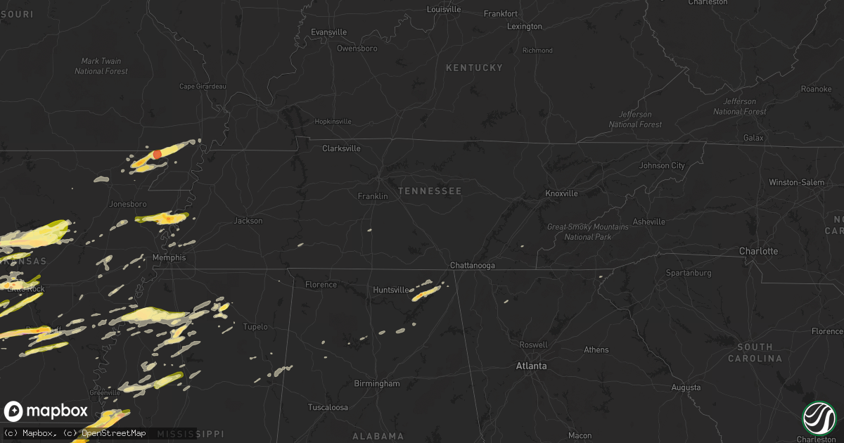
Hail Map in Tennessee on April 19, 2015
Get this storm
April 19 map
$229
one time, instant access
Download today. No call, no setup
Keep the $229
Bought the map and want the full workflow? Apply the entire $229 to a subscription within 7 days. None of it is wasted.
Every map, not just this one
This buys you this map. Subscription and you get every map we run, in the markets you choose from a few cities to whole states to nationwide. Plus real-time alerts the moment a storm fires.
Contact data
Name, contact info, occupancy, even credit band for addresses in the footprint. You go from where it hit to who to call.
Become the source they trust
Unlimited branding weather history reports on demand. You already have the documented answer ready for the property owner, and you are the one who showed up with it.
Property data and RoofTrace estimates
Pull up any address you have got, its value and the exact code rules for that jurisdiction, straight from One Click Code. Then RoofTrace estimates the squares, pitch, and roof value, priced the way you price.
Storm reports in Tennessee
Tennessee
| Date | Description |
|---|---|
| 04/19/20154:25 PM CDT | 3 trees down on riley creek rd at normandy lake. Time estimated based on radar. |
| 04/19/20153:40 PM CDT | Delayed report from sunday afternoon. Outbuilding destroyed with sheet metal blown into trees in rayon city. |
| 04/19/20153:37 PM CDT | Tree blocking pennington bend road near grace church |
| 04/19/20153:37 PM CDT | Tree blocking pennington bend road near grace church |
| 04/19/20153:33 PM CDT | Electrical wires and a few trees down in east nashville. Time estimated based on radar. |
| 04/19/20153:30 AM CDT | Numerous trees and power lines down in red bank and nearby communities. |
| 04/19/20153:26 AM CDT | Tree across maysville road south of winchester. |
| 04/19/20153:00 AM CDT | Public reported trees down on houses...power lines...and roads across grundy county |
| 04/19/20153:00 AM CDT | Tree down on house in sparta |
| 04/19/20152:49 AM CDT | Pictures of multiple trees uprooted and snapped in monteagle on the grundy county side. Time estimated based on radar. |
| 04/19/20152:40 AM CDT | Facebook report of part of tree blown into road in mcminnville. Wsmv-tv reported a 50 mph wind gust at warren county high school. |
| 04/19/20152:36 AM CDT | Trees and power lines down on highway 52 west |
| 04/19/20152:34 AM CDT | Tree down blocking york highway |
| 04/19/20152:30 AM CDT | Several trees were downed by thunderstorm winds. |
| 04/19/20152:26 AM CDT | Tree across maysville road south of winchester. |
| 04/19/20152:25 AM CDT | Several trees were downed due to thunderstorm winds. |
| 04/19/20152:24 AM CDT | Trees were uprooted at a residence. |
| 04/19/20152:15 AM CDT | A few trees down on back roads in eastern macon county |
| 04/19/20152:12 AM CDT | Thunderstorm winds knocked down trees...on cars in some cases...power lines...and produced roof damage. This damage was along lincoln lake road. |
| 04/19/20152:09 AM CDT | Thunderstorm winds knocked down trees...on cars in some cases...power lines...and produced roof damage. This damage was along oliver smith road. |
| 04/19/20152:09 AM CDT | Thunderstorm winds knocked down trees...on cars in some cases...power lines...and produced roof damage. This damage was along crystal springs road. |
| 04/19/20152:08 AM CDT | Thunderstorm winds knocked down trees..on cars in some cases...power lines...and produced roof damage. This damage was along howell hill road. |
| 04/19/20151:47 AM CDT | Thunderstorm winds knocked down trees...on cars in some cases...power lines...and produced wind damage. This was along power station road. |
| 04/19/20151:46 AM CDT | Thunderstorm winds knocked down trees...power lines...produced roof damage...and knocked down trees on cars. Along highway 110 at old baptist road. |
| 04/19/20151:35 AM CDT | Tree down partially blocking the road at highway 52 and mount vernon road |
| 04/19/20151:35 AM CDT | Trained spotter at 2161 verona camey road reported power poles snapped...trees down blocking his driveway...and debris plastered on his barn. |
| 04/19/20151:22 AM CDT | A local report indicates 60 MPH wind near 4 NE GREEN HILL |
| 04/19/20151:20 AM CDT | Tree down blocking barnes road |
| 04/19/20151:10 AM CDT | Tree down blocking driveway of house on highway 96 east near i-65 |
| 04/19/20151:05 AM CDT | Tree fell on mobile home on cheyenne blvd. No injuries. |
| 04/19/20151:00 AM CDT | Tree down |
| 04/19/201512:55 AM CDT | Trees down |
| 04/19/201512:41 AM CDT | Trees down on sams creek road at dry creek road |
| 04/19/201512:41 AM CDT | Trees down on sycamore valley road at fox hill road |
| 04/19/201512:30 AM CDT | Trees down on highway 230 |
| 04/19/201512:25 AM CDT | Trees down on highway 100 west near beaverdam road |
| 04/18/201510:00 PM CDT | A couple of downed power lines and a large limb damaged a mobile home. |
| 04/18/20159:40 PM CDT | A local report indicates 60 MPH wind near DYERSBURG |
| 04/18/20159:28 PM CDT | Trees and power lines down across greene county. |
| 04/18/20159:11 PM CDT | A few trees and power lines down in rogersville. |
| 04/18/20158:35 PM CDT | Few trees down county-wide. |
| 04/18/20158:15 PM CDT | A few trees and power lines down across union county |
| 04/18/20158:06 PM CDT | Multiple trees and a few power lines down across knox county. |
| 04/18/20157:58 PM CDT | Several trees and a few power lines down across blount county. |
| 04/18/20157:31 PM CDT | Multiple trees down across monroe county...including the vonore and madisonville areas. |
| 04/18/20157:27 PM CDT | Damage to the roof of a gas station from strong thunderstorm winds in madisonville. |
| 04/18/20157:12 PM CDT | A few trees down and tin roof blown off of a shed along joyner hollow rd. |
All States Impacted by Hail Map on April 19, 2015
Cities Impacted by Hail Map on April 19, 2015
- Burnsville, MS
- Hot Springs National Park, AR
- Pearcy, AR
- Malvern, AR
- Rayville, LA
- Pioneer, LA
- Oak Grove, LA
- Oak Ridge, LA
- Mer Rouge, LA
- Collinston, LA
- Converse, LA
- Piggott, AR
- Saint Francis, AR
- Campbell, MO
- Chappell Hill, TX
- Brenham, TX
- Washington, TX
- Heth, AR
- Cave City, AR
- Foley, AL
- Marianna, AR
- Oakland, MS
- Batesville, MS
- Enid, MS
- Courtland, MS
- Pope, MS
- Bastrop, TX
- Knobel, AR
- Pollard, AR
- Clarkton, MO
- Malden, MO
- Parma, MO
- Corning, AR
- Rector, AR
- Gideon, MO
- Weimar, TX
- Columbus, TX
- Murfreesboro, AR
- Amity, AR
- Houston, TX
- Sugar Land, TX
- Dayton, TX
- Nacogdoches, TX
- Alvin, TX
- Liverpool, TX
- Schulenburg, TX
- Brookshire, TX
- Wallis, TX
- Cat Spring, TX
- Sealy, TX
- Fulshear, TX
- Shreveport, LA
- De Berry, TX
- Marshall, TX
- Bethany, LA
- Waskom, TX
- Keithville, LA
- Ozark, AL
- La Grange, TX
- Alleyton, TX
- Garwood, TX
- Glidden, TX
- Palestine, AR
- Colt, AR
- Lexington, TX
- Crockett, TX
- Spring, TX
- Conroe, TX
- Hallettsville, TX
- Sublime, TX
- Little Rock, AR
- Wallisville, TX
- Anahuac, TX
- Wilson, AR
- Marked Tree, AR
- Dyess, AR
- Osceola, AR
- Keiser, AR
- Henning, TN
- Lepanto, AR
- Pittsburg, OK
- Kiowa, OK
- Benton, LA
- North Zulch, TX
- Iola, TX
- Timpson, TX
- Garrison, TX
- Shelbyville, TX
- Belmont, LA
- Pleasant Hill, LA
- Marthaville, LA
- Cushing, TX
- Center, TX
- Zwolle, LA
- Tenaha, TX
- Robeline, LA
- Neelyville, MO
- White Hall, AR
- Pine Bluff, AR
- Colfax, LA
- Lena, LA
- Havana, AR
- Blue Mountain, AR
- New Blaine, AR
- Magazine, AR
- Booneville, AR
- Delaware, AR
- Dardanelle, AR
- Paris, AR
- Lake Providence, LA
- Thaxton, MS
- Mabelvale, AR
- Vidalia, LA
- Woodville, MS
- Center Point, LA
- Deville, LA
- Jonesville, LA
- Effie, LA
- Marksville, LA
- Monterey, LA
- Crosby, MS
- Acme, LA
- Clayton, GA
- Dry Prong, LA
- Boyce, LA
- Pineville, LA
- Ball, LA
- Pollock, LA
- Grayson, LA
- Doddridge, AR
- Glen Allan, MS
- Mayersville, MS
- Chatham, MS
- Greenville, MS
- Anguilla, MS
- Hollandale, MS
- Rolling Fork, MS
- Pond Creek, OK
- Hackett, AR
- Wister, OK
- Mansfield, AR
- Huntington, AR
- Greenwood, AR
- Poteau, OK
- Cameron, OK
- Midland, AR
- Hartford, AR
- Lafe, AR
- Kirbyville, TX
- Conway, AR
- Wooster, AR
- Greenbrier, AR
- Mangham, LA
- Heber Springs, AR
- Lambert, MS
- Cloutierville, LA
- Provencal, LA
- Ponte Vedra Beach, FL
- Plainview, AR
- Carthage, AR
- Gary, TX
- Katy, TX
- Smithville, TX
- Charleston, MS
- Moulton, TX
- Shiner, TX
- Greenwood, MS
- Carrollton, MS
- San Augustine, TX
- Benton, AR
- Glenwood, AR
- Oxford, MS
- Mount Enterprise, TX
- Long Branch, TX
- Paragould, AR
- Marmaduke, AR
- Clarksville, AR
- Sheridan, AR
- Leola, AR
- Grapevine, AR
- Cecil, AR
- Charleston, AR
- Ozark, AR
- Earle, AR
- Widener, AR
- Mount Ida, AR
- Etta, MS
- Monroe, LA
- Columbia, LA
- Sledge, MS
- Sardis, MS
- Crenshaw, MS
- Tomball, TX
- Pinehurst, TX
- Magnolia, TX
- Cypress, TX
- Jessieville, AR
- Waller, TX
- Navasota, TX
- Hempstead, TX
- Crosby, TX
- Hattieville, AR
- Danville, AR
- Pottsville, AR
- Atkins, AR
- Abbeville, MS
- Okolona, MS
- Aberdeen, MS
- Huntsville, TX
- Bedias, TX
- Laneville, TX
- Henderson, TX
- West Point, MS
- Columbus, MS
- Burton, TX
- Ledbetter, TX
- Wardville, OK
- Atlanta, TX
- Somerville, TX
- Caldwell, TX
- Bokoshe, OK
- Shady Point, OK
- Winona, MS
- Pocahontas, AR
- Black Rock, AR
- Weiner, AR
- Harrisburg, AR
- Fisher, AR
- Dundee, MS
- Helena, AR
- Marks, MS
- Friars Point, MS
- Coahoma, MS
- Clarksdale, MS
- Waldron, AR
- Myrtle, MS
- Hankamer, TX
- Pearland, TX
- Manvel, TX
- Fresno, TX
- Rosharon, TX
- Itta Bena, MS
- Moorhead, MS
- Sunflower, MS
- Indianola, MS
- Baytown, TX
- Prescott, AR
- Wabbaseka, AR
- Scottsboro, AL
- Woodville, AL
- Pangburn, AR
- Cleveland, AR
- Clinton, AR
- Tumbling Shoals, AR
- Mount Vernon, AR
- Center Ridge, AR
- Judsonia, AR
- Rose Bud, AR
- Romance, AR
- Searcy, AR
- Enola, AR
- Springfield, AR
- Pleasant Plains, AR
- Wilburn, AR
- Belleville, AR
- Floral, AR
- Guy, AR
- Solgohachia, AR
- Damascus, AR
- Quitman, AR
- Drasco, AR
- Bee Branch, AR
- Star City, AR
- Devers, TX
- Porter, TX
- Huffman, TX
- New Caney, TX
- Winnie, TX
- Liberty, TX
- Kingwood, TX
- Humble, TX
- Millington, TN
- Drummonds, TN
- Bryan, TX
- Highlands, TX
- Bivins, TX
- Bonnerdale, AR
- Caddo Gap, AR
- Potts Camp, MS
- Hickory Flat, MS
- Pontotoc, MS
- Gould, AR
- Yorktown, AR
- Ponca, AR
- Subiaco, AR
- Scranton, AR
- Langley, AR
- Channelview, TX
- Pasadena, TX
- Galena Park, TX
- Jennings, OK
- Maramec, OK
- Madisonville, TX
- New Llano, LA
- Anacoco, LA
- Fort Polk, LA
- Leesville, LA
- Hornbeck, LA
- Plumerville, AR
- Coalgate, OK
- Stevenson, AL
- Flat Rock, AL
- Hollywood, AL
- Grant, AL
- Pisgah, AL
- Greenway, AR
- Gibson, MO
- Peach Orchard, AR
- Catron, MO
- Lilbourn, MO
- Delaplaine, AR
- Houston, AR
- Perry, AR
- Morrilton, AR
- Perryville, AR
- Mayflower, AR
- Roland, AR
- Gurdon, AR
- Okolona, AR
- Stilwell, OK
- Bunch, OK
- Forrest City, AR
- Madison, AR
- Many, LA
- Lyons, TX
- Grady, AR
- Rison, AR
- Arkadelphia, AR
- Altheimer, AR
- Stuart, OK
- Yates Center, KS
- North Little Rock, AR
- Rusk, TX
- Philipp, MS
- Minter City, MS
- Wheatley, AR
- Brinkley, AR
- Moro, AR
- Belcher, LA
- Hockley, TX
- Montgomery, TX
- Waynesboro, TN
- Olivehill, TN
- Kelly, LA
- Olla, LA
- Minden, LA
- Cotton Valley, LA
- Haughton, LA
- Mooringsport, LA
- Deer, AR
- Pettigrew, AR
- Kingston, AR
- Bradford, AR
- London, AR
- Dover, AR
- Russellville, AR
- Knoxville, AR
- Lamar, AR
- Ola, AR
- Casa, AR
- McCarley, MS
- Bismarck, AR
- Schlater, MS
- Ruleville, MS
- Holcomb, MS
- Grenada, MS
- Rosanky, TX
- Red Rock, TX
- Cedar Creek, TX
- Montgomery, LA
- Memphis, TN
- Houston, MS
- Elaine, AR
- Washington, AR
- Arlington, TN
- Gonzales, TX
- Longton, KS
- Elk Falls, KS
- Tatum, TX
- Palm Coast, FL
- Saint Augustine, FL
- Crane Hill, AL
- Vian, OK
- Stigler, OK
- Holcomb, MO
- Maumelle, AR
- Spivey, KS
- Kingman, KS
- Midway, TX
- Carbon Hill, AL
- Eldridge, AL
- Jesup, GA
- Vilonia, AR
- Natchez, LA
- Melrose, LA
- Natchitoches, LA
- Dime Box, TX
- Paron, AR
- Blevins, AR
- Richmond, TX
- Hamshire, TX
- Cullman, AL
- Santa Rosa Beach, FL
- Amory, MS
- Stuttgart, AR
- De Witt, AR
- Brunswick, GA
- Hortense, GA
- Arley, AL
- Parthenon, AR
- Winnfield, LA
- Tullos, LA
- Spurger, TX
- Imboden, AR
- Walnut Ridge, AR
- Gilliam, LA
- Scott, AR
- Sparkman, AR
- New Ulm, TX
- Atlanta, LA
- Flatwoods, LA
- Mora, LA
- Florien, LA
- Fisher, LA
- Trenton, AL
- Water Valley, MS
- Crumrod, AR
- Culleoka, TN
- Kingsland, AR
- Hensley, AR
- Trumann, AR
- Gillett, AR
- Almyra, AR
- Harper, KS
- Vivian, LA
- Winnsboro, LA
- Baskin, LA
- Joaquin, TX
- East Bernard, TX
- Logan, AL
- Letona, AR
- Augusta, AR
- Alligator, MS
- Snow Lake, AR
- Mellwood, AR
- Carmine, TX
- Giddings, TX
- West Helena, AR
- Traskwood, AR
- Poyen, AR
- Bauxite, AR
- England, AR
- Frenchmans Bayou, AR
- Bassett, AR
- Joiner, AR
- Abbeville, AL
- Epps, LA
- Delhi, LA
- Lovelady, TX
- Beckville, TX
- Summers, AR
- Westville, OK
- Lonsdale, AR
- Birmingham, AL
- Ratcliff, AR
- Lamont, OK
- Deer Creek, OK
- Resaca, GA
- Ranger, GA
- Palatka, FL
- Florahome, FL
- Snow, OK
- Rattan, OK
- Scobey, MS
- Cascilla, MS
- Tillatoba, MS
- Coffeeville, MS
- Belzoni, MS
- Bastrop, LA
- West Point, TX
- Lexa, AR
- Winfield, KS
- Caledonia, MS
- Sulligent, AL
- Steens, MS
- Vernon, AL
- Bryant, AR
- Albertville, AL
- Duck Hill, MS
- Starkville, MS
- Roe, AR
- Ponte Vedra, FL
- Riceboro, GA
- Royal, AR
- Mountain Pine, AR
- Tonkawa, OK
- Alexander, AR
- Etowah, TN
- Burkeville, TX
- Paint Rock, AL
- Stringtown, OK
- Watson, AR
- Saint Charles, AR
- Ethel, AR
- Covington, TN
- Skipperville, AL
- Newville, AL
- Oil Trough, AR
- Waterford, MS
- Marvell, AR
- Poplar Grove, AR
- Silver Springs, FL
- Randolph, MS
- Cushing, OK
- Stroud, OK
- Tryon, OK
- Hagarville, AR
- Wiergate, TX
- Yale, OK
- Kennard, TX
- Apple Springs, TX
- Fackler, AL
- Sidon, MS
- Leland, MS
- Isola, MS
- Inverness, MS
- Powhatan, AR
- Smithville, AR
- Bigelow, AR
- Hot Springs Village, AR
- Trinity, TX
- Dodson, LA
- Groveton, TX
- Camden, AR
- Ludowici, GA
- Rosston, AR
- Satellite Beach, FL
- Indialantic, FL
- Merritt Island, FL
- Ecru, MS
- Bald Knob, AR
- Jerusalem, AR
- Taylor, AR
- Kyle, TX
- Dale, TX
- Lockhart, TX
- Blountsville, AL
- Horton, AL
- Guntersville, AL
- Beedeville, AR
- McCrory, AR
- Kirby, AR
- Lavaca, AR
- Aubrey, AR
- Ripley, OK
- Alexandria, LA
- Cotton Plant, AR
- Goodwin, AR
- Wynne, AR
- Glennville, GA
- Checotah, OK
- Stafford, TX
- Missouri City, TX
- Jasper, TX
- Adona, AR
- Fayetteville, TX
- Lynn, AL
- Fort Smith, AR
- New Madrid, MO
- Sikes, LA
- West Monroe, LA
- Beaumont, TX
- Douglass, TX
- Como, MS
- Lyon, MS
- Tutwiler, MS
- Concord, AR
- Flatonia, TX
- Muldoon, TX
- Jena, LA
- Sherwood, AR
- Jacksonville, AR
- Little Rock Air Force Base, AR


