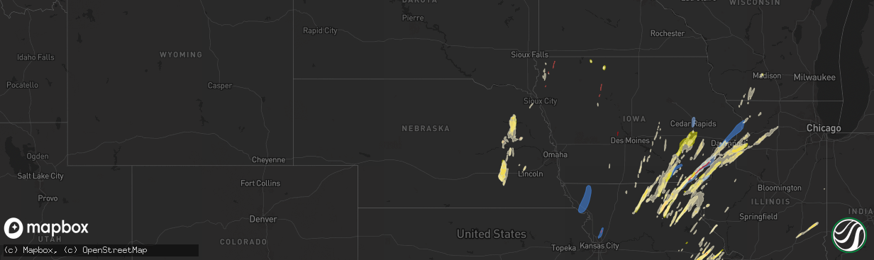
Hail Map in Nebraska on April 16, 2024
The weather event in Nebraska on April 16, 2024 includes Hail, Wind, and Tornado maps. 10 states and 581 cities were impacted and suffered possible damage. The total estimated number of properties impacted is 6,985.
Want more than just the map?
Turn this storm into a full workflow.
- Owner + property data so you know who to knock
- OnDemand branded weather history reports to win the "did we even have hail?" argument
- RoofTrace estimate so reps stop guessing numbers at the door
Bought this map? Upgrade within 7 days and we'll credit the $230. (10-15 min setup call)
Hail
Wind
Tornado
6,985
Estimated number of impacted properties by a 1.00" hail or larger0
Estimated number of impacted properties by a 1.75" hail or larger0
Estimated number of impacted properties by a 2.50" hail or largerStorm reports in Nebraska
Nebraska
| Date | Description |
|---|---|
| 04/16/20242:56 PM CDT | Photo on social media of large tree limb down across coach road south of cedardale road. Time estimated from radar. |
| 04/16/20241:49 PM CDT | Spotter video via social media. |
| 04/16/20241:39 PM CDT | Spotter video via social media. |
| 04/16/20241:39 PM CDT | Ef-0 tornado. Detailed reports from a combination of emergency management... Eyewitnesses... And video evidence from storm spotters indicates this as the path of the to |
| 04/16/20241:18 PM CDT | Eyewitness reports and photo and video evidence show that the long-lived funnel cloud formed a ground circulation that began at approximately 118 local time and lasted |
| 04/16/202412:48 PM CDT | Time estimated. Detached garage damaged at this location. |
| 04/16/202412:37 PM CDT | Ef-0 tornado. A tornado began just west of 190th avenue and about a half mile north of 445th street where it flipped a cattle shed. The tornado then tracked toward the |
| 04/16/202411:39 AM CDT | Emergency manager reporting that the tornado is roping out and touching back down. |
| 04/16/202411:35 AM CDT | Ef-0 tornado. This tornado track is based entirely off of eyewitness reports as there was no damage indicated along the entirety of the intermittent track. Emergency ma |
| 04/16/202411:34 AM CDT | Emergency manager reported a tornado 3 mi sw of platte center. |
| 04/16/20249:03 AM CDT | Part of a small garage roof removed. Damage to a power pole. Nearby trees remain standing. Time estimated based on radar. |
| 04/16/20247:20 AM CDT | Hail on the northeast side of york. Time est from radar. |
| 04/16/20247:10 AM CDT | Report with photo via social media. |
All States Impacted by Hail Map on April 16, 2024
Cities Impacted by Hail Map on April 16, 2024
- Fairmont, NE
- McCool Junction, NE
- York, NE
- Benedict, NE
- Waco, NE
- Stromsburg, NE
- Gresham, NE
- Geneva, NE
- Exeter, NE
- Andalusia, AL
- Red Level, AL
- Shelby, NE
- Greenville, AL
- Rising City, NE
- Columbus, NE
- Bellwood, NE
- Humphrey, NE
- Creston, NE
- Leigh, NE
- Stanton, NE
- Madison, NE
- Hoskins, NE
- Winside, NE
- David City, NE
- Norfolk, NE
- Oregon, MO
- Forest City, MO
- Mound City, MO
- Maitland, MO
- Fillmore, MO
- Highland, KS
- Skidmore, MO
- Graham, MO
- Maryville, MO
- Barnard, MO
- Bolckow, MO
- Burlington Junction, MO
- Clearmont, MO
- Pickering, MO
- Hopkins, MO
- Afton, IA
- Shannon City, IA
- Clarkson, NE
- Kansas City, MO
- Smithville, MO
- Mercer, MO
- Trimble, MO
- Plattsburg, MO
- Kearney, MO
- Corydon, IA
- Chariton, IA
- Millerton, IA
- Princeton, MO
- Platte Center, NE
- Dallas Center, IA
- Minburn, IA
- Bouton, IA
- Ethel, MO
- Elmer, MO
- Atlanta, MO
- La Plata, MO
- Kirksville, MO
- Schuyler, NE
- Lineville, IA
- Allerton, IA
- Russell, IA
- New Cambria, MO
- Williamson, IA
- Monroe, NE
- Green Castle, MO
- Novinger, MO
- Bevier, MO
- Columbia, IA
- Macon, MO
- Lovilia, IA
- Melrose, IA
- Gibbs, MO
- Worthington, MO
- Greentop, MO
- Glenwood, MO
- Unionville, MO
- Queen City, MO
- Coatsville, MO
- Pella, IA
- Knoxville, IA
- Brashear, MO
- Bloomfield, IA
- Livonia, MO
- Baring, MO
- Memphis, MO
- Lancaster, MO
- Hamilton, IA
- Bussey, IA
- Cairo, MO
- Jacksonville, MO
- Moulton, IA
- Clarence, MO
- Anabel, MO
- Drakesville, IA
- Hurdland, MO
- Excello, MO
- Callao, MO
- Sully, IA
- Edina, MO
- Reasnor, IA
- Downing, MO
- Floris, IA
- Ottumwa, IA
- Grinnell, IA
- Leonard, MO
- Lynnville, IA
- Kellogg, IA
- Novelty, MO
- Rutledge, MO
- Gilman, IA
- Montour, IA
- Arbela, MO
- New Sharon, IA
- Rose Hill, IA
- Montezuma, IA
- Barnes City, IA
- Lentner, MO
- Shelbina, MO
- Shelbyville, MO
- Bethel, MO
- La Belle, MO
- Chula, MO
- Laredo, MO
- Humphreys, MO
- Auxvasse, MO
- Columbia, MO
- Searsboro, IA
- Newark, MO
- Lewistown, MO
- Ewing, MO
- Galt, MO
- Milan, MO
- Philadelphia, MO
- Palmyra, MO
- Stoutsville, MO
- Perry, MO
- Middletown, MO
- Kingdom City, MO
- Wellsville, MO
- Madison, MO
- Morrison, MO
- Chamois, MO
- Emerson, NE
- Waterbury, NE
- Milton, IA
- Keosauqua, IA
- Cantril, IA
- Taylor, MO
- Newtown, MO
- Pollock, MO
- Maywood, MO
- La Grange, MO
- Linn, MO
- Hannibal, MO
- Monroe City, MO
- Center, MO
- Monticello, MO
- Canton, MO
- Vandalia, MO
- Curryville, MO
- Bowling Green, MO
- Seward, NE
- Bee, NE
- Williamstown, MO
- Williamsburg, MO
- Portland, MO
- Harris, MO
- Saint Patrick, MO
- Alexandria, MO
- Pleasant Dale, NE
- Garland, NE
- Hermann, MO
- Quincy, IL
- Ursa, IL
- Warsaw, IL
- Rhineland, MO
- Louisiana, MO
- New Florence, MO
- Malcolm, NE
- Raymond, NE
- Hurricane, WV
- Montgomery City, MO
- Jackson, NE
- Hubbard, NE
- Sod, WV
- Griffithsville, WV
- Sumerco, WV
- Yawkey, WV
- Chillicothe, MO
- Sutter, IL
- Howells, NE
- High Hill, MO
- Jonesburg, MO
- Warrenton, MO
- Truxton, MO
- Mexico, MO
- Le Mars, IA
- Hawk Point, MO
- Pittsfield, IL
- Rockport, IL
- Payson, IL
- Silex, MO
- Bellflower, MO
- Alkol, WV
- Orgas, WV
- Seth, WV
- Dodge, NE
- Drury, MO
- Vanzant, MO
- Cabool, MO
- Elk Creek, MO
- Solo, MO
- Houston, MO
- Yolyn, WV
- Quinwood, WV
- Troy, MO
- Green City, MO
- Tornado, WV
- Saint Albans, WV
- Wright City, MO
- Truesdale, MO
- Marthasville, MO
- Bland, MO
- Berger, MO
- Sioux Center, IA
- Maurice, IA
- Ireton, IA
- Hewett, WV
- Clothier, WV
- Jeffrey, WV
- Hull, IA
- Charleston, WV
- Rock Valley, IA
- Hawarden, IA
- Kenna, WV
- Jessieville, AR
- Exline, IA
- Centerville, IA
- Cincinnati, IA
- Smithers, WV
- Versailles, IL
- Rushville, IL
- Mount Sterling, IL
- Yukon, MO
- Eunice, MO
- Rockwell City, IA
- Williamsburg, WV
- Lewisburg, WV
- Crawley, WV
- Hattieville, AR
- Morrilton, AR
- Solgohachia, AR
- Moscow Mills, MO
- Udell, IA
- Unionville, IA
- Perryville, AR
- Paron, AR
- Eskdale, WV
- Foristell, MO
- Cedar Rapids, IA
- Marion, IA
- Hiawatha, IA
- Robins, IA
- Wentzville, MO
- Roland, AR
- Old Monroe, MO
- Mayflower, AR
- Winfield, MO
- Palmer, IA
- Poca, WV
- Springfield, AR
- South Charleston, WV
- Sullivan, MO
- Bourbon, MO
- Cleveland, AR
- Center Ridge, AR
- Avon, IL
- Bigelow, AR
- Maxwelton, WV
- Eldon, IA
- Rock Rapids, IA
- Doon, IA
- Agency, IA
- Leasburg, MO
- Steelville, MO
- Elkview, WV
- Washington, MO
- Hedrick, IA
- Boyden, IA
- George, IA
- Little Rock, IA
- Harrisburg, SD
- Emery, SD
- Chancellor, SD
- Freeman, SD
- Dallas, SD
- Armour, SD
- Canton, SD
- Gregory, SD
- Harrison, SD
- Parkston, SD
- Alvord, IA
- Delmont, SD
- Parker, SD
- Corsica, SD
- Inwood, IA
- Lennox, SD
- Platte, SD
- Marion, SD
- Olivet, SD
- Larchwood, IA
- Winner, SD
- Worthing, SD
- Burke, SD
- Maumelle, AR
- North Little Rock, AR
- Conway, AR
- Sherwood, AR
- Jacksonville, AR
- Vilonia, AR
- Lake Saint Louis, MO
- O'Fallon, MO
- Batavia, IA
- Selma, IA
- Potosi, MO
- Martinsburg, IA
- Sigourney, IA
- Libertyville, IA
- Fairfield, IA
- Gilmore City, IA
- Rolfe, IA
- Fletcher, MO
- Blackwell, MO
- Richwoods, MO
- De Soto, MO
- Ollie, IA
- Packwood, IA
- Richland, IA
- Cabot, AR
- Austin, AR
- Beebe, AR
- Hillsboro, MO
- Dittmer, MO
- El Paso, AR
- Quitman, AR
- Harper, IA
- South English, IA
- Keota, IA
- North English, IA
- Parnell, IA
- Wellman, IA
- Williamsburg, IA
- Kalona, IA
- Oxford, IA
- Kensett, AR
- Searcy, AR
- Higginson, AR
- Riverside, IA
- Iowa City, IA
- McRae, AR
- Garner, AR
- West Chester, IA
- Washington, IA
- Mount Sterling, IA
- Tiffin, IA
- North Liberty, IA
- Coralville, IA
- Luray, MO
- Bonaparte, IA
- Solon, IA
- Pangburn, AR
- Wilburn, AR
- Heber Springs, AR
- Kahoka, MO
- Farmington, IA
- Wayland, IA
- Brighton, IA
- West Point, IA
- Donnellson, IA
- Hillsboro, IA
- Salem, IA
- Swisher, IA
- Carthage, AR
- Sparkman, AR
- Bradford, AR
- Mount Pleasant, IA
- New London, IA
- Wyaconda, MO
- Wayland, MO
- Ainsworth, IA
- Crawfordsville, IA
- Sheridan, AR
- Newport, AR
- Leola, AR
- Marquand, MO
- Owensville, MO
- Steedman, MO
- Mokane, MO
- Mount Union, IA
- Yarmouth, IA
- Argyle, IA
- Mediapolis, IA
- Morning Sun, IA
- Scott, AR
- Amagon, AR
- Fisher, AR
- Grapevine, AR
- Columbus Junction, IA
- Lone Tree, IA
- Conesville, IA
- Nichols, IA
- McNeil, AR
- Magnolia, AR
- Waldo, AR
- Little Rock, AR
- Revere, MO
- Weiner, AR
- Wapello, IA
- Montrose, IA
- Fenton, IA
- Ringsted, IA
- Gorin, MO
- Fort Madison, IA
- Pine Bluff, AR
- Elizabeth, IL
- Stephens, AR
- West Branch, IA
- West Liberty, IA
- Oakville, IA
- New Boston, IL
- Apple River, IL
- Scales Mound, IL
- Shullsburg, WI
- Louann, AR
- Wever, IA
- Denmark, IA
- Danville, IA
- Burlington, IA
- West Burlington, IA
- Middletown, IA
- Hampton, AR
- Camden, AR
- Gratiot, WI
- Darlington, WI
- Illinois City, IL
- Sperry, IA
- Estherville, IA
- Muscatine, IA
- Blue Grass, IA
- Montpelier, IA
- Joy, IL
- Stockton, IL
- Argyle, WI
- South Wayne, WI
- Warren, IL
- Seaton, IL
- Keithsburg, IL
- Harrell, AR
- Taylor Ridge, IL
- Reynolds, IL
- Davenport, IA
- Walcott, IA
- Nora, IL
- Andalusia, IL
- Buffalo, IA
- Oquawka, IL
- Eldridge, IA
- Long Grove, IA
- De Witt, IA
- Camanche, IA
- Princeton, IA
- McCausland, IA
- Woodford, WI
- Aledo, IL
- Milan, IL
- Blanchardville, WI
- Browntown, WI
- Monticello, WI
- Sherrard, IL
- Matherville, IL
- Neoga, IL
- Viola, IL
- Trilla, IL
- Lerna, IL
- Orion, IL
- Lynn Center, IL
- Keokuk, IA
- Coal Valley, IL
- New Windsor, IL
- Nauvoo, IL
- Ashmore, IL
- Charleston, IL
- Geneseo, IL
- Colona, IL
- Kansas, IL
- Bryant, IA
- Clinton, IA
- Goose Lake, IA
- Low Moor, IA
- Cordova, IL
- Fulton, IL
- Thomson, IL
- Sabula, IA
- Savanna, IL
- Mount Carroll, IL
- Hillsdale, IL
- West Point, IL
- Mendon, IL
- Paris, IL
- Grady, AR
- Coatsburg, IL
- Loraine, IL
- Niota, IL
- Little York, IL
- Paloma, IL
- Erie, IL
- Hoopeston, IL
- Gould, AR
- Alexis, IL
- Lanark, IL
- Fowler, IL
- Stuttgart, AR
- Monmouth, IL
- Redmon, IL
- Brocton, IL
- Osco, IL
- Cambridge, IL
- Fenton, IL
- North Henderson, IL
- Atkinson, IL
- Moline, IL
- Morrison, IL
- Alpha, IL
- Prophetstown, IL
- Le Claire, IA
- Forreston, IL
- Ophiem, IL
- Woodhull, IL
- Rio, IL
- Andover, IL
- Lyndon, IL
- Shannon, IL
- Madison, WI
- Middleton, WI
- Baileyville, IL
- Freeport, IL
- Verona, WI
- Gerlaw, IL
- Annawan, IL
- Mineral, IL
- Albion, IL
- Bone Gap, IL
- West Salem, IL
- Tampico, IL
- Sheffield, IL
- New Bedford, IL
- Walnut, IL
- Deer Grove, IL
- Harmon, IL
- Amboy, IL
- Ohio, IL
- Dixon, IL
- Ashton, IL
- Franklin Grove, IL
- West Brooklyn, IL
- Steward, IL
- Rochelle, IL
- Victor, WV
- Lansing, WV
- Stockton, IA
- Virgil, KS
- Rowley, IA
- Independence, IA
- Winthrop, IA
- Corning, IA
- Anita, IA


