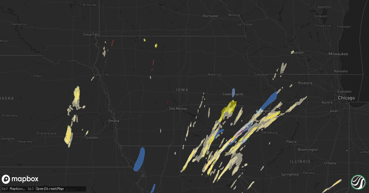
Hail Map in Iowa on April 16, 2024
Get this storm
April 16 map
$229
one time, instant access
Download today. No call, no setup
Keep the $229
Bought the map and want the full workflow? Apply the entire $229 to a subscription within 7 days. None of it is wasted.
Every map, not just this one
This buys you this map. Subscription and you get every map we run, in the markets you choose from a few cities to whole states to nationwide. Plus real-time alerts the moment a storm fires.
Contact data
Name, contact info, occupancy, even credit band for addresses in the footprint. You go from where it hit to who to call.
Become the source they trust
Unlimited branding weather history reports on demand. You already have the documented answer ready for the property owner, and you are the one who showed up with it.
Property data and RoofTrace estimates
Pull up any address you have got, its value and the exact code rules for that jurisdiction, straight from One Click Code. Then RoofTrace estimates the squares, pitch, and roof value, priced the way you price.
Storm reports in Iowa
Iowa
| Date | Description |
|---|---|
| 04/16/20246:55 PM CDT | Spotter reported 50 to 60 mph winds with at least some 5 inch branches down. |
| 04/16/20246:48 PM CDT | Relayed a report of trees down blocking highway 30 and 30th street west of mill creek parkway on the west side clinton. Time of the event was estimate using radar. |
| 04/16/20246:20 PM CDT | Corrects previous hail report from 2 ese davenport. Dime to quarters near vanderveer park... Delayed report. |
| 04/16/20246:20 PM CDT | 8 inch diameter red cedar tree snapped. |
| 04/16/20246:18 PM CDT | Dvn asos. |
| 04/16/20245:49 PM CDT | A local report indicates 1.00 inch wind near West Burlington |
| 04/16/20245:49 PM CDT | A local report indicates 1.00 inch wind near 1 WNW Estherville |
| 04/16/20245:47 PM CDT | Photo from spotter. Time estimated. |
| 04/16/20245:27 PM CDT | Two trees uprooted and several smaller trees snapped. |
| 04/16/20245:20 PM CDT | Dime to quarters near vanderveer park... Delayed report. |
| 04/16/20245:18 PM CDT | Report from mping: quarter |
| 04/16/20245:14 PM CDT | Tree branches down. |
| 04/16/20245:05 PM CDT | Delayed report. Farm hoop building destroyed. Time estimated based on radar. |
| 04/16/20245:04 PM CDT | Report from mping: trees uprooted or snapped; roof blown off. |
| 04/16/20245:02 PM CDT | Trees down in town... Delayed report. |
| 04/16/20244:49 PM CDT | A local report indicates 72 MPH wind near Stanwood |
| 04/16/20244:46 PM CDT | Report from mping: 3-inch tree limbs broken; power poles broken. |
| 04/16/20244:45 PM CDT | 60 mph gusts estimated fence blown down tree lost limbs. |
| 04/16/20244:40 PM CDT | Ia dot rwis. |
| 04/16/20244:34 PM CDT | Corrects previous tornado report from 4 e salem. A storm spotter was following storm and came across major house damage near jewell ave/salem rd or east of 218 on salem |
| 04/16/20244:27 PM CDT | Report from mping: 1-inch tree limbs broken; shingles blown off. |
| 04/16/20244:24 PM CDT | Em reporting multiple multiple power lines down on riverside drive in iowa city. |
| 04/16/20244:20 PM CDT | Corrects previous tstm wnd dmg report from 1 w iowa city municipality. Two trees uprooted and several smaller trees snapped. |
| 04/16/20244:11 PM CDT | Tree branches down. |
| 04/16/20244:10 PM CDT | Straight line winds estimated at least 60 mph. Also reported half inch hail. |
| 04/16/20244:09 PM CDT | A local report indicates 1.00 inch wind near 1 E Tiffin |
| 04/16/20244:09 PM CDT | Report from mping: quarter |
| 04/16/20244:03 PM CDT | Report from mping: quarter |
| 04/16/20244:03 PM CDT | A local report indicates 1.00 inch wind near Mount Sterling |
| 04/16/20244:00 PM CDT | A lot of smaller hail. |
| 04/16/20244:00 PM CDT | Old barn along us 52 lost roof and some sides. Time estimated from radar. |
| 04/16/20243:57 PM CDT | Corrects previous hail report from 1 sw kalona. Report from mping: quarter |
| 04/16/20243:44 PM CDT | Occurring right now and lots of it. Also estimate winds 50+ mph with a tree down. |
| 04/16/20243:36 PM CDT | Officer located near the intersection of highways 3 and 15 looking to the northeast and viewing a tornado. |
| 04/16/20243:27 PM CDT | Semi jackknifed in the median of highway 151 at mile marker 48 on the linn/jones county. Time estimated using radar. |
| 04/16/20243:18 PM CDT | A local report indicates 58 MPH wind near Eldon |
| 04/16/20243:14 PM CDT | Spotter as well as law enforcement have confirmed a small rope tornado east of palmer. |
| 04/16/20243:08 PM CDT | Semi blown over at milemarker 261. Highway blocked. Time of the event estimated using radar. |
| 04/16/20243:02 PM CDT | An ef-1 tornado touched down northwest of quasqueton... Ia near the pine creek wildlife area... Damaging several trees along 262nd st. The tornado continued to track to |
| 04/16/20243:01 PM CDT | Damage to outbuilding. Time estimated via radar. |
| 04/16/20242:59 PM CDT | Brief tornado touchdown based on storm survey. |
| 04/16/20242:59 PM CDT | A local report indicates a tornado near 2 S Manson |
| 04/16/20242:59 PM CDT | A couple buildings had their ro |
| 04/16/20242:59 PM CDT | A couple buildings had their roofs blown off. |
| 04/16/20242:56 PM CDT | Report from mping: 1-inch tree limbs broken; shingles blown off. |
| 04/16/20242:56 PM CDT | Report from mping: quarter |
| 04/16/20242:53 PM CDT | Along with torrential rain and pea size hail. |
| 04/16/20242:53 PM CDT | Also some hail but size unknown. |
| 04/16/20242:45 PM CDT | A local report indicates 60 MPH wind near Atkins |
| 04/16/20242:35 PM CDT | A local report indicates a tornado near 5 WSW Knierim |
| 04/16/20242:29 PM CDT | Brief tornado lasting approximately 1 min. Tin displayed from roof of outbuilding. |
| 04/16/20242:21 PM CDT | Two grain bins destroyed by nearby thunderstorm outflow. |
| 04/16/20242:11 PM CDT | Location estimated as viewed by emergency manager. |
| 04/16/20242:10 PM CDT | Photo via social media of trailer blown into ditch and destroyed on hwy 75 about 0.5 mile south of merrill. Time estimated via radar. |
| 04/16/20241:59 PM CDT | Confirmed tornado by emergency manager. |
| 04/16/20241:50 PM CDT | Via mping. Social media confirms quarter si |
| 04/16/20241:50 PM CDT | Via mping. Social media confirms quarter size hail in northern sioux city. Time estimated via radar. |
| 04/16/20241:49 PM CDT | Horse lean-to destroyed and horse injured. Broken tree branches. |
| 04/16/20241:46 PM CDT | Brief touchdown in open field reported by hinton police department. |
| 04/16/202412:35 PM CDT | Livestock building sustained damage during structural repair. Time estimated by radar. |
| 04/16/202412:08 PM CDT | Delayed report. Time estimated from radar. Reported at post office. |
| 04/16/202411:10 AM CDT | Outbuilding sheet metal scattered in fields. |
| 04/16/202411:05 AM CDT | Damage to outbuilding. Time estimated from radar. |
| 04/15/20247:09 PM CDT | Asos station kbrl burlington arpt. |
All States Impacted by Hail Map on April 16, 2024
Cities Impacted by Hail Map on April 16, 2024
- Fairmont, NE
- McCool Junction, NE
- York, NE
- Benedict, NE
- Waco, NE
- Stromsburg, NE
- Gresham, NE
- Geneva, NE
- Exeter, NE
- Andalusia, AL
- Red Level, AL
- Shelby, NE
- Greenville, AL
- Rising City, NE
- Columbus, NE
- Bellwood, NE
- Humphrey, NE
- Creston, NE
- Leigh, NE
- Stanton, NE
- Madison, NE
- Hoskins, NE
- Winside, NE
- David City, NE
- Norfolk, NE
- Oregon, MO
- Forest City, MO
- Mound City, MO
- Maitland, MO
- Fillmore, MO
- Highland, KS
- Skidmore, MO
- Graham, MO
- Maryville, MO
- Barnard, MO
- Bolckow, MO
- Burlington Junction, MO
- Clearmont, MO
- Pickering, MO
- Hopkins, MO
- Afton, IA
- Shannon City, IA
- Clarkson, NE
- Kansas City, MO
- Smithville, MO
- Mercer, MO
- Trimble, MO
- Plattsburg, MO
- Kearney, MO
- Corydon, IA
- Chariton, IA
- Millerton, IA
- Princeton, MO
- Platte Center, NE
- Dallas Center, IA
- Minburn, IA
- Bouton, IA
- Ethel, MO
- Elmer, MO
- Atlanta, MO
- La Plata, MO
- Kirksville, MO
- Schuyler, NE
- Lineville, IA
- Allerton, IA
- Russell, IA
- New Cambria, MO
- Williamson, IA
- Monroe, NE
- Green Castle, MO
- Novinger, MO
- Bevier, MO
- Columbia, IA
- Macon, MO
- Lovilia, IA
- Melrose, IA
- Gibbs, MO
- Worthington, MO
- Greentop, MO
- Glenwood, MO
- Unionville, MO
- Queen City, MO
- Coatsville, MO
- Pella, IA
- Knoxville, IA
- Brashear, MO
- Bloomfield, IA
- Livonia, MO
- Baring, MO
- Memphis, MO
- Lancaster, MO
- Hamilton, IA
- Bussey, IA
- Cairo, MO
- Jacksonville, MO
- Moulton, IA
- Clarence, MO
- Anabel, MO
- Drakesville, IA
- Hurdland, MO
- Excello, MO
- Callao, MO
- Sully, IA
- Edina, MO
- Reasnor, IA
- Downing, MO
- Floris, IA
- Ottumwa, IA
- Grinnell, IA
- Leonard, MO
- Lynnville, IA
- Kellogg, IA
- Novelty, MO
- Rutledge, MO
- Gilman, IA
- Montour, IA
- Arbela, MO
- New Sharon, IA
- Rose Hill, IA
- Montezuma, IA
- Barnes City, IA
- Lentner, MO
- Shelbina, MO
- Shelbyville, MO
- Bethel, MO
- La Belle, MO
- Chula, MO
- Laredo, MO
- Humphreys, MO
- Auxvasse, MO
- Columbia, MO
- Searsboro, IA
- Newark, MO
- Lewistown, MO
- Ewing, MO
- Galt, MO
- Milan, MO
- Philadelphia, MO
- Palmyra, MO
- Stoutsville, MO
- Perry, MO
- Middletown, MO
- Kingdom City, MO
- Wellsville, MO
- Madison, MO
- Morrison, MO
- Chamois, MO
- Emerson, NE
- Waterbury, NE
- Milton, IA
- Keosauqua, IA
- Cantril, IA
- Taylor, MO
- Newtown, MO
- Pollock, MO
- Maywood, MO
- La Grange, MO
- Linn, MO
- Hannibal, MO
- Monroe City, MO
- Center, MO
- Monticello, MO
- Canton, MO
- Vandalia, MO
- Curryville, MO
- Bowling Green, MO
- Seward, NE
- Bee, NE
- Williamstown, MO
- Williamsburg, MO
- Portland, MO
- Harris, MO
- Saint Patrick, MO
- Alexandria, MO
- Pleasant Dale, NE
- Garland, NE
- Hermann, MO
- Quincy, IL
- Ursa, IL
- Warsaw, IL
- Rhineland, MO
- Louisiana, MO
- New Florence, MO
- Malcolm, NE
- Raymond, NE
- Hurricane, WV
- Montgomery City, MO
- Jackson, NE
- Hubbard, NE
- Sod, WV
- Griffithsville, WV
- Sumerco, WV
- Yawkey, WV
- Chillicothe, MO
- Sutter, IL
- Howells, NE
- High Hill, MO
- Jonesburg, MO
- Warrenton, MO
- Truxton, MO
- Mexico, MO
- Le Mars, IA
- Hawk Point, MO
- Pittsfield, IL
- Rockport, IL
- Payson, IL
- Silex, MO
- Bellflower, MO
- Alkol, WV
- Orgas, WV
- Seth, WV
- Dodge, NE
- Drury, MO
- Vanzant, MO
- Cabool, MO
- Elk Creek, MO
- Solo, MO
- Houston, MO
- Yolyn, WV
- Quinwood, WV
- Troy, MO
- Green City, MO
- Tornado, WV
- Saint Albans, WV
- Wright City, MO
- Truesdale, MO
- Marthasville, MO
- Bland, MO
- Berger, MO
- Sioux Center, IA
- Maurice, IA
- Ireton, IA
- Hewett, WV
- Clothier, WV
- Jeffrey, WV
- Hull, IA
- Charleston, WV
- Rock Valley, IA
- Hawarden, IA
- Kenna, WV
- Jessieville, AR
- Exline, IA
- Centerville, IA
- Cincinnati, IA
- Smithers, WV
- Versailles, IL
- Rushville, IL
- Mount Sterling, IL
- Yukon, MO
- Eunice, MO
- Rockwell City, IA
- Williamsburg, WV
- Lewisburg, WV
- Crawley, WV
- Hattieville, AR
- Morrilton, AR
- Solgohachia, AR
- Moscow Mills, MO
- Udell, IA
- Unionville, IA
- Perryville, AR
- Paron, AR
- Eskdale, WV
- Foristell, MO
- Cedar Rapids, IA
- Marion, IA
- Hiawatha, IA
- Robins, IA
- Wentzville, MO
- Roland, AR
- Old Monroe, MO
- Mayflower, AR
- Winfield, MO
- Palmer, IA
- Poca, WV
- Springfield, AR
- South Charleston, WV
- Sullivan, MO
- Bourbon, MO
- Cleveland, AR
- Center Ridge, AR
- Avon, IL
- Bigelow, AR
- Maxwelton, WV
- Eldon, IA
- Rock Rapids, IA
- Doon, IA
- Agency, IA
- Leasburg, MO
- Steelville, MO
- Elkview, WV
- Washington, MO
- Hedrick, IA
- Boyden, IA
- George, IA
- Little Rock, IA
- Harrisburg, SD
- Emery, SD
- Chancellor, SD
- Freeman, SD
- Dallas, SD
- Armour, SD
- Canton, SD
- Gregory, SD
- Harrison, SD
- Parkston, SD
- Alvord, IA
- Delmont, SD
- Parker, SD
- Corsica, SD
- Inwood, IA
- Lennox, SD
- Platte, SD
- Marion, SD
- Olivet, SD
- Larchwood, IA
- Winner, SD
- Worthing, SD
- Burke, SD
- Maumelle, AR
- North Little Rock, AR
- Conway, AR
- Sherwood, AR
- Jacksonville, AR
- Vilonia, AR
- Lake Saint Louis, MO
- O'Fallon, MO
- Batavia, IA
- Selma, IA
- Potosi, MO
- Martinsburg, IA
- Sigourney, IA
- Libertyville, IA
- Fairfield, IA
- Gilmore City, IA
- Rolfe, IA
- Fletcher, MO
- Blackwell, MO
- Richwoods, MO
- De Soto, MO
- Ollie, IA
- Packwood, IA
- Richland, IA
- Cabot, AR
- Austin, AR
- Beebe, AR
- Hillsboro, MO
- Dittmer, MO
- El Paso, AR
- Quitman, AR
- Harper, IA
- South English, IA
- Keota, IA
- North English, IA
- Parnell, IA
- Wellman, IA
- Williamsburg, IA
- Kalona, IA
- Oxford, IA
- Kensett, AR
- Searcy, AR
- Higginson, AR
- Riverside, IA
- Iowa City, IA
- McRae, AR
- Garner, AR
- West Chester, IA
- Washington, IA
- Mount Sterling, IA
- Tiffin, IA
- North Liberty, IA
- Coralville, IA
- Luray, MO
- Bonaparte, IA
- Solon, IA
- Pangburn, AR
- Wilburn, AR
- Heber Springs, AR
- Kahoka, MO
- Farmington, IA
- Wayland, IA
- Brighton, IA
- West Point, IA
- Donnellson, IA
- Hillsboro, IA
- Salem, IA
- Swisher, IA
- Carthage, AR
- Sparkman, AR
- Bradford, AR
- Mount Pleasant, IA
- New London, IA
- Wyaconda, MO
- Wayland, MO
- Ainsworth, IA
- Crawfordsville, IA
- Sheridan, AR
- Newport, AR
- Leola, AR
- Marquand, MO
- Owensville, MO
- Steedman, MO
- Mokane, MO
- Mount Union, IA
- Yarmouth, IA
- Argyle, IA
- Mediapolis, IA
- Morning Sun, IA
- Scott, AR
- Amagon, AR
- Fisher, AR
- Grapevine, AR
- Columbus Junction, IA
- Lone Tree, IA
- Conesville, IA
- Nichols, IA
- McNeil, AR
- Magnolia, AR
- Waldo, AR
- Little Rock, AR
- Revere, MO
- Weiner, AR
- Wapello, IA
- Montrose, IA
- Fenton, IA
- Ringsted, IA
- Gorin, MO
- Fort Madison, IA
- Pine Bluff, AR
- Elizabeth, IL
- Stephens, AR
- West Branch, IA
- West Liberty, IA
- Oakville, IA
- New Boston, IL
- Apple River, IL
- Scales Mound, IL
- Shullsburg, WI
- Louann, AR
- Wever, IA
- Denmark, IA
- Danville, IA
- Burlington, IA
- West Burlington, IA
- Middletown, IA
- Hampton, AR
- Camden, AR
- Gratiot, WI
- Darlington, WI
- Illinois City, IL
- Sperry, IA
- Estherville, IA
- Muscatine, IA
- Blue Grass, IA
- Montpelier, IA
- Joy, IL
- Stockton, IL
- Argyle, WI
- South Wayne, WI
- Warren, IL
- Seaton, IL
- Keithsburg, IL
- Harrell, AR
- Taylor Ridge, IL
- Reynolds, IL
- Davenport, IA
- Walcott, IA
- Nora, IL
- Andalusia, IL
- Buffalo, IA
- Oquawka, IL
- Eldridge, IA
- Long Grove, IA
- De Witt, IA
- Camanche, IA
- Princeton, IA
- McCausland, IA
- Woodford, WI
- Aledo, IL
- Milan, IL
- Blanchardville, WI
- Browntown, WI
- Monticello, WI
- Sherrard, IL
- Matherville, IL
- Neoga, IL
- Viola, IL
- Trilla, IL
- Lerna, IL
- Orion, IL
- Lynn Center, IL
- Keokuk, IA
- Coal Valley, IL
- New Windsor, IL
- Nauvoo, IL
- Ashmore, IL
- Charleston, IL
- Geneseo, IL
- Colona, IL
- Kansas, IL
- Bryant, IA
- Clinton, IA
- Goose Lake, IA
- Low Moor, IA
- Cordova, IL
- Fulton, IL
- Thomson, IL
- Sabula, IA
- Savanna, IL
- Mount Carroll, IL
- Hillsdale, IL
- West Point, IL
- Mendon, IL
- Paris, IL
- Grady, AR
- Coatsburg, IL
- Loraine, IL
- Niota, IL
- Little York, IL
- Paloma, IL
- Erie, IL
- Hoopeston, IL
- Gould, AR
- Alexis, IL
- Lanark, IL
- Fowler, IL
- Stuttgart, AR
- Monmouth, IL
- Redmon, IL
- Brocton, IL
- Osco, IL
- Cambridge, IL
- Fenton, IL
- North Henderson, IL
- Atkinson, IL
- Moline, IL
- Morrison, IL
- Alpha, IL
- Prophetstown, IL
- Le Claire, IA
- Forreston, IL
- Ophiem, IL
- Woodhull, IL
- Rio, IL
- Andover, IL
- Lyndon, IL
- Shannon, IL
- Madison, WI
- Middleton, WI
- Baileyville, IL
- Freeport, IL
- Verona, WI
- Gerlaw, IL
- Annawan, IL
- Mineral, IL
- Albion, IL
- Bone Gap, IL
- West Salem, IL
- Tampico, IL
- Sheffield, IL
- New Bedford, IL
- Walnut, IL
- Deer Grove, IL
- Harmon, IL
- Amboy, IL
- Ohio, IL
- Dixon, IL
- Ashton, IL
- Franklin Grove, IL
- West Brooklyn, IL
- Steward, IL
- Rochelle, IL
- Victor, WV
- Lansing, WV
- Stockton, IA
- Virgil, KS
- Rowley, IA
- Independence, IA
- Winthrop, IA
- Corning, IA
- Anita, IA


