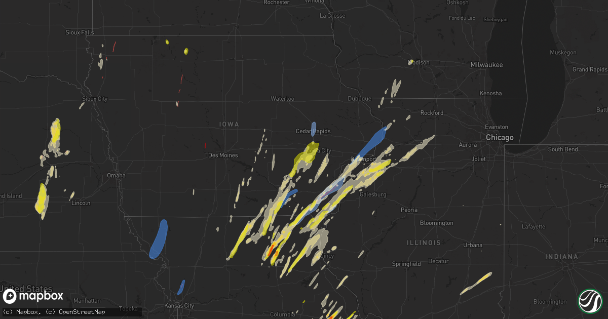
Hail Map on April 16, 2024
Get this storm
April 16 map
$229
one time, instant access
Download today. No call, no setup
Keep the $229
Bought the map and want the full workflow? Apply the entire $229 to a subscription within 7 days. None of it is wasted.
Every map, not just this one
This buys you this map. Subscription and you get every map we run, in the markets you choose from a few cities to whole states to nationwide. Plus real-time alerts the moment a storm fires.
Contact data
Name, contact info, occupancy, even credit band for addresses in the footprint. You go from where it hit to who to call.
Become the source they trust
Unlimited branding weather history reports on demand. You already have the documented answer ready for the property owner, and you are the one who showed up with it.
Property data and RoofTrace estimates
Pull up any address you have got, its value and the exact code rules for that jurisdiction, straight from One Click Code. Then RoofTrace estimates the squares, pitch, and roof value, priced the way you price.
States Impacted by Hail Map on April 16, 2024
Storm reports
Illinois
| Date | Description |
|---|---|
| 04/16/20246:41 PM CDT | Nickel to quarters... Delayed report via x. |
| 04/16/20246:23 PM CDT | Power poles down near hwy 17 and 200th st. Report via x. Time estimated from radar. |
| 04/16/20246:21 PM CDT | Portion of the roof torn off the community bible fellowship church. |
| 04/16/20241:55 PM CDT | Tree down. |
| 04/16/20249:02 AM CDT | A local partner shared photo and reports of damage to the soffits and fencing in a neighborhood along southfield lane in byron. A garage door was reportedly blown in... |
| 04/15/20249:02 PM CDT | Corrects time of previous tstm wnd dmg report from 1 wnw byron. A local partner shared photos and reports of damage to soffits and fencing in a neighborhood along south |
| 04/15/20248:57 PM CDT | Power lines downed in durand. Time estimated by radar. |
| 04/15/20248:34 PM CDT | Occurring right now. |
| 04/15/20248:01 PM CDT | Occurring right now. |
| 04/15/20247:57 PM CDT | Via social media. Time estimated from radar. Location is a best guess estimate. |
| 04/15/20247:51 PM CDT | Report from mping: quarter |
| 04/15/20247:46 PM CDT | Nickel to quarter hail right now. |
| 04/15/20247:45 PM CDT | Social media picture post. |
| 04/15/20247:37 PM CDT | Relayed via broadcast media. Time estimated from radar. Tree damage and power outages from storms. |
| 04/15/20247:37 PM CDT | Several large tree branches broken... Delayed report. Time estimated from radar. |
| 04/15/20247:37 PM CDT | Delayed report. |
| 04/15/20247:35 PM CDT | Report from mping: quarter |
| 04/15/20247:20 PM CDT | Delayed report. Time estimated from radar. |
| 04/15/20247:20 PM CDT | Delayed report. Grain bin blown away. Time estimated by radar. |
Iowa
| Date | Description |
|---|---|
| 04/16/20246:55 PM CDT | Spotter reported 50 to 60 mph winds with at least some 5 inch branches down. |
| 04/16/20246:48 PM CDT | Relayed a report of trees down blocking highway 30 and 30th street west of mill creek parkway on the west side clinton. Time of the event was estimate using radar. |
| 04/16/20246:20 PM CDT | Corrects previous hail report from 2 ese davenport. Dime to quarters near vanderveer park... Delayed report. |
| 04/16/20246:20 PM CDT | 8 inch diameter red cedar tree snapped. |
| 04/16/20246:18 PM CDT | Dvn asos. |
| 04/16/20245:49 PM CDT | A local report indicates 1.00 inch wind near 1 WNW Estherville |
| 04/16/20245:49 PM CDT | A local report indicates 1.00 inch wind near West Burlington |
| 04/16/20245:47 PM CDT | Photo from spotter. Time estimated. |
| 04/16/20245:27 PM CDT | Two trees uprooted and several smaller trees snapped. |
| 04/16/20245:20 PM CDT | Dime to quarters near vanderveer park... Delayed report. |
| 04/16/20245:18 PM CDT | Report from mping: quarter |
| 04/16/20245:14 PM CDT | Tree branches down. |
| 04/16/20245:05 PM CDT | Delayed report. Farm hoop building destroyed. Time estimated based on radar. |
| 04/16/20245:04 PM CDT | Report from mping: trees uprooted or snapped; roof blown off. |
| 04/16/20245:02 PM CDT | Trees down in town... Delayed report. |
| 04/16/20244:49 PM CDT | A local report indicates 72 MPH wind near Stanwood |
| 04/16/20244:46 PM CDT | Report from mping: 3-inch tree limbs broken; power poles broken. |
| 04/16/20244:45 PM CDT | 60 mph gusts estimated fence blown down tree lost limbs. |
| 04/16/20244:40 PM CDT | Ia dot rwis. |
| 04/16/20244:34 PM CDT | Corrects previous tornado report from 4 e salem. A storm spotter was following storm and came across major house damage near jewell ave/salem rd or east of 218 on salem |
| 04/16/20244:27 PM CDT | Report from mping: 1-inch tree limbs broken; shingles blown off. |
| 04/16/20244:24 PM CDT | Em reporting multiple multiple power lines down on riverside drive in iowa city. |
| 04/16/20244:20 PM CDT | Corrects previous tstm wnd dmg report from 1 w iowa city municipality. Two trees uprooted and several smaller trees snapped. |
| 04/16/20244:11 PM CDT | Tree branches down. |
| 04/16/20244:10 PM CDT | Straight line winds estimated at least 60 mph. Also reported half inch hail. |
| 04/16/20244:09 PM CDT | Report from mping: quarter |
| 04/16/20244:09 PM CDT | A local report indicates 1.00 inch wind near 1 E Tiffin |
| 04/16/20244:03 PM CDT | A local report indicates 1.00 inch wind near Mount Sterling |
| 04/16/20244:03 PM CDT | Report from mping: quarter |
| 04/16/20244:00 PM CDT | Old barn along us 52 lost roof and some sides. Time estimated from radar. |
| 04/16/20244:00 PM CDT | A lot of smaller hail. |
| 04/16/20243:57 PM CDT | Corrects previous hail report from 1 sw kalona. Report from mping: quarter |
| 04/16/20243:44 PM CDT | Occurring right now and lots of it. Also estimate winds 50+ mph with a tree down. |
| 04/16/20243:36 PM CDT | Officer located near the intersection of highways 3 and 15 looking to the northeast and viewing a tornado. |
| 04/16/20243:27 PM CDT | Semi jackknifed in the median of highway 151 at mile marker 48 on the linn/jones county. Time estimated using radar. |
| 04/16/20243:18 PM CDT | A local report indicates 58 MPH wind near Eldon |
| 04/16/20243:14 PM CDT | Spotter as well as law enforcement have confirmed a small rope tornado east of palmer. |
| 04/16/20243:08 PM CDT | Semi blown over at milemarker 261. Highway blocked. Time of the event estimated using radar. |
| 04/16/20243:02 PM CDT | An ef-1 tornado touched down northwest of quasqueton... Ia near the pine creek wildlife area... Damaging several trees along 262nd st. The tornado continued to track to |
| 04/16/20243:01 PM CDT | Damage to outbuilding. Time estimated via radar. |
| 04/16/20242:59 PM CDT | A local report indicates a tornado near 2 S Manson |
| 04/16/20242:59 PM CDT | Brief tornado touchdown based on storm survey. |
| 04/16/20242:59 PM CDT | A couple buildings had their ro |
| 04/16/20242:59 PM CDT | A couple buildings had their roofs blown off. |
| 04/16/20242:56 PM CDT | Report from mping: quarter |
| 04/16/20242:56 PM CDT | Report from mping: 1-inch tree limbs broken; shingles blown off. |
| 04/16/20242:53 PM CDT | Along with torrential rain and pea size hail. |
| 04/16/20242:53 PM CDT | Also some hail but size unknown. |
| 04/16/20242:45 PM CDT | A local report indicates 60 MPH wind near Atkins |
| 04/16/20242:35 PM CDT | A local report indicates a tornado near 5 WSW Knierim |
| 04/16/20242:29 PM CDT | Brief tornado lasting approximately 1 min. Tin displayed from roof of outbuilding. |
| 04/16/20242:21 PM CDT | Two grain bins destroyed by nearby thunderstorm outflow. |
| 04/16/20242:11 PM CDT | Location estimated as viewed by emergency manager. |
| 04/16/20242:10 PM CDT | Photo via social media of trailer blown into ditch and destroyed on hwy 75 about 0.5 mile south of merrill. Time estimated via radar. |
| 04/16/20241:59 PM CDT | Confirmed tornado by emergency manager. |
| 04/16/20241:50 PM CDT | Via mping. Social media confirms quarter si |
| 04/16/20241:50 PM CDT | Via mping. Social media confirms quarter size hail in northern sioux city. Time estimated via radar. |
| 04/16/20241:49 PM CDT | Horse lean-to destroyed and horse injured. Broken tree branches. |
| 04/16/20241:46 PM CDT | Brief touchdown in open field reported by hinton police department. |
| 04/16/202412:35 PM CDT | Livestock building sustained damage during structural repair. Time estimated by radar. |
| 04/16/202412:08 PM CDT | Delayed report. Time estimated from radar. Reported at post office. |
| 04/16/202411:10 AM CDT | Outbuilding sheet metal scattered in fields. |
| 04/16/202411:05 AM CDT | Damage to outbuilding. Time estimated from radar. |
| 04/15/20247:09 PM CDT | Asos station kbrl burlington arpt. |
Arkansas
| Date | Description |
|---|---|
| 04/16/20243:53 PM CDT | Report relayed through social media. |
| 04/16/20243:14 PM CDT | Report delivered through social media. |
| 04/16/20243:09 PM CDT | Report delivered through social media. |
West Virginia
| Date | Description |
|---|---|
| 04/16/20243:11 PM CDT | Power lines down near 600 block of gardner road. |
| 04/16/20243:11 PM CDT | Power lines down near 600 block of gardner road. |
| 04/16/20243:10 PM CDT | Quarter size hail shown on a social media post. |
| 04/16/20243:10 PM CDT | Penny to quarter size hail. |
| 04/16/20242:46 PM CDT | Lots of golf ball size hail... With some bigger stones on the ground. |
| 04/16/20242:30 PM CDT | Deck roof collapsed. Photo included with report on social media. |
| 04/16/20242:27 PM CDT | Tree down at 4023 kirby street. |
| 04/16/20242:27 PM CDT | Tree down at ridge drive south charleston. |
| 04/16/20242:27 PM CDT | Tree down at intersection of richmond road and kanawha turnpike. |
| 04/16/20241:48 PM CDT | A local report indicates 1.00 inch wind near 3 ESE Ansted |
Missouri
| Date | Description |
|---|---|
| 04/16/20244:52 PM CDT | Dime to quarter hail right now. |
| 04/16/20244:51 PM CDT | A local report indicates 1.00 inch wind near Kahoka |
| 04/16/20244:25 PM CDT | Reported by wyaconda fire. |
| 04/16/20243:12 PM CDT | Hail ranged from one-quarter inch to one inch in diameter. Time estimated by radar. |
| 04/16/20243:06 PM CDT | Downed wires and power outages southeast of millard. Time estimated from radar. |
| 04/16/20243:02 PM CDT | Several reports of downed wires and power outages north of kirksville. Time estimated from radar. |
| 04/16/20243:00 PM CDT | Report from mping: half dollar |
| 04/16/20242:40 PM CDT | Downed power lines and power outages in the brunswick area. Time estimated from radar. |
| 04/16/20242:30 PM CDT | Downed wires with power outages near ivy drive. Time estimated from radar. |
| 04/16/20242:09 PM CDT | Downed power lines and power outages near route nn. Time estimated from radar. |
| 04/16/20241:58 PM CDT | Multiple power outages reported near u.s. Highway 65 and route uu. Time estimated from radar. |
| 04/16/20241:58 PM CDT | Tree damage across hwy a. Lots of debris. |
| 04/16/20241:56 PM CDT | Several reports of power outages in carrollton west to norborne. Time estimated from radar. |
| 04/16/20241:52 PM CDT | A local report indicates 1.75 inch wind near Jonesburg |
| 04/16/20241:46 PM CDT | Downed wires and power outages in norborne. Time estimated from radar. |
| 04/16/20241:39 PM CDT | Loutre valley farm guest house north of rhineland reported that a lot of quarter size hail fell at their location this afternoon. Time estimated by radar. |
| 04/16/20241:38 PM CDT | Downed wires near lick fork road and route 13. Time estimated from radar. |
| 04/16/20241:32 PM CDT | Multiple reports of wires down and power outages in lexington. Time estimated from radar. |
| 04/16/20241:28 PM CDT | Cell phone antenna blown into power lines and multiple trees down. Time estimated from radar. |
| 04/16/20241:26 PM CDT | Downed tree limbs and minor property damage at a residence in odessa. Time estimated from radar. |
| 04/16/20241:24 PM CDT | Report from mping: half dollar |
| 04/16/20241:19 PM CDT | Spotter reported a 6 inch tree limb down at their own residence and noted a 3 to 4 feet diameter tree was downed at a separate residence near 4th st. And lewis st. Time |
| 04/16/20241:17 PM CDT | Downed wires north of u.s. Highway 50 near the johnson/jackson county line. Time estimated from radar. |
| 04/16/20241:15 PM CDT | 4-6 tree limbs down. |
| 04/16/20241:15 PM CDT | Downed power lines and power outages reported in the orrick area. Time estimated from radar. |
| 04/16/20241:13 PM CDT | Multiple reports of power outages south of oak grove. Time estimated from radar. |
| 04/16/20241:03 PM CDT | Downed power lines near graham road. Time estimated from radar. |
| 04/16/20241:01 PM CDT | Downed power lines and numerous power outages on the eastern side of independence. Time estimated from radar. |
| 04/16/202412:59 PM CDT | A local report indicates 1.00 inch wind near 1 WNW Mexico |
| 04/16/202412:22 PM CDT | Social media video of quarter size hail in atlanta. Time estimated from radar. |
| 04/16/202412:12 PM CDT | Downed tree limbs and wires near college hill st. A 56 mph wind gust occurred at the nws office around this time. Time estimated from the surface observation and radar. |
| 04/16/202412:07 PM CDT | Social media report of quarter size hail northeast of kirksville. Time based on witness report and confirmed by radar. |
| 04/16/202412:04 PM CDT | Clarence police dept stated that dime to quarter size hail fell between noon and 1210pm. Time estimated by radar. |
| 04/16/202411:52 AM CDT | Social media photos of half dollar size hail in brashear. Time estimated from radar. |
| 04/16/202411:50 AM CDT | Tree down on 12th and merill. |
| 04/16/202411:46 AM CDT | Anchored car port reportedly blown away. |
| 04/16/202411:45 AM CDT | A local report indicates 1.25 inch wind near La Plata |
| 04/16/202411:43 AM CDT | Social media report of quarter size hail just east of la plata. Time estimated from radar. |
| 04/16/202411:41 AM CDT | Social media video of ping pong ball sized hail near the intersection of us highway 63 and route nn. Time estimated from radar. |
| 04/16/202411:41 AM CDT | Delayed report. Social media video of golf ball size hail just south of la plata. Time estimated from radar. |
| 04/16/202411:39 AM CDT | Delayed report of quarter size hail in worthington. Time estimated from radar. |
| 04/16/202411:39 AM CDT | Delayed social media report of quarter size hail at the intersection of u.s. Highway 63 and koala road. Time estimated from radar. |
| 04/16/202411:38 AM CDT | Downed trees and wires near 80th avenue. Time based on dispatch report and confirmed by radar. |
| 04/16/202411:37 AM CDT | Corrects previous tstm wnd dmg report from atlanta. Social media video of quarter size hail in atlanta. Time estimated from radar. |
| 04/16/202411:37 AM CDT | Corrects previous tstm wnd dmg report from atlanta. Social media video of quarter size hail in atlanta. Time estimated from radar. |
| 04/16/202411:37 AM CDT | Golf ball sized hail reported at kirksville regional airport. No reports of any damage. |
| 04/16/202411:37 AM CDT | Downed wires near route b. Time estimated from radar. |
| 04/16/202411:37 AM CDT | Delayed report. Hail larger than quarters near atlanta. Time estimated from radar. Location estimated from social media report. |
| 04/16/202411:37 AM CDT | Ping pong ball sized hail reported. |
| 04/16/202411:29 AM CDT | Tree down on powerline. Irrigation pivot blown over. |
| 04/16/202410:31 AM CDT | Reports of downed tree limbs and wires near linden avenue and willis avenue. Time estimated from radar. |
| 04/16/202410:25 AM CDT | Power outages reported in the birmingham area. Time estimated from radar. |
| 04/16/202410:20 AM CDT | Delayed report. Large tree downed at a residence near route j and arnold road. Time estimated from radar. |
| 04/16/202410:17 AM CDT | Several reports of power outages between gladstone and claycomo. Time estimated from radar. |
| 04/16/202410:13 AM CDT | Tree damage near collins road in the camp branch area. Mobile home also flipped over. No injuries reported. Time estimated from radar. |
| 04/16/202410:11 AM CDT | Sporadic tree damage and a portion of a fence blown away near 144th st and mt olivet rd just southeast of smithville. |
| 04/16/202410:11 AM CDT | Downed power lines and power outages near virginia avenue and ne 113th st. Time estimated from radar. |
| 04/16/202410:09 AM CDT | Downed power lines and power outages near 47th street. Time estimated from radar. |
| 04/16/202410:07 AM CDT | Numerous power outages reported between 55th and 75th street near the state border. Time estimated from radar. |
| 04/16/202410:05 AM CDT | Widespread power outages in the lake waukomis area. Time estimated from radar. |
| 04/16/202410:03 AM CDT | Downed power lines and power outages reported east of parkville. Time estimated from radar. |
| 04/16/20249:03 AM CDT | Widespread power outages in the hopkins area. Time confirmed from radar. |
| 04/16/20249:00 AM CDT | *** 1 inj *** nws storm survey confirms a 0.5 mile long ef-1 tornado west of hopkins along state highway ff. |
| 04/16/20248:57 AM CDT | Numerous power outages reported in the pickering area. Time estimated from radar. |
| 04/16/20248:55 AM CDT | Downed power lines and power outages reported north of maryville. Time estimated from radar. |
| 04/16/20248:52 AM CDT | Reports of power lines down and power outages east of maryville. Time estimated from radar. |
| 04/16/20248:52 AM CDT | Report of damage to trees... A machine shed... And a home west of hopkins. Time confirmed from radar. |
| 04/16/20248:51 AM CDT | Several reports of power lines down and power outages in the maryville area. Time estimated from radar and nearby surface observations. |
| 04/16/20248:50 AM CDT | Nws storm survey confirms 3.4 mile long ef-0 tornado just east of maryville with peak winds of 75 mph. |
| 04/16/20248:36 AM CDT | Power lines down and power outages in the skidmore area. Time estimated from radar. |
| 04/16/20248:33 AM CDT | Power lines down and power outages reported. Time estimated from radar. |
| 04/16/20248:33 AM CDT | Power lines down and power outages reported. Time confirmed from radar. |
| 04/16/20248:19 AM CDT | Power lines down and power outages near forest city. Time estimated from radar. |
Kansas
| Date | Description |
|---|---|
| 04/16/20241:53 PM CDT | An ef-0 rated tornado moved north across a part of northern smith county but produced very little damage. Peak winds were estimated at 65 mph along its nearly 7 mile pa |
| 04/16/20249:59 AM CDT | Several reports of power lines down and power outages in the overland park area. Time estimated from radar. |
| 04/16/20249:59 AM CDT | Mping report of tree damage on the northwest side of stanley. Time confirmed from radar. |
| 04/16/20249:55 AM CDT | Downed power lines and power outages near 72nd street. Time estimated from radar. |
| 04/16/20249:54 AM CDT | Tree damage reported on the west side of lenexa. Time estimated from radar. |
| 04/16/20249:51 AM CDT | Downed power lines and power outages east of hillsdale state park. Time estimated from radar. |
| 04/16/20247:34 AM CDT | Ef2 tornado with estimated 118 mph peak winds. 116 yard width with a 2.7 mile path length... Ending at 7:42 am 3 se of virgil. Most severe damage was to steel purlins t |
| 04/16/20247:20 AM CDT | Semi blown over near the intersection of highway 116 and highway 159. |
North Carolina
| Date | Description |
|---|---|
| 04/16/20243:57 PM CDT | Culvert backed up causing flooding along flatwoods school road. |
| 04/16/20243:57 PM CDT | Culvert backed up causing flooding along flatwoods school road. |
| 04/16/20241:20 PM CDT | Two trees down in the pond mountain area. |
| 04/16/20241:20 PM CDT | Two trees down in the pond mountain area. |
Nebraska
| Date | Description |
|---|---|
| 04/16/20242:56 PM CDT | Photo on social media of large tree limb down across coach road south of cedardale road. Time estimated from radar. |
| 04/16/20241:49 PM CDT | Spotter video via social media. |
| 04/16/20241:39 PM CDT | Spotter video via social media. |
| 04/16/20241:39 PM CDT | Ef-0 tornado. Detailed reports from a combination of emergency management... Eyewitnesses... And video evidence from storm spotters indicates this as the path of the to |
| 04/16/20241:18 PM CDT | Eyewitness reports and photo and video evidence show that the long-lived funnel cloud formed a ground circulation that began at approximately 118 local time and lasted |
| 04/16/202412:48 PM CDT | Time estimated. Detached garage damaged at this location. |
| 04/16/202412:37 PM CDT | Ef-0 tornado. A tornado began just west of 190th avenue and about a half mile north of 445th street where it flipped a cattle shed. The tornado then tracked toward the |
| 04/16/202411:39 AM CDT | Emergency manager reporting that the tornado is roping out and touching back down. |
| 04/16/202411:35 AM CDT | Ef-0 tornado. This tornado track is based entirely off of eyewitness reports as there was no damage indicated along the entirety of the intermittent track. Emergency ma |
| 04/16/202411:34 AM CDT | Emergency manager reported a tornado 3 mi sw of platte center. |
| 04/16/20249:03 AM CDT | Part of a small garage roof removed. Damage to a power pole. Nearby trees remain standing. Time estimated based on radar. |
| 04/16/20247:20 AM CDT | Hail on the northeast side of york. Time est from radar. |
| 04/16/20247:10 AM CDT | Report with photo via social media. |
Wisconsin
| Date | Description |
|---|---|
| 04/16/20246:22 PM CDT | Tree damage. |
| 04/15/20249:25 PM CDT | Updates previous tstm wnd dmg report from 1 ssw beloit. Photographs from beloit em and radar imagery indicate that damage to a historic pump house... Trees down... And |
| 04/15/20249:25 PM CDT | Damage to a historic pump house... Trees down... Light poles down. Time estimated from radar. |
| 04/15/20249:24 PM CDT | Reports of 4 trees down in the beloit area. Time estimated based on radar. |
| 04/15/20248:40 PM CDT | Large tree down .25 miles south of state highway 60 on riddle rd in township of lodi. Radar estimated based on radar. |
| 04/15/20248:37 PM CDT | Dane co dispatch relayed reports of tree down around town of dane. Radar time estimated based on radar. |
| 04/15/20248:35 PM CDT | A local report indicates 1.00 inch wind near Middleton |
| 04/15/20247:40 PM CDT | Lafayette co dispatch reported tree down on county road f in fayette. Time estimated based on radar. |
Cities Impacted by Hail Map on April 16, 2024
- Fairmont, NE
- McCool Junction, NE
- York, NE
- Benedict, NE
- Waco, NE
- Stromsburg, NE
- Gresham, NE
- Geneva, NE
- Exeter, NE
- Andalusia, AL
- Red Level, AL
- Shelby, NE
- Greenville, AL
- Rising City, NE
- Columbus, NE
- Bellwood, NE
- Humphrey, NE
- Creston, NE
- Leigh, NE
- Stanton, NE
- Madison, NE
- Hoskins, NE
- Winside, NE
- David City, NE
- Norfolk, NE
- Oregon, MO
- Forest City, MO
- Mound City, MO
- Maitland, MO
- Fillmore, MO
- Highland, KS
- Skidmore, MO
- Graham, MO
- Maryville, MO
- Barnard, MO
- Bolckow, MO
- Burlington Junction, MO
- Clearmont, MO
- Pickering, MO
- Hopkins, MO
- Afton, IA
- Shannon City, IA
- Clarkson, NE
- Kansas City, MO
- Smithville, MO
- Mercer, MO
- Trimble, MO
- Plattsburg, MO
- Kearney, MO
- Corydon, IA
- Chariton, IA
- Millerton, IA
- Princeton, MO
- Platte Center, NE
- Dallas Center, IA
- Minburn, IA
- Bouton, IA
- Ethel, MO
- Elmer, MO
- Atlanta, MO
- La Plata, MO
- Kirksville, MO
- Schuyler, NE
- Lineville, IA
- Allerton, IA
- Russell, IA
- New Cambria, MO
- Williamson, IA
- Monroe, NE
- Green Castle, MO
- Novinger, MO
- Bevier, MO
- Columbia, IA
- Macon, MO
- Lovilia, IA
- Melrose, IA
- Gibbs, MO
- Worthington, MO
- Greentop, MO
- Glenwood, MO
- Unionville, MO
- Queen City, MO
- Coatsville, MO
- Pella, IA
- Knoxville, IA
- Brashear, MO
- Bloomfield, IA
- Livonia, MO
- Baring, MO
- Memphis, MO
- Lancaster, MO
- Hamilton, IA
- Bussey, IA
- Cairo, MO
- Jacksonville, MO
- Moulton, IA
- Clarence, MO
- Anabel, MO
- Drakesville, IA
- Hurdland, MO
- Excello, MO
- Callao, MO
- Sully, IA
- Edina, MO
- Reasnor, IA
- Downing, MO
- Floris, IA
- Ottumwa, IA
- Grinnell, IA
- Leonard, MO
- Lynnville, IA
- Kellogg, IA
- Novelty, MO
- Rutledge, MO
- Gilman, IA
- Montour, IA
- Arbela, MO
- New Sharon, IA
- Rose Hill, IA
- Montezuma, IA
- Barnes City, IA
- Lentner, MO
- Shelbina, MO
- Shelbyville, MO
- Bethel, MO
- La Belle, MO
- Chula, MO
- Laredo, MO
- Humphreys, MO
- Auxvasse, MO
- Columbia, MO
- Searsboro, IA
- Newark, MO
- Lewistown, MO
- Ewing, MO
- Galt, MO
- Milan, MO
- Philadelphia, MO
- Palmyra, MO
- Stoutsville, MO
- Perry, MO
- Middletown, MO
- Kingdom City, MO
- Wellsville, MO
- Madison, MO
- Morrison, MO
- Chamois, MO
- Emerson, NE
- Waterbury, NE
- Milton, IA
- Keosauqua, IA
- Cantril, IA
- Taylor, MO
- Newtown, MO
- Pollock, MO
- Maywood, MO
- La Grange, MO
- Linn, MO
- Hannibal, MO
- Monroe City, MO
- Center, MO
- Monticello, MO
- Canton, MO
- Vandalia, MO
- Curryville, MO
- Bowling Green, MO
- Seward, NE
- Bee, NE
- Williamstown, MO
- Williamsburg, MO
- Portland, MO
- Harris, MO
- Saint Patrick, MO
- Alexandria, MO
- Pleasant Dale, NE
- Garland, NE
- Hermann, MO
- Quincy, IL
- Ursa, IL
- Warsaw, IL
- Rhineland, MO
- Louisiana, MO
- New Florence, MO
- Malcolm, NE
- Raymond, NE
- Hurricane, WV
- Montgomery City, MO
- Jackson, NE
- Hubbard, NE
- Sod, WV
- Griffithsville, WV
- Sumerco, WV
- Yawkey, WV
- Chillicothe, MO
- Sutter, IL
- Howells, NE
- High Hill, MO
- Jonesburg, MO
- Warrenton, MO
- Truxton, MO
- Mexico, MO
- Le Mars, IA
- Hawk Point, MO
- Pittsfield, IL
- Rockport, IL
- Payson, IL
- Silex, MO
- Bellflower, MO
- Alkol, WV
- Orgas, WV
- Seth, WV
- Dodge, NE
- Drury, MO
- Vanzant, MO
- Cabool, MO
- Elk Creek, MO
- Solo, MO
- Houston, MO
- Yolyn, WV
- Quinwood, WV
- Troy, MO
- Green City, MO
- Tornado, WV
- Saint Albans, WV
- Wright City, MO
- Truesdale, MO
- Marthasville, MO
- Bland, MO
- Berger, MO
- Sioux Center, IA
- Maurice, IA
- Ireton, IA
- Hewett, WV
- Clothier, WV
- Jeffrey, WV
- Hull, IA
- Charleston, WV
- Rock Valley, IA
- Hawarden, IA
- Kenna, WV
- Jessieville, AR
- Exline, IA
- Centerville, IA
- Cincinnati, IA
- Smithers, WV
- Versailles, IL
- Rushville, IL
- Mount Sterling, IL
- Yukon, MO
- Eunice, MO
- Rockwell City, IA
- Williamsburg, WV
- Lewisburg, WV
- Crawley, WV
- Hattieville, AR
- Morrilton, AR
- Solgohachia, AR
- Moscow Mills, MO
- Udell, IA
- Unionville, IA
- Perryville, AR
- Paron, AR
- Eskdale, WV
- Foristell, MO
- Cedar Rapids, IA
- Marion, IA
- Hiawatha, IA
- Robins, IA
- Wentzville, MO
- Roland, AR
- Old Monroe, MO
- Mayflower, AR
- Winfield, MO
- Palmer, IA
- Poca, WV
- Springfield, AR
- South Charleston, WV
- Sullivan, MO
- Bourbon, MO
- Cleveland, AR
- Center Ridge, AR
- Avon, IL
- Bigelow, AR
- Maxwelton, WV
- Eldon, IA
- Rock Rapids, IA
- Doon, IA
- Agency, IA
- Leasburg, MO
- Steelville, MO
- Elkview, WV
- Washington, MO
- Hedrick, IA
- Boyden, IA
- George, IA
- Little Rock, IA
- Harrisburg, SD
- Emery, SD
- Chancellor, SD
- Freeman, SD
- Dallas, SD
- Armour, SD
- Canton, SD
- Gregory, SD
- Harrison, SD
- Parkston, SD
- Alvord, IA
- Delmont, SD
- Parker, SD
- Corsica, SD
- Inwood, IA
- Lennox, SD
- Platte, SD
- Marion, SD
- Olivet, SD
- Larchwood, IA
- Winner, SD
- Worthing, SD
- Burke, SD
- Maumelle, AR
- North Little Rock, AR
- Conway, AR
- Sherwood, AR
- Jacksonville, AR
- Vilonia, AR
- Lake Saint Louis, MO
- O'Fallon, MO
- Batavia, IA
- Selma, IA
- Potosi, MO
- Martinsburg, IA
- Sigourney, IA
- Libertyville, IA
- Fairfield, IA
- Gilmore City, IA
- Rolfe, IA
- Fletcher, MO
- Blackwell, MO
- Richwoods, MO
- De Soto, MO
- Ollie, IA
- Packwood, IA
- Richland, IA
- Cabot, AR
- Austin, AR
- Beebe, AR
- Hillsboro, MO
- Dittmer, MO
- El Paso, AR
- Quitman, AR
- Harper, IA
- South English, IA
- Keota, IA
- North English, IA
- Parnell, IA
- Wellman, IA
- Williamsburg, IA
- Kalona, IA
- Oxford, IA
- Kensett, AR
- Searcy, AR
- Higginson, AR
- Riverside, IA
- Iowa City, IA
- McRae, AR
- Garner, AR
- West Chester, IA
- Washington, IA
- Mount Sterling, IA
- Tiffin, IA
- North Liberty, IA
- Coralville, IA
- Luray, MO
- Bonaparte, IA
- Solon, IA
- Pangburn, AR
- Wilburn, AR
- Heber Springs, AR
- Kahoka, MO
- Farmington, IA
- Wayland, IA
- Brighton, IA
- West Point, IA
- Donnellson, IA
- Hillsboro, IA
- Salem, IA
- Swisher, IA
- Carthage, AR
- Sparkman, AR
- Bradford, AR
- Mount Pleasant, IA
- New London, IA
- Wyaconda, MO
- Wayland, MO
- Ainsworth, IA
- Crawfordsville, IA
- Sheridan, AR
- Newport, AR
- Leola, AR
- Marquand, MO
- Owensville, MO
- Steedman, MO
- Mokane, MO
- Mount Union, IA
- Yarmouth, IA
- Argyle, IA
- Mediapolis, IA
- Morning Sun, IA
- Scott, AR
- Amagon, AR
- Fisher, AR
- Grapevine, AR
- Columbus Junction, IA
- Lone Tree, IA
- Conesville, IA
- Nichols, IA
- McNeil, AR
- Magnolia, AR
- Waldo, AR
- Little Rock, AR
- Revere, MO
- Weiner, AR
- Wapello, IA
- Montrose, IA
- Fenton, IA
- Ringsted, IA
- Gorin, MO
- Fort Madison, IA
- Pine Bluff, AR
- Elizabeth, IL
- Stephens, AR
- West Branch, IA
- West Liberty, IA
- Oakville, IA
- New Boston, IL
- Apple River, IL
- Scales Mound, IL
- Shullsburg, WI
- Louann, AR
- Wever, IA
- Denmark, IA
- Danville, IA
- Burlington, IA
- West Burlington, IA
- Middletown, IA
- Hampton, AR
- Camden, AR
- Gratiot, WI
- Darlington, WI
- Illinois City, IL
- Sperry, IA
- Estherville, IA
- Muscatine, IA
- Blue Grass, IA
- Montpelier, IA
- Joy, IL
- Stockton, IL
- Argyle, WI
- South Wayne, WI
- Warren, IL
- Seaton, IL
- Keithsburg, IL
- Harrell, AR
- Taylor Ridge, IL
- Reynolds, IL
- Davenport, IA
- Walcott, IA
- Nora, IL
- Andalusia, IL
- Buffalo, IA
- Oquawka, IL
- Eldridge, IA
- Long Grove, IA
- De Witt, IA
- Camanche, IA
- Princeton, IA
- McCausland, IA
- Woodford, WI
- Aledo, IL
- Milan, IL
- Blanchardville, WI
- Browntown, WI
- Monticello, WI
- Sherrard, IL
- Matherville, IL
- Neoga, IL
- Viola, IL
- Trilla, IL
- Lerna, IL
- Orion, IL
- Lynn Center, IL
- Keokuk, IA
- Coal Valley, IL
- New Windsor, IL
- Nauvoo, IL
- Ashmore, IL
- Charleston, IL
- Geneseo, IL
- Colona, IL
- Kansas, IL
- Bryant, IA
- Clinton, IA
- Goose Lake, IA
- Low Moor, IA
- Cordova, IL
- Fulton, IL
- Thomson, IL
- Sabula, IA
- Savanna, IL
- Mount Carroll, IL
- Hillsdale, IL
- West Point, IL
- Mendon, IL
- Paris, IL
- Grady, AR
- Coatsburg, IL
- Loraine, IL
- Niota, IL
- Little York, IL
- Paloma, IL
- Erie, IL
- Hoopeston, IL
- Gould, AR
- Alexis, IL
- Lanark, IL
- Fowler, IL
- Stuttgart, AR
- Monmouth, IL
- Redmon, IL
- Brocton, IL
- Osco, IL
- Cambridge, IL
- Fenton, IL
- North Henderson, IL
- Atkinson, IL
- Moline, IL
- Morrison, IL
- Alpha, IL
- Prophetstown, IL
- Le Claire, IA
- Forreston, IL
- Ophiem, IL
- Woodhull, IL
- Rio, IL
- Andover, IL
- Lyndon, IL
- Shannon, IL
- Madison, WI
- Middleton, WI
- Baileyville, IL
- Freeport, IL
- Verona, WI
- Gerlaw, IL
- Annawan, IL
- Mineral, IL
- Albion, IL
- Bone Gap, IL
- West Salem, IL
- Tampico, IL
- Sheffield, IL
- New Bedford, IL
- Walnut, IL
- Deer Grove, IL
- Harmon, IL
- Amboy, IL
- Ohio, IL
- Dixon, IL
- Ashton, IL
- Franklin Grove, IL
- West Brooklyn, IL
- Steward, IL
- Rochelle, IL
- Victor, WV
- Lansing, WV
- Stockton, IA
- Virgil, KS
- Rowley, IA
- Independence, IA
- Winthrop, IA
- Corning, IA
- Anita, IA