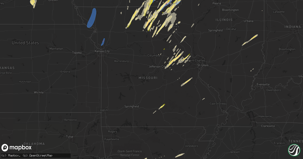
Hail Map in Missouri on April 16, 2024
Get this storm
April 16 map
$229
one time, instant access
Download today. No call, no setup
Keep the $229
Bought the map and want the full workflow? Apply the entire $229 to a subscription within 7 days. None of it is wasted.
Every map, not just this one
This buys you this map. Subscription and you get every map we run, in the markets you choose from a few cities to whole states to nationwide. Plus real-time alerts the moment a storm fires.
Contact data
Name, contact info, occupancy, even credit band for addresses in the footprint. You go from where it hit to who to call.
Become the source they trust
Unlimited branding weather history reports on demand. You already have the documented answer ready for the property owner, and you are the one who showed up with it.
Property data and RoofTrace estimates
Pull up any address you have got, its value and the exact code rules for that jurisdiction, straight from One Click Code. Then RoofTrace estimates the squares, pitch, and roof value, priced the way you price.
Storm reports in Missouri
Missouri
| Date | Description |
|---|---|
| 04/16/20244:52 PM CDT | Dime to quarter hail right now. |
| 04/16/20244:51 PM CDT | A local report indicates 1.00 inch wind near Kahoka |
| 04/16/20244:25 PM CDT | Reported by wyaconda fire. |
| 04/16/20243:12 PM CDT | Hail ranged from one-quarter inch to one inch in diameter. Time estimated by radar. |
| 04/16/20243:06 PM CDT | Downed wires and power outages southeast of millard. Time estimated from radar. |
| 04/16/20243:02 PM CDT | Several reports of downed wires and power outages north of kirksville. Time estimated from radar. |
| 04/16/20243:00 PM CDT | Report from mping: half dollar |
| 04/16/20242:40 PM CDT | Downed power lines and power outages in the brunswick area. Time estimated from radar. |
| 04/16/20242:30 PM CDT | Downed wires with power outages near ivy drive. Time estimated from radar. |
| 04/16/20242:09 PM CDT | Downed power lines and power outages near route nn. Time estimated from radar. |
| 04/16/20241:58 PM CDT | Tree damage across hwy a. Lots of debris. |
| 04/16/20241:58 PM CDT | Multiple power outages reported near u.s. Highway 65 and route uu. Time estimated from radar. |
| 04/16/20241:56 PM CDT | Several reports of power outages in carrollton west to norborne. Time estimated from radar. |
| 04/16/20241:52 PM CDT | A local report indicates 1.75 inch wind near Jonesburg |
| 04/16/20241:46 PM CDT | Downed wires and power outages in norborne. Time estimated from radar. |
| 04/16/20241:39 PM CDT | Loutre valley farm guest house north of rhineland reported that a lot of quarter size hail fell at their location this afternoon. Time estimated by radar. |
| 04/16/20241:38 PM CDT | Downed wires near lick fork road and route 13. Time estimated from radar. |
| 04/16/20241:32 PM CDT | Multiple reports of wires down and power outages in lexington. Time estimated from radar. |
| 04/16/20241:28 PM CDT | Cell phone antenna blown into power lines and multiple trees down. Time estimated from radar. |
| 04/16/20241:26 PM CDT | Downed tree limbs and minor property damage at a residence in odessa. Time estimated from radar. |
| 04/16/20241:24 PM CDT | Report from mping: half dollar |
| 04/16/20241:19 PM CDT | Spotter reported a 6 inch tree limb down at their own residence and noted a 3 to 4 feet diameter tree was downed at a separate residence near 4th st. And lewis st. Time |
| 04/16/20241:17 PM CDT | Downed wires north of u.s. Highway 50 near the johnson/jackson county line. Time estimated from radar. |
| 04/16/20241:15 PM CDT | Downed power lines and power outages reported in the orrick area. Time estimated from radar. |
| 04/16/20241:15 PM CDT | 4-6 tree limbs down. |
| 04/16/20241:13 PM CDT | Multiple reports of power outages south of oak grove. Time estimated from radar. |
| 04/16/20241:03 PM CDT | Downed power lines near graham road. Time estimated from radar. |
| 04/16/20241:01 PM CDT | Downed power lines and numerous power outages on the eastern side of independence. Time estimated from radar. |
| 04/16/202412:59 PM CDT | A local report indicates 1.00 inch wind near 1 WNW Mexico |
| 04/16/202412:22 PM CDT | Social media video of quarter size hail in atlanta. Time estimated from radar. |
| 04/16/202412:12 PM CDT | Downed tree limbs and wires near college hill st. A 56 mph wind gust occurred at the nws office around this time. Time estimated from the surface observation and radar. |
| 04/16/202412:07 PM CDT | Social media report of quarter size hail northeast of kirksville. Time based on witness report and confirmed by radar. |
| 04/16/202412:04 PM CDT | Clarence police dept stated that dime to quarter size hail fell between noon and 1210pm. Time estimated by radar. |
| 04/16/202411:52 AM CDT | Social media photos of half dollar size hail in brashear. Time estimated from radar. |
| 04/16/202411:50 AM CDT | Tree down on 12th and merill. |
| 04/16/202411:46 AM CDT | Anchored car port reportedly blown away. |
| 04/16/202411:45 AM CDT | A local report indicates 1.25 inch wind near La Plata |
| 04/16/202411:43 AM CDT | Social media report of quarter size hail just east of la plata. Time estimated from radar. |
| 04/16/202411:41 AM CDT | Social media video of ping pong ball sized hail near the intersection of us highway 63 and route nn. Time estimated from radar. |
| 04/16/202411:41 AM CDT | Delayed report. Social media video of golf ball size hail just south of la plata. Time estimated from radar. |
| 04/16/202411:39 AM CDT | Delayed social media report of quarter size hail at the intersection of u.s. Highway 63 and koala road. Time estimated from radar. |
| 04/16/202411:39 AM CDT | Delayed report of quarter size hail in worthington. Time estimated from radar. |
| 04/16/202411:38 AM CDT | Downed trees and wires near 80th avenue. Time based on dispatch report and confirmed by radar. |
| 04/16/202411:37 AM CDT | Corrects previous tstm wnd dmg report from atlanta. Social media video of quarter size hail in atlanta. Time estimated from radar. |
| 04/16/202411:37 AM CDT | Corrects previous tstm wnd dmg report from atlanta. Social media video of quarter size hail in atlanta. Time estimated from radar. |
| 04/16/202411:37 AM CDT | Golf ball sized hail reported at kirksville regional airport. No reports of any damage. |
| 04/16/202411:37 AM CDT | Ping pong ball sized hail reported. |
| 04/16/202411:37 AM CDT | Downed wires near route b. Time estimated from radar. |
| 04/16/202411:37 AM CDT | Delayed report. Hail larger than quarters near atlanta. Time estimated from radar. Location estimated from social media report. |
| 04/16/202411:29 AM CDT | Tree down on powerline. Irrigation pivot blown over. |
| 04/16/202410:31 AM CDT | Reports of downed tree limbs and wires near linden avenue and willis avenue. Time estimated from radar. |
| 04/16/202410:25 AM CDT | Power outages reported in the birmingham area. Time estimated from radar. |
| 04/16/202410:20 AM CDT | Delayed report. Large tree downed at a residence near route j and arnold road. Time estimated from radar. |
| 04/16/202410:17 AM CDT | Several reports of power outages between gladstone and claycomo. Time estimated from radar. |
| 04/16/202410:13 AM CDT | Tree damage near collins road in the camp branch area. Mobile home also flipped over. No injuries reported. Time estimated from radar. |
| 04/16/202410:11 AM CDT | Downed power lines and power outages near virginia avenue and ne 113th st. Time estimated from radar. |
| 04/16/202410:11 AM CDT | Sporadic tree damage and a portion of a fence blown away near 144th st and mt olivet rd just southeast of smithville. |
| 04/16/202410:09 AM CDT | Downed power lines and power outages near 47th street. Time estimated from radar. |
| 04/16/202410:07 AM CDT | Numerous power outages reported between 55th and 75th street near the state border. Time estimated from radar. |
| 04/16/202410:05 AM CDT | Widespread power outages in the lake waukomis area. Time estimated from radar. |
| 04/16/202410:03 AM CDT | Downed power lines and power outages reported east of parkville. Time estimated from radar. |
| 04/16/20249:03 AM CDT | Widespread power outages in the hopkins area. Time confirmed from radar. |
| 04/16/20249:00 AM CDT | *** 1 inj *** nws storm survey confirms a 0.5 mile long ef-1 tornado west of hopkins along state highway ff. |
| 04/16/20248:57 AM CDT | Numerous power outages reported in the pickering area. Time estimated from radar. |
| 04/16/20248:55 AM CDT | Downed power lines and power outages reported north of maryville. Time estimated from radar. |
| 04/16/20248:52 AM CDT | Reports of power lines down and power outages east of maryville. Time estimated from radar. |
| 04/16/20248:52 AM CDT | Report of damage to trees... A machine shed... And a home west of hopkins. Time confirmed from radar. |
| 04/16/20248:51 AM CDT | Several reports of power lines down and power outages in the maryville area. Time estimated from radar and nearby surface observations. |
| 04/16/20248:50 AM CDT | Nws storm survey confirms 3.4 mile long ef-0 tornado just east of maryville with peak winds of 75 mph. |
| 04/16/20248:36 AM CDT | Power lines down and power outages in the skidmore area. Time estimated from radar. |
| 04/16/20248:33 AM CDT | Power lines down and power outages reported. Time estimated from radar. |
| 04/16/20248:33 AM CDT | Power lines down and power outages reported. Time confirmed from radar. |
| 04/16/20248:19 AM CDT | Power lines down and power outages near forest city. Time estimated from radar. |
All States Impacted by Hail Map on April 16, 2024
Cities Impacted by Hail Map on April 16, 2024
- Fairmont, NE
- McCool Junction, NE
- York, NE
- Benedict, NE
- Waco, NE
- Stromsburg, NE
- Gresham, NE
- Geneva, NE
- Exeter, NE
- Andalusia, AL
- Red Level, AL
- Shelby, NE
- Greenville, AL
- Rising City, NE
- Columbus, NE
- Bellwood, NE
- Humphrey, NE
- Creston, NE
- Leigh, NE
- Stanton, NE
- Madison, NE
- Hoskins, NE
- Winside, NE
- David City, NE
- Norfolk, NE
- Oregon, MO
- Forest City, MO
- Mound City, MO
- Maitland, MO
- Fillmore, MO
- Highland, KS
- Skidmore, MO
- Graham, MO
- Maryville, MO
- Barnard, MO
- Bolckow, MO
- Burlington Junction, MO
- Clearmont, MO
- Pickering, MO
- Hopkins, MO
- Afton, IA
- Shannon City, IA
- Clarkson, NE
- Kansas City, MO
- Smithville, MO
- Mercer, MO
- Trimble, MO
- Plattsburg, MO
- Kearney, MO
- Corydon, IA
- Chariton, IA
- Millerton, IA
- Princeton, MO
- Platte Center, NE
- Dallas Center, IA
- Minburn, IA
- Bouton, IA
- Ethel, MO
- Elmer, MO
- Atlanta, MO
- La Plata, MO
- Kirksville, MO
- Schuyler, NE
- Lineville, IA
- Allerton, IA
- Russell, IA
- New Cambria, MO
- Williamson, IA
- Monroe, NE
- Green Castle, MO
- Novinger, MO
- Bevier, MO
- Columbia, IA
- Macon, MO
- Lovilia, IA
- Melrose, IA
- Gibbs, MO
- Worthington, MO
- Greentop, MO
- Glenwood, MO
- Unionville, MO
- Queen City, MO
- Coatsville, MO
- Pella, IA
- Knoxville, IA
- Brashear, MO
- Bloomfield, IA
- Livonia, MO
- Baring, MO
- Memphis, MO
- Lancaster, MO
- Hamilton, IA
- Bussey, IA
- Cairo, MO
- Jacksonville, MO
- Moulton, IA
- Clarence, MO
- Anabel, MO
- Drakesville, IA
- Hurdland, MO
- Excello, MO
- Callao, MO
- Sully, IA
- Edina, MO
- Reasnor, IA
- Downing, MO
- Floris, IA
- Ottumwa, IA
- Grinnell, IA
- Leonard, MO
- Lynnville, IA
- Kellogg, IA
- Novelty, MO
- Rutledge, MO
- Gilman, IA
- Montour, IA
- Arbela, MO
- New Sharon, IA
- Rose Hill, IA
- Montezuma, IA
- Barnes City, IA
- Lentner, MO
- Shelbina, MO
- Shelbyville, MO
- Bethel, MO
- La Belle, MO
- Chula, MO
- Laredo, MO
- Humphreys, MO
- Auxvasse, MO
- Columbia, MO
- Searsboro, IA
- Newark, MO
- Lewistown, MO
- Ewing, MO
- Galt, MO
- Milan, MO
- Philadelphia, MO
- Palmyra, MO
- Stoutsville, MO
- Perry, MO
- Middletown, MO
- Kingdom City, MO
- Wellsville, MO
- Madison, MO
- Morrison, MO
- Chamois, MO
- Emerson, NE
- Waterbury, NE
- Milton, IA
- Keosauqua, IA
- Cantril, IA
- Taylor, MO
- Newtown, MO
- Pollock, MO
- Maywood, MO
- La Grange, MO
- Linn, MO
- Hannibal, MO
- Monroe City, MO
- Center, MO
- Monticello, MO
- Canton, MO
- Vandalia, MO
- Curryville, MO
- Bowling Green, MO
- Seward, NE
- Bee, NE
- Williamstown, MO
- Williamsburg, MO
- Portland, MO
- Harris, MO
- Saint Patrick, MO
- Alexandria, MO
- Pleasant Dale, NE
- Garland, NE
- Hermann, MO
- Quincy, IL
- Ursa, IL
- Warsaw, IL
- Rhineland, MO
- Louisiana, MO
- New Florence, MO
- Malcolm, NE
- Raymond, NE
- Hurricane, WV
- Montgomery City, MO
- Jackson, NE
- Hubbard, NE
- Sod, WV
- Griffithsville, WV
- Sumerco, WV
- Yawkey, WV
- Chillicothe, MO
- Sutter, IL
- Howells, NE
- High Hill, MO
- Jonesburg, MO
- Warrenton, MO
- Truxton, MO
- Mexico, MO
- Le Mars, IA
- Hawk Point, MO
- Pittsfield, IL
- Rockport, IL
- Payson, IL
- Silex, MO
- Bellflower, MO
- Alkol, WV
- Orgas, WV
- Seth, WV
- Dodge, NE
- Drury, MO
- Vanzant, MO
- Cabool, MO
- Elk Creek, MO
- Solo, MO
- Houston, MO
- Yolyn, WV
- Quinwood, WV
- Troy, MO
- Green City, MO
- Tornado, WV
- Saint Albans, WV
- Wright City, MO
- Truesdale, MO
- Marthasville, MO
- Bland, MO
- Berger, MO
- Sioux Center, IA
- Maurice, IA
- Ireton, IA
- Hewett, WV
- Clothier, WV
- Jeffrey, WV
- Hull, IA
- Charleston, WV
- Rock Valley, IA
- Hawarden, IA
- Kenna, WV
- Jessieville, AR
- Exline, IA
- Centerville, IA
- Cincinnati, IA
- Smithers, WV
- Versailles, IL
- Rushville, IL
- Mount Sterling, IL
- Yukon, MO
- Eunice, MO
- Rockwell City, IA
- Williamsburg, WV
- Lewisburg, WV
- Crawley, WV
- Hattieville, AR
- Morrilton, AR
- Solgohachia, AR
- Moscow Mills, MO
- Udell, IA
- Unionville, IA
- Perryville, AR
- Paron, AR
- Eskdale, WV
- Foristell, MO
- Cedar Rapids, IA
- Marion, IA
- Hiawatha, IA
- Robins, IA
- Wentzville, MO
- Roland, AR
- Old Monroe, MO
- Mayflower, AR
- Winfield, MO
- Palmer, IA
- Poca, WV
- Springfield, AR
- South Charleston, WV
- Sullivan, MO
- Bourbon, MO
- Cleveland, AR
- Center Ridge, AR
- Avon, IL
- Bigelow, AR
- Maxwelton, WV
- Eldon, IA
- Rock Rapids, IA
- Doon, IA
- Agency, IA
- Leasburg, MO
- Steelville, MO
- Elkview, WV
- Washington, MO
- Hedrick, IA
- Boyden, IA
- George, IA
- Little Rock, IA
- Harrisburg, SD
- Emery, SD
- Chancellor, SD
- Freeman, SD
- Dallas, SD
- Armour, SD
- Canton, SD
- Gregory, SD
- Harrison, SD
- Parkston, SD
- Alvord, IA
- Delmont, SD
- Parker, SD
- Corsica, SD
- Inwood, IA
- Lennox, SD
- Platte, SD
- Marion, SD
- Olivet, SD
- Larchwood, IA
- Winner, SD
- Worthing, SD
- Burke, SD
- Maumelle, AR
- North Little Rock, AR
- Conway, AR
- Sherwood, AR
- Jacksonville, AR
- Vilonia, AR
- Lake Saint Louis, MO
- O'Fallon, MO
- Batavia, IA
- Selma, IA
- Potosi, MO
- Martinsburg, IA
- Sigourney, IA
- Libertyville, IA
- Fairfield, IA
- Gilmore City, IA
- Rolfe, IA
- Fletcher, MO
- Blackwell, MO
- Richwoods, MO
- De Soto, MO
- Ollie, IA
- Packwood, IA
- Richland, IA
- Cabot, AR
- Austin, AR
- Beebe, AR
- Hillsboro, MO
- Dittmer, MO
- El Paso, AR
- Quitman, AR
- Harper, IA
- South English, IA
- Keota, IA
- North English, IA
- Parnell, IA
- Wellman, IA
- Williamsburg, IA
- Kalona, IA
- Oxford, IA
- Kensett, AR
- Searcy, AR
- Higginson, AR
- Riverside, IA
- Iowa City, IA
- McRae, AR
- Garner, AR
- West Chester, IA
- Washington, IA
- Mount Sterling, IA
- Tiffin, IA
- North Liberty, IA
- Coralville, IA
- Luray, MO
- Bonaparte, IA
- Solon, IA
- Pangburn, AR
- Wilburn, AR
- Heber Springs, AR
- Kahoka, MO
- Farmington, IA
- Wayland, IA
- Brighton, IA
- West Point, IA
- Donnellson, IA
- Hillsboro, IA
- Salem, IA
- Swisher, IA
- Carthage, AR
- Sparkman, AR
- Bradford, AR
- Mount Pleasant, IA
- New London, IA
- Wyaconda, MO
- Wayland, MO
- Ainsworth, IA
- Crawfordsville, IA
- Sheridan, AR
- Newport, AR
- Leola, AR
- Marquand, MO
- Owensville, MO
- Steedman, MO
- Mokane, MO
- Mount Union, IA
- Yarmouth, IA
- Argyle, IA
- Mediapolis, IA
- Morning Sun, IA
- Scott, AR
- Amagon, AR
- Fisher, AR
- Grapevine, AR
- Columbus Junction, IA
- Lone Tree, IA
- Conesville, IA
- Nichols, IA
- McNeil, AR
- Magnolia, AR
- Waldo, AR
- Little Rock, AR
- Revere, MO
- Weiner, AR
- Wapello, IA
- Montrose, IA
- Fenton, IA
- Ringsted, IA
- Gorin, MO
- Fort Madison, IA
- Pine Bluff, AR
- Elizabeth, IL
- Stephens, AR
- West Branch, IA
- West Liberty, IA
- Oakville, IA
- New Boston, IL
- Apple River, IL
- Scales Mound, IL
- Shullsburg, WI
- Louann, AR
- Wever, IA
- Denmark, IA
- Danville, IA
- Burlington, IA
- West Burlington, IA
- Middletown, IA
- Hampton, AR
- Camden, AR
- Gratiot, WI
- Darlington, WI
- Illinois City, IL
- Sperry, IA
- Estherville, IA
- Muscatine, IA
- Blue Grass, IA
- Montpelier, IA
- Joy, IL
- Stockton, IL
- Argyle, WI
- South Wayne, WI
- Warren, IL
- Seaton, IL
- Keithsburg, IL
- Harrell, AR
- Taylor Ridge, IL
- Reynolds, IL
- Davenport, IA
- Walcott, IA
- Nora, IL
- Andalusia, IL
- Buffalo, IA
- Oquawka, IL
- Eldridge, IA
- Long Grove, IA
- De Witt, IA
- Camanche, IA
- Princeton, IA
- McCausland, IA
- Woodford, WI
- Aledo, IL
- Milan, IL
- Blanchardville, WI
- Browntown, WI
- Monticello, WI
- Sherrard, IL
- Matherville, IL
- Neoga, IL
- Viola, IL
- Trilla, IL
- Lerna, IL
- Orion, IL
- Lynn Center, IL
- Keokuk, IA
- Coal Valley, IL
- New Windsor, IL
- Nauvoo, IL
- Ashmore, IL
- Charleston, IL
- Geneseo, IL
- Colona, IL
- Kansas, IL
- Bryant, IA
- Clinton, IA
- Goose Lake, IA
- Low Moor, IA
- Cordova, IL
- Fulton, IL
- Thomson, IL
- Sabula, IA
- Savanna, IL
- Mount Carroll, IL
- Hillsdale, IL
- West Point, IL
- Mendon, IL
- Paris, IL
- Grady, AR
- Coatsburg, IL
- Loraine, IL
- Niota, IL
- Little York, IL
- Paloma, IL
- Erie, IL
- Hoopeston, IL
- Gould, AR
- Alexis, IL
- Lanark, IL
- Fowler, IL
- Stuttgart, AR
- Monmouth, IL
- Redmon, IL
- Brocton, IL
- Osco, IL
- Cambridge, IL
- Fenton, IL
- North Henderson, IL
- Atkinson, IL
- Moline, IL
- Morrison, IL
- Alpha, IL
- Prophetstown, IL
- Le Claire, IA
- Forreston, IL
- Ophiem, IL
- Woodhull, IL
- Rio, IL
- Andover, IL
- Lyndon, IL
- Shannon, IL
- Madison, WI
- Middleton, WI
- Baileyville, IL
- Freeport, IL
- Verona, WI
- Gerlaw, IL
- Annawan, IL
- Mineral, IL
- Albion, IL
- Bone Gap, IL
- West Salem, IL
- Tampico, IL
- Sheffield, IL
- New Bedford, IL
- Walnut, IL
- Deer Grove, IL
- Harmon, IL
- Amboy, IL
- Ohio, IL
- Dixon, IL
- Ashton, IL
- Franklin Grove, IL
- West Brooklyn, IL
- Steward, IL
- Rochelle, IL
- Victor, WV
- Lansing, WV
- Stockton, IA
- Virgil, KS
- Rowley, IA
- Independence, IA
- Winthrop, IA
- Corning, IA
- Anita, IA


