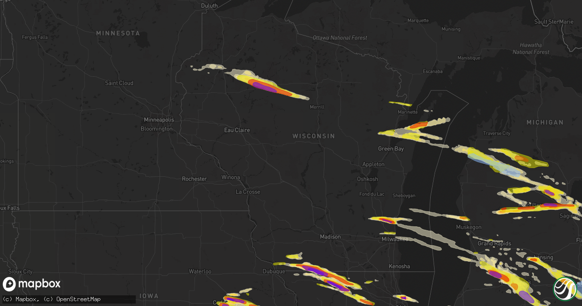
Hail Map in Wisconsin on April 7, 2020
Get this storm
April 7 map
$229
one time, instant access
Download today. No call, no setup
Keep the $229
Bought the map and want the full workflow? Apply the entire $229 to a subscription within 7 days. None of it is wasted.
Every map, not just this one
This buys you this map. Subscription and you get every map we run, in the markets you choose from a few cities to whole states to nationwide. Plus real-time alerts the moment a storm fires.
Contact data
Name, contact info, occupancy, even credit band for addresses in the footprint. You go from where it hit to who to call.
Become the source they trust
Unlimited branding weather history reports on demand. You already have the documented answer ready for the property owner, and you are the one who showed up with it.
Property data and RoofTrace estimates
Pull up any address you have got, its value and the exact code rules for that jurisdiction, straight from One Click Code. Then RoofTrace estimates the squares, pitch, and roof value, priced the way you price.
Storm reports in Wisconsin
Wisconsin
| Date | Description |
|---|---|
| 04/07/20206:25 PM CDT | Corrects previous hail report from 7 s monroe. Delayed report: nws employee observed 1.5 to 1.75 inch hail around the intersection of hgwy-69 and hgwy-26 along the wi/i |
| 04/07/20206:19 PM CDT | Delayed report: large hail around 2 to 2.5 inches |
| 04/07/20206:09 PM CDT | Relayed from social. |
| 04/07/20206:07 PM CDT | Relayed from social media. |
| 04/07/20206:04 PM CDT | A local report indicates 3.00 inch wind near 4 SE BROWNTOWN |
| 04/07/20205:59 PM CDT | Severe thunderstorm is still ongoing. |
| 04/07/20205:58 PM CDT | Relayed from social media. |
| 04/07/20205:54 PM CDT | A local report indicates 1.75 inch wind near SOUTH WAYNE |
| 04/07/20205:36 PM CDT | Delayed report. Facebook report. |
| 04/07/20205:30 PM CDT | Relayed from social media. |
| 04/07/20205:28 PM CDT | Relayed by wtmj. |
| 04/07/20205:26 PM CDT | Delayed report. Some squad car damage due to 2 inch diameter hail. |
| 04/07/20205:19 PM CDT | A local report indicates 1.00 inch wind near MENOMONEE FALLS |
| 04/07/20205:14 PM CDT | Delayed report: nickel to quarter sized hail observed on a farm on county road f northeast of darlington. |
| 04/07/20205:01 PM CDT | A local report indicates 1.00 inch wind near 5 S BELMONT |
| 04/07/20204:47 PM CDT | A few stones up to quarter size. |
| 04/07/20204:22 PM CDT | A local report indicates 1.50 inch wind near 1 NE GRAFTON |
| 04/07/20204:16 PM CDT | Found one hailstone measuring 2.5 inches... Most were golf ball size. |
| 04/07/20204:15 PM CDT | A local report indicates 1.00 inch wind near 2 E GRAFTON |
| 04/07/20204:14 PM CDT | A local report indicates 2.00 inch wind near GRAFTON |
| 04/07/20204:14 PM CDT | Report from mping: quarter |
| 04/07/20204:11 PM CDT | Report from mping: half dollar |
| 04/07/20204:10 PM CDT | Report from april 7th... 2020 storm. |
| 04/07/20204:08 PM CDT | A local report indicates 1.75 inch wind near CEDARBURG |
| 04/07/20204:05 PM CDT | A local report indicates 1.00 inch wind near CRIVITZ |
| 04/07/20203:59 PM CDT | Corrects time on previous hail report from 4 e jackson. Found one hailstone measuring 2.5 inches... Most were golf ball size. |
| 04/07/20203:52 PM CDT | Relayed via wtmj. |
| 04/07/20203:52 PM CDT | A local report indicates 1.75 inch wind near JACKSON |
| 04/07/20203:41 PM CDT | A local report indicates 1.00 inch wind near ALLENTON |
| 04/07/20203:15 PM CDT | Report via social media. |
| 04/07/20202:43 PM CDT | Covering roads. |
| 04/07/202010:21 AM CDT | A local report indicates 1.00 inch wind near 2 N WESTBORO |
| 04/07/202010:15 AM CDT | Relayed via broadcast media. |
| 04/07/20209:30 AM CDT | Photo from twitter and relayed by wqow-tv. Measured based on photo with quarter. Hail lasted six minutes. Near ladysmith airport and dairyland reservoir. Other tweets f |
| 04/07/20209:24 AM CDT | Hailed for several minutes. |
| 04/07/20208:35 AM CDT | Mostly peas... But a few quarters mixed in. |
| 04/07/20208:24 AM CDT | A local report indicates 1.00 inch wind near 1 W HERTEL |
| 04/07/20205:17 AM CDT | At 1017 AM CDT, a severe thunderstorm was located over Westboro, or 17 miles north of Medford, moving east at 50 mph. HAZARD...Ping pong ball size hail. SOURCE...Radar indicated. IMPACT...People and animals outdoors will be injured. Expect damage to roofs, siding, windows, and vehicles. This severe thunderstorm will be near... New Wood Wildlife Area around 1040 AM CDT. Birch Trails Girl Scout Camp around 1050 AM CDT. Merrill and Council Grounds State Park around 1055 AM CDT. Dutch Corners around 1100 AM CDT.Other locations impacted by this severe thunderstorm include Gleason,Dudley, Bill Cross Rapids Wildlife Area, Otis, Bloomville, Doeringand Irma. |
| 04/07/20204:43 AM CDT | At 942 AM CDT, a severe thunderstorm was located near Hawkins, or 17 miles east of Ladysmith, moving southeast at 60 mph. HAZARD...Ping pong ball size hail. SOURCE...Radar indicated. IMPACT...People and animals outdoors will be injured. Expect damage to roofs, siding, windows, and vehicles. Locations impacted include... Rib Lake, Chelsea, Westboro, Camp Forest Spring and Wood Lake. |
| 04/07/20204:39 AM CDT | At 939 AM CDT, a severe thunderstorm was located 8 miles west of Hawkins, or 12 miles northeast of Ladysmith, moving east at 50 mph. HAZARD...Golf ball size hail and 60 mph wind gusts. SOURCE...Radar indicated. IMPACT...People and animals outdoors will be injured. Expect hail damage to roofs, siding, windows, and vehicles. Expect wind damage to roofs, siding, and trees. Locations impacted include... Ogema, Prentice, Spirit, Catawba, and Kennan. |
| 04/07/20204:13 AM CDT | At 913 AM CDT, a severe thunderstorm was located near Exeland, or 15 miles northwest of Ladysmith, moving east at 55 mph. HAZARD...Quarter size hail. SOURCE...Radar indicated. IMPACT...Damage to vehicles is expected. Locations impacted include... Ladysmith, Hawkins, Tony, Glen Flora, Ingram and Rusk County Airport. |
| 04/07/20203:30 AM CDT | At 829 AM CDT, a severe thunderstorm was located near Spooner, moving east at 60 mph. HAZARD...60 mph wind gusts and quarter size hail. SOURCE...Radar indicated. IMPACT...Hail damage to vehicles is expected. Expect wind damage to roofs, siding, and trees. Locations impacted include... Spooner, Shell Lake, Trego, Stone Lake, Birchwood, Radisson, Exeland, Couderay, Edgewater, Sarona, Reserve, Spooner Lake, Lac Courte Oreilles Reservation, Deer Lake, Little Sissabagama Lake, Sissabagama Lake, Angus, and Lac Courte Oreilles. |
| 04/07/20201:16 AM CDT | At 616 PM CDT, a severe thunderstorm was located near Monroe, moving east at 40 mph. This is a very dangerous storm. HAZARD...Baseball size hail. SOURCE...Radar indicated. IMPACT...People and animals outdoors will be severely injured. Expect shattered windows, extensive damage to roofs, siding, and vehicles. Locations impacted include... Brodhead and Juda. |
| 04/07/202012:55 AM CDT | At 555 PM CDT, a severe thunderstorm was located near Apple River, or 15 miles east of Galena, moving east at 60 mph. HAZARD...60 mph wind gusts and quarter size hail. SOURCE...Radar indicated. IMPACT...Hail damage to vehicles is expected. Expect wind damage to roofs, siding, and trees. Locations impacted include... Freeport, Lena, Stockton, Warren, Cedarville, Davis, Woodbine, Dakota, Scales Mound, Apple River, Winslow, Rock City, Ridott, Nora, Schapville, Buena Vista, Rock Grove, Oneco, Guilford and Orangeville. |
| 04/07/202012:40 AM CDT | At 539 PM CDT, a severe thunderstorm was located near Warren, or 10 miles southeast of Darlington, moving east at 50 mph. HAZARD...60 mph wind gusts and quarter size hail. SOURCE...Radar indicated. IMPACT...Hail damage to vehicles is expected. Expect wind damage to roofs, siding, and trees. Locations impacted include... Monroe, Brodhead, Somers, Wiota, South Wayne, Browntown, Gratiot, Juda and Woodford. |
| 04/07/202012:26 AM CDT | At 526 PM CDT, a severe thunderstorm was located over northern Milwaukee, moving east at 45 mph. HAZARD...Quarter size hail. SOURCE...Radar indicated. IMPACT...Damage to vehicles is expected. Locations impacted include... Northern Milwaukee, Wauwatosa, Whitefish Bay, Brown Deer, Fox Point, Bayside, River Hills, Shorewood and UW-Milwaukee. |
| 04/07/202012:06 AM CDT | At 506 PM CDT, severe thunderstorms were located along a line extending from Belmont to near Shullsburg, moving east at 55 mph. HAZARD...60 mph wind gusts and quarter size hail. SOURCE...Radar indicated. IMPACT...Hail damage to vehicles is expected. Expect wind damage to roofs, siding, and trees. Locations impacted include... Darlington, Shullsburg, Belmont, Benton, Argyle, Blanchardville, Somers, Wiota, New Diggings, South Wayne, Lamont, Gratiot, Platte Mounds, Lead Mine, Yellowstone Lake St Park, Leslie and Woodford. |
| 04/06/202011:18 PM CDT | At 417 PM CDT, a severe thunderstorm was located 7 miles north of Menominee, moving east at 50 mph. HAZARD...Quarter size hail. SOURCE...At 405 CDT, a trained spotter reported 1 inch hail in Crivitz. IMPACT...Damage to vehicles is expected. Locations impacted include... Menominee, Wallace, Carbondale and Birch Creek. |
| 04/06/202011:06 PM CDT | At 405 PM CDT, a severe thunderstorm was located near Cedarburg, moving east at 40 mph. HAZARD...Golf ball size hail and 60 mph wind gusts. SOURCE...Radar indicated. IMPACT...People and animals outdoors will be injured. Expect hail damage to roofs, siding, windows, and vehicles. Expect wind damage to roofs, siding, and trees. Locations impacted include... Mequon, Grafton, Cedarburg, Port Washington, Saukville, Thiensville and Newburg.People attending Outdoor Testing at Aurora in Grafton, and OutdoorTesting at Ascension in Mequon should seek safe shelter immediately! |
| 04/06/202010:40 PM CDT | At 340 PM CDT, a severe thunderstorm was located near Slinger, moving east at 50 mph. HAZARD...60 mph wind gusts and quarter size hail. SOURCE...Radar indicated. IMPACT...Hail damage to vehicles is expected. Expect wind damage to roofs, siding, and trees. Locations impacted include... West Bend, Mequon, Hartford, Grafton, Cedarburg, Port Washington, Jackson, Slinger, Saukville, Fredonia, Newburg, Richfield, Addison, Nenno, Waubeka, Holy Hill, Allenton, Saint Lawrence and Kohlsville.People attending Outdoor Testing at Aurora in Grafton, OutdoorTesting at Aurora in Hartford, and Outdoor Testing at Ascension inMequon should seek safe shelter immediately! |
| 04/06/202010:27 PM CDT | At 326 PM CDT, a severe thunderstorm was located 8 miles southwest of Sturgeon Bay, moving east at 50 mph. HAZARD...Quarter size hail. SOURCE...Radar indicated. IMPACT...Damage to vehicles is expected. Locations impacted include... Sturgeon Bay, Forestville, Clay Banks, Vignes, Maplewood, Kolberg and Carnot. |
| 04/06/202010:10 PM CDT | At 309 PM CDT, a severe thunderstorm was located near Sturgeon Bay, moving east-northeast at 50 mph. HAZARD...Quarter size hail. SOURCE...Radar indicated. IMPACT...Damage to vehicles is expected. Locations impacted include... Sturgeon Bay, Jacksonport, Whitefish Bay, Valmy, Institute, Potawatomi State Park, Whitefish Dunes State Park and Carlsville. |
| 04/06/20209:48 PM CDT | At 248 PM CDT, a severe thunderstorm was located 8 miles northwest of Bay Shore Park, moving east at 45 mph. HAZARD...Quarter size hail. SOURCE...Trained weather spotters. IMPACT...Damage to vehicles is expected. Locations impacted include... Sturgeon Bay, Algoma, Brussels, Forestville, Clay Banks, Dyckesville, Rosiere, Shoemaker Point, Duvall and Namur. |
| 04/06/20209:34 PM CDT | At 233 PM CDT, a severe thunderstorm was located 8 miles northeast of Pulaski, or 19 miles northwest of Bay Shore Park, moving east at 40 mph. HAZARD...Quarter size hail. SOURCE...Radar indicated. IMPACT...Damage to vehicles is expected. Locations impacted include... Oconto, Little Suamico, Chase, Oconto Falls, Abrams, Stiles, Pensaukee, Morgan, Sampson and Brookside. |
All States Impacted by Hail Map on April 7, 2020
Cities Impacted by Hail Map on April 7, 2020
- New Kensington, PA
- Natrona Heights, PA
- Brackenridge, PA
- Tarentum, PA
- Bryant, IN
- Keystone, IN
- Geneva, IN
- Hartford City, IN
- Montpelier, IN
- Portland, IN
- Pennville, IN
- Galloway, OH
- Columbus, OH
- Pomeroy, OH
- Middleport, OH
- Marion, IA
- Berwick, PA
- South Solon, OH
- Bloomingburg, OH
- New Holland, OH
- Jeffersonville, OH
- Washington Court House, OH
- Kewanna, IN
- Springville, IA
- Alburnett, IA
- Jamestown, OH
- Cedarville, OH
- Taylor Ridge, IL
- Maple Heights, OH
- Independence, OH
- Bedford, OH
- Cleveland, OH
- Gratiot, WI
- South Whitley, IN
- Patriot, OH
- Gallipolis, OH
- Hope, MI
- Beaverton, MI
- Saegertown, PA
- Conneautville, PA
- Springboro, PA
- Venango, PA
- Joy, IL
- North English, IA
- Wapello, IA
- Letts, IA
- Alexis, IL
- Columbus Junction, IA
- North Henderson, IL
- Kalona, IA
- Riverside, IA
- Galesburg, IL
- Ainsworth, IA
- Muscatine, IA
- Seaton, IL
- New Boston, IL
- Parnell, IA
- Lone Tree, IA
- Wataga, IL
- Conesville, IA
- Aledo, IL
- Wellman, IA
- Clare, IL
- Monroe Center, IL
- Sycamore, IL
- Genoa, IL
- Kingston, IL
- Saint Charles, IL
- Hampshire, IL
- Esmond, IL
- Maple Park, IL
- Kirkland, IL
- Wauseon, OH
- Hopkins, MI
- Coldwater, MI
- Clayton, MI
- Union City, MI
- Martin, MI
- Litchfield, MI
- Marshall, MI
- Jasper, MI
- Hillsdale, MI
- Sand Creek, MI
- Galesburg, MI
- Augusta, MI
- Otsego, MI
- Delton, MI
- Ceresco, MI
- Richland, MI
- Delta, OH
- Homer, MI
- East Leroy, MI
- Jonesville, MI
- Morenci, MI
- Metamora, OH
- Pittsford, MI
- Kalamazoo, MI
- Plainwell, MI
- Osseo, MI
- Lyons, OH
- Fayette, OH
- Bellevue, MI
- Waldron, MI
- Allen, MI
- Hickory Corners, MI
- Burlington, MI
- Allegan, MI
- Battle Creek, MI
- Quincy, MI
- Hudson, MI
- Tekonsha, MI
- Climax, MI
- Arcadia, MI
- Bear Lake, MI
- Forestville, WI
- Algoma, WI
- Marlette, MI
- Brown City, MI
- Shickshinny, PA
- Orangeville, PA
- Clinton, OH
- Marshallville, OH
- Canal Fulton, OH
- Kennan, WI
- Hawkins, WI
- Catawba, WI
- Tony, WI
- Glen Flora, WI
- Ladysmith, WI
- Cedar Rapids, IA
- Colona, IL
- Donahue, IA
- Martelle, IA
- Stockton, IA
- Pleasant Valley, IA
- New Liberty, IA
- Norway, IA
- Anamosa, IA
- Fairfax, IA
- Walcott, IA
- Lowden, IA
- Moline, IL
- Hiawatha, IA
- Eldridge, IA
- Stanwood, IA
- Tipton, IA
- Hampton, IL
- Clarence, IA
- Olin, IA
- Bettendorf, IA
- Atkins, IA
- Wheatland, IA
- Solon, IA
- Silvis, IL
- Mechanicsville, IA
- Mount Vernon, IA
- Davenport, IA
- Calamus, IA
- Durant, IA
- Long Grove, IA
- Wilton, IA
- Lisbon, IA
- East Moline, IL
- Carbon Cliff, IL
- Dixon, IA
- Bennett, IA
- Ely, IA
- Browntown, WI
- Shullsburg, WI
- Orangeville, IL
- Juda, WI
- South Wayne, WI
- Davis, IL
- Monroe, WI
- Darlington, WI
- Rock City, IL
- Winslow, IL
- Dakota, IL
- Slinger, WI
- Grafton, WI
- Saukville, WI
- West Bend, WI
- Jackson, WI
- Hartford, WI
- Cedarburg, WI
- Durand, IL
- Winnebago, IL
- Bourbon, IN
- Alum Bridge, WV
- New Milton, WV
- Weston, WV
- Camden, WV
- Bay City, MI
- Saginaw, MI
- University Center, MI
- Essexville, MI
- Munger, MI
- Potterville, MI
- Grand Ledge, MI
- Rockford, IL
- Pecatonica, IL
- Milwaukee, WI
- Aurora, OH
- Mantua, OH
- McDonald, OH
- Mineral Ridge, OH
- Girard, OH
- Niles, OH
- Warren, OH
- Middleville, MI
- Caledonia, MI
- Star City, IN
- Winamac, IN
- Centerburg, OH
- Croton, OH
- Marietta, OH
- New Matamoras, OH
- Dexter City, OH
- Wingett Run, OH
- Whipple, OH
- Lower Salem, OH
- Macksburg, OH
- Mesick, MI
- Lake City, MI
- Buckley, MI
- Merritt, MI
- Manton, MI
- Kingsley, MI
- Humboldt, IL
- Hersey, MI
- Evart, MI
- Brodnax, VA
- Kenbridge, VA
- Rock Cave, WV
- New Boston, MI
- Belleville, MI
- Lakewood, NY
- Jamestown, NY
- Pinconning, MI
- Leroy, MI
- Cadillac, MI
- Rhodes, MI
- Harrison, MI
- Brethren, MI
- Onekama, MI
- Coleman, MI
- Clare, MI
- Marion, MI
- Midland, MI
- Gladwin, MI
- Linwood, MI
- Tustin, MI
- Wellston, MI
- Kaleva, MI
- Copemish, MI
- Boon, MI
- Auburn, MI
- Harrietta, MI
- Lake, MI
- McBain, MI
- Sanford, MI
- Chippewa Lake, MI
- Mecosta, MI
- Rodney, MI
- Valley City, OH
- Luxemburg, WI
- Casco, WI
- Sobieski, WI
- Pulaski, WI
- Little Suamico, WI
- Abrams, WI
- Brussels, WI
- Sturgeon Bay, WI
- Oconto, WI
- Krakow, WI
- Harrisville, WV
- Cairo, WV
- Milford, IN
- New Paris, IN
- Brunswick, OH
- Litchfield, OH
- Medina, OH
- North Royalton, OH
- Wadsworth, OH
- Spencer, OH
- Strongsville, OH
- Wellington, OH
- Columbia Station, OH
- Hinckley, OH
- Seville, OH
- McConnell, IL
- Winnetka, IL
- Glenview, IL
- Golf, IL
- Chicago, IL
- Wilmette, IL
- Morton Grove, IL
- Evanston, IL
- Skokie, IL
- Jackson, OH
- Thurman, OH
- Oak Hill, OH
- Vinton, OH
- Portage, IN
- Lake Station, IN
- Valparaiso, IN
- Hobart, IN
- Warsaw, VA
- Kilmarnock, VA
- White Stone, VA
- Weems, VA
- Machipongo, VA
- Cape Charles, VA
- Irvington, VA
- Farnham, VA
- Heathsville, VA
- Lancaster, VA
- Bruce, WI
- Exeland, WI
- Lake Odessa, MI
- Pandora, OH
- Bluffton, OH
- Cambridge Springs, PA
- Mcconnelsville, OH
- Blue Rock, OH
- Middlebourne, WV
- Friendly, WV
- Graysville, OH
- Lowell, OH
- Reno, OH
- Caldwell, OH
- Ellenboro, WV
- Cumberland, OH
- Saint Marys, WV
- Pennsboro, WV
- Chandlersville, OH
- Marysville, OH
- Ostrander, OH
- Coxs Mills, WV
- Beachwood, OH
- Shell Lake, WI
- Spooner, WI
- Blanchard, MI
- Shepherd, MI
- Mount Pleasant, MI
- Cherry Valley, IL
- Syracuse, IN
- Millersburg, IN
- Goshen, IN
- Menomonee Falls, WI
- Iowa City, IA
- Walker, WV
- Waverly, WV
- Olmsted Falls, OH
- North Olmsted, OH
- Elyria, OH
- Lorain, OH
- Avon, OH
- North Ridgeville, OH
- Sheffield Lake, OH
- Westlake, OH
- Circleville, OH
- Kingston, OH
- Laurelville, OH
- Croswell, MI
- Preston, MD
- Kenilworth, IL
- Niles, IL
- Des Plaines, IL
- Clifford, MI
- Imlay City, MI
- Fostoria, MI
- Attica, MI
- Mayville, MI
- North Branch, MI
- Nashville, MI
- Vermontville, MI
- Saint Louis, MI
- Merrill, MI
- Breckenridge, MI
- Freeland, MI
- Mchenry, IL
- Weidman, MI
- Berne, IN
- Calumet City, IL
- Plymouth, MI
- Mattawan, MI
- Ottawa Lake, MI
- Toledo, OH
- Erie, MI
- Lambertville, MI
- Temperance, MI
- Victoria, VA
- Lunenburg, VA
- Keysville, VA
- Wanatah, IN
- Hillsdale, IN
- Chillicothe, OH
- Wellston, OH
- Ray, OH
- Beaver, OH
- Emmett, MI
- Lowell, MI
- Alto, MI
- Farwell, MI
- Mecca, IN
- Rosedale, IN
- Montezuma, IN
- Clinton, IN
- Chrisman, IL
- Rockville, IN
- Dana, IN
- Port Washington, WI
- Rubicon, WI
- Robins, IA
- Grand Mound, IA
- Toddville, IA
- Palo, IA
- North Judson, IN
- San Pierre, IN
- Huntsville, OH
- Bellefontaine, OH
- Mount Zion, WV
- Arnoldsburg, WV
- Edmore, MI
- Morley, MI
- Howard City, MI
- Six Lakes, MI
- Newaygo, MI
- Lakeview, MI
- Charlotte, MI
- Dowling, MI
- Dorr, MI
- Shelbyville, MI
- Wayland, MI
- Monterey, IN
- Westville, IN
- Hammond, IN
- Hanna, IN
- Whiting, IN
- Gary, IN
- Dolton, IL
- Alsip, IL
- Union Mills, IN
- La Porte, IN
- La Crosse, IN
- Riverdale, IL
- Blue Island, IL
- East Chicago, IN
- Knox, IN
- Havertown, PA
- Haverford, PA
- Broomall, PA
- Ardmore, PA
- Wynnewood, PA
- Monroe, MI
- Maybee, MI
- Frewsburg, NY
- Russell, PA
- West Union, WV
- Cass, WV
- Arbovale, WV
- Durbin, WV
- Casstown, OH
- Troy, OH
- New Carlisle, OH
- Houghton Lake, MI
- Prudenville, MI
- Belmont, WI
- Pitsburg, OH
- Yellow Springs, OH
- Enon, OH
- West Milton, OH
- Medway, OH
- Tipp City, OH
- South Charleston, OH
- Vandalia, OH
- Greenville, OH
- London, OH
- Springfield, OH
- Laura, OH
- Englewood, OH
- Dayton, OH
- Fairborn, OH
- Ludlow Falls, OH
- Arcanum, OH
- Union City, IN
- Union City, OH
- Southgate, MI
- Allen Park, MI
- Lincoln Park, MI
- Taylor, MI
- Holland, MI
- Hamilton, MI
- Silverwood, MI
- Columbiaville, MI
- Allenton, MI
- Capac, MI
- Otter Lake, MI
- Lapeer, MI
- Melvin, MI
- Peck, MI
- Yale, MI
- Millington, MI
- Cambridge, IL
- Milan, IL
- Moscow, IA
- Reynolds, IL
- Orion, IL
- Sherrard, IL
- Lynn Center, IL
- Illinois City, IL
- West Liberty, IA
- Atalissa, IA
- Andalusia, IL
- Niles, MI
- Grand Rapids, MI
- Saint Marys, OH
- Whitehall, MI
- Sears, MI
- Barryton, MI
- Montague, MI
- Troy, WV
- Willow Springs, IL
- Bidwell, OH
- French Creek, WV
- Helvetia, WV
- Pickens, WV
- Tallmansville, WV
- Mill Creek, WV
- Nappanee, IN
- Walkersville, WV
- Saline, MI
- Hickory Hills, IL
- Palos Hills, IL
- Chicago Ridge, IL
- Bridgeview, IL
- Oak Lawn, IL
- Willowbrook, IL
- Freeport, MI
- Newton Falls, OH
- Leavittsburg, OH
- Massillon, OH
- Doylestown, OH
- North Lawrence, OH
- Buckhannon, WV
- Chelsea, MI
- Kingston, MI
- Vassar, MI
- Grand Rapids, OH
- Federalsburg, MD
- Bridgeville, DE
- Grass Lake, MI
- Munith, MI
- Ann Arbor, MI
- Stockbridge, MI
- Dexter, MI
- Manchester, MI
- Loves Park, IL
- Belvidere, IL
- Rockton, IL
- Machesney Park, IL
- Whitmore Lake, MI
- Mequon, WI
- Byron, IL
- Leaf River, IL
- Crivitz, WI
- Kawkawlin, MI
- Creston, OH
- Crooksville, OH
- Roseville, OH
- Berea, OH
- Brecksville, OH
- Macedonia, OH
- Hudson, OH
- Brookpark, OH
- Northfield, OH
- Chagrin Falls, OH
- Broadview Heights, OH
- Solon, OH
- Avon Lake, OH
- Celoron, NY
- Ashville, NY
- Bemus Point, NY
- Carsonville, MI
- Woodland, MI
- Birchwood, WI
- Buchanan, MI
- Sawyer, MI
- Three Oaks, MI
- New Troy, MI
- Galien, MI
- Nunica, MI
- Coopersville, MI
- Spring Lake, MI
- Mineral Point, WI
- Platteville, WI
- Deltaville, VA
- Callao, VA
- Ireland, WV
- Berkey, OH
- Byron Center, MI
- Blissfield, MI
- Athens, MI
- Adrian, MI
- Swanton, OH
- Dimondale, MI
- Mulliken, MI
- Lansing, MI
- Eaton Rapids, MI
- Mason, MI
- Pleasant Lake, MI
- Holt, MI
- Gregory, MI
- Britton, MI
- Pinckney, MI
- Clinton, MI
- Leslie, MI
- Dansville, MI
- Milan, MI
- Remus, MI
- Rockford, MI
- Belmont, MI
- South Rockwood, MI
- Flat Rock, MI
- Rockwood, MI
- Carleton, MI
- Romulus, MI
- Richwood, OH
- Michigan City, IN
- North Liberty, IA
- Parma, MI
- Albion, MI
- Olivet, MI
- Springport, MI
- Athens, OH
- Tobaccoville, NC
- Rural Hall, NC
- Ripley, NY
- Cuba City, WI
- Poplar Grove, IL
- Ridott, IL
- Warren, IL
- Stillman Valley, IL
- Argyle, WI
- Davis Junction, IL
- Lena, IL
- Freeport, IL
- Garden Prairie, IL
- Stockton, IL
- Nora, IL
- Ogema, WI
- Westboro, WI
- Rib Lake, WI
- Kelleys Island, OH
- Albion, IN
- Lakeview, OH
- Jane Lew, WV
- Hertel, WI
- Hudsonville, MI
- Jerome, MI
- Holland, OH
- Iron Ridge, WI
- Saugatuck, MI
- Douglas, MI
- North Adams, MI
- Zeeland, MI
- Fennville, MI
- Sylvania, OH
- Liberty Center, OH
- Hastings, MI
- Monticello, IA
- Langworthy, IA
- Elberon, VA
- Waverly, VA
- Spring Grove, VA
- Dendron, VA
- Selbyville, WV
- Crawford, WV
- Kanawha Head, WV
- Valley Head, WV
- Napier, WV
- Huttonsville, WV
- Hacker Valley, WV
- Kimmell, IN
- Granville, OH
- Newark, OH
- Hagerstown, MD
- Mechanicsburg, OH
- Urbana, OH
- Muskegon, MI
- Saint John, IN
- Crown Point, IN
- Frankenmuth, MI
- Bridgeport, MI
- Sunfield, MI
- Smithville, WV
- Auburn, WV
- Twin Lake, MI
- Caledonia, IL
- Westmont, IL
- Clarendon Hills, IL
- Downers Grove, IL
- Oak Brook, IL
- Albany, OH
- McArthur, OH
- Hamden, OH
- Wilkesville, OH
- Reese, MI
- Fairgrove, MI
- North Street, MI
- Jeddo, MI
- White Cloud, MI
- Smiths Creek, MI
- Port Huron, MI
- Fort Gratiot, MI
- Akron, MI
- Riverdale, MI
- Avoca, MI
- Memphis, MI
- Caro, MI
- Donnelsville, OH
- Palestine, OH
- Winchester, IN
- Bradford, OH
- New Castle, PA
- Orlando, WV
- Burnsville, WV
- Glenville, WV
- Linn, WV
- Sand Fork, WV
- Stanton, MI
- Delaware, OH
- Central City, IA
- Malvern, PA
- Newtown Square, PA
- West Chester, PA
- Rockbridge, OH
- Logan, OH
- Canton, MI
- Ypsilanti, MI
- Sigel, PA
- Forest Hill, MD
- Jarrettsville, MD
- Centerville, PA
- Guys Mills, PA
- Townville, PA
- Titusville, PA
- Chicago Heights, IL
- Crete, IL
- Steger, IL
- Raymond, OH
- Belle Center, OH
- Rushsylvania, OH
- Laotto, IN
- Avilla, IN
- Union Pier, MI
- New Buffalo, MI
- Novelty, OH
- Saint Helen, MI
- Woodstock, IL
- Newbury, OH
- Kendallville, IN
- Corunna, IN
- Ashley, IN
- Falmouth, MI
- Hillsdale, IL
- Stoutsville, OH
- Adelphi, OH
- Roanoke, IN
- Columbia City, IN
- Lakeside, MI
- Bridgman, MI
- Harbert, MI
- New Carlisle, IN
- Grovertown, IN
- Plymouth, IN
- Fort Wayne, IN
- Yoder, IN
- Slippery Rock, PA
- Coralville, IA
- Big Rapids, MI
- Paris, MI
- Webster, WI
- Siren, WI
- Sarona, WI
- West Chicago, IL
- Warrenville, IL
- Wheaton, IL
- Winfield, IL
- Vesuvius, VA
- Grandview, IA
- Marengo, IL
- Pleasantville, PA
- Butler, WI
- Rocky River, OH
- Columbus Grove, OH
- Menominee, MI
- South Lyon, MI
- Tecumseh, MI
- Dundee, MI
- Roscoe, IL
- Newport, OH
- Belmont, WV
- Cromwell, IN
- Ligonier, IN
- Dayton, PA
- Campbell, OH
- Struthers, OH
- Youngstown, OH
- Canfield, OH
- Lowellville, OH
- Slatyfork, WV
- Willshire, OH
- Decatur, IN
- Monroe, IN
- Rockford, OH
- Mendon, OH
- Argos, IN
- Marion, IN
- Dunkirk, IN
- Groveport, OH
- Lockbourne, OH
- Grove City, OH
- Orient, OH
- Ashville, OH
- Ashtabula, OH
- Goshen, VA
- Craigsville, VA
- Radisson, WI
- Winter, WI
- Merrill, WI
- Porterfield, WI
- Wallace, MI
- Paw Paw, MI
- Chesterton, IN
- Oberlin, OH
- Williamstown, WV
- Horner, WV
- Warsaw, IN
- Etna Green, IN
- Leesburg, IN
- Paris, IL
- New Plymouth, OH
- Creola, OH
- Vicksburg, MI
- Scotts, MI
- Fulton, MI
- Pleasant Hill, OH
- Brookville, OH
- Williamsport, OH
- Mount Sterling, OH
- North Hampton, OH
- Piqua, OH
- Clarksburg, OH
- Xenia, OH
- Covington, OH
- Seaford, DE
- Hometown, IL
- Merrillville, IN
- Griffith, IN
- Midlothian, IL
- Palos Heights, IL
- La Grange, IL
- South Holland, IL
- Palos Park, IL
- Evergreen Park, IL
- Posen, IL
- Crestwood, IL
- Worth, IL
- Darien, IL
- Robbins, IL
- Pierceton, IN
- Claypool, IN
- Erie, PA
- Freeport, PA
- Vandergrift, PA
- Bentley, MI
- Bryn Mawr, PA
- Stone Lake, WI
- Tomahawk, WI
- Alberta, VA
- Hiram, OH
- Gibsonia, PA
- Pewaukee, WI
- Sussex, WI
- Windham, OH
- Du Bois, PA
- Charleston, IL
- Jonesboro, IN
- Upland, IN
- Fowlerton, IN
- Fairmount, IN
- Elwell, MI
- Clarksville, MI
- Ada, MI
- South Bend, IN
- Walkerton, IN
- Bremen, IN
- Lakeville, IN
- Dryden, MI
- Metamora, MI
- Mill Creek, IN
- Rolling Prairie, IN
- Streetsboro, OH
- Lewisville, OH
- Summerfield, OH
- Rutland, OH
- Langsville, OH
- Lawrenceville, VA
- New Haven, IN
- New Marshfield, OH
- South Bloomingville, OH
- Baileys Harbor, WI
- Fish Creek, WI
- Dublin, OH
- Nelsonville, OH
- Amesville, OH
- Millfield, OH
- The Plains, OH
- Chauncey, OH
- Munster, IN
- Dyer, IN
- Lansing, IL
- Hazel Crest, IL
- Homewood, IL
- Highland, IN
- Country Club Hills, IL
- Schererville, IN
- Glenwood, IL
- Ridgeville, IN
- Redkey, IN
- Muncie, IN
- Eaton, IN
- Albany, IN
- Houston, OH
- Enfield, NC
- Ashley, OH
- Grantsburg, WI
- Wyoming, MI
- Edwardsburg, MI
- Berea, WV
- Pullman, WV
- Ossian, IN
- Vermilion, OH
- German Valley, IL
- Petroleum, WV
- Parkersburg, WV
- Elburn, IL
- West Branch, IA
- Rockton, PA
- Carrollton, MI
- Gallipolis Ferry, WV
- Rio Grande, OH
- Haviland, OH
- Paulding, OH
- Marne, MI
- Barronett, WI
- Woodsfield, OH
- Middlebrook, VA
- Raphine, VA
- Ojibwa, WI
- Apple River, IL
- Scales Mound, IL
- Garrettsville, OH
- Limaville, OH
- Atwater, OH
- Alliance, OH
- Inkster, MI
- Westland, MI
- Wayne, MI
- Dearborn Heights, MI
- Mentone, IN
- Warren, PA
- Concord, MI
- Hanover, MI
- Smithfield, VA
- Suffolk, VA
- Arlington Heights, IL
- Northbrook, IL
- Mount Prospect, IL
- Prospect Heights, IL
- Glen Ellyn, IL
- Russia, OH
- Versailles, OH
- Paris, OH
- Louisville, OH
- East Canton, OH
- Sullivan, IL
- Ridgeway, OH
- West Mansfield, OH
- Fort Jennings, OH
- Oxford, IA
- Amanda, OH
- Granger, IN
- Elkhart, IN
- Burbank, OH
- West Salem, OH
- Grandville, MI
- Columbiana, OH
- Leetonia, OH
- Salem, OH
- Henderson, WV
- Apple Grove, WV
- Fletcher, OH
- Willis, MI
- Mishawaka, IN
- Richfield, OH
- Warren, IN
- Van Buren, IN
- Vestaburg, MI
- Portland, MI
- Rittman, OH
- Elgin, IL
- Dekalb, IL
- Cedarville, IL
- Fort Loramie, OH
- Burkettsville, OH
- New Weston, OH
- Saint Henry, OH
- Salamonia, IN
- Rossburg, OH
- Fort Recovery, OH
- Tippecanoe, IN
- Lairdsville, PA
- Hughesville, PA
- Stillwater, PA
- Unityville, PA
- Muncy, PA
- Millville, PA
- Nescopeck, PA
- Benton, PA
- Le Claire, IA
- Port Byron, IL
- Newhall, IA
- Rock Island, IL
- Montpelier, IA
- Blue Grass, IA
- Coal Valley, IL
- Nichols, IA
- Fruitland, IA
- Manistee, MI
- Thompsonville, MI
- Fife Lake, MI
- Houghton Lake Heights, MI
- Ellicott City, MD
- Marriottsville, MD
- Woodstock, MD
- West Friendship, MD
- Sykesville, MD
- Somerset, OH
- New Lexington, OH
- Mount Perry, OH
- Philo, OH
- Washingtonville, OH
- East Sparta, OH
- Canton, OH
- Sunbury, OH
- Oconto Falls, WI
- Dickeyville, WI
- Potosi, WI
- Justice, IL
- Wasco, IL
- Lombard, IL
- Bristol, IN
- Middlebury, IN
- Union, MI
- Kingsford Heights, IN
- Hamlet, IN
- Parkton, MD
- White Hall, MD
- Street, MD
- Aberdeen, MD
- Monkton, MD
- Fallston, MD
- Churchville, MD
- Bel Air, MD
- Brentwood, MD
- Cabin John, MD
- Riverdale, MD
- Potomac, MD
- Capitol Heights, MD
- Chevy Chase, MD
- Hyattsville, MD
- Washington, DC
- Bladensburg, MD
- Takoma Park, MD
- Mount Rainier, MD
- Bethesda, MD
- Glen Echo, MD
- Edinboro, PA
- Mount Solon, VA
- Beverly, OH
- Stewart, OH
- Blue Grass, VA
- Doe Hill, VA
- Webster Springs, WV
- Head Waters, VA
- Cleveland, WV
- Dunmore, WV
- Copen, WV
- Little Hocking, OH
- McDowell, VA
- Mineral Wells, WV
- Brohard, WV
- Cowen, WV
- Heaters, WV
- Belpre, OH
- Diana, WV
- Davisville, WV
- Flatwoods, WV
- Malta, OH
- Churchville, VA
- Big Springs, WV
- Bartow, WV
- Vienna, WV
- Vincent, OH
- West Augusta, VA
- Coal Run, OH
- Fishersville, VA
- Lyndhurst, VA
- Waynesboro, VA
- Swoope, VA
- Stockport, OH
- Williamsville, VA
- Washington, WV
- Elizabeth, WV
- Bergoo, WV
- Sutton, WV
- Monterville, WV
- Cutler, OH
- Stuarts Draft, VA
- Monterey, VA
- Macfarlan, WV
- Chesterhill, OH
- Staunton, VA
- Fleming, OH
- Waterford, OH
- Green Bank, WV
- Craigsville, WV
- Fenwick, WV
- Camden On Gauley, WV
- Tioga, WV
- Summersville, WV
- Calvin, WV
- Slickville, PA
- Bethel Park, PA
- Glassport, PA
- North Lima, OH
- Bolivar, PA
- Bradfordwoods, PA
- New Waterford, OH
- Champion, PA
- Blairsville, PA
- Mount Braddock, PA
- Wickhaven, PA
- Indianola, PA
- Homestead, PA
- New Springfield, OH
- Stoystown, PA
- Clinton, PA
- Turtle Creek, PA
- Midland, PA
- Webster, PA
- Mars, PA
- Perryopolis, PA
- Valencia, PA
- Eighty Four, PA
- Irwin, PA
- Pitcairn, PA
- Donegal, PA
- Waltersburg, PA
- Elizabeth, PA
- Roscoe, PA
- Lawrence, PA
- Jerome, PA
- Warrendale, PA
- Greenock, PA
- Saxonburg, PA
- Boswell, PA
- New Alexandria, PA
- Luxor, PA
- Jeannette, PA
- Crabtree, PA
- Hollsopple, PA
- Youngstown, PA
- Bessemer, PA
- Smithton, PA
- Coraopolis, PA
- Edinburg, PA
- Lowber, PA
- Jones Mills, PA
- East Palestine, OH
- Bakerstown, PA
- Somerset, PA
- Butler, PA
- Tarrs, PA
- Yukon, PA
- Shippingport, PA
- East Liverpool, OH
- Cranberry Township, PA
- Dickerson Run, PA
- Ardara, PA
- Rector, PA
- Harrison City, PA
- Sutersville, PA
- Monessen, PA
- Grindstone, PA
- Bovard, PA
- Windber, PA
- Georgetown, PA
- Indian Head, PA
- Bradenville, PA
- Mill Run, PA
- Derry, PA
- Rochester, PA
- Gray, PA
- Allenport, PA
- Morgan, PA
- Bunola, PA
- Markleton, PA
- Delmont, PA
- Carnegie, PA
- Cuddy, PA
- Elco, PA
- Wyano, PA
- Ruffs Dale, PA
- Mckeesport, PA
- Rogers, OH
- Petersburg, OH
- Koppel, PA
- Josephine, PA
- Negley, OH
- New Florence, PA
- Conway, PA
- Trafford, PA
- Fombell, PA
- Export, PA
- Manor, PA
- Adamsburg, PA
- Duquesne, PA
- North Versailles, PA
- Clarksburg, PA
- Wexford, PA
- Seward, PA
- Hillsville, PA
- Ellwood City, PA
- Apollo, PA
- Finleyville, PA
- Callery, PA
- Vanderbilt, PA
- West Elizabeth, PA
- Evans City, PA
- Hooversville, PA
- Portersville, PA
- Allison Park, PA
- Connellsville, PA
- Seanor, PA
- Black Lick, PA
- Bulger, PA
- Greensburg, PA
- Charleroi, PA
- Meadow Lands, PA
- Penn, PA
- Wampum, PA
- Ohiopyle, PA
- Darragh, PA
- New Brighton, PA
- Dunbar, PA
- Loyalhanna, PA
- Oakmont, PA
- Muse, PA
- Clairton, PA
- Freedom, PA
- West Newton, PA
- Sewickley, PA
- New Stanton, PA
- New Galilee, PA
- Rillton, PA
- Westmoreland City, PA
- Davidsville, PA
- Sturgeon, PA
- Fayette City, PA
- East McKeesport, PA
- Washington, PA
- Cheswick, PA
- Canonsburg, PA
- Normalville, PA
- Beaver Falls, PA
- Everson, PA
- Jennerstown, PA
- Jenners, PA
- Ligonier, PA
- Confluence, PA
- Acme, PA
- Rockwood, PA
- Harwick, PA
- White, PA
- Scottdale, PA
- Aliquippa, PA
- Lemont Furnace, PA
- Grapeville, PA
- Friedens, PA
- Murrysville, PA
- McDonald, PA
- Presto, PA
- Verona, PA
- Coal Center, PA
- Sarver, PA
- West Pittsburg, PA
- Russellton, PA
- Industry, PA
- Saltsburg, PA
- Ambridge, PA
- West Mifflin, PA
- Elton, PA
- New Eagle, PA
- Uniontown, PA
- Crescent, PA
- Avonmore, PA
- Alverton, PA
- Larimer, PA
- Johnstown, PA
- Arona, PA
- Forbes Road, PA
- Beaver, PA
- Pleasant Unity, PA
- Hidden Valley, PA
- Houston, PA
- Wilmerding, PA
- Leechburg, PA
- Hostetter, PA
- Youngwood, PA
- Mount Pleasant, PA
- Acosta, PA
- Robinson, PA
- Braddock, PA
- Dunlevy, PA
- Stahlstown, PA
- Elrama, PA
- New Middletown, OH
- Leetsdale, PA
- East Pittsburgh, PA
- Cecil, PA
- McKees Rocks, PA
- Dawson, PA
- Salix, PA
- Buena Vista, PA
- Venetia, PA
- Bentleyville, PA
- Oakdale, PA
- Monongahela, PA
- Baden, PA
- Smock, PA
- Zelienople, PA
- South Park, PA
- Monroeville, PA
- New Derry, PA
- Donora, PA
- Darlington, PA
- Dravosburg, PA
- Hookstown, PA
- Hannastown, PA
- Hunker, PA
- Monaca, PA
- Lisbon, OH
- Melcroft, PA
- Springdale, PA
- Enon Valley, PA
- Stockdale, PA
- Bairdford, PA
- Strabane, PA
- Claridge, PA
- Bridgeville, PA
- South Heights, PA
- North Apollo, PA
- Pittsburgh, PA
- Van Voorhis, PA
- Star Junction, PA
- Latrobe, PA
- Renfrew, PA
- Creighton, PA
- Harmony, PA
- Herminie, PA
- Belle Vernon, PA
- Quecreek, PA
- Glenshaw, PA
- Southview, PA
- East Vandergrift, PA
- Imperial, PA
- Madison, PA
- Laughlintown, PA
- Frostburg, MD
- Grantsville, MD
- Lonaconing, MD
- Oldtown, MD
- Green Spring, WV
- Glengary, WV
- Berkeley Springs, WV
- Paw Paw, WV
- Great Cacapon, WV
- Cross Junction, VA
- Hedgesville, WV
- Winchester, VA
- Cumberland, MD
- Ridgeley, WV
- Bunker Hill, WV
- Slanesville, WV
- Gerrardstown, WV
- Levels, WV
- Wiley Ford, WV
- Springfield, WV
- Bloomery, WV
- Buckeystown, MD
- Shenandoah Junction, WV
- Shepherdstown, WV
- Washington Grove, MD
- Jefferson, MD
- Kearneysville, WV
- Rockville, MD
- New Market, MD
- Keedysville, MD
- Monrovia, MD
- Barnesville, MD
- Gaithersburg, MD
- Sharpsburg, MD
- Inwood, WV
- Germantown, MD
- Derwood, MD
- Boonsboro, MD
- Boyds, MD
- Clarksburg, MD
- Damascus, MD
- Mount Airy, MD
- Olney, MD
- Braddock Heights, MD
- Martinsburg, WV
- Adamstown, MD
- Dickerson, MD
- Montgomery Village, MD
- Middletown, MD
- Rohrersville, MD
- Brownsville, MD
- Harpers Ferry, WV
- Frederick, MD
- Knoxville, MD
- Ijamsville, MD
- Burkittsville, MD
- Brookeville, MD
- Adrian, WV
- Mabie, WV
- Hot Springs, VA
- Millboro, VA
- Warm Springs, VA
- Bacova, VA
- Monroe, VA
- Madison Heights, VA
- Lynchburg, VA
- Amherst, VA
- Rockbridge Baths, VA
- Lexington, VA
- Buena Vista, VA
- Meherrin, VA
- Roseland, VA
- Tyro, VA
- Greenville, VA
- Montebello, VA
- Steeles Tavern, VA
- Deerfield, VA
- Carrollton, OH
- Navarre, OH
- Cadiz, OH
- Hopedale, OH
- Bowerston, OH
- Sandyville, OH
- Dellroy, OH
- Scio, OH
- Waynesburg, OH
- Sherrodsville, OH
- Amsterdam, OH
- Jewett, OH
- Magnolia, OH
- Mineral City, OH
- Grafton, OH
- Bloomingdale, OH
- Barberton, OH
- Uniontown, OH
- North Canton, OH
- Akron, OH


