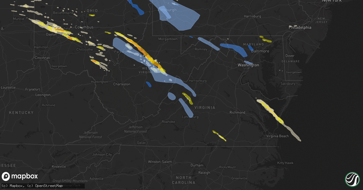
Hail Map in Virginia on April 7, 2020
Get this storm
April 7 map
$229
one time, instant access
Download today. No call, no setup
Keep the $229
Bought the map and want the full workflow? Apply the entire $229 to a subscription within 7 days. None of it is wasted.
Every map, not just this one
This buys you this map. Subscription and you get every map we run, in the markets you choose from a few cities to whole states to nationwide. Plus real-time alerts the moment a storm fires.
Contact data
Name, contact info, occupancy, even credit band for addresses in the footprint. You go from where it hit to who to call.
Become the source they trust
Unlimited branding weather history reports on demand. You already have the documented answer ready for the property owner, and you are the one who showed up with it.
Property data and RoofTrace estimates
Pull up any address you have got, its value and the exact code rules for that jurisdiction, straight from One Click Code. Then RoofTrace estimates the squares, pitch, and roof value, priced the way you price.
Storm reports in Virginia
Virginia
| Date | Description |
|---|---|
| 04/07/20206:10 PM CDT | Trees down. |
| 04/07/20204:05 PM CDT | Tree down on sr 3 between lancaster and lively. Time estimated via radar data. |
| 04/07/20204:00 PM CDT | Trees down at intersection of river rd and white hall rd. |
| 04/07/20203:58 PM CDT | Trees down on hazard rd. Time estimated by radar. |
| 04/07/20203:52 PM CDT | Trees down on coan stage road. Time estimated from radar. |
| 04/07/20203:52 PM CDT | Tree down at jones pl. Off of hwy 301. |
| 04/07/20203:47 PM CDT | Numerous trees down in the town of farnham. |
| 04/07/20203:42 PM CDT | Nickel to quarter size haill at the 911 center. |
| 04/07/20203:35 PM CDT | Trees branches down blocking cople highway near cople elementary school. Time estimated from radar. |
| 04/07/20202:54 PM CDT | Tree down near the intersection of jersey rd. And james madison pkwy. |
| 04/07/20202:47 PM CDT | Tree down at jones pl. Off of hwy 301. |
| 04/07/20201:27 PM CDT | Tree down across us route 1. Time estimated by radar. |
| 04/07/202012:45 PM CDT | Report of hail up to the size of quarters covering the ground between victoria and lunenburg.time estimated from radar. |
| 04/07/20205:50 AM CDT | A line of showers and thunderstorms with strong winds blew a tree down on pearson drive. |
| 04/07/20205:45 AM CDT | Tree down on galilee rd. Time estimated from radar. |
| 04/07/20205:45 AM CDT | Tree down on thomas rd. Time estimated from radar. |
| 04/07/20205:40 AM CDT | Tree down on elon rd. Time estimated from radar. |
| 04/07/20205:30 AM CDT | Several trees blown down in wingina |
| 04/07/20205:26 AM CDT | Screen damage to a front porch in tobacco row area. |
| 04/07/20205:25 AM CDT | Tree blown down on black oak dr at allerton rd. |
| 04/07/20205:22 AM CDT | Numerous trees were reported blown down in the rockfish... Faber... And schuyler areas. |
| 04/07/20205:21 AM CDT | At 1020 PM EDT, a severe thunderstorm was located over Vesuvius, or 12 miles east of Rockbridge Baths, moving southeast at 35 mph. HAZARD...60 mph wind gusts and quarter size hail. SOURCE...Radar indicated. IMPACT...Damaging winds will cause some trees and large branches to fall. This could injure those outdoors, as well as damage homes and vehicles. Roadways may become blocked by downed trees. Localized power outages are possible. Unsecured light objects may become projectiles. Locations impacted include... Shipman, Montebello, Arrington, Lovingston, Bryant, Tye River, Allens Creek, Roseland, Tyro, Buffalo Springs, Norwood, Five Forks, Jonesboro, Wingina, Gladstone and Massies Mill. |
| 04/07/20205:16 AM CDT | At 1016 PM EDT, a severe thunderstorm was located near Brownsburg, or 9 miles northeast of Rockbridge Baths, moving southeast at 30 mph. HAZARD...60 mph wind gusts and quarter size hail. SOURCE...Radar indicated. IMPACT...Hail damage to vehicles is expected. Expect wind damage to roofs, siding, and trees. Locations impacted include... Brownsburg... and Vesuvius. |
| 04/07/20205:15 AM CDT | A line of strong thunderstorms with damaging winds blew down a tree at the intersection of buckhill road and petunia lane in natural bridge. |
| 04/07/20205:04 AM CDT | A line of thunderstorms produced damaging winds that brought a tree down onto valley pike road. |
| 04/07/20205:04 AM CDT | A line of strong storms with damaging winds brought a tree down on high street in the city of lexington. |
| 04/07/20205:03 AM CDT | A line of thunderstorms with damaging winds caused a tree to be blown over on buck hill. |
| 04/07/20205:00 AM CDT | Trees reported down on the 200 block of chestnut ridge road. |
| 04/07/20205:00 AM CDT | Broken branches/split tree trunk from thunderstorm this morning. |
| 04/07/20205:00 AM CDT | Lexington city fire chief reported that from jacktown road into the southern part of lexington city... Multiple large trees were either topped out or completely downed. |
| 04/07/20204:54 AM CDT | A line of storms moving from the north produced a thunderstorm wind gust of 54kt... Or 62mph... At the hot springs awos. |
| 04/07/20204:54 AM CDT | At 954 PM EDT, a severe thunderstorm was located near Bells Valley, or 8 miles northeast of Goshen, moving southeast at 35 mph. HAZARD...60 mph wind gusts and quarter size hail. SOURCE...Radar indicated. IMPACT...Damaging winds will cause some trees and large branches to fall. This could injure those outdoors, as well as damage homes and vehicles. Roadways may become blocked by downed trees. Localized power outages are possible. Unsecured light objects may become projectiles. Locations impacted include... Craigsville, Greenville, Augusta Springs, Middlebrook, Deerfield, Summerdean and Spottswood. |
| 04/07/20204:50 AM CDT | Four or five trees were reported blown down in the riverheads area. |
| 04/07/20204:48 AM CDT | A couple of trees were reported blown down in the middlebrook area. |
| 04/07/20204:42 AM CDT | A tree was reported blown down in churchville. |
| 04/07/20204:42 AM CDT | Tree downed on a house near buffalo gap |
| 04/07/20204:39 AM CDT | A line of strong thunderstorms produced wind damage to the communications tower for bath co. 911 center. |
| 04/07/20204:38 AM CDT | A line of thunderstorms coming from the north produced strong winds that caused a tree to fall on a home south of hot springs. |
| 04/07/20204:30 AM CDT | A line of strong thunderstorms brought several trees down over mountain valley road near blowing springs campground. |
| 04/07/20204:25 AM CDT | Tree down in the 7800 block of blenheim road. |
| 04/07/20204:17 AM CDT | Tree reported down on thorny bottom lane near potomac river road. |
| 04/07/20204:14 AM CDT | Trees/branches downed. Two camper trailers overturned. Pole barn structure collapsed with some material impacting a nearby house. |
| 04/07/20204:12 AM CDT | Tree down on va-655 weyburn road near va-20 constitution highway |
| 04/07/20204:04 AM CDT | Multiple trees were reported blown down near the intersection of va-609 scuffletown and blue hill drive |
| 04/07/20204:02 AM CDT | A tree was blown down in the 6600 block of us-29 north seminole trail |
| 04/07/20203:58 AM CDT | A tree was blown down in the 5000 block of va-609 west hoover road |
| 04/07/20203:43 AM CDT | At 843 PM EDT, a severe thunderstorm was located near Cass Scenic Railroad, moving southeast at 35 mph. HAZARD...60 mph wind gusts and quarter size hail. SOURCE...Radar indicated. IMPACT...Damaging winds will cause some trees and large branches to fall. This could injure those outdoors, as well as damage homes and vehicles. Roadways may become blocked by downed trees. Localized power outages are possible. Unsecured light objects may become projectiles. Locations impacted include... Williamsville, Clover Creek, Mustoe, Vanderpool, Bolar and Mill Gap. |
| 04/07/20203:41 AM CDT | At 840 PM EDT, a severe thunderstorm was located near Cass Scenic Railroad, moving southeast at 40 mph. HAZARD...60 mph wind gusts and half dollar size hail. SOURCE...Radar indicated. IMPACT...Hail damage to vehicles is expected. Expect wind damage to roofs, siding, and trees. Locations impacted include... Cass Scenic Railroad, Greenbank, Durbin, Dunmore, Arbovale, Cheat Bridge, Bartow, Valley Head and Boyer. |
| 04/07/20203:25 AM CDT | Trees report down on the 2800 block of mustang drive. |
| 04/07/20203:21 AM CDT | Tree and power lines report down on 18th st between n pocomoke st and n ohio street/ |
| 04/07/20203:19 AM CDT | Tree down near woodlawn avenue at cavalier trail. |
| 04/07/20202:55 AM CDT | Several trees were blown down and shingles were torn off at least one house on harrison st in leesburg. |
| 04/07/20202:53 AM CDT | A tree was blown down on va-690 silcott springs rd near shoemaker school rd |
| 04/07/20202:52 AM CDT | Multiple reports of trees down between marshall dr. Ne and edwards ferry rd. Ne... Primarily east of mayfair dr. Ne and west of the leesburg bypass. |
| 04/07/20202:30 AM CDT | A tree was blown down onto power lines in the 100 block of red fox trail. |
| 04/07/20202:25 AM CDT | A tree was blown down across the roadway on the 1400 block of pack horse rd. |
| 04/07/20202:22 AM CDT | A tree was blown down across the roadway in the 600 block of ebenezer church rd. |
| 04/07/20201:47 AM CDT | At 647 PM EDT, a severe thunderstorm was located over Burrowsville, or near Claremont, moving southeast at 35 mph. HAZARD...60 mph wind gusts. SOURCE...Radar indicated. IMPACT...Expect damage to trees and powerlines. This severe thunderstorm will be near, Claremont and Cabin Point around 650 PM EDT. Waverly around 705 PM EDT. Dendron and Elberon around 710 PM EDT. Wakefield around 715 PM EDT.Other locations impacted by this severe thunderstorm include TaylorsCorner, Booth Fork, Carsley, Spring Grove, Brandon, Ellis Fork, DelkCrossroads, Barham, Gwaltney Corner and Oak Hill Corner. |
| 04/07/202012:35 AM CDT | At 535 PM EDT, severe thunderstorms were located along a line extending from near Tangier to 7 miles east of Gwynn, moving east at 35 mph. HAZARD...60 mph wind gusts and quarter size hail. SOURCE...Radar indicated. IMPACT...Minor damage to vehicles is possible. Expect wind damage to trees and powerlines. Severe thunderstorms will be near, Tangier around 540 PM EDT. Exmore, Nassawadox and Willis Wharf around 605 PM EDT. Parksley around 615 PM EDT.Other locations impacted by these severe thunderstorms includeCapeville, Kiptopeke State Park, Harborton, Melfa, Mappsville,Eastville, Saxis, Franktown, Wallops Island and Temperanceville. |
| 04/06/202011:22 PM CDT | At 422 PM EDT, a severe thunderstorm was located near Madison, moving east at 45 mph. HAZARD...60 mph wind gusts. SOURCE...Radar indicated. IMPACT...Damaging winds will cause some trees and large branches to fall. This could injure those outdoors, as well as damage homes and vehicles. Roadways may become blocked by downed trees. Localized power outages are possible. Unsecured light objects may become projectiles. Locations impacted include... Orange, Madison, Brightwood, Mine Run, Oakpark, Everona, Verdiersville, Locust Grove, Flat Run, Nasons, Winston, Madison Mills, Mitchells, Lake Of The Woods, Leon, Unionville, Locust Dale, Raccoon Ford, Rhoadesville and Rapidan. |
| 04/06/202011:13 PM CDT | At 413 PM EDT, a severe thunderstorm was located 7 miles west of Spotsylvania, or 14 miles northeast of Mineral, moving east at 35 mph. HAZARD...60 mph wind gusts and quarter size hail. SOURCE...Radar indicated. IMPACT...Damaging winds will cause some trees and large branches to fall. This could injure those outdoors, as well as damage homes and vehicles. Roadways may become blocked by downed trees. Localized power outages are possible. Unsecured light objects may become projectiles. Locations impacted include... Massaponax, Spotsylvania, Logan, Brokenburg, Post Oak, Thornburg, Snell, Alsop and Gatewood. |
| 04/06/20209:46 PM CDT | At 246 PM EDT, a severe thunderstorm was located near Stony Creek, or 10 miles northeast of Purdy, moving southeast at 30 mph. HAZARD...60 mph wind gusts and quarter size hail. SOURCE...Radar indicated. IMPACT...Minor damage to vehicles is possible. Expect wind damage to trees and powerlines. This severe thunderstorm will be near, Sussex around 300 PM EDT. Franklin, Courtland, Sedley and Hunterdale around 330 PM EDT.Other locations impacted by this severe thunderstorm includeVicksville, Berlin, Booker, Yale, Lumberton, Manry, Huske, Littleton,Hilda and Owens. |
| 04/06/20209:22 PM CDT | Quarter sized hail fell at a fuel city gas station in raphine off exit 205 along i-81. |
| 04/06/20209:19 PM CDT | Hail accumulating 2 inches deep on i-81 near spotswood caused multiple accidents and partially closed the highway |
| 04/06/20208:58 PM CDT | 1 inch hail covering ground in craigsville - reported by broadcast meteorologist via twitter |
| 04/06/20208:43 PM CDT | At 142 PM EDT, a severe thunderstorm was located over Lunenburg, or over Victoria, moving southeast at 25 mph. HAZARD...60 mph wind gusts and quarter size hail. SOURCE...Radar indicated. IMPACT...Minor damage to vehicles is possible. Expect wind damage to trees and powerlines. This severe thunderstorm will be near, Kenbridge around 155 PM EDT. Dundas around 215 PM EDT. South Hill around 225 PM EDT. Brodnax and La Crosse around 230 PM EDT.Other locations impacted by this severe thunderstorm include Gary,Bacons Fork, Cochran, Wilburn, Gills Corner, Loves Mill,Meredithville, Forksville, Lafoon Corner and Danieltown.People at South Hill Family Medicine should seek safe shelterimmediately! |
All States Impacted by Hail Map on April 7, 2020
Cities Impacted by Hail Map on April 7, 2020
- New Kensington, PA
- Natrona Heights, PA
- Brackenridge, PA
- Tarentum, PA
- Bryant, IN
- Keystone, IN
- Geneva, IN
- Hartford City, IN
- Montpelier, IN
- Portland, IN
- Pennville, IN
- Galloway, OH
- Columbus, OH
- Pomeroy, OH
- Middleport, OH
- Marion, IA
- Berwick, PA
- South Solon, OH
- Bloomingburg, OH
- New Holland, OH
- Jeffersonville, OH
- Washington Court House, OH
- Kewanna, IN
- Springville, IA
- Alburnett, IA
- Jamestown, OH
- Cedarville, OH
- Taylor Ridge, IL
- Maple Heights, OH
- Independence, OH
- Bedford, OH
- Cleveland, OH
- Gratiot, WI
- South Whitley, IN
- Patriot, OH
- Gallipolis, OH
- Hope, MI
- Beaverton, MI
- Saegertown, PA
- Conneautville, PA
- Springboro, PA
- Venango, PA
- Joy, IL
- North English, IA
- Wapello, IA
- Letts, IA
- Alexis, IL
- Columbus Junction, IA
- North Henderson, IL
- Kalona, IA
- Riverside, IA
- Galesburg, IL
- Ainsworth, IA
- Muscatine, IA
- Seaton, IL
- New Boston, IL
- Parnell, IA
- Lone Tree, IA
- Wataga, IL
- Conesville, IA
- Aledo, IL
- Wellman, IA
- Clare, IL
- Monroe Center, IL
- Sycamore, IL
- Genoa, IL
- Kingston, IL
- Saint Charles, IL
- Hampshire, IL
- Esmond, IL
- Maple Park, IL
- Kirkland, IL
- Wauseon, OH
- Hopkins, MI
- Coldwater, MI
- Clayton, MI
- Union City, MI
- Martin, MI
- Litchfield, MI
- Marshall, MI
- Jasper, MI
- Hillsdale, MI
- Sand Creek, MI
- Galesburg, MI
- Augusta, MI
- Otsego, MI
- Delton, MI
- Ceresco, MI
- Richland, MI
- Delta, OH
- Homer, MI
- East Leroy, MI
- Jonesville, MI
- Morenci, MI
- Metamora, OH
- Pittsford, MI
- Kalamazoo, MI
- Plainwell, MI
- Osseo, MI
- Lyons, OH
- Fayette, OH
- Bellevue, MI
- Waldron, MI
- Allen, MI
- Hickory Corners, MI
- Burlington, MI
- Allegan, MI
- Battle Creek, MI
- Quincy, MI
- Hudson, MI
- Tekonsha, MI
- Climax, MI
- Arcadia, MI
- Bear Lake, MI
- Forestville, WI
- Algoma, WI
- Marlette, MI
- Brown City, MI
- Shickshinny, PA
- Orangeville, PA
- Clinton, OH
- Marshallville, OH
- Canal Fulton, OH
- Kennan, WI
- Hawkins, WI
- Catawba, WI
- Tony, WI
- Glen Flora, WI
- Ladysmith, WI
- Cedar Rapids, IA
- Colona, IL
- Donahue, IA
- Martelle, IA
- Stockton, IA
- Pleasant Valley, IA
- New Liberty, IA
- Norway, IA
- Anamosa, IA
- Fairfax, IA
- Walcott, IA
- Lowden, IA
- Moline, IL
- Hiawatha, IA
- Eldridge, IA
- Stanwood, IA
- Tipton, IA
- Hampton, IL
- Clarence, IA
- Olin, IA
- Bettendorf, IA
- Atkins, IA
- Wheatland, IA
- Solon, IA
- Silvis, IL
- Mechanicsville, IA
- Mount Vernon, IA
- Davenport, IA
- Calamus, IA
- Durant, IA
- Long Grove, IA
- Wilton, IA
- Lisbon, IA
- East Moline, IL
- Carbon Cliff, IL
- Dixon, IA
- Bennett, IA
- Ely, IA
- Browntown, WI
- Shullsburg, WI
- Orangeville, IL
- Juda, WI
- South Wayne, WI
- Davis, IL
- Monroe, WI
- Darlington, WI
- Rock City, IL
- Winslow, IL
- Dakota, IL
- Slinger, WI
- Grafton, WI
- Saukville, WI
- West Bend, WI
- Jackson, WI
- Hartford, WI
- Cedarburg, WI
- Durand, IL
- Winnebago, IL
- Bourbon, IN
- Alum Bridge, WV
- New Milton, WV
- Weston, WV
- Camden, WV
- Bay City, MI
- Saginaw, MI
- University Center, MI
- Essexville, MI
- Munger, MI
- Potterville, MI
- Grand Ledge, MI
- Rockford, IL
- Pecatonica, IL
- Milwaukee, WI
- Aurora, OH
- Mantua, OH
- McDonald, OH
- Mineral Ridge, OH
- Girard, OH
- Niles, OH
- Warren, OH
- Middleville, MI
- Caledonia, MI
- Star City, IN
- Winamac, IN
- Centerburg, OH
- Croton, OH
- Marietta, OH
- New Matamoras, OH
- Dexter City, OH
- Wingett Run, OH
- Whipple, OH
- Lower Salem, OH
- Macksburg, OH
- Mesick, MI
- Lake City, MI
- Buckley, MI
- Merritt, MI
- Manton, MI
- Kingsley, MI
- Humboldt, IL
- Hersey, MI
- Evart, MI
- Brodnax, VA
- Kenbridge, VA
- Rock Cave, WV
- New Boston, MI
- Belleville, MI
- Lakewood, NY
- Jamestown, NY
- Pinconning, MI
- Leroy, MI
- Cadillac, MI
- Rhodes, MI
- Harrison, MI
- Brethren, MI
- Onekama, MI
- Coleman, MI
- Clare, MI
- Marion, MI
- Midland, MI
- Gladwin, MI
- Linwood, MI
- Tustin, MI
- Wellston, MI
- Kaleva, MI
- Copemish, MI
- Boon, MI
- Auburn, MI
- Harrietta, MI
- Lake, MI
- McBain, MI
- Sanford, MI
- Chippewa Lake, MI
- Mecosta, MI
- Rodney, MI
- Valley City, OH
- Luxemburg, WI
- Casco, WI
- Sobieski, WI
- Pulaski, WI
- Little Suamico, WI
- Abrams, WI
- Brussels, WI
- Sturgeon Bay, WI
- Oconto, WI
- Krakow, WI
- Harrisville, WV
- Cairo, WV
- Milford, IN
- New Paris, IN
- Brunswick, OH
- Litchfield, OH
- Medina, OH
- North Royalton, OH
- Wadsworth, OH
- Spencer, OH
- Strongsville, OH
- Wellington, OH
- Columbia Station, OH
- Hinckley, OH
- Seville, OH
- McConnell, IL
- Winnetka, IL
- Glenview, IL
- Golf, IL
- Chicago, IL
- Wilmette, IL
- Morton Grove, IL
- Evanston, IL
- Skokie, IL
- Jackson, OH
- Thurman, OH
- Oak Hill, OH
- Vinton, OH
- Portage, IN
- Lake Station, IN
- Valparaiso, IN
- Hobart, IN
- Warsaw, VA
- Kilmarnock, VA
- White Stone, VA
- Weems, VA
- Machipongo, VA
- Cape Charles, VA
- Irvington, VA
- Farnham, VA
- Heathsville, VA
- Lancaster, VA
- Bruce, WI
- Exeland, WI
- Lake Odessa, MI
- Pandora, OH
- Bluffton, OH
- Cambridge Springs, PA
- Mcconnelsville, OH
- Blue Rock, OH
- Middlebourne, WV
- Friendly, WV
- Graysville, OH
- Lowell, OH
- Reno, OH
- Caldwell, OH
- Ellenboro, WV
- Cumberland, OH
- Saint Marys, WV
- Pennsboro, WV
- Chandlersville, OH
- Marysville, OH
- Ostrander, OH
- Coxs Mills, WV
- Beachwood, OH
- Shell Lake, WI
- Spooner, WI
- Blanchard, MI
- Shepherd, MI
- Mount Pleasant, MI
- Cherry Valley, IL
- Syracuse, IN
- Millersburg, IN
- Goshen, IN
- Menomonee Falls, WI
- Iowa City, IA
- Walker, WV
- Waverly, WV
- Olmsted Falls, OH
- North Olmsted, OH
- Elyria, OH
- Lorain, OH
- Avon, OH
- North Ridgeville, OH
- Sheffield Lake, OH
- Westlake, OH
- Circleville, OH
- Kingston, OH
- Laurelville, OH
- Croswell, MI
- Preston, MD
- Kenilworth, IL
- Niles, IL
- Des Plaines, IL
- Clifford, MI
- Imlay City, MI
- Fostoria, MI
- Attica, MI
- Mayville, MI
- North Branch, MI
- Nashville, MI
- Vermontville, MI
- Saint Louis, MI
- Merrill, MI
- Breckenridge, MI
- Freeland, MI
- Mchenry, IL
- Weidman, MI
- Berne, IN
- Calumet City, IL
- Plymouth, MI
- Mattawan, MI
- Ottawa Lake, MI
- Toledo, OH
- Erie, MI
- Lambertville, MI
- Temperance, MI
- Victoria, VA
- Lunenburg, VA
- Keysville, VA
- Wanatah, IN
- Hillsdale, IN
- Chillicothe, OH
- Wellston, OH
- Ray, OH
- Beaver, OH
- Emmett, MI
- Lowell, MI
- Alto, MI
- Farwell, MI
- Mecca, IN
- Rosedale, IN
- Montezuma, IN
- Clinton, IN
- Chrisman, IL
- Rockville, IN
- Dana, IN
- Port Washington, WI
- Rubicon, WI
- Robins, IA
- Grand Mound, IA
- Toddville, IA
- Palo, IA
- North Judson, IN
- San Pierre, IN
- Huntsville, OH
- Bellefontaine, OH
- Mount Zion, WV
- Arnoldsburg, WV
- Edmore, MI
- Morley, MI
- Howard City, MI
- Six Lakes, MI
- Newaygo, MI
- Lakeview, MI
- Charlotte, MI
- Dowling, MI
- Dorr, MI
- Shelbyville, MI
- Wayland, MI
- Monterey, IN
- Westville, IN
- Hammond, IN
- Hanna, IN
- Whiting, IN
- Gary, IN
- Dolton, IL
- Alsip, IL
- Union Mills, IN
- La Porte, IN
- La Crosse, IN
- Riverdale, IL
- Blue Island, IL
- East Chicago, IN
- Knox, IN
- Havertown, PA
- Haverford, PA
- Broomall, PA
- Ardmore, PA
- Wynnewood, PA
- Monroe, MI
- Maybee, MI
- Frewsburg, NY
- Russell, PA
- West Union, WV
- Cass, WV
- Arbovale, WV
- Durbin, WV
- Casstown, OH
- Troy, OH
- New Carlisle, OH
- Houghton Lake, MI
- Prudenville, MI
- Belmont, WI
- Pitsburg, OH
- Yellow Springs, OH
- Enon, OH
- West Milton, OH
- Medway, OH
- Tipp City, OH
- South Charleston, OH
- Vandalia, OH
- Greenville, OH
- London, OH
- Springfield, OH
- Laura, OH
- Englewood, OH
- Dayton, OH
- Fairborn, OH
- Ludlow Falls, OH
- Arcanum, OH
- Union City, IN
- Union City, OH
- Southgate, MI
- Allen Park, MI
- Lincoln Park, MI
- Taylor, MI
- Holland, MI
- Hamilton, MI
- Silverwood, MI
- Columbiaville, MI
- Allenton, MI
- Capac, MI
- Otter Lake, MI
- Lapeer, MI
- Melvin, MI
- Peck, MI
- Yale, MI
- Millington, MI
- Cambridge, IL
- Milan, IL
- Moscow, IA
- Reynolds, IL
- Orion, IL
- Sherrard, IL
- Lynn Center, IL
- Illinois City, IL
- West Liberty, IA
- Atalissa, IA
- Andalusia, IL
- Niles, MI
- Grand Rapids, MI
- Saint Marys, OH
- Whitehall, MI
- Sears, MI
- Barryton, MI
- Montague, MI
- Troy, WV
- Willow Springs, IL
- Bidwell, OH
- French Creek, WV
- Helvetia, WV
- Pickens, WV
- Tallmansville, WV
- Mill Creek, WV
- Nappanee, IN
- Walkersville, WV
- Saline, MI
- Hickory Hills, IL
- Palos Hills, IL
- Chicago Ridge, IL
- Bridgeview, IL
- Oak Lawn, IL
- Willowbrook, IL
- Freeport, MI
- Newton Falls, OH
- Leavittsburg, OH
- Massillon, OH
- Doylestown, OH
- North Lawrence, OH
- Buckhannon, WV
- Chelsea, MI
- Kingston, MI
- Vassar, MI
- Grand Rapids, OH
- Federalsburg, MD
- Bridgeville, DE
- Grass Lake, MI
- Munith, MI
- Ann Arbor, MI
- Stockbridge, MI
- Dexter, MI
- Manchester, MI
- Loves Park, IL
- Belvidere, IL
- Rockton, IL
- Machesney Park, IL
- Whitmore Lake, MI
- Mequon, WI
- Byron, IL
- Leaf River, IL
- Crivitz, WI
- Kawkawlin, MI
- Creston, OH
- Crooksville, OH
- Roseville, OH
- Berea, OH
- Brecksville, OH
- Macedonia, OH
- Hudson, OH
- Brookpark, OH
- Northfield, OH
- Chagrin Falls, OH
- Broadview Heights, OH
- Solon, OH
- Avon Lake, OH
- Celoron, NY
- Ashville, NY
- Bemus Point, NY
- Carsonville, MI
- Woodland, MI
- Birchwood, WI
- Buchanan, MI
- Sawyer, MI
- Three Oaks, MI
- New Troy, MI
- Galien, MI
- Nunica, MI
- Coopersville, MI
- Spring Lake, MI
- Mineral Point, WI
- Platteville, WI
- Deltaville, VA
- Callao, VA
- Ireland, WV
- Berkey, OH
- Byron Center, MI
- Blissfield, MI
- Athens, MI
- Adrian, MI
- Swanton, OH
- Dimondale, MI
- Mulliken, MI
- Lansing, MI
- Eaton Rapids, MI
- Mason, MI
- Pleasant Lake, MI
- Holt, MI
- Gregory, MI
- Britton, MI
- Pinckney, MI
- Clinton, MI
- Leslie, MI
- Dansville, MI
- Milan, MI
- Remus, MI
- Rockford, MI
- Belmont, MI
- South Rockwood, MI
- Flat Rock, MI
- Rockwood, MI
- Carleton, MI
- Romulus, MI
- Richwood, OH
- Michigan City, IN
- North Liberty, IA
- Parma, MI
- Albion, MI
- Olivet, MI
- Springport, MI
- Athens, OH
- Tobaccoville, NC
- Rural Hall, NC
- Ripley, NY
- Cuba City, WI
- Poplar Grove, IL
- Ridott, IL
- Warren, IL
- Stillman Valley, IL
- Argyle, WI
- Davis Junction, IL
- Lena, IL
- Freeport, IL
- Garden Prairie, IL
- Stockton, IL
- Nora, IL
- Ogema, WI
- Westboro, WI
- Rib Lake, WI
- Kelleys Island, OH
- Albion, IN
- Lakeview, OH
- Jane Lew, WV
- Hertel, WI
- Hudsonville, MI
- Jerome, MI
- Holland, OH
- Iron Ridge, WI
- Saugatuck, MI
- Douglas, MI
- North Adams, MI
- Zeeland, MI
- Fennville, MI
- Sylvania, OH
- Liberty Center, OH
- Hastings, MI
- Monticello, IA
- Langworthy, IA
- Elberon, VA
- Waverly, VA
- Spring Grove, VA
- Dendron, VA
- Selbyville, WV
- Crawford, WV
- Kanawha Head, WV
- Valley Head, WV
- Napier, WV
- Huttonsville, WV
- Hacker Valley, WV
- Kimmell, IN
- Granville, OH
- Newark, OH
- Hagerstown, MD
- Mechanicsburg, OH
- Urbana, OH
- Muskegon, MI
- Saint John, IN
- Crown Point, IN
- Frankenmuth, MI
- Bridgeport, MI
- Sunfield, MI
- Smithville, WV
- Auburn, WV
- Twin Lake, MI
- Caledonia, IL
- Westmont, IL
- Clarendon Hills, IL
- Downers Grove, IL
- Oak Brook, IL
- Albany, OH
- McArthur, OH
- Hamden, OH
- Wilkesville, OH
- Reese, MI
- Fairgrove, MI
- North Street, MI
- Jeddo, MI
- White Cloud, MI
- Smiths Creek, MI
- Port Huron, MI
- Fort Gratiot, MI
- Akron, MI
- Riverdale, MI
- Avoca, MI
- Memphis, MI
- Caro, MI
- Donnelsville, OH
- Palestine, OH
- Winchester, IN
- Bradford, OH
- New Castle, PA
- Orlando, WV
- Burnsville, WV
- Glenville, WV
- Linn, WV
- Sand Fork, WV
- Stanton, MI
- Delaware, OH
- Central City, IA
- Malvern, PA
- Newtown Square, PA
- West Chester, PA
- Rockbridge, OH
- Logan, OH
- Canton, MI
- Ypsilanti, MI
- Sigel, PA
- Forest Hill, MD
- Jarrettsville, MD
- Centerville, PA
- Guys Mills, PA
- Townville, PA
- Titusville, PA
- Chicago Heights, IL
- Crete, IL
- Steger, IL
- Raymond, OH
- Belle Center, OH
- Rushsylvania, OH
- Laotto, IN
- Avilla, IN
- Union Pier, MI
- New Buffalo, MI
- Novelty, OH
- Saint Helen, MI
- Woodstock, IL
- Newbury, OH
- Kendallville, IN
- Corunna, IN
- Ashley, IN
- Falmouth, MI
- Hillsdale, IL
- Stoutsville, OH
- Adelphi, OH
- Roanoke, IN
- Columbia City, IN
- Lakeside, MI
- Bridgman, MI
- Harbert, MI
- New Carlisle, IN
- Grovertown, IN
- Plymouth, IN
- Fort Wayne, IN
- Yoder, IN
- Slippery Rock, PA
- Coralville, IA
- Big Rapids, MI
- Paris, MI
- Webster, WI
- Siren, WI
- Sarona, WI
- West Chicago, IL
- Warrenville, IL
- Wheaton, IL
- Winfield, IL
- Vesuvius, VA
- Grandview, IA
- Marengo, IL
- Pleasantville, PA
- Butler, WI
- Rocky River, OH
- Columbus Grove, OH
- Menominee, MI
- South Lyon, MI
- Tecumseh, MI
- Dundee, MI
- Roscoe, IL
- Newport, OH
- Belmont, WV
- Cromwell, IN
- Ligonier, IN
- Dayton, PA
- Campbell, OH
- Struthers, OH
- Youngstown, OH
- Canfield, OH
- Lowellville, OH
- Slatyfork, WV
- Willshire, OH
- Decatur, IN
- Monroe, IN
- Rockford, OH
- Mendon, OH
- Argos, IN
- Marion, IN
- Dunkirk, IN
- Groveport, OH
- Lockbourne, OH
- Grove City, OH
- Orient, OH
- Ashville, OH
- Ashtabula, OH
- Goshen, VA
- Craigsville, VA
- Radisson, WI
- Winter, WI
- Merrill, WI
- Porterfield, WI
- Wallace, MI
- Paw Paw, MI
- Chesterton, IN
- Oberlin, OH
- Williamstown, WV
- Horner, WV
- Warsaw, IN
- Etna Green, IN
- Leesburg, IN
- Paris, IL
- New Plymouth, OH
- Creola, OH
- Vicksburg, MI
- Scotts, MI
- Fulton, MI
- Pleasant Hill, OH
- Brookville, OH
- Williamsport, OH
- Mount Sterling, OH
- North Hampton, OH
- Piqua, OH
- Clarksburg, OH
- Xenia, OH
- Covington, OH
- Seaford, DE
- Hometown, IL
- Merrillville, IN
- Griffith, IN
- Midlothian, IL
- Palos Heights, IL
- La Grange, IL
- South Holland, IL
- Palos Park, IL
- Evergreen Park, IL
- Posen, IL
- Crestwood, IL
- Worth, IL
- Darien, IL
- Robbins, IL
- Pierceton, IN
- Claypool, IN
- Erie, PA
- Freeport, PA
- Vandergrift, PA
- Bentley, MI
- Bryn Mawr, PA
- Stone Lake, WI
- Tomahawk, WI
- Alberta, VA
- Hiram, OH
- Gibsonia, PA
- Pewaukee, WI
- Sussex, WI
- Windham, OH
- Du Bois, PA
- Charleston, IL
- Jonesboro, IN
- Upland, IN
- Fowlerton, IN
- Fairmount, IN
- Elwell, MI
- Clarksville, MI
- Ada, MI
- South Bend, IN
- Walkerton, IN
- Bremen, IN
- Lakeville, IN
- Dryden, MI
- Metamora, MI
- Mill Creek, IN
- Rolling Prairie, IN
- Streetsboro, OH
- Lewisville, OH
- Summerfield, OH
- Rutland, OH
- Langsville, OH
- Lawrenceville, VA
- New Haven, IN
- New Marshfield, OH
- South Bloomingville, OH
- Baileys Harbor, WI
- Fish Creek, WI
- Dublin, OH
- Nelsonville, OH
- Amesville, OH
- Millfield, OH
- The Plains, OH
- Chauncey, OH
- Munster, IN
- Dyer, IN
- Lansing, IL
- Hazel Crest, IL
- Homewood, IL
- Highland, IN
- Country Club Hills, IL
- Schererville, IN
- Glenwood, IL
- Ridgeville, IN
- Redkey, IN
- Muncie, IN
- Eaton, IN
- Albany, IN
- Houston, OH
- Enfield, NC
- Ashley, OH
- Grantsburg, WI
- Wyoming, MI
- Edwardsburg, MI
- Berea, WV
- Pullman, WV
- Ossian, IN
- Vermilion, OH
- German Valley, IL
- Petroleum, WV
- Parkersburg, WV
- Elburn, IL
- West Branch, IA
- Rockton, PA
- Carrollton, MI
- Gallipolis Ferry, WV
- Rio Grande, OH
- Haviland, OH
- Paulding, OH
- Marne, MI
- Barronett, WI
- Woodsfield, OH
- Middlebrook, VA
- Raphine, VA
- Ojibwa, WI
- Apple River, IL
- Scales Mound, IL
- Garrettsville, OH
- Limaville, OH
- Atwater, OH
- Alliance, OH
- Inkster, MI
- Westland, MI
- Wayne, MI
- Dearborn Heights, MI
- Mentone, IN
- Warren, PA
- Concord, MI
- Hanover, MI
- Smithfield, VA
- Suffolk, VA
- Arlington Heights, IL
- Northbrook, IL
- Mount Prospect, IL
- Prospect Heights, IL
- Glen Ellyn, IL
- Russia, OH
- Versailles, OH
- Paris, OH
- Louisville, OH
- East Canton, OH
- Sullivan, IL
- Ridgeway, OH
- West Mansfield, OH
- Fort Jennings, OH
- Oxford, IA
- Amanda, OH
- Granger, IN
- Elkhart, IN
- Burbank, OH
- West Salem, OH
- Grandville, MI
- Columbiana, OH
- Leetonia, OH
- Salem, OH
- Henderson, WV
- Apple Grove, WV
- Fletcher, OH
- Willis, MI
- Mishawaka, IN
- Richfield, OH
- Warren, IN
- Van Buren, IN
- Vestaburg, MI
- Portland, MI
- Rittman, OH
- Elgin, IL
- Dekalb, IL
- Cedarville, IL
- Fort Loramie, OH
- Burkettsville, OH
- New Weston, OH
- Saint Henry, OH
- Salamonia, IN
- Rossburg, OH
- Fort Recovery, OH
- Tippecanoe, IN
- Lairdsville, PA
- Hughesville, PA
- Stillwater, PA
- Unityville, PA
- Muncy, PA
- Millville, PA
- Nescopeck, PA
- Benton, PA
- Le Claire, IA
- Port Byron, IL
- Newhall, IA
- Rock Island, IL
- Montpelier, IA
- Blue Grass, IA
- Coal Valley, IL
- Nichols, IA
- Fruitland, IA
- Manistee, MI
- Thompsonville, MI
- Fife Lake, MI
- Houghton Lake Heights, MI
- Ellicott City, MD
- Marriottsville, MD
- Woodstock, MD
- West Friendship, MD
- Sykesville, MD
- Somerset, OH
- New Lexington, OH
- Mount Perry, OH
- Philo, OH
- Washingtonville, OH
- East Sparta, OH
- Canton, OH
- Sunbury, OH
- Oconto Falls, WI
- Dickeyville, WI
- Potosi, WI
- Justice, IL
- Wasco, IL
- Lombard, IL
- Bristol, IN
- Middlebury, IN
- Union, MI
- Kingsford Heights, IN
- Hamlet, IN
- Parkton, MD
- White Hall, MD
- Street, MD
- Aberdeen, MD
- Monkton, MD
- Fallston, MD
- Churchville, MD
- Bel Air, MD
- Brentwood, MD
- Cabin John, MD
- Riverdale, MD
- Potomac, MD
- Capitol Heights, MD
- Chevy Chase, MD
- Hyattsville, MD
- Washington, DC
- Bladensburg, MD
- Takoma Park, MD
- Mount Rainier, MD
- Bethesda, MD
- Glen Echo, MD
- Edinboro, PA
- Mount Solon, VA
- Beverly, OH
- Stewart, OH
- Blue Grass, VA
- Doe Hill, VA
- Webster Springs, WV
- Head Waters, VA
- Cleveland, WV
- Dunmore, WV
- Copen, WV
- Little Hocking, OH
- McDowell, VA
- Mineral Wells, WV
- Brohard, WV
- Cowen, WV
- Heaters, WV
- Belpre, OH
- Diana, WV
- Davisville, WV
- Flatwoods, WV
- Malta, OH
- Churchville, VA
- Big Springs, WV
- Bartow, WV
- Vienna, WV
- Vincent, OH
- West Augusta, VA
- Coal Run, OH
- Fishersville, VA
- Lyndhurst, VA
- Waynesboro, VA
- Swoope, VA
- Stockport, OH
- Williamsville, VA
- Washington, WV
- Elizabeth, WV
- Bergoo, WV
- Sutton, WV
- Monterville, WV
- Cutler, OH
- Stuarts Draft, VA
- Monterey, VA
- Macfarlan, WV
- Chesterhill, OH
- Staunton, VA
- Fleming, OH
- Waterford, OH
- Green Bank, WV
- Craigsville, WV
- Fenwick, WV
- Camden On Gauley, WV
- Tioga, WV
- Summersville, WV
- Calvin, WV
- Slickville, PA
- Bethel Park, PA
- Glassport, PA
- North Lima, OH
- Bolivar, PA
- Bradfordwoods, PA
- New Waterford, OH
- Champion, PA
- Blairsville, PA
- Mount Braddock, PA
- Wickhaven, PA
- Indianola, PA
- Homestead, PA
- New Springfield, OH
- Stoystown, PA
- Clinton, PA
- Turtle Creek, PA
- Midland, PA
- Webster, PA
- Mars, PA
- Perryopolis, PA
- Valencia, PA
- Eighty Four, PA
- Irwin, PA
- Pitcairn, PA
- Donegal, PA
- Waltersburg, PA
- Elizabeth, PA
- Roscoe, PA
- Lawrence, PA
- Jerome, PA
- Warrendale, PA
- Greenock, PA
- Saxonburg, PA
- Boswell, PA
- New Alexandria, PA
- Luxor, PA
- Jeannette, PA
- Crabtree, PA
- Hollsopple, PA
- Youngstown, PA
- Bessemer, PA
- Smithton, PA
- Coraopolis, PA
- Edinburg, PA
- Lowber, PA
- Jones Mills, PA
- East Palestine, OH
- Bakerstown, PA
- Somerset, PA
- Butler, PA
- Tarrs, PA
- Yukon, PA
- Shippingport, PA
- East Liverpool, OH
- Cranberry Township, PA
- Dickerson Run, PA
- Ardara, PA
- Rector, PA
- Harrison City, PA
- Sutersville, PA
- Monessen, PA
- Grindstone, PA
- Bovard, PA
- Windber, PA
- Georgetown, PA
- Indian Head, PA
- Bradenville, PA
- Mill Run, PA
- Derry, PA
- Rochester, PA
- Gray, PA
- Allenport, PA
- Morgan, PA
- Bunola, PA
- Markleton, PA
- Delmont, PA
- Carnegie, PA
- Cuddy, PA
- Elco, PA
- Wyano, PA
- Ruffs Dale, PA
- Mckeesport, PA
- Rogers, OH
- Petersburg, OH
- Koppel, PA
- Josephine, PA
- Negley, OH
- New Florence, PA
- Conway, PA
- Trafford, PA
- Fombell, PA
- Export, PA
- Manor, PA
- Adamsburg, PA
- Duquesne, PA
- North Versailles, PA
- Clarksburg, PA
- Wexford, PA
- Seward, PA
- Hillsville, PA
- Ellwood City, PA
- Apollo, PA
- Finleyville, PA
- Callery, PA
- Vanderbilt, PA
- West Elizabeth, PA
- Evans City, PA
- Hooversville, PA
- Portersville, PA
- Allison Park, PA
- Connellsville, PA
- Seanor, PA
- Black Lick, PA
- Bulger, PA
- Greensburg, PA
- Charleroi, PA
- Meadow Lands, PA
- Penn, PA
- Wampum, PA
- Ohiopyle, PA
- Darragh, PA
- New Brighton, PA
- Dunbar, PA
- Loyalhanna, PA
- Oakmont, PA
- Muse, PA
- Clairton, PA
- Freedom, PA
- West Newton, PA
- Sewickley, PA
- New Stanton, PA
- New Galilee, PA
- Rillton, PA
- Westmoreland City, PA
- Davidsville, PA
- Sturgeon, PA
- Fayette City, PA
- East McKeesport, PA
- Washington, PA
- Cheswick, PA
- Canonsburg, PA
- Normalville, PA
- Beaver Falls, PA
- Everson, PA
- Jennerstown, PA
- Jenners, PA
- Ligonier, PA
- Confluence, PA
- Acme, PA
- Rockwood, PA
- Harwick, PA
- White, PA
- Scottdale, PA
- Aliquippa, PA
- Lemont Furnace, PA
- Grapeville, PA
- Friedens, PA
- Murrysville, PA
- McDonald, PA
- Presto, PA
- Verona, PA
- Coal Center, PA
- Sarver, PA
- West Pittsburg, PA
- Russellton, PA
- Industry, PA
- Saltsburg, PA
- Ambridge, PA
- West Mifflin, PA
- Elton, PA
- New Eagle, PA
- Uniontown, PA
- Crescent, PA
- Avonmore, PA
- Alverton, PA
- Larimer, PA
- Johnstown, PA
- Arona, PA
- Forbes Road, PA
- Beaver, PA
- Pleasant Unity, PA
- Hidden Valley, PA
- Houston, PA
- Wilmerding, PA
- Leechburg, PA
- Hostetter, PA
- Youngwood, PA
- Mount Pleasant, PA
- Acosta, PA
- Robinson, PA
- Braddock, PA
- Dunlevy, PA
- Stahlstown, PA
- Elrama, PA
- New Middletown, OH
- Leetsdale, PA
- East Pittsburgh, PA
- Cecil, PA
- McKees Rocks, PA
- Dawson, PA
- Salix, PA
- Buena Vista, PA
- Venetia, PA
- Bentleyville, PA
- Oakdale, PA
- Monongahela, PA
- Baden, PA
- Smock, PA
- Zelienople, PA
- South Park, PA
- Monroeville, PA
- New Derry, PA
- Donora, PA
- Darlington, PA
- Dravosburg, PA
- Hookstown, PA
- Hannastown, PA
- Hunker, PA
- Monaca, PA
- Lisbon, OH
- Melcroft, PA
- Springdale, PA
- Enon Valley, PA
- Stockdale, PA
- Bairdford, PA
- Strabane, PA
- Claridge, PA
- Bridgeville, PA
- South Heights, PA
- North Apollo, PA
- Pittsburgh, PA
- Van Voorhis, PA
- Star Junction, PA
- Latrobe, PA
- Renfrew, PA
- Creighton, PA
- Harmony, PA
- Herminie, PA
- Belle Vernon, PA
- Quecreek, PA
- Glenshaw, PA
- Southview, PA
- East Vandergrift, PA
- Imperial, PA
- Madison, PA
- Laughlintown, PA
- Frostburg, MD
- Grantsville, MD
- Lonaconing, MD
- Oldtown, MD
- Green Spring, WV
- Glengary, WV
- Berkeley Springs, WV
- Paw Paw, WV
- Great Cacapon, WV
- Cross Junction, VA
- Hedgesville, WV
- Winchester, VA
- Cumberland, MD
- Ridgeley, WV
- Bunker Hill, WV
- Slanesville, WV
- Gerrardstown, WV
- Levels, WV
- Wiley Ford, WV
- Springfield, WV
- Bloomery, WV
- Buckeystown, MD
- Shenandoah Junction, WV
- Shepherdstown, WV
- Washington Grove, MD
- Jefferson, MD
- Kearneysville, WV
- Rockville, MD
- New Market, MD
- Keedysville, MD
- Monrovia, MD
- Barnesville, MD
- Gaithersburg, MD
- Sharpsburg, MD
- Inwood, WV
- Germantown, MD
- Derwood, MD
- Boonsboro, MD
- Boyds, MD
- Clarksburg, MD
- Damascus, MD
- Mount Airy, MD
- Olney, MD
- Braddock Heights, MD
- Martinsburg, WV
- Adamstown, MD
- Dickerson, MD
- Montgomery Village, MD
- Middletown, MD
- Rohrersville, MD
- Brownsville, MD
- Harpers Ferry, WV
- Frederick, MD
- Knoxville, MD
- Ijamsville, MD
- Burkittsville, MD
- Brookeville, MD
- Adrian, WV
- Mabie, WV
- Hot Springs, VA
- Millboro, VA
- Warm Springs, VA
- Bacova, VA
- Monroe, VA
- Madison Heights, VA
- Lynchburg, VA
- Amherst, VA
- Rockbridge Baths, VA
- Lexington, VA
- Buena Vista, VA
- Meherrin, VA
- Roseland, VA
- Tyro, VA
- Greenville, VA
- Montebello, VA
- Steeles Tavern, VA
- Deerfield, VA
- Carrollton, OH
- Navarre, OH
- Cadiz, OH
- Hopedale, OH
- Bowerston, OH
- Sandyville, OH
- Dellroy, OH
- Scio, OH
- Waynesburg, OH
- Sherrodsville, OH
- Amsterdam, OH
- Jewett, OH
- Magnolia, OH
- Mineral City, OH
- Grafton, OH
- Bloomingdale, OH
- Barberton, OH
- Uniontown, OH
- North Canton, OH
- Akron, OH


