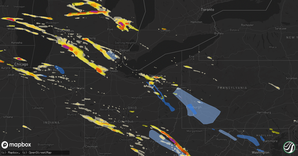
Hail Map on April 7, 2020
Get this storm
April 7 map
$229
one time, instant access
Download today. No call, no setup
Keep the $229
Bought the map and want the full workflow? Apply the entire $229 to a subscription within 7 days. None of it is wasted.
Every map, not just this one
This buys you this map. Subscription and you get every map we run, in the markets you choose from a few cities to whole states to nationwide. Plus real-time alerts the moment a storm fires.
Contact data
Name, contact info, occupancy, even credit band for addresses in the footprint. You go from where it hit to who to call.
Become the source they trust
Unlimited branding weather history reports on demand. You already have the documented answer ready for the property owner, and you are the one who showed up with it.
Property data and RoofTrace estimates
Pull up any address you have got, its value and the exact code rules for that jurisdiction, straight from One Click Code. Then RoofTrace estimates the squares, pitch, and roof value, priced the way you price.
States Impacted by Hail Map on April 7, 2020
Storm reports
Michigan
| Date | Description |
|---|---|
| 04/07/20206:55 PM CDT | . |
| 04/07/20206:28 PM CDT | Delayed report. Photo of large hail. |
| 04/07/20206:25 PM CDT | A local report indicates 1.75 inch wind near 3 ESE EDENVILLE |
| 04/07/20206:22 PM CDT | A local report indicates 1.00 inch wind near WALKER |
| 04/07/20205:30 PM CDT | A local report indicates 1.50 inch wind near 2 SW WHITEHALL |
| 04/07/20205:25 PM CDT | A local report indicates 1.00 inch wind near WHITEHALL |
| 04/07/20205:25 PM CDT | Corrects previous hail report from 1 ssw whitehall. Time estimated from radar. |
| 04/07/20205:15 PM CDT | A local report indicates 1.00 inch wind near BEAR LAKE |
| 04/07/20205:15 PM CDT | A local report indicates 1.00 inch wind near 1 ENE WILDWOOD |
| 04/07/20205:08 PM CDT | A local report indicates 1.00 inch wind near 1 ENE CADILLAC |
| 04/07/20205:00 PM CDT | A local report indicates 1.00 inch wind near ARCADIA |
| 04/07/20205:47 AM CDT | At 1046 PM EDT, a severe thunderstorm was located over Hudson, moving southeast at 50 mph. HAZARD...Half dollar size hail. SOURCE...Radar indicated. IMPACT...Damage to vehicles is expected. This severe thunderstorm will be near... Clayton around 1050 PM EDT. Morenci around 1055 PM EDT.Other locations impacted by this severe thunderstorm include Seneca,Manitou Beach-Devils Lake, Lime Creek, Munson, Ogden Center,Canandaigua, Palmyra, Sand Creek, Rome Center and Jasper. |
| 04/07/20205:44 AM CDT | At 1044 PM EDT, a severe thunderstorm was located 8 miles northeast of Pioneer, or 8 miles southwest of Hudson, moving southeast at 55 mph. HAZARD...60 mph wind gusts and quarter size hail. SOURCE...Radar indicated. IMPACT...Hail damage to vehicles is expected. Expect wind damage to roofs, siding, and trees. Locations impacted include... Napoleon, Wauseon, Archbold, Swanton, Delta, Hudson, West Unity, Pioneer, Fayette, Liberty Center, Pittsford, Ransom, Metamora, Lyons, Waldron, Texas, Prattville, Oakshade, Alvordton and Grelton.This includes Interstate 80 in Ohio between mile markers 19 and 48. |
| 04/07/20205:21 AM CDT | At 1021 PM EDT, a severe thunderstorm was located near Bristol, or near Elkhart, moving east at 30 mph. HAZARD...70 mph wind gusts and quarter size hail. SOURCE...Radar indicated. IMPACT...Hail damage to vehicles is expected. Expect considerable tree damage. Wind damage is also likely to mobile homes, roofs, and outbuildings. Locations impacted include... Elkhart, Dunlap, Middlebury, Bristol, Topeka, Shipshewana, Honeyville and Emma.This includes Interstate 80 in Indiana between mile markers 95 and104. |
| 04/07/20204:54 AM CDT | At 954 PM EDT, severe thunderstorms were located along a line extending from near Albion to 5 miles southwest of Homer, moving east at 50 mph. HAZARD...60 mph wind gusts and quarter size hail. SOURCE...Radar indicated. IMPACT...Hail damage to vehicles is expected. Expect wind damage to roofs, siding, and trees. Locations impacted include... Jackson... Vandercook Lake... Brooklyn... Grass Lake... Leoni... Spring Arbor... Napoleon... Sandstone... Norvell... Pulaski... Concord... Horton... Parma... Hanover... Oak Point... Sunset Beach... Michigan Center... |
| 04/07/20204:31 AM CDT | At 931 PM EDT, a severe thunderstorm was located near Midland, moving east at 60 mph. HAZARD...Ping pong ball size hail. SOURCE...Radar indicated. IMPACT...People and animals outdoors will be injured. Expect damage to roofs, siding, windows, and vehicles. This severe thunderstorm will be near... Freeland around 935 PM EDT. Auburn around 940 PM EDT. Zilwaukee around 945 PM EDT. Bay City and Kawkawlin around 950 PM EDT. Essexville and Munger around 955 PM EDT.Other locations impacted by this severe thunderstorm include Willard,Bay City State Recreation Area, Indiantown and Carrollton. |
| 04/07/20204:17 AM CDT | At 917 PM EDT, a severe thunderstorm was located near Manchester, moving southeast at 40 mph. HAZARD...60 mph wind gusts. SOURCE...Radar indicated. IMPACT...Expect damage to roofs, siding, and trees. This severe thunderstorm will be near... Manchester around 920 PM EDT.Other locations impacted by this severe thunderstorm includeBridgewater, Pittsfield Township, Pleasant Lake and Whittaker. |
| 04/07/20204:13 AM CDT | At 913 PM EDT, severe thunderstorms were located along a line extending from near Hastings to 7 miles north of Paw Paw, moving southeast at 40 mph. HAZARD...Golf ball size hail and 60 mph wind gusts. SOURCE...Radar indicated. IMPACT...People and animals outdoors will be injured. Expect hail damage to roofs, siding, windows, and vehicles. Expect wind damage to roofs, siding, and trees. Locations impacted include... Kalamazoo... Portage... Albion... Marshall... Westwood... Battle Creek... Vicksburg... Galesburg... Homer... Union City... Schoolcraft... Climax... Richland... Burlington... Brownlee Park... Comstock Northwest... Level Park-Oak Park... South Gull Lake... Alamo... Fulton... |
| 04/07/20204:12 AM CDT | At 911 PM EDT, a severe thunderstorm was located over Shepherd, or 7 miles southeast of Mount Pleasant, moving east at 60 mph. HAZARD...Quarter size hail. SOURCE...Radar indicated. IMPACT...Damage to vehicles is expected. This severe thunderstorm will be near... Oil City around 915 PM EDT. Midland around 935 PM EDT.Other locations impacted by this severe thunderstorm include Laporte,Porter Township, Gordonville and Poseyville. |
| 04/07/20204:05 AM CDT | At 904 PM EDT, a severe thunderstorm was located south of Mount Pleasant and west of Shepherd, moving east at 60 mph. HAZARD...Golf ball size hail. SOURCE...Radar indicated. IMPACT...People and animals outdoors will be injured. Expect damage to roofs, siding, windows, and vehicles. Locations impacted include... Shepherd... |
| 04/07/20203:59 AM CDT | At 858 PM EDT, severe thunderstorms were located along a line extending from 5 miles east of Lake Odessa to near Middleville to near Otsego, moving east at 60 mph. HAZARD...60 mph wind gusts and quarter size hail. SOURCE...Radar indicated. IMPACT...Hail damage to vehicles is expected. Expect wind damage to roofs, siding, and trees. Locations impacted include... Lansing... Charlotte... Hastings... Eaton Rapids... Waverly... Grand Ledge... Middleville... Potterville... Nashville... Bellevue... Edgemont Park... Orangeville... Irving... Assyria... Kalamo... Olivet... Brookfield... Dimondale... Vermontville... Woodland... |
| 04/07/20203:53 AM CDT | At 852 PM EDT, severe thunderstorms were located along a line extending from near Twin Lakes Area to near Hockaday to 8 miles southwest of Roscommon Township, moving southeast at 55 mph. HAZARD...60 mph wind gusts and quarter size hail. SOURCE...Radar indicated. IMPACT...Hail damage to vehicles is expected. Expect wind damage to roofs, siding, and trees. Severe thunderstorms will be near... West Branch and Bowmanville around 900 PM EDT. Alger and Skidway Lake around 910 PM EDT. Gladwin, Sterling and Hockaday around 915 PM EDT. Standish, Maple Ridge, Wooden Shoe Village and Winegars around 920 PM EDT. Omer around 925 PM EDT. Twining, Turner and Rhodes around 930 PM EDT. Au Gres around 935 PM EDT.Other locations impacted by these severe thunderstorms includePrescott. |
| 04/07/20203:41 AM CDT | At 840 PM EDT, severe thunderstorms were located along a line extending from near Peck to near Brown City to near Lum, moving southeast at 65 mph. HAZARD...Quarter size hail. SOURCE...Radar indicated. IMPACT...Damage to vehicles is expected. Severe thunderstorms will be near... Yale and Capac around 855 PM EDT. Lakeport, Armada and Emmett around 900 PM EDT. Richmond and Memphis around 905 PM EDT. Port Huron and Marysville around 910 PM EDT. St. Clair and Marine City around 920 PM EDT.Other locations impacted by these severe thunderstorms includeAnchorville, North Street, Adair, Lynn Township, Rattle Run,Goodells, Brockway, Smiths Creek, Fair Haven and Wadhams. |
| 04/07/20203:36 AM CDT | At 836 PM EDT, a severe thunderstorm was located near Morley, or 15 miles south of Big Rapids, moving east at 50 mph. HAZARD...Quarter size hail. SOURCE...Radar indicated. IMPACT...Damage to vehicles is expected. Locations impacted include... Howard City... Edmore... Lakeview... Morley... Canadian Lakes... Mcbride... Sylvester... Westville... Cedar Lake... Entrican... Amble... Six Lakes... Altona... Vestaburg... Blanchard... Wyman... Winn... |
| 04/07/20203:35 AM CDT | At 835 PM EDT, severe thunderstorms were located along a line extending from near Gregory to 5 miles southeast of Mason to near Leslie, moving southeast at 30 mph. HAZARD...Golf ball size hail and 60 mph wind gusts. SOURCE...Radar indicated. IMPACT...People and animals outdoors will be injured. Expect hail damage to roofs, siding, windows, and vehicles. Expect wind damage to roofs, siding, and trees. Locations impacted include... Jackson... Mason... Vandercook Lake... Leslie... Stockbridge... Brooklyn... Grass Lake... Leoni... Napoleon... Aurelius... Onondaga... Norvell... Bunker Hill... Dansville... Eden... Fitchburg... Oak Point... Topkins... Rives Junction... Sunset Beach... |
| 04/07/20203:29 AM CDT | At 829 PM EDT, severe thunderstorms were located along a line extending from Marlette to near North Branch, moving southeast at 55 mph. HAZARD...Quarter size hail. SOURCE...Radar indicated. IMPACT...Damage to vehicles is expected. Severe thunderstorms will be near... Brown City around 840 PM EDT. Peck and Melvin around 845 PM EDT.Other locations impacted by these severe thunderstorms include BirchBeach, Watertown, Lexington Heights, Roseburg, Amador, Juhl andValley Center. |
| 04/07/20203:26 AM CDT | At 825 PM EDT, a severe thunderstorm was located near Houghton Lake, moving east at 50 mph. HAZARD...60 mph wind gusts and quarter size hail. SOURCE...Radar indicated. IMPACT...Hail damage to vehicles is expected. Expect wind damage to roofs, siding, and trees. This severe thunderstorm will be near... Houghton Lake around 830 PM EDT. Prudenville, Roscommon Township and Roscommon County Airport around 835 PM EDT. Nester Township around 845 PM EDT. Twin Lakes Area around 850 PM EDT. |
| 04/07/20203:25 AM CDT | At 825 PM EDT, a severe thunderstorm was located near Stockbridge, or 12 miles southeast of Mason, moving southeast at 50 mph. HAZARD...60 mph wind gusts and half dollar size hail. SOURCE...Radar indicated. IMPACT...Hail damage to vehicles is expected. Expect wind damage to roofs, siding, and trees. This severe thunderstorm will be near... Gregory around 835 PM EDT. Chelsea and Pinckney around 840 PM EDT. Dexter and Hamburg around 850 PM EDT. Ann Arbor and Whitmore Lake around 855 PM EDT. Dixboro around 900 PM EDT. Ypsilanti and Salem around 905 PM EDT.Other locations impacted by this severe thunderstorm includePlainfield, Hudson Mills Metropark, Island Lake State RecreationArea, Delhi Mills, Barton Hills, Pinckney State Recreation Area,Hudson Mills, Parkers Corners, Lakeland and Lyndon Township. |
| 04/07/20203:19 AM CDT | At 819 PM EDT, severe thunderstorms were located along a line extending from near Mayville to near Millington, moving southeast at 60 mph. HAZARD...Quarter size hail. SOURCE...Radar indicated. IMPACT...Damage to vehicles is expected. Severe thunderstorms will be near... Clifford around 825 PM EDT. North Branch and Columbiaville around 830 PM EDT. Lapeer and Brown City around 840 PM EDT. Lum around 845 PM EDT. Imlay City and Dryden around 850 PM EDT. Almont around 855 PM EDT.Other locations impacted by these severe thunderstorms includeGoodland Township, East Dayton, Burnside, Attica, Kings Mill,Silverwood and Fostoria. |
| 04/07/20203:19 AM CDT | At 819 PM EDT, severe thunderstorms were located along a line extending from near Lowell to near Freeport, moving east at 35 mph. HAZARD...60 mph wind gusts and quarter size hail. SOURCE...Radar indicated. IMPACT...Hail damage to vehicles is expected. Expect wind damage to roofs, siding, and trees. Locations impacted include... Ionia... Portland... Lake Odessa... Saranac... Sebewa... Lyons... Muir... Mulliken... Pewamo... Clarksville... |
| 04/07/20203:16 AM CDT | At 816 PM EDT, severe thunderstorms were located along a line extending from near Beechwood to 11 miles west of Saugatuck, moving east at 45 mph. HAZARD...60 mph wind gusts and quarter size hail. SOURCE...Radar indicated. IMPACT...Hail damage to vehicles is expected. Expect wind damage to roofs, siding, and trees. Locations impacted include... Holland... Allegan... Plainwell... Wayland... Otsego... Fennville... Saugatuck... Martin... Saugatuck SP... Dorr... Ganges... Hamilton... Douglas... Hopkins... Burnips... Bradley... North Dorr... Castle Park... Pullman... Shelbyville... |
| 04/07/20203:12 AM CDT | At 812 PM EDT, severe thunderstorms were located along a line extending from near Sparta to near Walker to near Caledonia, moving east at 20 mph. HAZARD...60 mph wind gusts and quarter size hail. SOURCE...Radar indicated. IMPACT...Hail damage to vehicles is expected. Expect wind damage to roofs, siding, and trees. Locations impacted include... Grand Rapids... Lowell... Wyoming... Kentwood... Walker... East Grand Rapids... Rockford... Sparta... Caledonia... Forest Hills... Northview... Grandville... Ada... Grattan... Cedar Springs... Sand Lake... Cutlerville... Belmont... Alto... Alaska... |
| 04/07/20203:01 AM CDT | At 801 PM EDT, a severe thunderstorm was located near Edenville, or 11 miles northeast of Sanford, moving east at 65 mph. HAZARD...Half dollar size hail. SOURCE...Radar indicated. IMPACT...Damage to vehicles is expected. This severe thunderstorm will be near... Pinconning around 815 PM EDT.Other locations impacted by this severe thunderstorm include Crumpand Mount Forest. |
| 04/07/20202:54 AM CDT | At 753 PM EDT, a severe thunderstorm was located over Zilwaukee, or near Bay City, moving southeast at 60 mph. HAZARD...Quarter size hail. SOURCE...Radar indicated. IMPACT...Damage to vehicles is expected. This severe thunderstorm will remain over mainly rural areas of southeastern Bay and northeastern Saginaw Counties, including the following locations... Carrollton, Gera, Buena Vista Township, Arthur and Indiantown. |
| 04/07/20202:54 AM CDT | At 754 PM EDT, severe thunderstorms were located along a line extending from near Grand Ledge to near Potterville to 7 miles northeast of Nashville, moving southeast at 50 mph. HAZARD...60 mph wind gusts and quarter size hail. SOURCE...Radar indicated. IMPACT...Hail damage to vehicles is expected. Expect wind damage to roofs, siding, and trees. Locations impacted include... Lansing... Charlotte... Mason... Eaton Rapids... Waverly... Haslett... East Lansing... Grand Ledge... Williamston... Potterville... Leslie... Stockbridge... Edgemont Park... Aurelius... Onondaga... Bunker Hill... Brookfield... Webberville... Dimondale... Dansville... |
| 04/07/20202:53 AM CDT | At 752 PM EDT, a severe thunderstorm was located near Edenville, or near Coleman, moving east at 65 mph. HAZARD...Ping pong ball size hail. SOURCE...Radar indicated. IMPACT...People and animals outdoors will be injured. Expect damage to roofs, siding, windows, and vehicles. This severe thunderstorm will be near... Rhodes around 805 PM EDT. |
| 04/07/20202:48 AM CDT | At 748 PM EDT, a severe thunderstorm was located near Manton, or 14 miles north of Cadillac, moving east at 55 mph. HAZARD...Quarter size hail. SOURCE...Radar indicated. IMPACT...Damage to vehicles is expected. This severe thunderstorm will be near... Morey and Jennings around 800 PM EDT. Lake City around 805 PM EDT. Falmouth around 810 PM EDT. Moddersville around 820 PM EDT.Other locations impacted by this severe thunderstorm includeStittsville and Merritt. |
| 04/07/20202:42 AM CDT | At 742 PM EDT, severe thunderstorms were located along a line extending from Lake Isabella to near Mecosta, moving southeast at 45 mph. HAZARD...60 mph wind gusts and quarter size hail. SOURCE...Radar indicated. IMPACT...Hail damage to vehicles is expected. Expect wind damage to roofs, siding, and trees. Locations impacted include... Mount Pleasant... Shepherd... Mecosta... Winn... Blanchard... |
| 04/07/20202:42 AM CDT | At 742 PM EDT, severe thunderstorms were located along a line extending from 10 miles north of Quanicassee to 6 miles northeast of Essexville to Auburn, moving east at 60 mph. HAZARD...Half dollar size hail. SOURCE...Radar indicated. IMPACT...Damage to vehicles is expected. Severe thunderstorms will be near... Quanicassee around 750 PM EDT. Akron and Unionville around 755 PM EDT. Caro, Cass City, Reese and Gagetown around 805 PM EDT. Vassar and Fairgrove around 810 PM EDT. Mayville around 825 PM EDT. Kingston around 830 PM EDT.Other locations impacted by these severe thunderstorms include EastDayton, Deford, Colling, Wilmot, Colwood, Wisner, Ellington, Gilford,Watrousville and Silverwood. |
| 04/07/20202:17 AM CDT | At 717 PM EDT, severe thunderstorms were located along a line extending from 6 miles southwest of Roosevelt Park to 32 miles west of Grand Haven, moving east at 35 mph. HAZARD...60 mph wind gusts and quarter size hail. SOURCE...Radar indicated. IMPACT...Hail damage to vehicles is expected. Expect wind damage to roofs, siding, and trees. Locations impacted include... Holland... Grand Haven... Hudsonville... Zeeland... Coopersville... Ferrysburg... Fruitport... Beechwood... Jenison... Norton Shores... Spring Lake... Wright... Lamont... Drenthe... Grand Valley... Bauer... Jamestown... Allendale... Olive Center... Nunica... |
| 04/07/20202:14 AM CDT | At 713 PM EDT, a severe thunderstorm was located 7 miles south of Evart, moving east at 60 mph. HAZARD...60 mph wind gusts and quarter size hail. SOURCE...Radar indicated. IMPACT...Hail damage to vehicles is expected. Expect wind damage to roofs, siding, and trees. Locations impacted include... Mount Pleasant... Big Rapids... Clare... Reed City... Farwell... Rosebush... Barryton... Lake Isabella... Lake... Paris... Hersey... Brinton... Rodney... Gibos Corners... Loomis... Delwin... Chippewa Lake... Beal City... Weidman... |
| 04/07/20202:13 AM CDT | At 713 PM EDT, severe thunderstorms were located along a line extending from near Belding to near Lowell, moving southeast at 65 mph. HAZARD...60 mph wind gusts and quarter size hail. SOURCE...Radar indicated. IMPACT...Hail damage to vehicles is expected. Expect wind damage to roofs, siding, and trees. Locations impacted include... Ionia... Belding... Portland... Lake Odessa... Saranac... Orleans... Sebewa... Lyons... Muir... Mulliken... Pewamo... Hubbardston... Clarksville... Palo... Smyrna... |
| 04/07/20202:10 AM CDT | At 710 PM EDT, severe thunderstorms were located along a line extending from near Vogel Center to near Lucas, moving east at 55 mph. HAZARD...60 mph wind gusts and quarter size hail. SOURCE...Radar indicated. IMPACT...Hail damage to vehicles is expected. Expect wind damage to roofs, siding, and trees. Locations impacted include... Marion... Highland... Temple... Pisgah Heights... Dighton... Ina... Leota... Park Lake... |
| 04/07/20202:06 AM CDT | At 705 PM EDT, severe thunderstorms were located along a line extending from Winegars to near Beaverton to near Clare, moving southeast at 60 mph. HAZARD...Quarter size hail. SOURCE...Radar indicated. IMPACT...Damage to vehicles is expected. Severe thunderstorms will be near... Bentley around 715 PM EDT. Pinconning, Sanford and Edenville around 725 PM EDT. Auburn around 740 PM EDT. Kawkawlin and Linwood around 745 PM EDT. Bay City and Essexville around 750 PM EDT.Other locations impacted by these severe thunderstorms include MountForest, Averill, Bombay, Crump, Willard, Hope, Bay City StateRecreation Area and North Bradley. |
| 04/07/20201:54 AM CDT | At 654 PM EDT, a severe thunderstorm was located over Mitchell State Park, or over Cadillac, moving southeast at 35 mph. HAZARD...Quarter size hail. SOURCE...Radar indicated. IMPACT...Damage to vehicles is expected. This severe thunderstorm will be near... Lucas around 705 PM EDT. Mcbain around 710 PM EDT. Falmouth around 720 PM EDT. Vogel Center around 725 PM EDT.Other locations impacted by this severe thunderstorm include Merritt. |
| 04/07/20201:49 AM CDT | At 649 PM EDT, severe thunderstorms were located along a line extending from Skeels to 9 miles west of Gladwin to 7 miles east of Evart, moving east at 55 mph. HAZARD...60 mph wind gusts and quarter size hail. SOURCE...Radar indicated. IMPACT...Hail damage to vehicles is expected. Expect wind damage to roofs, siding, and trees. Severe thunderstorms will be near... Gladwin and Skeels around 655 PM EDT. Beaverton and Hockaday around 700 PM EDT. Wooden Shoe Village and Winegars around 705 PM EDT. Rhodes around 715 PM EDT. |
| 04/07/20201:20 AM CDT | At 620 PM EDT, a severe thunderstorm was located near Kaleva, or 12 miles south of Thompsonville, moving southeast at 50 mph. HAZARD...Half dollar size hail. SOURCE...Radar indicated. IMPACT...Damage to vehicles is expected. This severe thunderstorm will be near... Harrietta and Yuma around 630 PM EDT. Hoxeyville around 635 PM EDT. Boon around 640 PM EDT. Mitchell State Park around 650 PM EDT. |
| 04/07/20201:05 AM CDT | At 604 PM EDT, severe thunderstorms were located along a line extending from near Jennings to near Mitchell State Park to near Hoxeyville, moving southeast at 55 mph. HAZARD...60 mph wind gusts and quarter size hail. SOURCE...Radar indicated. IMPACT...Hail damage to vehicles is expected. Expect wind damage to roofs, siding, and trees. Locations impacted include... Clare... Evart... Marion... Farwell... Highland... Lake... Le Roy... Tustin... Gibos Corners... Lake George... Ashton... Sears... Temple... Pisgah Heights... Avondale... Dighton... Ina... Leota... Park Lake... Stambaugh Corner... |
| 04/07/202012:52 AM CDT | At 552 PM EDT, a severe thunderstorm was located 21 miles west of Montague, or 29 miles northwest of Muskegon, moving east at 40 mph. HAZARD...60 mph wind gusts and quarter size hail. SOURCE...Radar indicated. IMPACT...Hail damage to vehicles is expected. Expect wind damage to roofs, siding, and trees. Locations impacted include... Muskegon... Newaygo... North Muskegon... Whitehall... Montague... Lakewood Club... Grant... Dalton... Holton... Bridgeton... Casnovia... Brunswick... Wolf Lake... Twin Lake... Slocum... Bailey... |
| 04/07/202012:51 AM CDT | At 550 PM EDT, a severe thunderstorm was located near Arcadia, or 10 miles southwest of Frankfort, moving southeast at 55 mph. HAZARD...60 mph wind gusts and quarter size hail. SOURCE...Radar indicated. IMPACT...Hail damage to vehicles is expected. Expect wind damage to roofs, siding, and trees. This severe thunderstorm will be near... Pierport around 555 PM EDT. Onekama, Bear Lake and Wildwood around 600 PM EDT. Norwalk around 605 PM EDT. Kaleva, Copemish and Brethren around 610 PM EDT.Other locations impacted by this severe thunderstorm include BlaineTownship, Star Crossing and Pere Marquette State Forest. |
| 04/07/202012:37 AM CDT | At 535 PM EDT, severe thunderstorms were located along a line extending from near Mesick to near Brethren to near Norwalk, moving east at 65 mph. HAZARD...60 mph wind gusts and quarter size hail. SOURCE...Radar indicated. Hail up to three-quarters of an inch has been reported with this storm. IMPACT...Hail damage to vehicles is expected. Expect wind damage to roofs, siding, and trees. Severe thunderstorms will be near... Sherman, Mesick and Yuma around 540 PM EDT. Harrietta around 545 PM EDT. Boon and Meauwataka around 550 PM EDT. Cadillac and Manton around 555 PM EDT. Mitchell State Park around 605 PM EDT. |
| 04/07/202012:12 AM CDT | At 512 PM EDT, a severe thunderstorm was located near Pierport, or 13 miles southwest of Frankfort, moving east at 55 mph. HAZARD...Quarter size hail. SOURCE...Radar indicated. IMPACT...Damage to vehicles is expected. Locations impacted include... Arcadia, Kaleva, Onekama, Copemish, Brethren, Norwalk, Pierport, Orchard Beach State Park and Pere Marquette State Forest. |
| 04/06/20209:58 PM CDT | Picture shared on social media |
| 04/06/20209:40 PM CDT | Hillsdale county em reported trees and power lines down. Time estimated from radar. |
| 04/06/20209:18 PM CDT | . |
| 04/06/20209:02 PM CDT | Golf ball hail near intersection of 14th and south hampton |
| 04/06/20208:54 PM CDT | A local report indicates 1.00 inch wind near 5 ENE PINE CREEK |
| 04/06/20208:50 PM CDT | A local report indicates 1.00 inch wind near 1 SE MARSHALL |
| 04/06/20208:42 PM CDT | Near the intersection of salzburg and s saginaw road. |
| 04/06/20208:40 PM CDT | . |
| 04/06/20208:39 PM CDT | A local report indicates 1.50 inch wind near 3 S BROWNLEE PARK |
| 04/06/20208:38 PM CDT | Report from mping: quarter |
| 04/06/20208:38 PM CDT | Mostly nickel size hail with some quarter size hail |
| 04/06/20208:37 PM CDT | Half dollar to ping pong ball size hail. |
| 04/06/20208:36 PM CDT | A local report indicates 1.00 inch wind near MIDLAND |
| 04/06/20208:36 PM CDT | A local report indicates 1.00 inch wind near 2 SSE SPRINGFIELD |
| 04/06/20208:29 PM CDT | Photo shared via social media near the intersection of east miller road and south woodcock road. |
| 04/06/20208:29 PM CDT | Near the intersection of w stewart road and s 8 mile road. |
| 04/06/20208:29 PM CDT | 1.75 to 2.00 inch hail 2 miles south of m-20 on s meridian road |
| 04/06/20208:28 PM CDT | A local report indicates 1.25 inch wind near 2 S MOUNT PLEASANT |
| 04/06/20208:27 PM CDT | Report from mping: golf ball |
| 04/06/20208:26 PM CDT | A local report indicates 2.00 inch wind near PLAINWELL |
| 04/06/20208:25 PM CDT | Delayed report. Photo via social media. |
| 04/06/20208:25 PM CDT | A local report indicates 1.50 inch wind near 6 W ANN ARBOR |
| 04/06/20208:23 PM CDT | Report from mping: half dollar |
| 04/06/20208:21 PM CDT | Report from mping: half dollar |
| 04/06/20208:20 PM CDT | A local report indicates 1.00 inch wind near 6 W ANN ARBOR |
| 04/06/20208:17 PM CDT | Delayed report. Two photos from oshtemo twp via social media. |
| 04/06/20208:17 PM CDT | Report from mping: quarter |
| 04/06/20208:14 PM CDT | Report along atkins road. |
| 04/06/20208:13 PM CDT | Pictured shared on social media with time estimated via radar |
| 04/06/20208:12 PM CDT | Report from mping: quarter |
| 04/06/20208:11 PM CDT | Report from mping: quarter |
| 04/06/20208:10 PM CDT | A local report indicates 2.00 inch wind near PLAINWELL |
| 04/06/20208:09 PM CDT | Report from mping: quarter |
| 04/06/20208:08 PM CDT | A local report indicates 1.00 inch wind near AVOCA |
| 04/06/20208:03 PM CDT | Tree down across plains road. |
| 04/06/20208:00 PM CDT | Time estimated from radar. |
| 04/06/20207:55 PM CDT | A local report indicates 1.75 inch wind near 3 W OTSEGO |
| 04/06/20207:52 PM CDT | A local report indicates 1.00 inch wind near YALE |
| 04/06/20207:50 PM CDT | Time estimated on radar |
| 04/06/20207:50 PM CDT | Quarter to golf ball size hail |
| 04/06/20207:49 PM CDT | Delayed report. |
| 04/06/20207:47 PM CDT | Delayed report. Photos of golf ball size hail. Possibly hen egg size. |
| 04/06/20207:47 PM CDT | Report from mping: quarter |
| 04/06/20207:46 PM CDT | Ping pong ball to golf ball size hail |
| 04/06/20207:45 PM CDT | A local report indicates 1.00 inch wind near DORR |
| 04/06/20207:40 PM CDT | Delayed report. Photos of golf ball size hail. Possibly hen egg size. |
| 04/06/20207:39 PM CDT | Report along slater road. |
| 04/06/20207:37 PM CDT | 1.75 to 2.00 inch hail |
| 04/06/20207:36 PM CDT | Time estimated from radar. |
| 04/06/20207:36 PM CDT | A local report indicates 1.25 inch wind near BROWN CITY |
| 04/06/20207:35 PM CDT | Hail covered the ground and dented the roof of a shed. |
| 04/06/20207:32 PM CDT | Time estimated based on radar. |
| 04/06/20207:30 PM CDT | Time estimated. |
| 04/06/20207:29 PM CDT | Quarter to ping pong ball size hail. Time based on radar. |
| 04/06/20207:27 PM CDT | A local report indicates 1.00 inch wind near 1 SSE HOLLAND |
| 04/06/20207:26 PM CDT | A local report indicates 1.00 inch wind near 2 SSW COMSTOCK PARK |
| 04/06/20207:25 PM CDT | A local report indicates 1.00 inch wind near 2 NE HOLLAND |
| 04/06/20207:20 PM CDT | A local report indicates 1.75 inch wind near GRAND LEDGE |
| 04/06/20207:03 PM CDT | Quarter to half dollar size hail from numerous sources in manton. |
| 04/06/20207:00 PM CDT | A local report indicates 1.00 inch wind near 4 SSW GRAND LEDGE |
Indiana
| Date | Description |
|---|---|
| 04/07/20205:45 AM CDT | At 1045 PM EDT, severe thunderstorms were located along a line extending from 6 miles northeast of Lagrange to Topeka, moving east at 45 mph. HAZARD...60 mph wind gusts and quarter size hail. SOURCE...Radar indicated. IMPACT...Hail damage to vehicles is expected. Expect wind damage to roofs, siding, and trees. Locations impacted include... Auburn, Kendallville, Angola, Lagrange, Waterloo, Hamilton, Rome City, Topeka, Wolcottville, Ashley, Hudson, Corunna, Flint, Fairfield Center, Lake Gauge, Brushy Prairie, Pleasant Lake, Hamilton Lake, Golden Lake and Big Long Lake.This includes the following highways... Interstate 69 in Indiana between mile markers 331 and 353. Interstate 80 in Indiana between mile markers 151 and 155. |
| 04/07/20205:41 AM CDT | At 1040 PM EDT/940 PM CDT/, a severe thunderstorm was located over Valparaiso, moving east at 45 mph. Nickel to quarter size hail has been reported in Valparaiso HAZARD...60 mph wind gusts and quarter size hail. SOURCE...Radar indicated. IMPACT...Hail damage to vehicles is expected. Expect wind damage to roofs, siding, and trees. Locations impacted include... Westville, Walkerton, Kingsford Heights, Wanatah, Hamlet, Koontz Lake, Oak Grove, Hanna, Kingsbury, Thomaston, Teegarden, Pinhook, South Center, Salem Heights, South Wanatah, Tracy, Tyner, Union Mills, Donaldson and Haskell. |
| 04/07/20205:08 AM CDT | At 1008 PM EDT, a severe thunderstorm was located near Edwardsburg, or near Granger, moving east at 30 mph. HAZARD...60 mph wind gusts and quarter size hail. SOURCE...Radar indicated. IMPACT...Hail damage to vehicles is expected. Expect wind damage to roofs, siding, and trees. Locations impacted include... Elkhart, Niles, Simonton Lake, Constantine, Bristol, Edwardsburg, Union, Mottville, Dailey, Barron Lake, Calvin Center, Adamsville, Juno Lake, Shavehead Lake and Eagle Lake.This includes Interstate 80 in Indiana between mile markers 89 and105. |
| 04/07/20204:36 AM CDT | At 935 PM EDT/835 PM CDT/, severe thunderstorms were located along a line extending from near Three Oaks to near Trail Creek, moving east at 35 mph. HAZARD...60 mph wind gusts and quarter size hail. SOURCE...Radar indicated. IMPACT...Hail damage to vehicles is expected. Expect wind damage to roofs, siding, and trees. Locations impacted include... South Bend, Michigan City, La Porte, Georgetown, Trail Creek, Granger, New Carlisle, Three Oaks, Roseland, Bertrand, Dayton, Galien, Indian Village, Byron, Hudson Lake, Waterford, Chain-o-lakes, Rolling Prarie, Crumstown and Hesston.This includes the following highways... Interstate 80 in Indiana between mile markers 45 and 79. Interstate 94 in Indiana between mile markers 34 and 41. |
| 04/07/20204:29 AM CDT | At 928 PM EDT, a severe thunderstorm was located near Bridgman, or 10 miles northwest of Buchanan, moving east at 30 mph. At 928 PM EDT...hail to the size of dimes was reported in Sawyer. HAZARD...Ping pong ball size hail and 60 mph wind gusts. SOURCE...Radar indicated. IMPACT...People and animals outdoors will be injured. Expect hail damage to roofs, siding, windows, and vehicles. Expect wind damage to roofs, siding, and trees. Locations impacted include... Niles, Buchanan, Bridgman, Shorewood-Tower Hill, Shorewood-Tower Hills-Harbert, Pokagon, Glendora, New Troy, Harbert, Dailey, Barron Lake, Sumnerville and Sawyer.This includes Interstate 94 in Michigan between mile markers 11 and16. |
| 04/07/20203:19 AM CDT | At 819 PM CDT, a severe thunderstorm was located over Hobart, moving east at 35 mph. HAZARD...Quarter size hail. SOURCE...Radar indicated. IMPACT...Damage to vehicles is expected. Locations impacted include... Gary, Portage, Merrillville, Valparaiso, Schererville, Hobart, Griffith, Chesterton, Lake Station, Porter, Burns Harbor, South Haven, Lincoln Hills, Wheeler, New Chicago and Kvpz.Including the following interstates... Indiana I-80 between mile markers 6 and 16. Indiana I-90 between mile markers 17 and 37. Indiana I-94 between mile markers 16 and 17. Indiana I-65 between mile markers 253 and 261.This includes...Indiana University Northwest, Valparaiso University, and Porter County Fairgrounds. |
| 04/06/20209:40 PM CDT | Two to three foot diameter tree down across road along with power lines down. Reported at 58152 county road 33... Middlebury... In. |
| 04/06/20209:35 PM CDT | Relayed via social media and time estimated by radar. |
| 04/06/20209:35 PM CDT | Power lines down. Reported at 58670 county road 29 goshen... In. |
| 04/06/20209:35 PM CDT | Public report sent via mping. |
| 04/06/20209:07 PM CDT | Time estimated via radar. |
| 04/06/20209:05 PM CDT | Time estimated via radar. |
| 04/06/20209:03 PM CDT | A local report indicates 1.00 inch wind near 1 NW PORTAGE |
| 04/06/20208:30 PM CDT | Time estimated via radar. |
North Carolina
| Date | Description |
|---|---|
| 04/07/20202:00 PM CDT | 1 inch hail... Partially covering the ground... In the lake gaston area. |
| 04/07/20201:46 PM CDT | Trees uprooted or snapped; roof blown off. Time estimated via radar. |
| 04/07/202012:35 AM CDT | At 535 PM EDT, a severe thunderstorm was located 10 miles north of Spartanburg, or near Boiling Springs SC, moving east at 30 mph. HAZARD...60 mph wind gusts and quarter size hail. SOURCE...Radar indicated. IMPACT...Minor hail damage to vehicles is expected. Expect wind damage to trees and power lines. Locations impacted include... Boiling Springs SC, Cowpens, Mayo, Chesnee, Cowpens National Battlefield, Lake Bowen, Fingerville and Inman. |
| 04/06/202011:27 PM CDT | At 427 PM EDT, a severe thunderstorm was located near Winton, or near Chowan University, moving east at 25 mph. HAZARD...60 mph wind gusts and quarter size hail. SOURCE...Radar indicated. IMPACT...Minor damage to vehicles is possible. Expect wind damage to trees and powerlines. This severe thunderstorm will be near, Ahoskie, Winton and Cofield around 440 PM EDT. Gatesville and Harrellsville around 500 PM EDT.Other locations impacted by this severe thunderstorm include Tunis,Eure, Menola, Newsome Store, Chowan Beach, Mapleton, Trap, Union, OakVilla and Saint John. |
| 04/06/202010:34 PM CDT | At 334 PM EDT, a severe thunderstorm was located near Claresville, or 8 miles east of Dahlia, moving east at 30 mph. HAZARD...60 mph wind gusts and quarter size hail. SOURCE...Radar indicated. IMPACT...Minor damage to vehicles is possible. Expect wind damage to trees and powerlines. This severe thunderstorm will be near, Boykins around 355 PM EDT. Newsoms around 400 PM EDT. Murfreesboro and Chowan University around 410 PM EDT. Como around 415 PM EDT.Other locations impacted by this severe thunderstorm include AdamsGrove, Pendleton, Mapleton, Bryants Corner, Riddicksville, Sunbeam,Oak Villa, Severn, Margarettsville and Bartonsville. |
| 04/06/202010:06 PM CDT | At 306 PM EDT, a severe thunderstorm was located near Redoak, moving southeast at 25 mph. HAZARD...60 mph wind gusts and quarter size hail. SOURCE...Radar indicated. IMPACT...Minor damage to vehicles is possible. Expect wind damage to trees and powerlines. This severe thunderstorm will be near, Clarksville around 315 PM EDT. Boydton around 335 PM EDT.Other locations impacted by this severe thunderstorm include SpanishGrove, Beechwood, John H Kerr Dam, Finchley, Skipwith, Rogers Corner,Richardson, Bracey, Keats and Eppes Fork. |
| 04/06/20209:53 PM CDT | At 252 PM EDT, a severe thunderstorm was located near Ebony, or 10 miles northeast of Warrenton, moving east at 30 mph. HAZARD...60 mph wind gusts and quarter size hail. SOURCE...Radar indicated. IMPACT...Hail damage to vehicles is expected. Expect wind damage to roofs, siding, and trees. Locations impacted include... Roanoke Rapids, Halifax, Littleton, Weldon, Macon, South Weldon, Airlie, Roanoke Rapids Lake, Rosemary and Lake Gaston. |
| 04/06/20209:27 PM CDT | At 226 PM EDT, a severe thunderstorm was located near Alberta, or 7 miles northwest of Lawrenceville, moving southeast at 25 mph. HAZARD...60 mph wind gusts and quarter size hail. SOURCE...Radar indicated. IMPACT...Minor damage to vehicles is possible. Expect wind damage to trees and powerlines. This severe thunderstorm will be near, Alberta around 230 PM EDT. Lawrenceville around 245 PM EDT. Brunswick around 255 PM EDT.Other locations impacted by this severe thunderstorm includeDanieltown, Ante, Cochran, Triplet, Edgerton, Dolphin, White Plains,Valentines, Meredithville and Prices Mill. |
Wisconsin
| Date | Description |
|---|---|
| 04/07/20206:25 PM CDT | Corrects previous hail report from 7 s monroe. Delayed report: nws employee observed 1.5 to 1.75 inch hail around the intersection of hgwy-69 and hgwy-26 along the wi/i |
| 04/07/20206:19 PM CDT | Delayed report: large hail around 2 to 2.5 inches |
| 04/07/20206:09 PM CDT | Relayed from social. |
| 04/07/20206:07 PM CDT | Relayed from social media. |
| 04/07/20206:04 PM CDT | A local report indicates 3.00 inch wind near 4 SE BROWNTOWN |
| 04/07/20205:59 PM CDT | Severe thunderstorm is still ongoing. |
| 04/07/20205:58 PM CDT | Relayed from social media. |
| 04/07/20205:54 PM CDT | A local report indicates 1.75 inch wind near SOUTH WAYNE |
| 04/07/20205:36 PM CDT | Delayed report. Facebook report. |
| 04/07/20205:30 PM CDT | Relayed from social media. |
| 04/07/20205:28 PM CDT | Relayed by wtmj. |
| 04/07/20205:26 PM CDT | Delayed report. Some squad car damage due to 2 inch diameter hail. |
| 04/07/20205:19 PM CDT | A local report indicates 1.00 inch wind near MENOMONEE FALLS |
| 04/07/20205:14 PM CDT | Delayed report: nickel to quarter sized hail observed on a farm on county road f northeast of darlington. |
| 04/07/20205:01 PM CDT | A local report indicates 1.00 inch wind near 5 S BELMONT |
| 04/07/20204:47 PM CDT | A few stones up to quarter size. |
| 04/07/20204:22 PM CDT | A local report indicates 1.50 inch wind near 1 NE GRAFTON |
| 04/07/20204:16 PM CDT | Found one hailstone measuring 2.5 inches... Most were golf ball size. |
| 04/07/20204:15 PM CDT | A local report indicates 1.00 inch wind near 2 E GRAFTON |
| 04/07/20204:14 PM CDT | A local report indicates 2.00 inch wind near GRAFTON |
| 04/07/20204:14 PM CDT | Report from mping: quarter |
| 04/07/20204:11 PM CDT | Report from mping: half dollar |
| 04/07/20204:10 PM CDT | Report from april 7th... 2020 storm. |
| 04/07/20204:08 PM CDT | A local report indicates 1.75 inch wind near CEDARBURG |
| 04/07/20204:05 PM CDT | A local report indicates 1.00 inch wind near CRIVITZ |
| 04/07/20203:59 PM CDT | Corrects time on previous hail report from 4 e jackson. Found one hailstone measuring 2.5 inches... Most were golf ball size. |
| 04/07/20203:52 PM CDT | Relayed via wtmj. |
| 04/07/20203:52 PM CDT | A local report indicates 1.75 inch wind near JACKSON |
| 04/07/20203:41 PM CDT | A local report indicates 1.00 inch wind near ALLENTON |
| 04/07/20203:15 PM CDT | Report via social media. |
| 04/07/20202:43 PM CDT | Covering roads. |
| 04/07/202010:21 AM CDT | A local report indicates 1.00 inch wind near 2 N WESTBORO |
| 04/07/202010:15 AM CDT | Relayed via broadcast media. |
| 04/07/20209:30 AM CDT | Photo from twitter and relayed by wqow-tv. Measured based on photo with quarter. Hail lasted six minutes. Near ladysmith airport and dairyland reservoir. Other tweets f |
| 04/07/20209:24 AM CDT | Hailed for several minutes. |
| 04/07/20208:35 AM CDT | Mostly peas... But a few quarters mixed in. |
| 04/07/20208:24 AM CDT | A local report indicates 1.00 inch wind near 1 W HERTEL |
| 04/07/20205:17 AM CDT | At 1017 AM CDT, a severe thunderstorm was located over Westboro, or 17 miles north of Medford, moving east at 50 mph. HAZARD...Ping pong ball size hail. SOURCE...Radar indicated. IMPACT...People and animals outdoors will be injured. Expect damage to roofs, siding, windows, and vehicles. This severe thunderstorm will be near... New Wood Wildlife Area around 1040 AM CDT. Birch Trails Girl Scout Camp around 1050 AM CDT. Merrill and Council Grounds State Park around 1055 AM CDT. Dutch Corners around 1100 AM CDT.Other locations impacted by this severe thunderstorm include Gleason,Dudley, Bill Cross Rapids Wildlife Area, Otis, Bloomville, Doeringand Irma. |
| 04/07/20204:43 AM CDT | At 942 AM CDT, a severe thunderstorm was located near Hawkins, or 17 miles east of Ladysmith, moving southeast at 60 mph. HAZARD...Ping pong ball size hail. SOURCE...Radar indicated. IMPACT...People and animals outdoors will be injured. Expect damage to roofs, siding, windows, and vehicles. Locations impacted include... Rib Lake, Chelsea, Westboro, Camp Forest Spring and Wood Lake. |
| 04/07/20204:39 AM CDT | At 939 AM CDT, a severe thunderstorm was located 8 miles west of Hawkins, or 12 miles northeast of Ladysmith, moving east at 50 mph. HAZARD...Golf ball size hail and 60 mph wind gusts. SOURCE...Radar indicated. IMPACT...People and animals outdoors will be injured. Expect hail damage to roofs, siding, windows, and vehicles. Expect wind damage to roofs, siding, and trees. Locations impacted include... Ogema, Prentice, Spirit, Catawba, and Kennan. |
| 04/07/20204:13 AM CDT | At 913 AM CDT, a severe thunderstorm was located near Exeland, or 15 miles northwest of Ladysmith, moving east at 55 mph. HAZARD...Quarter size hail. SOURCE...Radar indicated. IMPACT...Damage to vehicles is expected. Locations impacted include... Ladysmith, Hawkins, Tony, Glen Flora, Ingram and Rusk County Airport. |
| 04/07/20203:30 AM CDT | At 829 AM CDT, a severe thunderstorm was located near Spooner, moving east at 60 mph. HAZARD...60 mph wind gusts and quarter size hail. SOURCE...Radar indicated. IMPACT...Hail damage to vehicles is expected. Expect wind damage to roofs, siding, and trees. Locations impacted include... Spooner, Shell Lake, Trego, Stone Lake, Birchwood, Radisson, Exeland, Couderay, Edgewater, Sarona, Reserve, Spooner Lake, Lac Courte Oreilles Reservation, Deer Lake, Little Sissabagama Lake, Sissabagama Lake, Angus, and Lac Courte Oreilles. |
| 04/07/20201:16 AM CDT | At 616 PM CDT, a severe thunderstorm was located near Monroe, moving east at 40 mph. This is a very dangerous storm. HAZARD...Baseball size hail. SOURCE...Radar indicated. IMPACT...People and animals outdoors will be severely injured. Expect shattered windows, extensive damage to roofs, siding, and vehicles. Locations impacted include... Brodhead and Juda. |
| 04/07/202012:55 AM CDT | At 555 PM CDT, a severe thunderstorm was located near Apple River, or 15 miles east of Galena, moving east at 60 mph. HAZARD...60 mph wind gusts and quarter size hail. SOURCE...Radar indicated. IMPACT...Hail damage to vehicles is expected. Expect wind damage to roofs, siding, and trees. Locations impacted include... Freeport, Lena, Stockton, Warren, Cedarville, Davis, Woodbine, Dakota, Scales Mound, Apple River, Winslow, Rock City, Ridott, Nora, Schapville, Buena Vista, Rock Grove, Oneco, Guilford and Orangeville. |
| 04/07/202012:40 AM CDT | At 539 PM CDT, a severe thunderstorm was located near Warren, or 10 miles southeast of Darlington, moving east at 50 mph. HAZARD...60 mph wind gusts and quarter size hail. SOURCE...Radar indicated. IMPACT...Hail damage to vehicles is expected. Expect wind damage to roofs, siding, and trees. Locations impacted include... Monroe, Brodhead, Somers, Wiota, South Wayne, Browntown, Gratiot, Juda and Woodford. |
| 04/07/202012:26 AM CDT | At 526 PM CDT, a severe thunderstorm was located over northern Milwaukee, moving east at 45 mph. HAZARD...Quarter size hail. SOURCE...Radar indicated. IMPACT...Damage to vehicles is expected. Locations impacted include... Northern Milwaukee, Wauwatosa, Whitefish Bay, Brown Deer, Fox Point, Bayside, River Hills, Shorewood and UW-Milwaukee. |
| 04/07/202012:06 AM CDT | At 506 PM CDT, severe thunderstorms were located along a line extending from Belmont to near Shullsburg, moving east at 55 mph. HAZARD...60 mph wind gusts and quarter size hail. SOURCE...Radar indicated. IMPACT...Hail damage to vehicles is expected. Expect wind damage to roofs, siding, and trees. Locations impacted include... Darlington, Shullsburg, Belmont, Benton, Argyle, Blanchardville, Somers, Wiota, New Diggings, South Wayne, Lamont, Gratiot, Platte Mounds, Lead Mine, Yellowstone Lake St Park, Leslie and Woodford. |
| 04/06/202011:18 PM CDT | At 417 PM CDT, a severe thunderstorm was located 7 miles north of Menominee, moving east at 50 mph. HAZARD...Quarter size hail. SOURCE...At 405 CDT, a trained spotter reported 1 inch hail in Crivitz. IMPACT...Damage to vehicles is expected. Locations impacted include... Menominee, Wallace, Carbondale and Birch Creek. |
| 04/06/202011:06 PM CDT | At 405 PM CDT, a severe thunderstorm was located near Cedarburg, moving east at 40 mph. HAZARD...Golf ball size hail and 60 mph wind gusts. SOURCE...Radar indicated. IMPACT...People and animals outdoors will be injured. Expect hail damage to roofs, siding, windows, and vehicles. Expect wind damage to roofs, siding, and trees. Locations impacted include... Mequon, Grafton, Cedarburg, Port Washington, Saukville, Thiensville and Newburg.People attending Outdoor Testing at Aurora in Grafton, and OutdoorTesting at Ascension in Mequon should seek safe shelter immediately! |
| 04/06/202010:40 PM CDT | At 340 PM CDT, a severe thunderstorm was located near Slinger, moving east at 50 mph. HAZARD...60 mph wind gusts and quarter size hail. SOURCE...Radar indicated. IMPACT...Hail damage to vehicles is expected. Expect wind damage to roofs, siding, and trees. Locations impacted include... West Bend, Mequon, Hartford, Grafton, Cedarburg, Port Washington, Jackson, Slinger, Saukville, Fredonia, Newburg, Richfield, Addison, Nenno, Waubeka, Holy Hill, Allenton, Saint Lawrence and Kohlsville.People attending Outdoor Testing at Aurora in Grafton, OutdoorTesting at Aurora in Hartford, and Outdoor Testing at Ascension inMequon should seek safe shelter immediately! |
| 04/06/202010:27 PM CDT | At 326 PM CDT, a severe thunderstorm was located 8 miles southwest of Sturgeon Bay, moving east at 50 mph. HAZARD...Quarter size hail. SOURCE...Radar indicated. IMPACT...Damage to vehicles is expected. Locations impacted include... Sturgeon Bay, Forestville, Clay Banks, Vignes, Maplewood, Kolberg and Carnot. |
| 04/06/202010:10 PM CDT | At 309 PM CDT, a severe thunderstorm was located near Sturgeon Bay, moving east-northeast at 50 mph. HAZARD...Quarter size hail. SOURCE...Radar indicated. IMPACT...Damage to vehicles is expected. Locations impacted include... Sturgeon Bay, Jacksonport, Whitefish Bay, Valmy, Institute, Potawatomi State Park, Whitefish Dunes State Park and Carlsville. |
| 04/06/20209:48 PM CDT | At 248 PM CDT, a severe thunderstorm was located 8 miles northwest of Bay Shore Park, moving east at 45 mph. HAZARD...Quarter size hail. SOURCE...Trained weather spotters. IMPACT...Damage to vehicles is expected. Locations impacted include... Sturgeon Bay, Algoma, Brussels, Forestville, Clay Banks, Dyckesville, Rosiere, Shoemaker Point, Duvall and Namur. |
| 04/06/20209:34 PM CDT | At 233 PM CDT, a severe thunderstorm was located 8 miles northeast of Pulaski, or 19 miles northwest of Bay Shore Park, moving east at 40 mph. HAZARD...Quarter size hail. SOURCE...Radar indicated. IMPACT...Damage to vehicles is expected. Locations impacted include... Oconto, Little Suamico, Chase, Oconto Falls, Abrams, Stiles, Pensaukee, Morgan, Sampson and Brookside. |
Iowa
| Date | Description |
|---|---|
| 04/07/20206:55 PM CDT | A local report indicates 1.00 inch wind near CEDAR RAPIDS |
| 04/07/20206:54 PM CDT | A local report indicates 1.75 inch wind near MARION |
| 04/07/20206:54 PM CDT | A local report indicates 1.50 inch wind near 2 ENE MARION |
| 04/07/20206:54 PM CDT | Quarter to ping pong size hial at highway 13 and 100. |
| 04/07/20206:52 PM CDT | A local report indicates 1.75 inch wind near 2 N CEDAR RAPIDS |
| 04/07/20206:49 PM CDT | A local report indicates 1.00 inch wind near 1 NW MARION |
| 04/07/20206:48 PM CDT | A local report indicates 1.75 inch wind near 2 ENE MARION |
| 04/07/20206:47 PM CDT | Corrected the time. |
| 04/07/20206:46 PM CDT | A local report indicates 1.75 inch wind near 2 SE HIAWATHA |
| 04/07/20206:46 PM CDT | A local report indicates 1.75 inch wind near 2 WSW MARION |
| 04/07/20206:46 PM CDT | Report from mping: hen egg+ |
| 04/07/20206:45 PM CDT | A local report indicates 2.50 inch wind near 1 NNE CEDAR RAPIDS |
| 04/07/20206:45 PM CDT | Considerable damage to vehicles. |
| 04/07/20206:45 PM CDT | A local report indicates 2.00 inch wind near 2 WSW MARION |
| 04/07/20206:45 PM CDT | A local report indicates 2.50 inch wind near 1 SW MARION |
| 04/07/20206:45 PM CDT | A local report indicates 2.50 inch wind near 1 S MARION |
| 04/07/20206:45 PM CDT | Report is from kgan studios. At least one broken widshield. |
| 04/07/20206:44 PM CDT | Measured at kgan. |
| 04/07/20206:44 PM CDT | Quarter size hail covering the round. |
| 04/07/20206:42 PM CDT | Quarter to golf ball size hail. |
| 04/07/20206:41 PM CDT | A local report indicates 2.00 inch wind near 2 ENE HIAWATHA |
| 04/07/20206:40 PM CDT | A local report indicates 1.00 inch wind near 1 W HIAWATHA |
| 04/07/20206:40 PM CDT | A local report indicates 1.75 inch wind near 2 W HIAWATHA |
| 04/07/20206:40 PM CDT | A local report indicates 2.00 inch wind near 2 NW MARION |
| 04/07/20206:29 PM CDT | A local report indicates 1.00 inch wind near 1 ENE ANAMOSA |
| 04/07/20204:27 AM CDT | At 926 PM CDT, a severe thunderstorm was located over Fairport, or 10 miles south of Durant, moving east at 45 mph. HAZARD...Half dollar size hail. SOURCE...Trained weather spotters. IMPACT...Damage to vehicles is expected. Locations impacted include... Davenport, Moline, Rock Island, Milan, Coal Valley, Buffalo, Andalusia, New Windsor, Sherrard, Reynolds, Oak Grove, Cable, Taylor Ridge, Montpelier, Illinois City, Fairport, Boden, Preemption, Edgington and Clark's Ferry Recreation Area.This includes Interstate 280 between mile markers 11 and 17. |
| 04/07/20204:14 AM CDT | At 914 PM CDT, a severe thunderstorm was located over Riverside, or 12 miles south of Iowa City, moving east at 45 mph. HAZARD...Half dollar size hail. SOURCE...Radar indicated. IMPACT...Damage to vehicles is expected. Locations impacted include... Muscatine, Kalona, Lone Tree, Riverside, Grandview, Conesville, Letts, Nichols, Richmond, Cranston, Ardon, Muscatine Municipal Airport, River Junction and Gladwin. |
| 04/07/20203:45 AM CDT | At 844 PM CDT, a severe thunderstorm was located near Parnell, or 18 miles southeast of Marengo, moving east at 45 mph. HAZARD...Quarter size hail. SOURCE...Radar indicated. IMPACT...Damage to vehicles is expected. Locations impacted include... Kalona, Wellman, North English, Riverside, Hills, Parnell, Richmond, Frytown, Windham, Hills Access, Amish, Holbrook, River Junction and Sharon Center. |
| 04/07/20203:17 AM CDT | At 816 PM CDT, a severe thunderstorm was located near Walcott, or 7 miles northeast of Durant, moving east at 50 mph. HAZARD...Ping pong ball size hail and 60 mph wind gusts. SOURCE...Radar indicated. IMPACT...People and animals outdoors will be injured. Expect hail damage to roofs, siding, windows, and vehicles. Expect wind damage to roofs, siding, and trees. Locations impacted include... Davenport, Moline, Bettendorf, East Moline, Silvis, Geneseo, Eldridge, Colona, Le Claire, Hampton, Port Byron, Erie, Atkinson, Rapids City, Princeton, Long Grove, Cordova, Riverdale, McCausland and Cleveland.This includes the following highways... Interstate 74 in Iowa between mile markers 1 and 5. Interstate 80 in Iowa between mile markers 292 and 306. Interstate 80 in Illinois between mile markers 1 and 26. Interstate 88 between mile markers 1 and 19. |
| 04/07/20203:06 AM CDT | At 805 PM CDT, a severe thunderstorm was located over North Liberty, or near Iowa City, moving east at 45 mph. HAZARD...60 mph wind gusts and quarter size hail. SOURCE...Radar indicated. IMPACT...Hail damage to vehicles is expected. Expect wind damage to roofs, siding, and trees. Locations impacted include... Iowa City, West Branch, Coralville, North Liberty, West Liberty, Williamsburg, Tiffin, University Heights, Oxford, Hills, Atalissa, Parnell, Oakdale, Rochester, Newport, Cedar Valley, Frytown, Muscatine County Fairgrounds, Windham and Sugar Bottom Camp Ground.This includes the following highways... Interstate 80 in Iowa between mile markers 221 and 268. Interstate 380 between mile markers 1 and 6. |
| 04/07/20203:03 AM CDT | At 803 PM CDT, a severe thunderstorm was located over Bennett, or 7 miles northwest of Durant, moving east at 45 mph. HAZARD...Golf ball size hail and 60 mph wind gusts. SOURCE...Radar indicated. IMPACT...People and animals outdoors will be injured. Expect hail damage to roofs, siding, windows, and vehicles. Expect wind damage to roofs, siding, and trees. Locations impacted include... Davenport, Bettendorf, Eldridge, Walcott, Long Grove, Bennett, Donahue, Maysville, New Liberty, Camp Liberty, Bennett Park, Sunbury, Davenport Municipal Airport and Plainview.This includes the following highways... Interstate 74 in Iowa between mile markers 1 and 3. Interstate 80 in Iowa between mile markers 277 and 298. Interstate 280 between mile markers 1 and 2. |
| 04/07/20202:35 AM CDT | At 734 PM CDT, a severe thunderstorm was located near Stanwood, moving east at 40 mph. HAZARD...Golf ball size hail and 60 mph wind gusts. SOURCE...Radar indicated. IMPACT...People and animals outdoors will be injured. Expect hail damage to roofs, siding, windows, and vehicles. Expect wind damage to roofs, siding, and trees. Locations impacted include... Eldridge, DeWitt, Long Grove, Lowden, Wheatland, Grand Mound, Delmar, Lost Nation, Calamus, Bennett, Charlotte, Donahue, McCausland, Welton, Toronto, Dixon, Goose Lake, Maysville, New Liberty and Malone. |
| 04/07/20202:29 AM CDT | At 728 PM CDT, a severe thunderstorm was located near Mount Vernon, or 11 miles west of Mechanicsville, moving east at 30 mph. HAZARD...Golf ball size hail and 60 mph wind gusts. SOURCE...Radar indicated. IMPACT...People and animals outdoors will be injured. Expect hail damage to roofs, siding, windows, and vehicles. Expect wind damage to roofs, siding, and trees. Locations impacted include... Tipton, Buchanan, Cedar County Fairgrounds, Cedar Bluff, Tipton Matthews Airport and Sutliff. |
| 04/07/20202:14 AM CDT | At 713 PM CDT, a severe thunderstorm was located near Lisbon, or near Mechanicsville, moving east at 35 mph. HAZARD...Golf ball size hail and 60 mph wind gusts. SOURCE...Radar indicated. IMPACT...People and animals outdoors will be injured. Expect hail damage to roofs, siding, windows, and vehicles. Expect wind damage to roofs, siding, and trees. Locations impacted include... Tipton, Mechanicsville, Stanwood, Lowden, Olin, Oxford Junction, Bennett, Martelle, Morley, Clarence, Massillon Park, Oxford Mills, Bennett Park and Hale. |
| 04/07/20201:56 AM CDT | At 656 PM CDT, a severe thunderstorm was located over Atkins, or 9 miles west of Cedar Rapids, moving east at 35 mph. HAZARD...Golf ball size hail and 60 mph wind gusts. SOURCE...Radar indicated. IMPACT...People and animals outdoors will be injured. Expect hail damage to roofs, siding, windows, and vehicles. Expect wind damage to roofs, siding, and trees. Locations impacted include... Cedar Rapids, Mount Vernon, Lisbon, Fairfax, Ely, Atkins, Walford, Shueyville, Norway, Bertram, Palisades-Kepler State Park, Cedar Rapids Municipal Airport and Morgan Creek Park.This includes Interstate 380 between mile markers 12 and 21. |
| 04/07/20201:41 AM CDT | At 640 PM CDT, a severe thunderstorm was located over Robins, or near Cedar Rapids, moving east at 35 mph. HAZARD...Golf ball size hail and 60 mph wind gusts. SOURCE...Radar indicated. IMPACT...People and animals outdoors will be injured. Expect hail damage to roofs, siding, windows, and vehicles. Expect wind damage to roofs, siding, and trees. Locations impacted include... Cedar Rapids, Marion, Hiawatha, Mount Vernon, Robins, Lisbon, Springville, Olin, Bertram, Martelle, Morley, Toddville, Squaw Creek Park, Marion Airport, Paralta and Morgan Creek Park.This includes Interstate 380 between mile markers 19 and 30. |
| 04/07/20201:01 AM CDT | At 601 PM CDT, a severe thunderstorm was located over Alburnett, or 10 miles north of Cedar Rapids, moving east at 45 mph. HAZARD...60 mph wind gusts and quarter size hail. SOURCE...Radar indicated. IMPACT...Hail damage to vehicles is expected. Expect wind damage to roofs, siding, and trees. Locations impacted include... Cedar Rapids, Anamosa, Marion, Hiawatha, Monticello, Robins, Center Point, Central City, Springville, Palo, Olin, Alburnett, Wyoming, Oxford Junction, Martelle, Onslow, Prairieburg, Morley, Center Junction and Toddville.This includes Interstate 380 between mile markers 26 and 35. |
| 04/06/20209:54 PM CDT | Via social media. |
| 04/06/20209:53 PM CDT | A local report indicates 1.50 inch wind near 1 SSE SAND SPRINGS |
| 04/06/20209:51 PM CDT | Nickel to quarters. |
| 04/06/20209:47 PM CDT | Report from social media with pictures. |
| 04/06/20209:40 PM CDT | A local report indicates 1.75 inch wind near CONESVILLE |
| 04/06/20209:39 PM CDT | Reported by conesville volunteer firefighter. |
| 04/06/20209:37 PM CDT | Report from fire department chief... Some hail stones of 2.25 inches. |
| 04/06/20209:35 PM CDT | Via social media. Lasted for 2 minutes. |
| 04/06/20209:18 PM CDT | Report from mping: half dollar |
| 04/06/20209:18 PM CDT | A local report indicates 1.00 inch wind near 2 N MUSCATINE |
| 04/06/20209:12 PM CDT | A local report indicates 1.00 inch wind near RIVERSIDE |
| 04/06/20208:55 PM CDT | A local report indicates 1.75 inch wind near 3 W RIVERDALE |
| 04/06/20208:52 PM CDT | Mostly pea sized hial with a few silver dollar sized hailstones. |
| 04/06/20208:50 PM CDT | Via social media. Near paul norton elementary school. |
| 04/06/20208:49 PM CDT | A few stones were golf ball size. |
| 04/06/20208:46 PM CDT | A local report indicates 1.50 inch wind near 3 ESE DAVENPORT |
| 04/06/20208:45 PM CDT | A local report indicates 1.00 inch wind near BETTENDORF |
| 04/06/20208:45 PM CDT | A local report indicates 1.50 inch wind near 2 SSE DAVENPORT |
| 04/06/20208:45 PM CDT | A local report indicates 2.00 inch wind near 2 W BETTENDORF |
| 04/06/20208:44 PM CDT | A local report indicates 1.25 inch wind near 1 NW DAVENPORT |
| 04/06/20208:42 PM CDT | A local report indicates 1.75 inch wind near 2 W BETTENDORF |
| 04/06/20208:41 PM CDT | A local report indicates 1.75 inch wind near 1 NE DAVENPORT |
| 04/06/20208:41 PM CDT | 1.50 to 2.00 inch hail. |
| 04/06/20208:40 PM CDT | Report from mping: quarter |
| 04/06/20208:40 PM CDT | A local report indicates 1.25 inch wind near 1 NNW DAVENPORT |
| 04/06/20208:40 PM CDT | A local report indicates 2.00 inch wind near 2 ENE DAVENPORT |
| 04/06/20208:39 PM CDT | A local report indicates 1.00 inch wind near 1 N DAVENPORT |
| 04/06/20208:37 PM CDT | A local report indicates 1.00 inch wind near DAVENPORT MUNICIPALITY |
| 04/06/20208:31 PM CDT | A local report indicates 2.00 inch wind near 4 NW DAVENPORT |
| 04/06/20208:29 PM CDT | Corrects previous time of the report from 831 to 829. Hail report from 4 wnw davenport. Spotter reported golf ball size hail at west kimberly and i-280. |
| 04/06/20208:12 PM CDT | A local report indicates 1.00 inch wind near SUNBURY |
| 04/06/20207:59 PM CDT | Hail was mainly dime to quarter with largest hailstone being 1.5 inches. |
| 04/06/20207:55 PM CDT | A local report indicates 1.50 inch wind near 1 S TIPTON |
| 04/06/20207:54 PM CDT | Sheriff deputy estimated quarter. |
| 04/06/20207:53 PM CDT | A local report indicates 1.00 inch wind near TIPTON |
| 04/06/20207:49 PM CDT | A local report indicates 1.50 inch wind near MARION |
| 04/06/20207:48 PM CDT | A local report indicates 1.00 inch wind near TIPTON |
| 04/06/20207:42 PM CDT | A local report indicates 1.75 inch wind near LOWDEN |
| 04/06/20207:42 PM CDT | Farmer reported hen egg size hail. |
| 04/06/20207:39 PM CDT | A local report indicates 1.00 inch wind near STANWOOD |
| 04/06/20207:36 PM CDT | A local report indicates 1.00 inch wind near 4 N BUCHANAN |
| 04/06/20207:10 PM CDT | A local report indicates 1.00 inch wind near 3 SSE CEDAR RAPIDS |
| 04/06/20207:06 PM CDT | A local report indicates 1.00 inch wind near 4 NE FAIRFAX |
| 04/06/20207:04 PM CDT | A local report indicates 1.00 inch wind near 3 NNE FAIRFAX |
| 04/06/20207:03 PM CDT | A local report indicates 1.75 inch wind near 2 ENE MARION |
| 04/06/20207:02 PM CDT | A local report indicates 1.00 inch wind near 1 NE FAIRFAX |
Illinois
| Date | Description |
|---|---|
| 04/07/20206:59 PM CDT | Public report via mping. |
| 04/07/20206:40 PM CDT | Multiple pictures shared via social media of hail up to golf ball size near lake summerset and durand. Time estimated by radar. |
| 04/07/20206:28 PM CDT | Emergency management forwarded several photos of 1 to 3 inch hail in this area. Time of the event was estimated using radar. |
| 04/07/20206:20 PM CDT | Relayed from broadcast media. |
| 04/07/20206:15 PM CDT | Delayed report: nws employee observed 1.5 to 1.75 inch hail around the intersection of hgwy-69 and hgwy-26 along the wi/il state line. Hail was accumulating along the r |
| 04/07/20205:48 AM CDT | At 1048 PM CDT, a severe thunderstorm was located near North Henderson, or 7 miles northwest of Galesburg, moving southeast at 40 mph. HAZARD...Half dollar size hail. SOURCE...Radar indicated. IMPACT...Damage to vehicles is expected. Locations impacted include... Galesburg, Knoxville, Wataga, Yates City, Williamsfield, Gilson, East Galesburg, Henderson, Dahinda and Galesburg Airport.This includes Interstate 74 between mile markers 41 and 68. |
| 04/07/20205:43 AM CDT | At 1043 PM CDT, a severe thunderstorm was located over North Henderson, or 10 miles northwest of Galesburg, moving east at 45 mph. HAZARD...Half dollar size hail. SOURCE...Radar indicated. IMPACT...Damage to vehicles is expected. Locations impacted include... North Henderson and Alexis. |
| 04/07/20205:09 AM CDT | At 1008 PM CDT, a severe thunderstorm was located over Joy, or 7 miles west of Aledo, moving east at 50 mph. HAZARD...Golf ball size hail. SOURCE...Law enforcement. This storm has a history of producing up to 2 inch diameter hail. IMPACT...People and animals outdoors will be injured. Expect damage to roofs, siding, windows, and vehicles. Locations impacted include... Aledo, Burgess, Viola, Millersburg, Joy, Seaton, North Henderson, Shale City, New Windsor, Mannon, Alexis, Aledo Mercer County Airport, Wanlock, Gilchrist, Sunbeam, Old Gilchrist and Mercer County Fairgrounds. |
| 04/07/20204:57 AM CDT | At 957 PM CDT, a severe thunderstorm was located over Sherrard, or 10 miles south of Moline, moving east at 50 mph. HAZARD...60 mph wind gusts and quarter size hail. SOURCE...Radar indicated. IMPACT...Hail damage to vehicles is expected. Expect wind damage to roofs, siding, and trees. Locations impacted include... Kewanee, Cambridge, Milan, Coal Valley, Galva, Orion, Woodhull, Sherrard, Andover, Cable, Warner, Lynn Center, Preemption, Osco, Bishop Hill, Henry County Fairgrounds, Ophiem, German Corner, Coyne Center and Sunny Hill.This includes Interstate 74 in Illinois between mile markers 17 and31. |
| 04/07/20204:40 AM CDT | At 940 PM CDT, a severe thunderstorm was located over Letts, or 7 miles northeast of Columbus Junction, moving east at 45 mph. HAZARD...Two inch hail. SOURCE...Radar indicated. IMPACT...People and animals outdoors will be injured. Expect damage to roofs, siding, windows, and vehicles. Locations impacted include... Muscatine, Fruitland, Grandview, Eliza, Joy, Letts, Mannon, Cranston, Petersville, Ardon, Muscatine Municipal Airport and Flaming Prairie Park. |
| 04/07/20204:30 AM CDT | Dime to quarter sized hail. |
| 04/07/20204:07 AM CDT | At 907 PM CDT, a severe thunderstorm was located near Atalissa, or 7 miles north of Muscatine, moving east at 50 mph. HAZARD...Half dollar size hail. SOURCE...Radar indicated. IMPACT...Damage to vehicles is expected. Locations impacted include... Davenport, Muscatine, Wilton, Blue Grass, Buffalo, Andalusia, Atalissa, Montpelier, Illinois City, Fairport, Edgington, Clark's Ferry Recreation Area, West Lake Park, New Era, Pleasant Prairie, Moscow, Saulsbury Bridge Campground, Buffalo Shores, Loud Thunder Scout Camp and Midway Beach.This includes Interstate 280 between mile markers 5 and 8. |
| 04/07/20203:55 AM CDT | At 854 PM CDT, severe thunderstorms were located along a line extending from Alsip to Hobart to near Valparaiso, moving east at 30 mph. HAZARD...60 mph wind gusts and quarter size hail. SOURCE...Radar indicated. IMPACT...Hail damage to vehicles is expected. Expect wind damage to roofs, siding, and trees. Locations impacted include... Hammond, Gary, Calumet City, Portage, Merrillville, Valparaiso, East Chicago, Schererville, Hobart, Lansing, Highland, Munster, Griffith, Chesterton, Lake Station, Lynwood, Whiting, Porter, Burns Harbor and Wheeler.Including the following interstates... Indiana I-80 between mile markers 1 and 16. Indiana I-90 between mile markers 3 and 37. Indiana I-94 between mile markers 16 and 27. Indiana I-65 between mile markers 253 and 261.This includes...Indiana University Northwest, Purdue University Northwest Hammond, Valparaiso University, and Porter County Fairgrounds. |
| 04/07/20203:40 AM CDT | At 839 PM CDT, severe thunderstorms were located along a line extending from Englewood to near Homer Glen, moving southeast at 30 mph. HAZARD...60 mph wind gusts and quarter size hail. SOURCE...Radar indicated. IMPACT...Hail damage to vehicles is expected. Expect wind damage to roofs, siding, and trees. Locations impacted include... Chicago, Orland Park, Tinley Park, Oak Lawn, Calumet City, Chicago Heights, Lansing, Blue Island, Dolton, Park Forest, Alsip, Matteson, Frankfort, Lemont, Midlothian, Justice, Chatham, Worth, Steger and Flossmoor.Including the following interstates... I-57 between mile markers 339 and 358. I-80 between mile markers 150 and 155. I-90 between mile markers 104 and 107. I-94 between mile markers 61 and 74. I-294 between mile markers 61 and 74.This includes...Hollywood Casino Amphitheatre, Moraine Valley Community College, Prairie State College, and South Suburban College. |
| 04/07/20203:38 AM CDT | At 837 PM CDT, a severe thunderstorm was located over Sycamore, moving east at 40 mph. HAZARD...Half dollar size hail. SOURCE...Radar indicated. IMPACT...Damage to vehicles is expected. This severe thunderstorm will be near, Maple Park and Virgil around 850 PM CDT. Elburn and Lily Lake around 855 PM CDT. St. Charles around 905 PM CDT. Geneva, North Aurora and Wayne around 910 PM CDT. Batavia around 915 PM CDT. West Chicago around 920 PM CDT.Other locations impacted by this severe thunderstorm include SouthElgin and Burlington.This includes...Fermilab. |
| 04/07/20203:17 AM CDT | At 817 PM CDT, a severe thunderstorm was located over Wheaton, moving southeast at 15 mph. HAZARD...Quarter size hail. SOURCE...Radar indicated. IMPACT...Damage to vehicles is expected. Locations impacted include... Chicago, Cicero, Oak Lawn, Berwyn, Downers Grove, Lombard, Westmont, Brookfield, Hinsdale, Westchester, Lemont, La Grange, Justice, Summit, Worth, Lyons, Burr Ridge, Riverside, Oak Brook and Stickney.Including the following interstates... I-55 between mile markers 271 and 289. I-88 between mile markers 134 and 135. I-355 between mile markers 15 and 17.This includes...Argonne National Laboratory, Brookfield Zoo, SeatGeek Stadium, and Moraine Valley Community College. |
| 04/07/20202:27 AM CDT | At 726 PM CDT, two severe thunderstorms were located near Belvidere and over the Rockford Airport, moving east-southeast at 40 mph. HAZARD...Golf ball size hail and 60 mph wind gusts. SOURCE...Radar indicated. IMPACT...People and animals outdoors will be injured. Expect hail damage to roofs, siding, windows, and vehicles. Expect wind damage to roofs, siding, and trees. Locations impacted include... Sycamore, Marengo, Genoa, DeKalb, Lake In The Hills, Huntley, Hampshire, Cortland, Kirkland, Maple Park, Kingston, Lily Lake, Virgil, Pingree Grove, Davis Junction, Burlington and Union.Including the following interstates... I-39 between mile markers 110 and 114. I-90 between mile markers 32 and 48. |
| 04/07/20202:18 AM CDT | At 718 PM CDT, a severe thunderstorm was located over Freeport, moving east at 65 mph. HAZARD...Quarter size hail. SOURCE...Radar indicated. IMPACT...Damage to vehicles is expected. Locations impacted include... Freeport, German Valley, Ridott, Scioto Mills, Winneshiek, Albertus Airport and Stephenson County Fairgrounds. |
| 04/07/20202:01 AM CDT | At 700 PM CDT, two severe thunderstorms were located near Pecatonica and near Machesney Park, moving east-southeast at 35 mph. HAZARD...60 mph wind gusts and half dollar size hail. SOURCE...Radar indicated. IMPACT...Hail damage to vehicles is expected. Expect wind damage to roofs, siding, and trees. Locations impacted include... Rockford, Belvidere, Loves Park, Machesney Park, Rockford Airport, Roscoe, Poplar Grove, Cherry Valley, Winnebago, Pecatonica, Capron, Timberlane, Caledonia, Davis Junction and New Millford.Including the following interstates... I-39 between mile markers 115 and 123. I-90 between mile markers 6 and 31.This includes...Boone County Fairgrounds, Rock Cut State Park, Rock Valley College, Rockford Rivets Baseball, Rockford Speedway, and Winnebago County Fairgrounds. |
| 04/07/20201:51 AM CDT | At 651 PM CDT, severe thunderstorms were located along a line extending from near Wonder Lake to near Marengo, moving east at 40 mph. HAZARD...60 mph wind gusts and quarter size hail. SOURCE...Radar indicated. IMPACT...Hail damage to vehicles is expected. Expect wind damage to roofs, siding, and trees. Locations impacted include... Waukegan, Buffalo Grove, North Chicago, Gurnee, Mundelein, Highland Park, McHenry, Vernon Hills, Woodstock, Zion, Grayslake, Libertyville, Lake Zurich, Lake Forest, Round Lake, Deerfield, Beach Park, Wauconda, Fox Lake and Lake Villa.Including the following interstates... I-94 between mile markers 2 and 24. I-294 between mile markers 2 and 24.This includes...Chain O Lakes State Park, College of Lake County, Great Lakes Naval Training Center, IL Beach State Park, Lake County IL Fairgrounds, Lake Forest College, Mchenry County College, Mchenry County Fairgrounds, Moraine Hills State Park, Ravinia Music Festival, and Six Flags Great America. |
| 04/07/20201:14 AM CDT | At 614 PM CDT, a severe thunderstorm was located near Rock City, or 9 miles southeast of Monroe, moving east at 40 mph. HAZARD...Golf ball size hail and 60 mph wind gusts. SOURCE...Radar indicated. IMPACT...People and animals outdoors will be injured. Expect hail damage to roofs, siding, windows, and vehicles. Expect wind damage to roofs, siding, and trees. Locations impacted include... Rockford, Loves Park, Machesney Park, South Beloit, Rockton, Roscoe, Cherry Valley, Winnebago, Pecatonica, Durand and Lake Summerset.Including the following interstates... I-39 between mile markers 119 and 123. I-90 between mile markers 1 and 18.This includes...Rock Cut State Park, Rock Valley College, Rockford Rivets Baseball, Rockford Speedway, and Winnebago County Fairgrounds. |
| 04/06/202011:01 PM CDT | Several reports on social media of 1 to 1.5 inch diameter hail between galesburg and henderson. |
| 04/06/202010:45 PM CDT | Hail was 3/4 to 1.5 inches with most stones at quarter sized. |
| 04/06/20209:44 PM CDT | Via social media. Manly nickel size but some quarter size hail. |
| 04/06/20209:15 PM CDT | Public report via mping. |
| 04/06/20209:00 PM CDT | A local report indicates 1.50 inch wind near 1 N CARBON CLIFF |
| 04/06/20208:47 PM CDT | Time estimated via radar. |
| 04/06/20208:43 PM CDT | Near peace road and il-23. |
| 04/06/20208:32 PM CDT | Numerous additional public reports of hail larger than quarter size in vicinity. Time estimated via radar. |
| 04/06/20208:32 PM CDT | Multiple photos shared via social media of hail up to baseball size in evanston. Delayed report... Time estimated via radar. |
| 04/06/20208:28 PM CDT | Public report via mping. |
| 04/06/20208:27 PM CDT | Time estimated by radar. |
| 04/06/20208:25 PM CDT | A local report indicates 1.00 inch wind near 1 ESE GLENVIEW |
| 04/06/20208:22 PM CDT | Gusts up to 40 mph. |
| 04/06/20208:20 PM CDT | Time estimated via radar. |
| 04/06/20208:02 PM CDT | A local report indicates 1.00 inch wind near 2 SSE GENOA |
| 04/06/20208:00 PM CDT | Multiple public reports of 1 in diameter hail just south of genoa. |
| 04/06/20207:37 PM CDT | A local report indicates 1.00 inch wind near BELVIDERE |
| 04/06/20207:28 PM CDT | Public report of 2 in hail along i-39 near new milford. |
| 04/06/20207:28 PM CDT | Picture shared via social media of hail larger than quarter size near linden rd and 35th street. Time estimated via radar. |
| 04/06/20207:26 PM CDT | A local report indicates 1.25 inch wind near ROCKFORD AIRPORT |
| 04/06/20207:25 PM CDT | A local report indicates 1.25 inch wind near TIMBERLANE |
| 04/06/20207:24 PM CDT | A local report indicates 1.00 inch wind near 2 N ROCKFORD AIRPORT |
| 04/06/20207:21 PM CDT | A local report indicates 1.75 inch wind near 2 NNE NEW MILFORD |
| 04/06/20207:19 PM CDT | A local report indicates 1.00 inch wind near 3 NNW CHERRY VALLEY |
| 04/06/20207:19 PM CDT | A local report indicates 1.00 inch wind near FREEPORT |
| 04/06/20207:17 PM CDT | Picture shared on social media of 2 in hail southeast of winnebago. |
| 04/06/20207:15 PM CDT | Damage to siding and cars from hail. Largest were approximately 3 inches in diameter. |
| 04/06/20207:15 PM CDT | A local report indicates 1.00 inch wind near 2 NNW ROCKFORD |
| 04/06/20207:12 PM CDT | A local report indicates 1.00 inch wind near WOODSTOCK |
| 04/06/20207:12 PM CDT | A local report indicates 1.00 inch wind near MACHESNEY PARK |
| 04/06/20207:10 PM CDT | Public report via mping. |
| 04/06/20207:10 PM CDT | A local report indicates 2.00 inch wind near WINNEBAGO |
| 04/06/20207:09 PM CDT | A local report indicates 1.00 inch wind near PECATONICA |
| 04/06/20207:07 PM CDT | Public report via mping. |
South Carolina
| Date | Description |
|---|---|
| 04/07/20204:50 PM CDT | Quarter size hail reported on shallowford rd did damage to a roof. |
Delaware
| Date | Description |
|---|---|
| 04/07/20206:48 AM CDT | At 1147 PM EDT, a severe thunderstorm was located near Bridgeville, or 13 miles northeast of Hurlock, moving east at 45 mph. HAZARD...Quarter size hail. SOURCE...Radar indicated. IMPACT...Minor damage to vehicles is possible. Locations impacted include... Georgetown, Seaford, Millsboro, Lewes, Milton, Bridgeville, Dagsboro, Henlopen Acres, Sycamore, Long Neck, Blades and Frankford. |
Ohio
| Date | Description |
|---|---|
| 04/07/20205:30 PM CDT | Picture of quarter size hail in whipple... Oh |
| 04/07/20204:54 PM CDT | Quarter size hail and heavy rain reported. |
| 04/07/20204:37 PM CDT | Golf ball size hail lasting for 15 minutes |
| 04/07/20204:10 PM CDT | Hail ranging from pea to quarter size covered the ground. |
| 04/07/202010:45 AM CDT | Very large tree fell through a house near mantua. |
| 04/07/20206:38 AM CDT | At 1137 PM EDT, severe thunderstorms were located along a line extending from Solon to 6 miles northwest of Lodi to near Norwalk, moving southeast at 45 mph. HAZARD...70 mph wind gusts and quarter size hail. SOURCE...Radar indicated. IMPACT...Minor damage to vehicles is possible. Expect considerable tree damage. Wind damage is also likely to mobile homes, roofs, and outbuildings. Locations impacted include... Akron, Canton, Medina, Wooster, Salem, Ravenna, Millersburg, Cuyahoga Falls, Strongsville, Brunswick, Massillon, North Royalton, Kent, Barberton, Green, Solon, Alliance, Hudson, Wadsworth and Twinsburg. |
| 04/07/20206:35 AM CDT | At 1134 PM EDT, a severe thunderstorm was located near Hilltop, or near Youngstown, moving east at 45 mph. HAZARD...Wind gusts to 60 mph and quarter-size hail. SOURCE...Radar. IMPACT...Minor hail damage to vehicles is possible. Expect wind damage to trees and power lines, resulting in some power outages. Locations impacted include... New Castle... Hermitage... Sharon... Grove City... Sharpsville... Farrell... New Wilmington... Oakwood... New Castle Northwest... Mercer... Pulaski... West Middlesex...This includes the following highways... Interstate 79 in Pennsylvania between mile markers 106 and 120. Interstate 80 in Pennsylvania between mile markers 0 and 27. Interstate 376 in Pennsylvania between mile markers 4 and 13. |
| 04/07/20206:27 AM CDT | At 1126 PM EDT, a severe thunderstorm was located over Niles, or near Warren, moving east at 45 mph. HAZARD...60 mph wind gusts and quarter size hail. SOURCE...Radar indicated. IMPACT...Minor damage to vehicles is possible. Expect damage to trees and power lines. Locations impacted include... Youngstown, Warren, Boardman, Niles, Campbell, Hubbard, Lordstown, Vienna Center, Hilltop, Maplewood Park, Austintown, Struthers, Girard, Vienna, McDonald, Lowellville, Brookfield Center, Churchill, Howland Center and Bolindale. |
| 04/07/20206:13 AM CDT | At 1112 PM EDT, severe thunderstorms were located along a line extending from 7 miles southwest of Ottawa Lake to Wauseon, moving southeast at 55 mph. HAZARD...Ping pong ball size hail and 60 mph wind gusts. SOURCE...Radar indicated. IMPACT...People and animals outdoors will be injured. Expect hail damage to roofs, siding, windows, and vehicles. Expect damage to trees and power lines. Locations impacted include... Toledo, Bowling Green, Fostoria, Swanton, Perrysburg, Oregon, Rossford, Waterville, Northwood, Whitehouse, North Baltimore, Gibsonburg, Genoa, Woodville, Holland, Weston, Elmore, Maumee, Ottawa Hills and Walbridge. |
| 04/07/20206:01 AM CDT | At 1100 PM EDT, severe thunderstorms were located along a line extending from 16 miles northwest of Lakeline to near Lorain to 7 miles east of Sandusky, moving southeast at 55 mph. HAZARD...60 mph wind gusts and quarter size hail. SOURCE...Radar indicated. IMPACT...Minor damage to vehicles is possible. Expect damage to trees and power lines. Locations impacted include... Cleveland, Akron, Lorain, Elyria, Medina, Sandusky, Ravenna, Western Vermilion, Vermilion, Parma, Lakewood, Cuyahoga Falls, Euclid, Cleveland Heights, Strongsville, Brunswick, Westlake, North Royalton, North Ridgeville and Kent. |
| 04/07/20205:57 AM CDT | At 1056 PM EDT, a severe thunderstorm was located near Parma, or near Cleveland, moving east at 45 mph. HAZARD...60 mph wind gusts and quarter size hail. SOURCE...Radar indicated. IMPACT...Minor damage to vehicles is possible. Expect damage to trees and power lines. Locations impacted include... Cleveland, Parma, Cleveland Heights, North Royalton, Solon, Twinsburg, Streetsboro, Warrensville Heights, Macedonia, South Russell, Middlefield, Garrettsville, Burton, Highland Hills, Mantua, Garfield Heights, Shaker Heights, Maple Heights, South Euclid and Parma Heights. |
| 04/07/20205:17 AM CDT | At 1016 PM EDT, severe thunderstorms were located along a line extending from 15 miles southeast of Grosse Ile to near Ottawa Lake, moving south at 45 mph. HAZARD...60 mph wind gusts and quarter size hail. SOURCE...Radar indicated. IMPACT...Minor damage to vehicles is possible. Expect damage to trees and power lines. Locations impacted include... Toledo, Bowling Green, Sandusky, Fremont, Port Clinton, Kelleys Island, Put-In-Bay, Perrysburg, Oregon, Sylvania, Rossford, Waterville, Northwood, Oak Harbor, Gibsonburg, Genoa, Woodville, Holland, Elmore and Castalia. |
| 04/07/20205:05 AM CDT | Em director passed along report of quarter sized hail near oak hill. |
| 04/07/20204:57 AM CDT | At 957 PM EDT, a severe thunderstorm was located near Litchfield, or 11 miles northeast of Coldwater, moving southeast at 50 mph. HAZARD...Ping pong ball size hail and 60 mph wind gusts. SOURCE...Radar indicated. IMPACT...People and animals outdoors will be injured. Expect hail damage to roofs, siding, windows, and vehicles. Expect wind damage to roofs, siding, and trees. Locations impacted include... Coldwater, Hillsdale, Montpelier, Hudson, Jonesville, Quincy, Union City, Pioneer, Litchfield, Reading, Holiday City, Long Lake, Jerome, Somerset, Cambria, Girard, Pittsford, Moscow, Ransom and Waldron.This includes the following highways... Interstate 69 in Michigan between mile markers 10 and 21. Interstate 80 in Ohio between mile markers 9 and 14. |
| 04/07/20204:41 AM CDT | At 941 PM EDT, a severe thunderstorm was located over Milan, moving southeast at 45 mph. HAZARD...Ping pong ball size hail and 60 mph wind gusts. SOURCE...Radar indicated. IMPACT...People and animals outdoors will be injured. Expect hail damage to roofs, siding, windows, and vehicles. Expect wind damage to roofs, siding, and trees. This severe thunderstorm will be near... Dundee around 950 PM EDT. Maybee around 955 PM EDT. Ida around 1000 PM EDT. Monroe and Carleton around 1005 PM EDT.Other locations impacted by this severe thunderstorm include Newport,Cone, Estral Beach, Toledo Beach, Erie, South Rockwood, WoodlandBeach, Stony Point, Bolles Harbor and Samaria. |
| 04/07/20203:24 AM CDT | Time estimated by radar. |
| 04/07/20203:17 AM CDT | A local report indicates 1.25 inch wind near SSE PITCHIN |
| 04/07/20203:00 AM CDT | Near intersection of oh-235 and i-70. |
| 04/07/20203:00 AM CDT | One big tree down on factory road near albany. |
| 04/07/20202:47 AM CDT | Time estimated from radar. |
| 04/07/20202:45 AM CDT | A local report indicates 1.00 inch wind near 4 WNW HUBER HEIGHTS |
| 04/07/20202:38 AM CDT | Tree down across road in little hocking. Also a tree down across a road in veto... About 2 miles north of little hocking. Time estimated from radar. |
| 04/07/20202:35 AM CDT | Report from mping: quarter |
| 04/07/20202:30 AM CDT | Two trees down near glouster in morgan co. |
| 04/07/20202:22 AM CDT | 1-inch tree limbs broken and shingles blow off. |
| 04/07/20202:15 AM CDT | Tree down across road. Time estimated from radar. |
| 04/07/20202:15 AM CDT | One tree down aross route 60. No power lines affected. Time estimated from radar. |
| 04/07/20202:11 AM CDT | A local report indicates 1.00 inch wind near 1 WSW SPRINGFIELD |
| 04/07/20202:08 AM CDT | Social media post from north rickenbacker. |
| 04/07/20202:01 AM CDT | Report from mping: 3-inch tree limbs broken; power poles broken. |
| 04/07/20201:56 AM CDT | Report from mping: 3-inch tree limbs broken; power poles broken. |
| 04/07/20201:26 AM CDT | A local report indicates 1.00 inch wind near 3 WSW BRADFORD |
| 04/07/20201:07 AM CDT | Tree fell on communication lines. Time is radar estimated. |
| 04/07/20201:06 AM CDT | Pictures show large trees down in cadiz with some damage to houses. Time estimated based on radar. |
| 04/07/202012:46 AM CDT | At 546 PM EDT, a severe thunderstorm was located 12 miles northeast of Marietta, moving southeast at 35 mph. HAZARD...60 mph wind gusts and quarter size hail. SOURCE...Radar indicated. IMPACT...Hail damage to vehicles is expected. Expect wind damage to roofs, siding, and trees. Locations impacted include... St. Marys, Sistersville, Newport, Matamoras, Friendly, Lower Salem, Arvilla, Point Lookout and New Matamoras. |
| 04/07/202012:42 AM CDT | 911 call center reported several reports of trees down in the town of bellefontaine |
| 04/07/202012:38 AM CDT | 911 call center reported tree down on sr368 near huntsville. |
| 04/07/202012:36 AM CDT | Parked jeep flipped over. |
| 04/07/202012:19 AM CDT | At 518 PM EDT, a severe thunderstorm was located near Caldwell, moving east at 25 mph. HAZARD...Wind gusts to 60 mph and quarter-size hail. SOURCE...Radar. IMPACT...Minor hail damage to vehicles is possible. Expect wind damage to trees and power lines, resulting in some power outages. Locations impacted include... Caldwell... Dudley... Dexter City... Harriettsville...This includes Interstate 77 in Ohio between mile markers 18 and 24. |
| 04/07/202012:03 AM CDT | At 503 PM EDT, a severe thunderstorm was located 9 miles west of Caldwell, moving southeast at 30 mph. HAZARD...60 mph wind gusts and quarter size hail. SOURCE...Radar indicated. IMPACT...Hail damage to vehicles is expected. Expect wind damage to roofs, siding, and trees. Locations impacted include... Bristol. |
| 04/06/202011:57 PM CDT | At 456 PM EDT, a severe thunderstorm was located 9 miles northeast of McConnelsville, moving east at 30 mph. HAZARD...Wind gusts to 60 mph and quarter-size hail. SOURCE...Radar. IMPACT...Minor hail damage to vehicles is possible. Expect wind damage to trees and power lines, resulting in some power outages. Locations impacted include... Caldwell... Belle Valley... Ruraldale... High Hill... Blue Rock State Park... This includes Interstate 77 in Ohio between mile markers 24 and 29. |
| 04/06/202011:40 PM CDT | Report of trees uprooted and snapped. Time estimated based on radar. |
| 04/06/202011:39 PM CDT | Report of multiple trees blown over and uprooted. Time estimated based on radar. |
| 04/06/202011:38 PM CDT | Multiple trees down... Including one that damaged a pickup trailer. Time estimated based on radar. |
| 04/06/202011:37 PM CDT | Report of several trees down around scott mill road and county 154. Time estimated based on radar. |
| 04/06/202011:37 PM CDT | Report of numerous trees uprooted across property. Time estimated based on radar. |
| 04/06/202011:37 PM CDT | A second... Discrete but compact track of damage was noted beginning to the west of the prior tornado track along carmel achor road and coincident with a separate radar |
| 04/06/202011:35 PM CDT | Multiple trees snapped and uprooted near east palestine. Time estimated based on radar. |
| 04/06/202011:33 PM CDT | Report of many snapped and uprooted trees bweteen new waterford and rogers. |
| 04/06/202011:33 PM CDT | Large pine tree fell down across a driveway |
| 04/06/202011:33 PM CDT | Damage along this 5.6 mile path was relatively continuous and of varying intensity. Numerous hardwood and softwood trees suffered damage... Either being uprooted or sna |
| 04/06/202011:30 PM CDT | *delayed report* trees down blocking road in magnolia. |
| 04/06/202011:30 PM CDT | Em reports several trees down in the mineral city area. Time correction. |
| 04/06/202011:30 PM CDT | Near state route 44 and state route 153 in louisville. 60 mph winds also estimated. |
| 04/06/202011:30 PM CDT | Numerous trees and power lines down in and around the town of leetonia. |
| 04/06/202011:29 PM CDT | Report of power lines down near mineral city. Time estimated based on radar. |
| 04/06/202011:28 PM CDT | Em reports trailer blown off its foundation at sandy valley estates. Update: 4 mobile homes pushed off their foundation with 4 to 5 trees down on trailers. Panel siding |
| 04/06/202011:28 PM CDT | Tree down on shed. |
| 04/06/202011:25 PM CDT | A local report indicates 60 MPH wind near 4 S CANTON |
| 04/06/202011:25 PM CDT | A local report indicates 1.00 inch wind near 4 S CANTON |
| 04/06/202011:25 PM CDT | Roof blown off of a 2 story home at the intersection of bolivar street and ladyne avenue. Roof was blown into neighbor's yard. Damage to two other home on opposite side |
| 04/06/202011:23 PM CDT | Ef0 tornado confirmed by storm survey. This is a continuation of the tornado that impacted east sparta in stark county. Damage to several modular homes and numerous har |
| 04/06/202011:23 PM CDT | Report of shingles torn off roof. Time estimated based on radar. |
| 04/06/202011:22 PM CDT | This is the initial touchdown of an intermittent tornado that began just northwest of east sparta and tracked southeast of the stark/tuscarawas county line. Damage indi |
| 04/06/202011:20 PM CDT | Roof ripped off... Garage blown off foundation. |
| 04/06/202011:20 PM CDT | 12th and woodland. |
| 04/06/202011:20 PM CDT | 12th and woodland. |
| 04/06/202011:17 PM CDT | Report from mping: quarter |
| 04/06/202011:16 PM CDT | *delayed report* about 200 yard span of at least 10 down trees with damage to vehicles at shepler church avenue sw and allenwood street sw. |
| 04/06/202011:16 PM CDT | *delayed report* significant barn damage with numerous trees downed on kemary avenue. |
| 04/06/202011:15 PM CDT | Several trees uprooted. |
| 04/06/202011:15 PM CDT | Several trees down/uprooted. |
| 04/06/202011:15 PM CDT | Several downed/uprooted pine trees. |
| 04/06/202011:14 PM CDT | Several roadways closed due to downed trees/power lines. Damage to sidings and awnings especially on the west side of massillon. |
| 04/06/202011:14 PM CDT | *delayed report* large tree uprooted in alliance. |
| 04/06/202011:14 PM CDT | Lasted 8 minutes. |
| 04/06/202011:12 PM CDT | Several trees down... Garage damaged. |
| 04/06/202011:12 PM CDT | Multiple structures damaged and a couple of warehouses heavily damaged. |
| 04/06/202011:09 PM CDT | Asos station kcak akron-canton regional arpt. |
| 04/06/202011:08 PM CDT | Quarter size hail via picture. |
| 04/06/202011:02 PM CDT | Several trees down. |
| 04/06/202011:00 PM CDT | Press box at football stadium toppled and destroyed via twitter. |
| 04/06/202010:59 PM CDT | Several trees toppled onto houses/cars. |
| 04/06/202010:55 PM CDT | Pine trees fell onto cinder block garage. Garage destroyed. |
| 04/06/202010:55 PM CDT | Two large pine trees down. One additional pine tree snapped 5 feet from base. One power pole snapped. Ham radio tower bent over. |
| 04/06/202010:55 PM CDT | 58 mph wind gust measured in kent. |
| 04/06/202010:54 PM CDT | Areas of roof damage and lots of trees down/uprooted in different directions. |
| 04/06/202010:52 PM CDT | The nws storm survey team found an ef-1 tornado touched down near barberton and tracked southeast towards green. The max estimated winds were up to 90 mph with a path l |
| 04/06/202010:51 PM CDT | Report via social media. |
| 04/06/202010:50 PM CDT | *delayed report* large tree fell onto car on adaline near graham and rt 91. Three utility poles were also knocked down. |
| 04/06/202010:48 PM CDT | Several trees down. |
| 04/06/202010:46 PM CDT | Several trees down in copley. |
| 04/06/202010:45 PM CDT | Corrects previous tstm wnd dmg report from mantua. Very large tree fell through a house near mantua. |
| 04/06/202010:41 PM CDT | Multiple tops of trees ripped off and blown 100 feet at the intersection of 57 and smokerise. |
| 04/06/202010:35 PM CDT | Report from mping: ping pong ball |
| 04/06/202010:35 PM CDT | Several reports of trees down across the medina area... Including several onto structures and power lines. |
| 04/06/202010:35 PM CDT | Parts of roof/siding ripped off house/garage. |
| 04/06/202010:30 PM CDT | A local report indicates 64 MPH wind near 6 W BRUNSWICK |
| 04/06/202010:30 PM CDT | From cocorahs observer. |
| 04/06/202010:30 PM CDT | Em reports several trees down in the mineral city area. |
| 04/06/202010:30 PM CDT | This is the initial touchdown of a tornado. Damage indicative of an ef-1 tornado has been found so far. A nws storm survey continues. |
| 04/06/202010:30 PM CDT | *delayed report* several pine trees snapped and uprooted on jackson road in moreland hills. |
| 04/06/202010:28 PM CDT | Straight path of trees down. Multiple tree tops cut off. |
| 04/06/202010:23 PM CDT | Barn destroyed in grafton. |
| 04/06/202010:19 PM CDT | *delayed report* 18 trees downed on property near route 10 and route 57. |
| 04/06/202010:17 PM CDT | Report from mping: quarter |
| 04/06/202010:16 PM CDT | Report from mping: quarter |
| 04/06/202010:15 PM CDT | Near jaycox and schwartz. |
| 04/06/202010:15 PM CDT | Tree down on home. |
| 04/06/202010:12 PM CDT | 1.5 to 2 inch hail in slavic village in cleveland... Near fleet ave and e 65th. |
| 04/06/202010:10 PM CDT | Ema director estimated 70 mph winds with gust front near beaver park marina. |
| 04/06/202010:10 PM CDT | A local report indicates 1.75 inch wind near 1 E OAKSHADE |
| 04/06/202010:07 PM CDT | Report from mping: golf ball |
| 04/06/202010:05 PM CDT | Report from mping: half dollar |
| 04/06/20209:59 PM CDT | Nickel to quarter size hail reported in old brooklyn. |
Kentucky
| Date | Description |
|---|---|
| 04/06/202011:42 PM CDT | Downed tree. Reported at 2984 hwy 191... Cannel city... Ky. |
North Dakota
| Date | Description |
|---|---|
| 04/06/20208:53 PM CDT | At 153 AM CDT, a severe thunderstorm was located 7 miles southwest of Rothsay, or 13 miles northeast of Wahpeton, moving east at 40 mph. HAZARD...Quarter size hail. SOURCE...Radar indicated. IMPACT...Damage to vehicles is expected. Locations impacted include... Pelican Rapids, Lake Lida, Rothsay, Elizabeth, Erhard, Maplewood State Park and Carlisle.This includes Interstate 94 in Minnesota between mile markers 35 and52. |
New York
| Date | Description |
|---|---|
| 04/07/20206:53 AM CDT | At 1152 PM EDT, a severe thunderstorm was located over Jamestown West and moving southeast at 55 mph. HAZARD...60 mph wind gusts and quarter size hail. SOURCE...Radar indicated. IMPACT...Minor damage to vehicles is possible. Expect wind damage to roofs, siding, and trees. Locations impacted include... Jamestown, Allegany State Park, Frewsburg, Busti, Allegheny Reservoir, Onoville and Kennedy. This includes Interstate 86 between exits 14 and 15. |
| 04/07/20206:44 AM CDT | At 1144 PM EDT, a severe thunderstorm was located near Lakewood, moving southeast at 60 mph. HAZARD...60 mph wind gusts and quarter size hail. SOURCE...Radar indicated. IMPACT...Hail damage to vehicles is expected. Expect wind damage to trees, roofs, and siding. Locations impacted include... Warren, Sheffield, Columbus, Youngsville, Russell, Spring Creek, Scandia, Lottsville, Grand Valley, Warren South, Garland, Kinzua Dam, Chapman State Park, Tidioute, Sugar Grove, Starbrick, Clarendon and Bear Lake. |
| 04/07/20206:14 AM CDT | At 1114 PM EDT, a severe thunderstorm was located 12 miles northwest of Westfield and moving southeast at 55 mph. HAZARD...60 mph wind gusts and quarter size hail. SOURCE...Radar indicated. IMPACT...Minor damage to vehicles is possible. Expect wind damage to roofs, siding, and trees. Locations impacted include... Jamestown, Dunkirk, Fredonia, Westfield, Lakewood, Falconer, Mayville, Long Point State Park, Jamestown West and Chautauqua Institution. This includes the following highways... Interstate 90 between exits 61 and 59. Interstate 86 between exits 6 and 13. |
| 04/06/202011:00 PM CDT | A local report indicates 1.00 inch wind near JAMESTOWN |
| 04/06/202010:33 PM CDT | Multiple poles and wires down along route 430 between sherman and findley lake. Time estimated from radar. |
Maryland
| Date | Description |
|---|---|
| 04/07/20203:16 PM CDT | Tree down near the intersection of point lookout rd. And clark's rest rd. |
| 04/07/20203:15 PM CDT | A local report indicates 58 MPH wind near 2 SE COBB ISLAND |
| 04/07/20202:52 PM CDT | A local report indicates 60 MPH wind near 3 ENE DAHLGREN |
| 04/07/20203:18 AM CDT | Multiple trees down on newport ave and earlston dr. A large tree was blown down onto two cars in the 5000 block of newport ave. |
| 04/07/20203:07 AM CDT | A tree was blown down on md-125 old court rd at davis ave. |
| 04/07/20203:05 AM CDT | A local report indicates 59 MPH wind near GAITHERSBURG |
| 04/07/20202:55 AM CDT | Multiple trees down in sykesville. |
| 04/07/20202:53 AM CDT | Numerous trees reported down near the intersection bartholow road and rt. 97. |
| 04/07/20202:44 AM CDT | Tree was blown down on md-180 jefferson pike between weston dr and catholic church rd |
| 04/07/20202:27 AM CDT | A tree was blown down on md-68 lappans rd near printz rd. |
| 04/07/20202:23 AM CDT | A tree was blown down on walnut point rd. |
| 04/07/20202:03 AM CDT | Part of highway 219 was closed due to downed power lines and trees. Time estimated based on radar. |
| 04/07/20201:43 AM CDT | Trees down in the area of route 40 & route 36 near la vale. |
| 04/07/20201:43 AM CDT | Trees down on winchester road near cresaptown. |
| 04/07/20201:43 AM CDT | Trees down near corriganville and mount savage road. |
| 04/07/20201:32 AM CDT | Numerous trees down in and near grantsville... Including near the penn alps restaurant |
| 04/07/202012:11 AM CDT | At 511 PM EDT, severe thunderstorms were located along a line extending from 10 miles southeast of Saint Inigoes Creek to near Urbanna, moving southeast at 40 mph. HAZARD...60 mph wind gusts and quarter size hail. SOURCE...Radar indicated. IMPACT...Minor damage to vehicles is possible. Expect wind damage to trees and powerlines. Severe thunderstorms will be near, Urbanna and Lancaster around 515 PM EDT. Kilmarnock around 520 PM EDT. White Stone around 525 PM EDT. Hartfield around 530 PM EDT. Deltaville and Blakes around 535 PM EDT. Gwynn around 540 PM EDT. Mathews around 545 PM EDT.Other locations impacted by these severe thunderstorms includeByrdton, Ruff, Moon, Regina, Mollusk, Laban, Senora, Avalon, BrookVale and Harmony Village.People at Rappahannock General Hospital should seek safe shelterimmediately! |
| 04/06/202011:30 PM CDT | At 430 PM EDT, severe thunderstorms were located along a line extending from Lusby to near Coles Point to near Newtown, moving southeast at 40 mph. HAZARD...60 mph wind gusts and quarter size hail. SOURCE...Radar indicated. IMPACT...Minor damage to vehicles is possible. Expect wind damage to trees and powerlines. Severe thunderstorms will be near, Lexington Park and Coles Point around 435 PM EDT. Piney Point and Hague around 440 PM EDT. Saint George Island and Kinsale around 445 PM EDT. Tappahannock and Callao around 450 PM EDT. Lewisetta and Millers Tavern around 455 PM EDT. Dunnsville, Heathsville and Stevensville around 500 PM EDT. Center Cross around 505 PM EDT. Sharps around 510 PM EDT.Other locations impacted by these severe thunderstorms includeBeazley, Currioman Landing, Lottsburg, Threeway, Valley Lee, Avalon,Brook Vale, Bertrand, Reedville and Belle Isle State Park.People at Rappahannock General Hospital should seek safe shelterimmediately! |
| 04/06/202011:04 PM CDT | At 404 PM EDT, a severe thunderstorm was located near Wicomico River, moving east at 45 mph. HAZARD...60 mph wind gusts. SOURCE...Radar indicated. IMPACT...Damaging winds will cause some trees and large branches to fall. This could injure those outdoors, as well as damage homes and vehicles. Roadways may become blocked by downed trees. Localized power outages are possible. Unsecured light objects may become projectiles. Locations impacted include... Lexington Park, Leonardtown, Piney Point, Tall Timbers, Saint Inigoes Creek, Saint Marys City, Saint George Island, Saint Clements Bay, Town Creek, Wicomico River, Saint Marys River, White Point Beach, California, Patuxent River Naval Air Station, Hollywood, Cobb Island, Rock Point, Bushwood, Clements and Issue. |
| 04/06/202010:57 PM CDT | At 357 PM EDT, severe thunderstorms were located along a line extending from near Golden Beach to 7 miles northwest of Wicomico River to near Colonial Beach to 7 miles east of Massaponax, moving southeast at 40 mph. HAZARD...60 mph wind gusts and nickel size hail. SOURCE...Radar indicated. IMPACT...Expect damage to trees and powerlines. Severe thunderstorms will be near, Colonial Beach around 400 PM EDT. Port Royal around 415 PM EDT. Montross around 420 PM EDT. Loretto, Coles Point and Leedstown around 430 PM EDT. Champlain and Hague around 435 PM EDT. Kinsale and Newland around 440 PM EDT. Tappahannock and Callao around 445 PM EDT.Other locations impacted by these severe thunderstorms includeCurrioman Landing, Lottsburg, Threeway, Hustle, Potomac Beach,Corbin, Elevon, Supply, Mount Holly and Stratford Hall. |
| 04/06/202010:29 PM CDT | At 328 PM EDT, a severe thunderstorm was located near Stafford, moving southeast at 40 mph. HAZARD...60 mph wind gusts. SOURCE...Radar indicated. IMPACT...Damaging winds will cause some trees and large branches to fall. This could injure those outdoors, as well as damage homes and vehicles. Roadways may become blocked by downed trees. Localized power outages are possible. Unsecured light objects may become projectiles. Locations impacted include... Stafford, Fredericksburg, King George, Dahlgren, Fairview Beach, Potomac Creek, Aquia Creek, Falmouth, Passapatanzy, Stones Corner, Weedonville, Ninde, Ramoth, Swan Point, White Oak, Sealston, Berthaville, Jersey, Dogue and Leeland. |
Pennsylvania
| Date | Description |
|---|---|
| 04/07/20206:47 AM CDT | At 1147 PM EDT, a severe thunderstorm was located near Grove City, moving east at 45 mph. HAZARD...Wind gusts to 60 mph. SOURCE...Radar. IMPACT...Expect damage to trees and power lines, resulting in some power outages. Locations impacted include... Grove City... Harrisville... Parker... Emlenton... Bruin... Clintonville... Eau Claire... Barkeyville... Cherry Valley... This includes Interstate 80 in Pennsylvania between mile markers 23and 44, and near mile marker 46. |
| 04/07/20206:32 AM CDT | Tree fell on car blocking nemacolon road |
| 04/07/20206:31 AM CDT | At 1131 PM EDT, a severe thunderstorm was located over Titusville, or 12 miles north of Oil City, moving east at 45 mph. HAZARD...Wind gusts to 60 mph. SOURCE...Radar. IMPACT...Expect damage to trees and power lines, resulting in some power outages. Locations impacted include... Pleasantville... |
| 04/07/20206:27 AM CDT | At 1127 PM EDT, a severe thunderstorm was located near Tionesta, or 17 miles northeast of Oil City, moving east at 45 mph. HAZARD...Wind gusts to 60 mph and quarter-size hail. SOURCE...Radar. IMPACT...Minor hail damage to vehicles is possible. Expect wind damage to trees and power lines, resulting in some power outages. Locations impacted include... Marienville... Tionesta... Kellettville... West Hickory... East Hickory... Starr... |
| 04/07/20206:12 AM CDT | At 1112 PM EDT, severe thunderstorms were located along a line extending from 11 miles north of Conneaut to 9 miles northwest of Euclid, moving southeast at 60 mph. HAZARD...60 mph wind gusts and quarter size hail. SOURCE...Radar indicated. IMPACT...Minor damage to vehicles is possible. Expect damage to trees and power lines. Locations impacted include... Cleveland, Warren, Painesville, Ashtabula, Willowick, Meadville, Conneaut, Ravenna, Chardon, Fairport Harbor, Geneva-On-The-Lake, Euclid, Mentor, Cleveland Heights, Kent, Solon, Willoughby, Hudson, Niles and Twinsburg. |
| 04/07/20206:01 AM CDT | Trees down completely blocking orchard rd between houston rd and sr 551 |
| 04/07/20205:45 AM CDT | Tree fell on car blocking nemacolon road |
| 04/07/20205:43 AM CDT | Wires down at intersection of s 2nd street and knoll ave. |
| 04/07/20205:21 AM CDT | At 1021 PM EDT, a severe thunderstorm was located 7 miles southeast of Albion, or 12 miles northwest of Meadville, moving east at 40 mph. HAZARD...60 mph wind gusts and quarter size hail. SOURCE...Radar indicated. IMPACT...Minor damage to vehicles is possible. Expect damage to trees and power lines. Locations impacted include... Titusville, Cambridge Springs, Riceville, Lincolnville, Canadohta Lake, Saegertown, Conneautville, Hydetown, Springboro, Blooming Valley, Townville, Spartansburg, Venango and Woodcock. |
| 04/07/20204:04 AM CDT | Trees and wires down in vicinity of 1615 skyhill rd. |
| 04/07/20203:42 AM CDT | Arnold palmer municiple airport has 2 hangers completely destroyed... 1 severely damaged... 1 plane completely destroyed... 1 plane heavily damaged. |
| 04/07/20203:25 AM CDT | Roof blown off building constitution blvd near cts services. |
| 04/07/20202:19 AM CDT | 221 ridge ave. Roof blown of church blocking roadway. |
| 04/07/20201:31 AM CDT | Damage to press box... Bleachers... Scoreboard... Sheds and fences at meyersdale high school. |
| 04/07/20201:29 AM CDT | Trees and wires down across southern huntingdon county... Including the robertsdale area. |
| 04/07/20201:25 AM CDT | Damage to a roof and trees in new buena vista. |
| 04/07/20201:20 AM CDT | Multiple trees down on kingwood rd. |
| 04/07/20201:20 AM CDT | Several large trees were uprooted or snapped just south of rockwood. |
| 04/07/20201:15 AM CDT | Multiple trees and wires down on center ave. |
| 04/07/20201:10 AM CDT | Multiple trees down on grove ave. |
| 04/07/20201:10 AM CDT | Tree down on a house on meadow drive. |
| 04/07/20201:05 AM CDT | 2 homes with trees through their roof. Numerous trees down. |
| 04/07/20201:05 AM CDT | Several trees knocked down in davidsville. |
| 04/07/20201:00 AM CDT | Reported trees down and some structural damage in saltlick township. |
| 04/07/20201:00 AM CDT | Edited event time based on radar data. Tree fell on car blocking nemacolon road |
| 04/07/20201:00 AM CDT | Trees down and damage to roof of tavern. |
| 04/07/202012:54 AM CDT | Several large trees down all over east keefer road |
| 04/07/202012:51 AM CDT | Large tree down near the intersection of skate ln and longanecker road |
| 04/07/202012:50 AM CDT | Damage to roofing with gutters peeled off. |
| 04/07/202012:49 AM CDT | Large commercial garage blown off foundation. |
| 04/07/202012:48 AM CDT | Tree down on residence. |
| 04/07/202012:46 AM CDT | Tree down on residence. |
| 04/07/202012:42 AM CDT | Edited event time to match radar data. Arnold palmer municiple airport has 2 hangers completely destroyed... 1 severely damaged... 1 plane completely destroyed... 1 pla |
| 04/07/202012:40 AM CDT | 701 peer street roof blown off garage and garage displaced from foundation. Also sign for greg's pub blown off building. |
| 04/07/202012:36 AM CDT | Tree down on residence. |
| 04/07/202012:34 AM CDT | Tree down on residence in west newton. |
| 04/07/202012:33 AM CDT | A local report indicates 62 MPH wind near JEANNETTE |
| 04/07/202012:33 AM CDT | Trees down on willowbrook road in rostraver twp. |
| 04/07/202012:30 AM CDT | Downed trees and penny sized hail |
| 04/07/202012:30 AM CDT | Trees and power lines down with power outages |
| 04/07/202012:30 AM CDT | Tree down on mars hill rd. |
| 04/07/202012:30 AM CDT | Numerous trees down along vernon rd in rostraver twp. |
| 04/07/202012:29 AM CDT | A local report indicates 61 MPH wind near 1 W WEST MIFFLIN |
| 04/07/202012:25 AM CDT | Report of numerous trees down and uprooted. Also reported snapped flagpoles. Time estimated based on radar. |
| 04/07/202012:25 AM CDT | Parts of brick storefront brought down in clairton. |
| 04/07/202012:25 AM CDT | Numerous trees and wires down across bell township |
| 04/07/202012:23 AM CDT | Tree blown over in mcmurray. |
| 04/07/202012:22 AM CDT | Numerous trees and wires down across washington township. |
| 04/07/202012:20 AM CDT | Large tree down in a yard. Power lines also down around mt. Lebanon.. Castle shannon border. |
| 04/07/202012:20 AM CDT | Penndot instrumentation measurement at interstate 79 northbound at exit 60 crafton |
| 04/07/202012:18 AM CDT | Report of trees down along county road 780. Time estimated based on radar. Corrected for date. |
| 04/07/202012:18 AM CDT | Report of multiple trees and power lines down around northmoreland park. |
| 04/07/202012:17 AM CDT | The nws storm servey determined an ef-0 tornado touched down along riverview street near lower burrell. The maximum wind speed was estimated at 70 mph... With a path le |
| 04/07/202012:16 AM CDT | Top of trees snapped off in penn hills. Time estimated based on radar data. |
| 04/07/202012:15 AM CDT | A local report indicates 1.25 inch wind near TARENTUM |
| 04/07/202012:15 AM CDT | Large tree on house |
| 04/07/202012:15 AM CDT | Public reports widespread damage to trees...fences...awnings and other structures. |
| 04/07/202012:15 AM CDT | Numerous trees and wires down. |
| 04/07/202012:15 AM CDT | 1005 chaintown rd. Garage collapsed with telephone pole snapped off. |
| 04/07/202012:14 AM CDT | Roof blown off st. Mary of czestochowa in new kensington. |
| 04/07/202012:14 AM CDT | Tree fell into a home in frazer township. |
| 04/07/202012:14 AM CDT | Numerous trees and wires down in new kensington. |
| 04/07/202012:13 AM CDT | Changed time to match radar data. 221 ridge ave. Roof blown of church blocking roadway. |
| 04/07/202012:13 AM CDT | Roof damage to three houses. Blown down trees around area. |
| 04/07/202012:12 AM CDT | Tree down on residence in lower burrell. |
| 04/07/202012:11 AM CDT | The nws storm survey determined an ef-1 tornado touched down approximately 3 miles nw of tarentum... And continued to new kensington. The maximum wind speed was estimat |
| 04/07/202012:11 AM CDT | 600 wampum ave. A 40 foot pine tree fell on residence. No reported injuries. |
| 04/07/202012:10 AM CDT | Report of trees down and roof damage with trampolines moved around. |
| 04/07/202012:09 AM CDT | Personal report of several trees down in persons yard and at least 1 that hit their house. |
| 04/07/202012:09 AM CDT | Report of roof damage and trees down plus moved trampoline. Time estimated based on radar. |
| 04/07/202012:08 AM CDT | Report of small tree limbs down and moving trampoline 60 feet. Time estimated based on radar. |
| 04/07/202012:08 AM CDT | Report of multiple trees snapped or uprooted. Time estimated based on radar. |
| 04/07/202012:06 AM CDT | Tree down at intersection of coraopolis rd and route 51 |
| 04/07/202012:06 AM CDT | 65 knot gust measured at pit asos |
| 04/07/202012:05 AM CDT | Multiple trees and power lines down in the borough of sewickly |
| 04/07/202012:04 AM CDT | Report of large tree uprooted. Time estimated based on radar. |
| 04/07/202012:03 AM CDT | Multiple trees and power lines down across the area |
| 04/07/202012:00 AM CDT | Can hear trees falling in the woods adjacent to the nws office. Winds have been gusting to near 70 mph for almost 10 minutes continuously. Power out. |
| 04/07/202012:00 AM CDT | Numerous trees down. Playhouse blown over 100 yds away. |
| 04/07/202012:00 AM CDT | 127 blue valley drive... Cranbery twp. 7 large trees downed by thunderstorm winds. |
| 04/07/202012:00 AM CDT | Tree limbs down and siding blown off house. |
| 04/06/202011:54 PM CDT | House blown off foundation about 1 mile north of sunflower corner. Time estimated based on radar data. |
| 04/06/202011:50 PM CDT | House collapsed on foundation. |
| 04/06/202011:50 PM CDT | Tree down on house. |
| 04/06/202011:50 PM CDT | Porch roof blown off |
| 04/06/202011:48 PM CDT | Many trees down on farm at 132 shadyrest road. 7-8 healthy and 3 dead trees were downed... One fell on a garage. |
| 04/06/202011:46 PM CDT | Tree on residence. |
| 04/06/202011:45 PM CDT | Trees uprooted... Power lines down... Damage to multiple structures |
| 04/06/202011:45 PM CDT | Report of shingle damage to roof and many broken limbs. Time estimated based on radar. |
| 04/06/202011:44 PM CDT | 615 wayne avenue large pine tree uprooted and fell on garage. |
| 04/06/202011:44 PM CDT | Report of many snapped trees along dehaven road. Time estimated based on radar. |
| 04/06/202011:43 PM CDT | Building leveled in ellwood city. Additional report of another commercial building with a roof ripped off. |
| 04/06/202011:42 PM CDT | Tree down on home. |
| 04/06/202011:42 PM CDT | Edited time based on radar data. Wires down at intersection of s 2nd street and knoll ave. |
| 04/06/202011:40 PM CDT | 834 cresent ave pine tree fell on residence and vehicle. No injuries reported. |
| 04/06/202011:40 PM CDT | Numerous trees and utility poles down in the wampum area near state route 18 |
| 04/06/202011:38 PM CDT | Edited event time based on radar data. Trees down completely blocking orchard rd between houston rd and sr 551 |
| 04/06/202011:35 PM CDT | Tree down in driveway |
| 04/06/202011:31 PM CDT | Edited time based on radar data. Trees and wires down in vicinity of 1615 skyhill rd. |
| 04/06/202011:31 PM CDT | Damage to press box... Bleachers... Scoreboard... Sheds and fences at meyersdale high school. |
| 04/06/202011:25 PM CDT | Downed trees on power lines in neshannock township on state route 18 |
| 04/06/202011:20 PM CDT | Several large trees were uprooted or snapped just south of rockwood. |
| 04/06/202011:15 PM CDT | Tree down along kinzua rd. |
| 04/06/202010:59 PM CDT | Numerous trees and power lines down along rte 62 |
| 04/06/202010:59 PM CDT | Trees and power lines down around the sharpsville area. |
| 04/06/202010:59 PM CDT | Scattered downed trees and power lines down along n. Neshannock rd. |
| 04/06/202010:55 PM CDT | Barn destroyed... Wind damage to house and trees down. Time estimated from radar. |
| 04/06/202010:47 PM CDT | Numerous trees down near addre4ss of 17650 route 666... West hickory twp. |
| 04/06/202010:28 PM CDT | Report from mping: quarter |
| 04/06/20209:39 PM CDT | Report via social media. |
District of Columbia
| Date | Description |
|---|---|
| 04/07/20203:19 AM CDT | Tree down in the 4000 block of yuma street. |
| 04/07/20203:19 AM CDT | Tree down in the 4700 block of warren street. |
| 04/07/20203:19 AM CDT | Tree down in the 4500 block of 43rd place nw. |
West Virginia
| Date | Description |
|---|---|
| 04/07/20206:48 PM CDT | Ping pong ball size hail... Lots of them. |
| 04/07/20206:39 PM CDT | Golf ball size hail. |
| 04/07/20206:35 PM CDT | Golf ball size hail covering the ground. |
| 04/07/20206:30 PM CDT | Half dollar size hail. |
| 04/07/20206:07 PM CDT | Quarter size hail. |
| 04/07/20205:44 PM CDT | Hail damage to roof shingles and siding. Also plowing hail accumulation on route 50 between the pennsboro and west union exits. Time estimated from radar. |
| 04/07/20205:36 PM CDT | Biggest hail stone size of a quater. Nickle size hail covering the ground. |
| 04/07/20205:30 PM CDT | Hail damage to roof shingles and siding on route 74 near ritchie/tyler county line. Also plowing 2 to 3 inches of hail accumulation on route 74 between mountain and pen |
| 04/07/20205:30 PM CDT | One tree cleared from route 74 near the ritchie/tyler county line. |
| 04/07/20204:26 AM CDT | Report from mping: 1-inch tree limbs broken; shingles blown off. |
| 04/07/20204:10 AM CDT | Nicholas county 911 reports damage to several homes including several blown off their foundations. Tree damage also reported in the area. Time estimated from radar. |
| 04/07/20204:10 AM CDT | Large area of tree damage in the crooked fork area of the monongahela national forest. Estimated to be at least 21 acres in size. |
| 04/07/20204:09 AM CDT | At 908 PM EDT, a severe thunderstorm was located near Greenbank, moving southeast at 25 mph. HAZARD...60 mph wind gusts and quarter size hail. SOURCE...Radar indicated. IMPACT...Hail damage to vehicles is expected. Expect wind damage to roofs, siding, and trees. Locations impacted include... Goshen... Rockbridge Baths... Burnsville... Bells Valley... and Yost. |
| 04/07/20204:05 AM CDT | Corrects previous tstm wnd dmg report from craigsville. Nicholas county 911. Mobile home shifted off foundation 3 to 4 feet with roof blown off another mobile home. Sev |
| 04/07/20204:05 AM CDT | Numerous trees uprooted and down mostly west to east... Along a hillside in sophia... About a mile south of the coop residence. Mostly pine trees. Time estimated from r |
| 04/07/20204:00 AM CDT | Several trees down... Power lines down and a couple farmers sheds destroyed above durbin. |
| 04/07/20203:53 AM CDT | Trees down with power out. |
| 04/07/20203:45 AM CDT | Trees down with power out. |
| 04/07/20203:40 AM CDT | Several trees down in the area. |
| 04/07/20203:35 AM CDT | Several trees down... With some on houses on airport road near vernon road. |
| 04/07/20203:30 AM CDT | Em director did a flyover and observed sporadic tree damage mainly on hill tops over northeastern part of county from burnsville lake down to airport road. |
| 04/07/20203:23 AM CDT | Two trees blown down on the park road for lost river state park. |
| 04/07/20203:20 AM CDT | Considerable damage to marina. Two-thirds of roof blown off of covered slips. Anchor cables broken and slips blown upstream. Debris blown 300 yards up into parking lot. |
| 04/07/20203:12 AM CDT | At 811 PM EDT, a severe thunderstorm was located 7 miles west of Mill Creek, or 20 miles northwest of Cass Scenic Railroad, moving southeast at 35 mph. HAZARD...Golf ball size hail and 60 mph wind gusts. SOURCE...Radar indicated. IMPACT...People and animals outdoors will be injured. Expect hail damage to roofs, siding, windows, and vehicles. Expect wind damage to roofs, siding, and trees. Locations impacted include... Cass Scenic Railroad, Mill Creek, Mingo, Durbin, Huttonsville, Monterville, Cheat Bridge, Bartow, Helvetia, Pickens, Boyer, Valley Head and Arbovale. |
| 04/07/20203:00 AM CDT | Several large branches broken off a healthy tree. Picture on social media. |
| 04/07/20202:48 AM CDT | Tree on house. Time estimated from radar. |
| 04/07/20202:44 AM CDT | At 743 PM EDT, a severe thunderstorm was located near Rock Cave, or 10 miles southwest of Buckhannon, moving southeast at 35 mph. HAZARD...60 mph wind gusts and half dollar size hail. SOURCE...Radar indicated. IMPACT...Hail damage to vehicles is expected. Expect wind damage to roofs, siding, and trees. Locations impacted include... Mill Creek, Rock Cave, Huttonsville, Alexander, Walkersville, Kanawha Head, Ireland, Eden, Helvetia, Pickens, Alton and French Creek. |
| 04/07/20202:36 AM CDT | Two trees were blown down on north mountain rd. Near wardensville. |
| 04/07/20202:30 AM CDT | A roof was blown off a trailer on woodlawn drive in harpers ferry... Causing the structure to collapse. About half a dozen trees were reported blown down between harper |
| 04/07/20202:29 AM CDT | A tree was blown down in the 16000 block of south fork rd. |
| 04/07/20202:26 AM CDT | Trees down. |
| 04/07/20202:25 AM CDT | A tree was blown down onto ford hill rd. Near the hardy/hampshire county line. |
| 04/07/20202:04 AM CDT | A local report indicates 62 MPH wind near 2 SE PAW PAW |
| 04/07/20201:53 AM CDT | At 653 PM EDT, a severe thunderstorm was located 10 miles southwest of Salem, or 12 miles northwest of Weston, moving southeast at 55 mph. HAZARD...60 mph wind gusts and half dollar size hail. SOURCE...Radar indicated. IMPACT...Hail damage to vehicles is expected. Expect wind damage to roofs, siding, and trees. Locations impacted include... Weston, Salem, Stonewall Jackson, Jackson Mill, West Milford, Lost Creek, Jane Lew, Camden, Lorentz, Sand Run, Avon, Grove, Leopold, Troy, New Milton, Walkersville, Alum Bridge, Ireland, Linn and Horner.This includes the following highways... Interstate 79 between mile markers 82 and 113. Route 50 in West Virginia near mile marker 62. Route 33 between mile markers 1 and 7. |
| 04/07/20201:25 AM CDT | Time estimated based on radar data. Trees blown down on point marion rd/us 119 |
| 04/07/20201:13 AM CDT | At 612 PM EDT, a severe thunderstorm was located 8 miles southwest of Middlebourne, moving southeast at 35 mph. HAZARD...60 mph wind gusts and quarter size hail. SOURCE...Radar indicated. IMPACT...Hail damage to vehicles is expected. Expect wind damage to roofs, siding, and trees. Locations impacted include... Pennsboro, West Union, Ellenboro, Pullman, Alma, Greenwood, Blandville, Maxwell, Smithburg, Wick, Mountain, Hebron, Pike, Center Point, Sedalia, Canton and Highland.This includes Route 50 in West Virginia between mile markers 37 and60. |
| 04/07/202012:40 AM CDT | Report of large pine tree snapped in half. Time estimated based on radar. |
| 04/06/20208:00 PM CDT | A local report indicates 1.50 inch wind near FRENCH CREEK |
| 04/06/20207:50 PM CDT | Large hail in the northern end of the county... Especially the durbin... Bartow... Green bank area. Hail covered the ground and was quarter-size in durbin... To marble- |
| 04/06/20207:15 PM CDT | Quarter sized hail observed at kultur haus. |
Virginia
| Date | Description |
|---|---|
| 04/07/20206:10 PM CDT | Trees down. |
| 04/07/20204:05 PM CDT | Tree down on sr 3 between lancaster and lively. Time estimated via radar data. |
| 04/07/20204:00 PM CDT | Trees down at intersection of river rd and white hall rd. |
| 04/07/20203:58 PM CDT | Trees down on hazard rd. Time estimated by radar. |
| 04/07/20203:52 PM CDT | Tree down at jones pl. Off of hwy 301. |
| 04/07/20203:52 PM CDT | Trees down on coan stage road. Time estimated from radar. |
| 04/07/20203:47 PM CDT | Numerous trees down in the town of farnham. |
| 04/07/20203:42 PM CDT | Nickel to quarter size haill at the 911 center. |
| 04/07/20203:35 PM CDT | Trees branches down blocking cople highway near cople elementary school. Time estimated from radar. |
| 04/07/20202:54 PM CDT | Tree down near the intersection of jersey rd. And james madison pkwy. |
| 04/07/20202:47 PM CDT | Tree down at jones pl. Off of hwy 301. |
| 04/07/20201:27 PM CDT | Tree down across us route 1. Time estimated by radar. |
| 04/07/202012:45 PM CDT | Report of hail up to the size of quarters covering the ground between victoria and lunenburg.time estimated from radar. |
| 04/07/20205:50 AM CDT | A line of showers and thunderstorms with strong winds blew a tree down on pearson drive. |
| 04/07/20205:45 AM CDT | Tree down on galilee rd. Time estimated from radar. |
| 04/07/20205:45 AM CDT | Tree down on thomas rd. Time estimated from radar. |
| 04/07/20205:40 AM CDT | Tree down on elon rd. Time estimated from radar. |
| 04/07/20205:30 AM CDT | Several trees blown down in wingina |
| 04/07/20205:26 AM CDT | Screen damage to a front porch in tobacco row area. |
| 04/07/20205:25 AM CDT | Tree blown down on black oak dr at allerton rd. |
| 04/07/20205:22 AM CDT | Numerous trees were reported blown down in the rockfish... Faber... And schuyler areas. |
| 04/07/20205:21 AM CDT | At 1020 PM EDT, a severe thunderstorm was located over Vesuvius, or 12 miles east of Rockbridge Baths, moving southeast at 35 mph. HAZARD...60 mph wind gusts and quarter size hail. SOURCE...Radar indicated. IMPACT...Damaging winds will cause some trees and large branches to fall. This could injure those outdoors, as well as damage homes and vehicles. Roadways may become blocked by downed trees. Localized power outages are possible. Unsecured light objects may become projectiles. Locations impacted include... Shipman, Montebello, Arrington, Lovingston, Bryant, Tye River, Allens Creek, Roseland, Tyro, Buffalo Springs, Norwood, Five Forks, Jonesboro, Wingina, Gladstone and Massies Mill. |
| 04/07/20205:16 AM CDT | At 1016 PM EDT, a severe thunderstorm was located near Brownsburg, or 9 miles northeast of Rockbridge Baths, moving southeast at 30 mph. HAZARD...60 mph wind gusts and quarter size hail. SOURCE...Radar indicated. IMPACT...Hail damage to vehicles is expected. Expect wind damage to roofs, siding, and trees. Locations impacted include... Brownsburg... and Vesuvius. |
| 04/07/20205:15 AM CDT | A line of strong thunderstorms with damaging winds blew down a tree at the intersection of buckhill road and petunia lane in natural bridge. |
| 04/07/20205:04 AM CDT | A line of strong storms with damaging winds brought a tree down on high street in the city of lexington. |
| 04/07/20205:04 AM CDT | A line of thunderstorms produced damaging winds that brought a tree down onto valley pike road. |
| 04/07/20205:03 AM CDT | A line of thunderstorms with damaging winds caused a tree to be blown over on buck hill. |
| 04/07/20205:00 AM CDT | Trees reported down on the 200 block of chestnut ridge road. |
| 04/07/20205:00 AM CDT | Lexington city fire chief reported that from jacktown road into the southern part of lexington city... Multiple large trees were either topped out or completely downed. |
| 04/07/20205:00 AM CDT | Broken branches/split tree trunk from thunderstorm this morning. |
| 04/07/20204:54 AM CDT | At 954 PM EDT, a severe thunderstorm was located near Bells Valley, or 8 miles northeast of Goshen, moving southeast at 35 mph. HAZARD...60 mph wind gusts and quarter size hail. SOURCE...Radar indicated. IMPACT...Damaging winds will cause some trees and large branches to fall. This could injure those outdoors, as well as damage homes and vehicles. Roadways may become blocked by downed trees. Localized power outages are possible. Unsecured light objects may become projectiles. Locations impacted include... Craigsville, Greenville, Augusta Springs, Middlebrook, Deerfield, Summerdean and Spottswood. |
| 04/07/20204:54 AM CDT | A line of storms moving from the north produced a thunderstorm wind gust of 54kt... Or 62mph... At the hot springs awos. |
| 04/07/20204:50 AM CDT | Four or five trees were reported blown down in the riverheads area. |
| 04/07/20204:48 AM CDT | A couple of trees were reported blown down in the middlebrook area. |
| 04/07/20204:42 AM CDT | Tree downed on a house near buffalo gap |
| 04/07/20204:42 AM CDT | A tree was reported blown down in churchville. |
| 04/07/20204:39 AM CDT | A line of strong thunderstorms produced wind damage to the communications tower for bath co. 911 center. |
| 04/07/20204:38 AM CDT | A line of thunderstorms coming from the north produced strong winds that caused a tree to fall on a home south of hot springs. |
| 04/07/20204:30 AM CDT | A line of strong thunderstorms brought several trees down over mountain valley road near blowing springs campground. |
| 04/07/20204:25 AM CDT | Tree down in the 7800 block of blenheim road. |
| 04/07/20204:17 AM CDT | Tree reported down on thorny bottom lane near potomac river road. |
| 04/07/20204:14 AM CDT | Trees/branches downed. Two camper trailers overturned. Pole barn structure collapsed with some material impacting a nearby house. |
| 04/07/20204:12 AM CDT | Tree down on va-655 weyburn road near va-20 constitution highway |
| 04/07/20204:04 AM CDT | Multiple trees were reported blown down near the intersection of va-609 scuffletown and blue hill drive |
| 04/07/20204:02 AM CDT | A tree was blown down in the 6600 block of us-29 north seminole trail |
| 04/07/20203:58 AM CDT | A tree was blown down in the 5000 block of va-609 west hoover road |
| 04/07/20203:43 AM CDT | At 843 PM EDT, a severe thunderstorm was located near Cass Scenic Railroad, moving southeast at 35 mph. HAZARD...60 mph wind gusts and quarter size hail. SOURCE...Radar indicated. IMPACT...Damaging winds will cause some trees and large branches to fall. This could injure those outdoors, as well as damage homes and vehicles. Roadways may become blocked by downed trees. Localized power outages are possible. Unsecured light objects may become projectiles. Locations impacted include... Williamsville, Clover Creek, Mustoe, Vanderpool, Bolar and Mill Gap. |
| 04/07/20203:41 AM CDT | At 840 PM EDT, a severe thunderstorm was located near Cass Scenic Railroad, moving southeast at 40 mph. HAZARD...60 mph wind gusts and half dollar size hail. SOURCE...Radar indicated. IMPACT...Hail damage to vehicles is expected. Expect wind damage to roofs, siding, and trees. Locations impacted include... Cass Scenic Railroad, Greenbank, Durbin, Dunmore, Arbovale, Cheat Bridge, Bartow, Valley Head and Boyer. |
| 04/07/20203:25 AM CDT | Trees report down on the 2800 block of mustang drive. |
| 04/07/20203:21 AM CDT | Tree and power lines report down on 18th st between n pocomoke st and n ohio street/ |
| 04/07/20203:19 AM CDT | Tree down near woodlawn avenue at cavalier trail. |
| 04/07/20202:55 AM CDT | Several trees were blown down and shingles were torn off at least one house on harrison st in leesburg. |
| 04/07/20202:53 AM CDT | A tree was blown down on va-690 silcott springs rd near shoemaker school rd |
| 04/07/20202:52 AM CDT | Multiple reports of trees down between marshall dr. Ne and edwards ferry rd. Ne... Primarily east of mayfair dr. Ne and west of the leesburg bypass. |
| 04/07/20202:30 AM CDT | A tree was blown down onto power lines in the 100 block of red fox trail. |
| 04/07/20202:25 AM CDT | A tree was blown down across the roadway on the 1400 block of pack horse rd. |
| 04/07/20202:22 AM CDT | A tree was blown down across the roadway in the 600 block of ebenezer church rd. |
| 04/07/20201:47 AM CDT | At 647 PM EDT, a severe thunderstorm was located over Burrowsville, or near Claremont, moving southeast at 35 mph. HAZARD...60 mph wind gusts. SOURCE...Radar indicated. IMPACT...Expect damage to trees and powerlines. This severe thunderstorm will be near, Claremont and Cabin Point around 650 PM EDT. Waverly around 705 PM EDT. Dendron and Elberon around 710 PM EDT. Wakefield around 715 PM EDT.Other locations impacted by this severe thunderstorm include TaylorsCorner, Booth Fork, Carsley, Spring Grove, Brandon, Ellis Fork, DelkCrossroads, Barham, Gwaltney Corner and Oak Hill Corner. |
| 04/07/202012:35 AM CDT | At 535 PM EDT, severe thunderstorms were located along a line extending from near Tangier to 7 miles east of Gwynn, moving east at 35 mph. HAZARD...60 mph wind gusts and quarter size hail. SOURCE...Radar indicated. IMPACT...Minor damage to vehicles is possible. Expect wind damage to trees and powerlines. Severe thunderstorms will be near, Tangier around 540 PM EDT. Exmore, Nassawadox and Willis Wharf around 605 PM EDT. Parksley around 615 PM EDT.Other locations impacted by these severe thunderstorms includeCapeville, Kiptopeke State Park, Harborton, Melfa, Mappsville,Eastville, Saxis, Franktown, Wallops Island and Temperanceville. |
| 04/06/202011:22 PM CDT | At 422 PM EDT, a severe thunderstorm was located near Madison, moving east at 45 mph. HAZARD...60 mph wind gusts. SOURCE...Radar indicated. IMPACT...Damaging winds will cause some trees and large branches to fall. This could injure those outdoors, as well as damage homes and vehicles. Roadways may become blocked by downed trees. Localized power outages are possible. Unsecured light objects may become projectiles. Locations impacted include... Orange, Madison, Brightwood, Mine Run, Oakpark, Everona, Verdiersville, Locust Grove, Flat Run, Nasons, Winston, Madison Mills, Mitchells, Lake Of The Woods, Leon, Unionville, Locust Dale, Raccoon Ford, Rhoadesville and Rapidan. |
| 04/06/202011:13 PM CDT | At 413 PM EDT, a severe thunderstorm was located 7 miles west of Spotsylvania, or 14 miles northeast of Mineral, moving east at 35 mph. HAZARD...60 mph wind gusts and quarter size hail. SOURCE...Radar indicated. IMPACT...Damaging winds will cause some trees and large branches to fall. This could injure those outdoors, as well as damage homes and vehicles. Roadways may become blocked by downed trees. Localized power outages are possible. Unsecured light objects may become projectiles. Locations impacted include... Massaponax, Spotsylvania, Logan, Brokenburg, Post Oak, Thornburg, Snell, Alsop and Gatewood. |
| 04/06/20209:46 PM CDT | At 246 PM EDT, a severe thunderstorm was located near Stony Creek, or 10 miles northeast of Purdy, moving southeast at 30 mph. HAZARD...60 mph wind gusts and quarter size hail. SOURCE...Radar indicated. IMPACT...Minor damage to vehicles is possible. Expect wind damage to trees and powerlines. This severe thunderstorm will be near, Sussex around 300 PM EDT. Franklin, Courtland, Sedley and Hunterdale around 330 PM EDT.Other locations impacted by this severe thunderstorm includeVicksville, Berlin, Booker, Yale, Lumberton, Manry, Huske, Littleton,Hilda and Owens. |
| 04/06/20209:22 PM CDT | Quarter sized hail fell at a fuel city gas station in raphine off exit 205 along i-81. |
| 04/06/20209:19 PM CDT | Hail accumulating 2 inches deep on i-81 near spotswood caused multiple accidents and partially closed the highway |
| 04/06/20208:58 PM CDT | 1 inch hail covering ground in craigsville - reported by broadcast meteorologist via twitter |
| 04/06/20208:43 PM CDT | At 142 PM EDT, a severe thunderstorm was located over Lunenburg, or over Victoria, moving southeast at 25 mph. HAZARD...60 mph wind gusts and quarter size hail. SOURCE...Radar indicated. IMPACT...Minor damage to vehicles is possible. Expect wind damage to trees and powerlines. This severe thunderstorm will be near, Kenbridge around 155 PM EDT. Dundas around 215 PM EDT. South Hill around 225 PM EDT. Brodnax and La Crosse around 230 PM EDT.Other locations impacted by this severe thunderstorm include Gary,Bacons Fork, Cochran, Wilburn, Gills Corner, Loves Mill,Meredithville, Forksville, Lafoon Corner and Danieltown.People at South Hill Family Medicine should seek safe shelterimmediately! |
Minnesota
| Date | Description |
|---|---|
| 04/07/20201:25 AM CDT | At 625 AM CDT, a severe thunderstorm was located near Deerwood, or 12 miles northwest of Mille Lacs Lake, moving east at 50 mph. HAZARD...Quarter size hail. SOURCE...Radar indicated. IMPACT...Damage to vehicles is expected. Locations impacted include... Mille Lacs Lake, Crosby, Aitkin, Ironton, Deerwood, McGregor, Malmo, Cuyuna, Garrison, Cedar Lake, Bay Lake, Glen, Wealthwood, Kimberly, Ripple Lake, Dads Corner, Cuyuna Country State Park, Glory, Rice Lake Wildlife Refuge, and Rossburg. |
| 04/06/202011:15 PM CDT | At 413 AM CDT, a severe thunderstorm was located near Staples Airport, or 31 miles west of Brainerd, moving east at 35 mph. Another strong storm was located near Motley and moving east at 35 mph. HAZARD...Quarter size hail. SOURCE...Radar indicated. IMPACT...Damage to vehicles is expected. Locations impacted include... Brainerd, Baxter, Breezy Point, Pequot Lakes, Crosslake, Nisswa, Pillager, Poplar, Fort Ripley, Upper South Long Lake, Leader, South Long Lake, Gull Lake, Merrifield, Saint Mathias, Sylvan, Lake Shore, East Gull Lake, St. Mathias, and Jenkins. |
| 04/06/202011:08 PM CDT | At 408 AM CDT, a severe thunderstorm was located near Esterdy, or 52 miles southeast of Detroit Lakes, moving east at 35 mph. HAZARD...Quarter size hail. SOURCE...Public. IMPACT...Damage to vehicles is expected. Locations impacted include... Verndale, Staples Airport, Aldrich and Oylen. |
| 04/06/202010:37 PM CDT | At 336 AM CDT, a severe thunderstorm was located over Wadena, or 39 miles north of Alexandria, moving east at 35 mph. HAZARD...Quarter size hail. SOURCE...Radar indicated. IMPACT...Damage to vehicles is expected. Locations impacted include... Baxter, Pequot Lakes, Nisswa, Pillager, Poplar, Leader, Gull Lake, Sylvan, Lake Shore, East Gull Lake, Jenkins, Casino, Esterdy, and Crow Wing State Park. |
| 04/06/202010:32 PM CDT | At 332 AM CDT, a severe thunderstorm was located over Wadena, or 43 miles southeast of Detroit Lakes, moving east at 35 mph. HAZARD...Quarter size hail. SOURCE...Radar indicated. IMPACT...Damage to vehicles is expected. Locations impacted include... Wadena, New York Mills, Verndale, Staples Airport, Deer Creek, Bluffton and Aldrich. |
| 04/06/20209:32 PM CDT | At 232 AM CDT, a severe thunderstorm was located over Phelps, or 14 miles northeast of Fergus Falls, moving east at 35 mph. HAZARD...Quarter size hail. SOURCE...Radar indicated. IMPACT...Damage to vehicles is expected. Locations impacted include... Fergus Falls, Ottertail Lake, New York Mills, Battle Lake, Henning, Ottertail and Underwood.This includes Interstate 94 in Minnesota between mile markers 49 and62. |
| 04/06/20208:48 PM CDT | At 148 AM CDT, a severe thunderstorm was located near Evansville, or 16 miles northwest of Alexandria, moving east at 35 mph. HAZARD...Ping pong ball size hail. SOURCE...Radar indicated. IMPACT...People and animals outdoors will be injured. Expect damage to roofs, siding, windows, and vehicles. Locations impacted include... Evansville, Leaf Valley, Miltona, Millerville and Rose City. |
Cities Impacted by Hail Map on April 7, 2020
- New Kensington, PA
- Natrona Heights, PA
- Brackenridge, PA
- Tarentum, PA
- Bryant, IN
- Keystone, IN
- Geneva, IN
- Hartford City, IN
- Montpelier, IN
- Portland, IN
- Pennville, IN
- Galloway, OH
- Columbus, OH
- Pomeroy, OH
- Middleport, OH
- Marion, IA
- Berwick, PA
- South Solon, OH
- Bloomingburg, OH
- New Holland, OH
- Jeffersonville, OH
- Washington Court House, OH
- Kewanna, IN
- Springville, IA
- Alburnett, IA
- Jamestown, OH
- Cedarville, OH
- Taylor Ridge, IL
- Maple Heights, OH
- Independence, OH
- Bedford, OH
- Cleveland, OH
- Gratiot, WI
- South Whitley, IN
- Patriot, OH
- Gallipolis, OH
- Hope, MI
- Beaverton, MI
- Saegertown, PA
- Conneautville, PA
- Springboro, PA
- Venango, PA
- Joy, IL
- North English, IA
- Wapello, IA
- Letts, IA
- Alexis, IL
- Columbus Junction, IA
- North Henderson, IL
- Kalona, IA
- Riverside, IA
- Galesburg, IL
- Ainsworth, IA
- Muscatine, IA
- Seaton, IL
- New Boston, IL
- Parnell, IA
- Lone Tree, IA
- Wataga, IL
- Conesville, IA
- Aledo, IL
- Wellman, IA
- Clare, IL
- Monroe Center, IL
- Sycamore, IL
- Genoa, IL
- Kingston, IL
- Saint Charles, IL
- Hampshire, IL
- Esmond, IL
- Maple Park, IL
- Kirkland, IL
- Wauseon, OH
- Hopkins, MI
- Coldwater, MI
- Clayton, MI
- Union City, MI
- Martin, MI
- Litchfield, MI
- Marshall, MI
- Jasper, MI
- Hillsdale, MI
- Sand Creek, MI
- Galesburg, MI
- Augusta, MI
- Otsego, MI
- Delton, MI
- Ceresco, MI
- Richland, MI
- Delta, OH
- Homer, MI
- East Leroy, MI
- Jonesville, MI
- Morenci, MI
- Metamora, OH
- Pittsford, MI
- Kalamazoo, MI
- Plainwell, MI
- Osseo, MI
- Lyons, OH
- Fayette, OH
- Bellevue, MI
- Waldron, MI
- Allen, MI
- Hickory Corners, MI
- Burlington, MI
- Allegan, MI
- Battle Creek, MI
- Quincy, MI
- Hudson, MI
- Tekonsha, MI
- Climax, MI
- Arcadia, MI
- Bear Lake, MI
- Forestville, WI
- Algoma, WI
- Marlette, MI
- Brown City, MI
- Shickshinny, PA
- Orangeville, PA
- Clinton, OH
- Marshallville, OH
- Canal Fulton, OH
- Kennan, WI
- Hawkins, WI
- Catawba, WI
- Tony, WI
- Glen Flora, WI
- Ladysmith, WI
- Cedar Rapids, IA
- Colona, IL
- Donahue, IA
- Martelle, IA
- Stockton, IA
- Pleasant Valley, IA
- New Liberty, IA
- Norway, IA
- Anamosa, IA
- Fairfax, IA
- Walcott, IA
- Lowden, IA
- Moline, IL
- Hiawatha, IA
- Eldridge, IA
- Stanwood, IA
- Tipton, IA
- Hampton, IL
- Clarence, IA
- Olin, IA
- Bettendorf, IA
- Atkins, IA
- Wheatland, IA
- Solon, IA
- Silvis, IL
- Mechanicsville, IA
- Mount Vernon, IA
- Davenport, IA
- Calamus, IA
- Durant, IA
- Long Grove, IA
- Wilton, IA
- Lisbon, IA
- East Moline, IL
- Carbon Cliff, IL
- Dixon, IA
- Bennett, IA
- Ely, IA
- Browntown, WI
- Shullsburg, WI
- Orangeville, IL
- Juda, WI
- South Wayne, WI
- Davis, IL
- Monroe, WI
- Darlington, WI
- Rock City, IL
- Winslow, IL
- Dakota, IL
- Slinger, WI
- Grafton, WI
- Saukville, WI
- West Bend, WI
- Jackson, WI
- Hartford, WI
- Cedarburg, WI
- Durand, IL
- Winnebago, IL
- Bourbon, IN
- Alum Bridge, WV
- New Milton, WV
- Weston, WV
- Camden, WV
- Bay City, MI
- Saginaw, MI
- University Center, MI
- Essexville, MI
- Munger, MI
- Potterville, MI
- Grand Ledge, MI
- Rockford, IL
- Pecatonica, IL
- Milwaukee, WI
- Aurora, OH
- Mantua, OH
- McDonald, OH
- Mineral Ridge, OH
- Girard, OH
- Niles, OH
- Warren, OH
- Middleville, MI
- Caledonia, MI
- Star City, IN
- Winamac, IN
- Centerburg, OH
- Croton, OH
- Marietta, OH
- New Matamoras, OH
- Dexter City, OH
- Wingett Run, OH
- Whipple, OH
- Lower Salem, OH
- Macksburg, OH
- Mesick, MI
- Lake City, MI
- Buckley, MI
- Merritt, MI
- Manton, MI
- Kingsley, MI
- Humboldt, IL
- Hersey, MI
- Evart, MI
- Brodnax, VA
- Kenbridge, VA
- Rock Cave, WV
- New Boston, MI
- Belleville, MI
- Lakewood, NY
- Jamestown, NY
- Pinconning, MI
- Leroy, MI
- Cadillac, MI
- Rhodes, MI
- Harrison, MI
- Brethren, MI
- Onekama, MI
- Coleman, MI
- Clare, MI
- Marion, MI
- Midland, MI
- Gladwin, MI
- Linwood, MI
- Tustin, MI
- Wellston, MI
- Kaleva, MI
- Copemish, MI
- Boon, MI
- Auburn, MI
- Harrietta, MI
- Lake, MI
- McBain, MI
- Sanford, MI
- Chippewa Lake, MI
- Mecosta, MI
- Rodney, MI
- Valley City, OH
- Luxemburg, WI
- Casco, WI
- Sobieski, WI
- Pulaski, WI
- Little Suamico, WI
- Abrams, WI
- Brussels, WI
- Sturgeon Bay, WI
- Oconto, WI
- Krakow, WI
- Harrisville, WV
- Cairo, WV
- Milford, IN
- New Paris, IN
- Brunswick, OH
- Litchfield, OH
- Medina, OH
- North Royalton, OH
- Wadsworth, OH
- Spencer, OH
- Strongsville, OH
- Wellington, OH
- Columbia Station, OH
- Hinckley, OH
- Seville, OH
- McConnell, IL
- Winnetka, IL
- Glenview, IL
- Golf, IL
- Chicago, IL
- Wilmette, IL
- Morton Grove, IL
- Evanston, IL
- Skokie, IL
- Jackson, OH
- Thurman, OH
- Oak Hill, OH
- Vinton, OH
- Portage, IN
- Lake Station, IN
- Valparaiso, IN
- Hobart, IN
- Warsaw, VA
- Kilmarnock, VA
- White Stone, VA
- Weems, VA
- Machipongo, VA
- Cape Charles, VA
- Irvington, VA
- Farnham, VA
- Heathsville, VA
- Lancaster, VA
- Bruce, WI
- Exeland, WI
- Lake Odessa, MI
- Pandora, OH
- Bluffton, OH
- Cambridge Springs, PA
- Mcconnelsville, OH
- Blue Rock, OH
- Middlebourne, WV
- Friendly, WV
- Graysville, OH
- Lowell, OH
- Reno, OH
- Caldwell, OH
- Ellenboro, WV
- Cumberland, OH
- Saint Marys, WV
- Pennsboro, WV
- Chandlersville, OH
- Marysville, OH
- Ostrander, OH
- Coxs Mills, WV
- Beachwood, OH
- Shell Lake, WI
- Spooner, WI
- Blanchard, MI
- Shepherd, MI
- Mount Pleasant, MI
- Cherry Valley, IL
- Syracuse, IN
- Millersburg, IN
- Goshen, IN
- Menomonee Falls, WI
- Iowa City, IA
- Walker, WV
- Waverly, WV
- Olmsted Falls, OH
- North Olmsted, OH
- Elyria, OH
- Lorain, OH
- Avon, OH
- North Ridgeville, OH
- Sheffield Lake, OH
- Westlake, OH
- Circleville, OH
- Kingston, OH
- Laurelville, OH
- Croswell, MI
- Preston, MD
- Kenilworth, IL
- Niles, IL
- Des Plaines, IL
- Clifford, MI
- Imlay City, MI
- Fostoria, MI
- Attica, MI
- Mayville, MI
- North Branch, MI
- Nashville, MI
- Vermontville, MI
- Saint Louis, MI
- Merrill, MI
- Breckenridge, MI
- Freeland, MI
- Mchenry, IL
- Weidman, MI
- Berne, IN
- Calumet City, IL
- Plymouth, MI
- Mattawan, MI
- Ottawa Lake, MI
- Toledo, OH
- Erie, MI
- Lambertville, MI
- Temperance, MI
- Victoria, VA
- Lunenburg, VA
- Keysville, VA
- Wanatah, IN
- Hillsdale, IN
- Chillicothe, OH
- Wellston, OH
- Ray, OH
- Beaver, OH
- Emmett, MI
- Lowell, MI
- Alto, MI
- Farwell, MI
- Mecca, IN
- Rosedale, IN
- Montezuma, IN
- Clinton, IN
- Chrisman, IL
- Rockville, IN
- Dana, IN
- Port Washington, WI
- Rubicon, WI
- Robins, IA
- Grand Mound, IA
- Toddville, IA
- Palo, IA
- North Judson, IN
- San Pierre, IN
- Huntsville, OH
- Bellefontaine, OH
- Mount Zion, WV
- Arnoldsburg, WV
- Edmore, MI
- Morley, MI
- Howard City, MI
- Six Lakes, MI
- Newaygo, MI
- Lakeview, MI
- Charlotte, MI
- Dowling, MI
- Dorr, MI
- Shelbyville, MI
- Wayland, MI
- Monterey, IN
- Westville, IN
- Hammond, IN
- Hanna, IN
- Whiting, IN
- Gary, IN
- Dolton, IL
- Alsip, IL
- Union Mills, IN
- La Porte, IN
- La Crosse, IN
- Riverdale, IL
- Blue Island, IL
- East Chicago, IN
- Knox, IN
- Havertown, PA
- Haverford, PA
- Broomall, PA
- Ardmore, PA
- Wynnewood, PA
- Monroe, MI
- Maybee, MI
- Frewsburg, NY
- Russell, PA
- West Union, WV
- Cass, WV
- Arbovale, WV
- Durbin, WV
- Casstown, OH
- Troy, OH
- New Carlisle, OH
- Houghton Lake, MI
- Prudenville, MI
- Belmont, WI
- Pitsburg, OH
- Yellow Springs, OH
- Enon, OH
- West Milton, OH
- Medway, OH
- Tipp City, OH
- South Charleston, OH
- Vandalia, OH
- Greenville, OH
- London, OH
- Springfield, OH
- Laura, OH
- Englewood, OH
- Dayton, OH
- Fairborn, OH
- Ludlow Falls, OH
- Arcanum, OH
- Union City, IN
- Union City, OH
- Southgate, MI
- Allen Park, MI
- Lincoln Park, MI
- Taylor, MI
- Holland, MI
- Hamilton, MI
- Silverwood, MI
- Columbiaville, MI
- Allenton, MI
- Capac, MI
- Otter Lake, MI
- Lapeer, MI
- Melvin, MI
- Peck, MI
- Yale, MI
- Millington, MI
- Cambridge, IL
- Milan, IL
- Moscow, IA
- Reynolds, IL
- Orion, IL
- Sherrard, IL
- Lynn Center, IL
- Illinois City, IL
- West Liberty, IA
- Atalissa, IA
- Andalusia, IL
- Niles, MI
- Grand Rapids, MI
- Saint Marys, OH
- Whitehall, MI
- Sears, MI
- Barryton, MI
- Montague, MI
- Troy, WV
- Willow Springs, IL
- Bidwell, OH
- French Creek, WV
- Helvetia, WV
- Pickens, WV
- Tallmansville, WV
- Mill Creek, WV
- Nappanee, IN
- Walkersville, WV
- Saline, MI
- Hickory Hills, IL
- Palos Hills, IL
- Chicago Ridge, IL
- Bridgeview, IL
- Oak Lawn, IL
- Willowbrook, IL
- Freeport, MI
- Newton Falls, OH
- Leavittsburg, OH
- Massillon, OH
- Doylestown, OH
- North Lawrence, OH
- Buckhannon, WV
- Chelsea, MI
- Kingston, MI
- Vassar, MI
- Grand Rapids, OH
- Federalsburg, MD
- Bridgeville, DE
- Grass Lake, MI
- Munith, MI
- Ann Arbor, MI
- Stockbridge, MI
- Dexter, MI
- Manchester, MI
- Loves Park, IL
- Belvidere, IL
- Rockton, IL
- Machesney Park, IL
- Whitmore Lake, MI
- Mequon, WI
- Byron, IL
- Leaf River, IL
- Crivitz, WI
- Kawkawlin, MI
- Creston, OH
- Crooksville, OH
- Roseville, OH
- Berea, OH
- Brecksville, OH
- Macedonia, OH
- Hudson, OH
- Brookpark, OH
- Northfield, OH
- Chagrin Falls, OH
- Broadview Heights, OH
- Solon, OH
- Avon Lake, OH
- Celoron, NY
- Ashville, NY
- Bemus Point, NY
- Carsonville, MI
- Woodland, MI
- Birchwood, WI
- Buchanan, MI
- Sawyer, MI
- Three Oaks, MI
- New Troy, MI
- Galien, MI
- Nunica, MI
- Coopersville, MI
- Spring Lake, MI
- Mineral Point, WI
- Platteville, WI
- Deltaville, VA
- Callao, VA
- Ireland, WV
- Berkey, OH
- Byron Center, MI
- Blissfield, MI
- Athens, MI
- Adrian, MI
- Swanton, OH
- Dimondale, MI
- Mulliken, MI
- Lansing, MI
- Eaton Rapids, MI
- Mason, MI
- Pleasant Lake, MI
- Holt, MI
- Gregory, MI
- Britton, MI
- Pinckney, MI
- Clinton, MI
- Leslie, MI
- Dansville, MI
- Milan, MI
- Remus, MI
- Rockford, MI
- Belmont, MI
- South Rockwood, MI
- Flat Rock, MI
- Rockwood, MI
- Carleton, MI
- Romulus, MI
- Richwood, OH
- Michigan City, IN
- North Liberty, IA
- Parma, MI
- Albion, MI
- Olivet, MI
- Springport, MI
- Athens, OH
- Tobaccoville, NC
- Rural Hall, NC
- Ripley, NY
- Cuba City, WI
- Poplar Grove, IL
- Ridott, IL
- Warren, IL
- Stillman Valley, IL
- Argyle, WI
- Davis Junction, IL
- Lena, IL
- Freeport, IL
- Garden Prairie, IL
- Stockton, IL
- Nora, IL
- Ogema, WI
- Westboro, WI
- Rib Lake, WI
- Kelleys Island, OH
- Albion, IN
- Lakeview, OH
- Jane Lew, WV
- Hertel, WI
- Hudsonville, MI
- Jerome, MI
- Holland, OH
- Iron Ridge, WI
- Saugatuck, MI
- Douglas, MI
- North Adams, MI
- Zeeland, MI
- Fennville, MI
- Sylvania, OH
- Liberty Center, OH
- Hastings, MI
- Monticello, IA
- Langworthy, IA
- Elberon, VA
- Waverly, VA
- Spring Grove, VA
- Dendron, VA
- Selbyville, WV
- Crawford, WV
- Kanawha Head, WV
- Valley Head, WV
- Napier, WV
- Huttonsville, WV
- Hacker Valley, WV
- Kimmell, IN
- Granville, OH
- Newark, OH
- Hagerstown, MD
- Mechanicsburg, OH
- Urbana, OH
- Muskegon, MI
- Saint John, IN
- Crown Point, IN
- Frankenmuth, MI
- Bridgeport, MI
- Sunfield, MI
- Smithville, WV
- Auburn, WV
- Twin Lake, MI
- Caledonia, IL
- Westmont, IL
- Clarendon Hills, IL
- Downers Grove, IL
- Oak Brook, IL
- Albany, OH
- McArthur, OH
- Hamden, OH
- Wilkesville, OH
- Reese, MI
- Fairgrove, MI
- North Street, MI
- Jeddo, MI
- White Cloud, MI
- Smiths Creek, MI
- Port Huron, MI
- Fort Gratiot, MI
- Akron, MI
- Riverdale, MI
- Avoca, MI
- Memphis, MI
- Caro, MI
- Donnelsville, OH
- Palestine, OH
- Winchester, IN
- Bradford, OH
- New Castle, PA
- Orlando, WV
- Burnsville, WV
- Glenville, WV
- Linn, WV
- Sand Fork, WV
- Stanton, MI
- Delaware, OH
- Central City, IA
- Malvern, PA
- Newtown Square, PA
- West Chester, PA
- Rockbridge, OH
- Logan, OH
- Canton, MI
- Ypsilanti, MI
- Sigel, PA
- Forest Hill, MD
- Jarrettsville, MD
- Centerville, PA
- Guys Mills, PA
- Townville, PA
- Titusville, PA
- Chicago Heights, IL
- Crete, IL
- Steger, IL
- Raymond, OH
- Belle Center, OH
- Rushsylvania, OH
- Laotto, IN
- Avilla, IN
- Union Pier, MI
- New Buffalo, MI
- Novelty, OH
- Saint Helen, MI
- Woodstock, IL
- Newbury, OH
- Kendallville, IN
- Corunna, IN
- Ashley, IN
- Falmouth, MI
- Hillsdale, IL
- Stoutsville, OH
- Adelphi, OH
- Roanoke, IN
- Columbia City, IN
- Lakeside, MI
- Bridgman, MI
- Harbert, MI
- New Carlisle, IN
- Grovertown, IN
- Plymouth, IN
- Fort Wayne, IN
- Yoder, IN
- Slippery Rock, PA
- Coralville, IA
- Big Rapids, MI
- Paris, MI
- Webster, WI
- Siren, WI
- Sarona, WI
- West Chicago, IL
- Warrenville, IL
- Wheaton, IL
- Winfield, IL
- Vesuvius, VA
- Grandview, IA
- Marengo, IL
- Pleasantville, PA
- Butler, WI
- Rocky River, OH
- Columbus Grove, OH
- Menominee, MI
- South Lyon, MI
- Tecumseh, MI
- Dundee, MI
- Roscoe, IL
- Newport, OH
- Belmont, WV
- Cromwell, IN
- Ligonier, IN
- Dayton, PA
- Campbell, OH
- Struthers, OH
- Youngstown, OH
- Canfield, OH
- Lowellville, OH
- Slatyfork, WV
- Willshire, OH
- Decatur, IN
- Monroe, IN
- Rockford, OH
- Mendon, OH
- Argos, IN
- Marion, IN
- Dunkirk, IN
- Groveport, OH
- Lockbourne, OH
- Grove City, OH
- Orient, OH
- Ashville, OH
- Ashtabula, OH
- Goshen, VA
- Craigsville, VA
- Radisson, WI
- Winter, WI
- Merrill, WI
- Porterfield, WI
- Wallace, MI
- Paw Paw, MI
- Chesterton, IN
- Oberlin, OH
- Williamstown, WV
- Horner, WV
- Warsaw, IN
- Etna Green, IN
- Leesburg, IN
- Paris, IL
- New Plymouth, OH
- Creola, OH
- Vicksburg, MI
- Scotts, MI
- Fulton, MI
- Pleasant Hill, OH
- Brookville, OH
- Williamsport, OH
- Mount Sterling, OH
- North Hampton, OH
- Piqua, OH
- Clarksburg, OH
- Xenia, OH
- Covington, OH
- Seaford, DE
- Hometown, IL
- Merrillville, IN
- Griffith, IN
- Midlothian, IL
- Palos Heights, IL
- La Grange, IL
- South Holland, IL
- Palos Park, IL
- Evergreen Park, IL
- Posen, IL
- Crestwood, IL
- Worth, IL
- Darien, IL
- Robbins, IL
- Pierceton, IN
- Claypool, IN
- Erie, PA
- Freeport, PA
- Vandergrift, PA
- Bentley, MI
- Bryn Mawr, PA
- Stone Lake, WI
- Tomahawk, WI
- Alberta, VA
- Hiram, OH
- Gibsonia, PA
- Pewaukee, WI
- Sussex, WI
- Windham, OH
- Du Bois, PA
- Charleston, IL
- Jonesboro, IN
- Upland, IN
- Fowlerton, IN
- Fairmount, IN
- Elwell, MI
- Clarksville, MI
- Ada, MI
- South Bend, IN
- Walkerton, IN
- Bremen, IN
- Lakeville, IN
- Dryden, MI
- Metamora, MI
- Mill Creek, IN
- Rolling Prairie, IN
- Streetsboro, OH
- Lewisville, OH
- Summerfield, OH
- Rutland, OH
- Langsville, OH
- Lawrenceville, VA
- New Haven, IN
- New Marshfield, OH
- South Bloomingville, OH
- Baileys Harbor, WI
- Fish Creek, WI
- Dublin, OH
- Nelsonville, OH
- Amesville, OH
- Millfield, OH
- The Plains, OH
- Chauncey, OH
- Munster, IN
- Dyer, IN
- Lansing, IL
- Hazel Crest, IL
- Homewood, IL
- Highland, IN
- Country Club Hills, IL
- Schererville, IN
- Glenwood, IL
- Ridgeville, IN
- Redkey, IN
- Muncie, IN
- Eaton, IN
- Albany, IN
- Houston, OH
- Enfield, NC
- Ashley, OH
- Grantsburg, WI
- Wyoming, MI
- Edwardsburg, MI
- Berea, WV
- Pullman, WV
- Ossian, IN
- Vermilion, OH
- German Valley, IL
- Petroleum, WV
- Parkersburg, WV
- Elburn, IL
- West Branch, IA
- Rockton, PA
- Carrollton, MI
- Gallipolis Ferry, WV
- Rio Grande, OH
- Haviland, OH
- Paulding, OH
- Marne, MI
- Barronett, WI
- Woodsfield, OH
- Middlebrook, VA
- Raphine, VA
- Ojibwa, WI
- Apple River, IL
- Scales Mound, IL
- Garrettsville, OH
- Limaville, OH
- Atwater, OH
- Alliance, OH
- Inkster, MI
- Westland, MI
- Wayne, MI
- Dearborn Heights, MI
- Mentone, IN
- Warren, PA
- Concord, MI
- Hanover, MI
- Smithfield, VA
- Suffolk, VA
- Arlington Heights, IL
- Northbrook, IL
- Mount Prospect, IL
- Prospect Heights, IL
- Glen Ellyn, IL
- Russia, OH
- Versailles, OH
- Paris, OH
- Louisville, OH
- East Canton, OH
- Sullivan, IL
- Ridgeway, OH
- West Mansfield, OH
- Fort Jennings, OH
- Oxford, IA
- Amanda, OH
- Granger, IN
- Elkhart, IN
- Burbank, OH
- West Salem, OH
- Grandville, MI
- Columbiana, OH
- Leetonia, OH
- Salem, OH
- Henderson, WV
- Apple Grove, WV
- Fletcher, OH
- Willis, MI
- Mishawaka, IN
- Richfield, OH
- Warren, IN
- Van Buren, IN
- Vestaburg, MI
- Portland, MI
- Rittman, OH
- Elgin, IL
- Dekalb, IL
- Cedarville, IL
- Fort Loramie, OH
- Burkettsville, OH
- New Weston, OH
- Saint Henry, OH
- Salamonia, IN
- Rossburg, OH
- Fort Recovery, OH
- Tippecanoe, IN
- Lairdsville, PA
- Hughesville, PA
- Stillwater, PA
- Unityville, PA
- Muncy, PA
- Millville, PA
- Nescopeck, PA
- Benton, PA
- Le Claire, IA
- Port Byron, IL
- Newhall, IA
- Rock Island, IL
- Montpelier, IA
- Blue Grass, IA
- Coal Valley, IL
- Nichols, IA
- Fruitland, IA
- Manistee, MI
- Thompsonville, MI
- Fife Lake, MI
- Houghton Lake Heights, MI
- Ellicott City, MD
- Marriottsville, MD
- Woodstock, MD
- West Friendship, MD
- Sykesville, MD
- Somerset, OH
- New Lexington, OH
- Mount Perry, OH
- Philo, OH
- Washingtonville, OH
- East Sparta, OH
- Canton, OH
- Sunbury, OH
- Oconto Falls, WI
- Dickeyville, WI
- Potosi, WI
- Justice, IL
- Wasco, IL
- Lombard, IL
- Bristol, IN
- Middlebury, IN
- Union, MI
- Kingsford Heights, IN
- Hamlet, IN
- Parkton, MD
- White Hall, MD
- Street, MD
- Aberdeen, MD
- Monkton, MD
- Fallston, MD
- Churchville, MD
- Bel Air, MD
- Brentwood, MD
- Cabin John, MD
- Riverdale, MD
- Potomac, MD
- Capitol Heights, MD
- Chevy Chase, MD
- Hyattsville, MD
- Washington, DC
- Bladensburg, MD
- Takoma Park, MD
- Mount Rainier, MD
- Bethesda, MD
- Glen Echo, MD
- Edinboro, PA
- Mount Solon, VA
- Beverly, OH
- Stewart, OH
- Blue Grass, VA
- Doe Hill, VA
- Webster Springs, WV
- Head Waters, VA
- Cleveland, WV
- Dunmore, WV
- Copen, WV
- Little Hocking, OH
- McDowell, VA
- Mineral Wells, WV
- Brohard, WV
- Cowen, WV
- Heaters, WV
- Belpre, OH
- Diana, WV
- Davisville, WV
- Flatwoods, WV
- Malta, OH
- Churchville, VA
- Big Springs, WV
- Bartow, WV
- Vienna, WV
- Vincent, OH
- West Augusta, VA
- Coal Run, OH
- Fishersville, VA
- Lyndhurst, VA
- Waynesboro, VA
- Swoope, VA
- Stockport, OH
- Williamsville, VA
- Washington, WV
- Elizabeth, WV
- Bergoo, WV
- Sutton, WV
- Monterville, WV
- Cutler, OH
- Stuarts Draft, VA
- Monterey, VA
- Macfarlan, WV
- Chesterhill, OH
- Staunton, VA
- Fleming, OH
- Waterford, OH
- Green Bank, WV
- Craigsville, WV
- Fenwick, WV
- Camden On Gauley, WV
- Tioga, WV
- Summersville, WV
- Calvin, WV
- Slickville, PA
- Bethel Park, PA
- Glassport, PA
- North Lima, OH
- Bolivar, PA
- Bradfordwoods, PA
- New Waterford, OH
- Champion, PA
- Blairsville, PA
- Mount Braddock, PA
- Wickhaven, PA
- Indianola, PA
- Homestead, PA
- New Springfield, OH
- Stoystown, PA
- Clinton, PA
- Turtle Creek, PA
- Midland, PA
- Webster, PA
- Mars, PA
- Perryopolis, PA
- Valencia, PA
- Eighty Four, PA
- Irwin, PA
- Pitcairn, PA
- Donegal, PA
- Waltersburg, PA
- Elizabeth, PA
- Roscoe, PA
- Lawrence, PA
- Jerome, PA
- Warrendale, PA
- Greenock, PA
- Saxonburg, PA
- Boswell, PA
- New Alexandria, PA
- Luxor, PA
- Jeannette, PA
- Crabtree, PA
- Hollsopple, PA
- Youngstown, PA
- Bessemer, PA
- Smithton, PA
- Coraopolis, PA
- Edinburg, PA
- Lowber, PA
- Jones Mills, PA
- East Palestine, OH
- Bakerstown, PA
- Somerset, PA
- Butler, PA
- Tarrs, PA
- Yukon, PA
- Shippingport, PA
- East Liverpool, OH
- Cranberry Township, PA
- Dickerson Run, PA
- Ardara, PA
- Rector, PA
- Harrison City, PA
- Sutersville, PA
- Monessen, PA
- Grindstone, PA
- Bovard, PA
- Windber, PA
- Georgetown, PA
- Indian Head, PA
- Bradenville, PA
- Mill Run, PA
- Derry, PA
- Rochester, PA
- Gray, PA
- Allenport, PA
- Morgan, PA
- Bunola, PA
- Markleton, PA
- Delmont, PA
- Carnegie, PA
- Cuddy, PA
- Elco, PA
- Wyano, PA
- Ruffs Dale, PA
- Mckeesport, PA
- Rogers, OH
- Petersburg, OH
- Koppel, PA
- Josephine, PA
- Negley, OH
- New Florence, PA
- Conway, PA
- Trafford, PA
- Fombell, PA
- Export, PA
- Manor, PA
- Adamsburg, PA
- Duquesne, PA
- North Versailles, PA
- Clarksburg, PA
- Wexford, PA
- Seward, PA
- Hillsville, PA
- Ellwood City, PA
- Apollo, PA
- Finleyville, PA
- Callery, PA
- Vanderbilt, PA
- West Elizabeth, PA
- Evans City, PA
- Hooversville, PA
- Portersville, PA
- Allison Park, PA
- Connellsville, PA
- Seanor, PA
- Black Lick, PA
- Bulger, PA
- Greensburg, PA
- Charleroi, PA
- Meadow Lands, PA
- Penn, PA
- Wampum, PA
- Ohiopyle, PA
- Darragh, PA
- New Brighton, PA
- Dunbar, PA
- Loyalhanna, PA
- Oakmont, PA
- Muse, PA
- Clairton, PA
- Freedom, PA
- West Newton, PA
- Sewickley, PA
- New Stanton, PA
- New Galilee, PA
- Rillton, PA
- Westmoreland City, PA
- Davidsville, PA
- Sturgeon, PA
- Fayette City, PA
- East McKeesport, PA
- Washington, PA
- Cheswick, PA
- Canonsburg, PA
- Normalville, PA
- Beaver Falls, PA
- Everson, PA
- Jennerstown, PA
- Jenners, PA
- Ligonier, PA
- Confluence, PA
- Acme, PA
- Rockwood, PA
- Harwick, PA
- White, PA
- Scottdale, PA
- Aliquippa, PA
- Lemont Furnace, PA
- Grapeville, PA
- Friedens, PA
- Murrysville, PA
- McDonald, PA
- Presto, PA
- Verona, PA
- Coal Center, PA
- Sarver, PA
- West Pittsburg, PA
- Russellton, PA
- Industry, PA
- Saltsburg, PA
- Ambridge, PA
- West Mifflin, PA
- Elton, PA
- New Eagle, PA
- Uniontown, PA
- Crescent, PA
- Avonmore, PA
- Alverton, PA
- Larimer, PA
- Johnstown, PA
- Arona, PA
- Forbes Road, PA
- Beaver, PA
- Pleasant Unity, PA
- Hidden Valley, PA
- Houston, PA
- Wilmerding, PA
- Leechburg, PA
- Hostetter, PA
- Youngwood, PA
- Mount Pleasant, PA
- Acosta, PA
- Robinson, PA
- Braddock, PA
- Dunlevy, PA
- Stahlstown, PA
- Elrama, PA
- New Middletown, OH
- Leetsdale, PA
- East Pittsburgh, PA
- Cecil, PA
- McKees Rocks, PA
- Dawson, PA
- Salix, PA
- Buena Vista, PA
- Venetia, PA
- Bentleyville, PA
- Oakdale, PA
- Monongahela, PA
- Baden, PA
- Smock, PA
- Zelienople, PA
- South Park, PA
- Monroeville, PA
- New Derry, PA
- Donora, PA
- Darlington, PA
- Dravosburg, PA
- Hookstown, PA
- Hannastown, PA
- Hunker, PA
- Monaca, PA
- Lisbon, OH
- Melcroft, PA
- Springdale, PA
- Enon Valley, PA
- Stockdale, PA
- Bairdford, PA
- Strabane, PA
- Claridge, PA
- Bridgeville, PA
- South Heights, PA
- North Apollo, PA
- Pittsburgh, PA
- Van Voorhis, PA
- Star Junction, PA
- Latrobe, PA
- Renfrew, PA
- Creighton, PA
- Harmony, PA
- Herminie, PA
- Belle Vernon, PA
- Quecreek, PA
- Glenshaw, PA
- Southview, PA
- East Vandergrift, PA
- Imperial, PA
- Madison, PA
- Laughlintown, PA
- Frostburg, MD
- Grantsville, MD
- Lonaconing, MD
- Oldtown, MD
- Green Spring, WV
- Glengary, WV
- Berkeley Springs, WV
- Paw Paw, WV
- Great Cacapon, WV
- Cross Junction, VA
- Hedgesville, WV
- Winchester, VA
- Cumberland, MD
- Ridgeley, WV
- Bunker Hill, WV
- Slanesville, WV
- Gerrardstown, WV
- Levels, WV
- Wiley Ford, WV
- Springfield, WV
- Bloomery, WV
- Buckeystown, MD
- Shenandoah Junction, WV
- Shepherdstown, WV
- Washington Grove, MD
- Jefferson, MD
- Kearneysville, WV
- Rockville, MD
- New Market, MD
- Keedysville, MD
- Monrovia, MD
- Barnesville, MD
- Gaithersburg, MD
- Sharpsburg, MD
- Inwood, WV
- Germantown, MD
- Derwood, MD
- Boonsboro, MD
- Boyds, MD
- Clarksburg, MD
- Damascus, MD
- Mount Airy, MD
- Olney, MD
- Braddock Heights, MD
- Martinsburg, WV
- Adamstown, MD
- Dickerson, MD
- Montgomery Village, MD
- Middletown, MD
- Rohrersville, MD
- Brownsville, MD
- Harpers Ferry, WV
- Frederick, MD
- Knoxville, MD
- Ijamsville, MD
- Burkittsville, MD
- Brookeville, MD
- Adrian, WV
- Mabie, WV
- Hot Springs, VA
- Millboro, VA
- Warm Springs, VA
- Bacova, VA
- Monroe, VA
- Madison Heights, VA
- Lynchburg, VA
- Amherst, VA
- Rockbridge Baths, VA
- Lexington, VA
- Buena Vista, VA
- Meherrin, VA
- Roseland, VA
- Tyro, VA
- Greenville, VA
- Montebello, VA
- Steeles Tavern, VA
- Deerfield, VA
- Carrollton, OH
- Navarre, OH
- Cadiz, OH
- Hopedale, OH
- Bowerston, OH
- Sandyville, OH
- Dellroy, OH
- Scio, OH
- Waynesburg, OH
- Sherrodsville, OH
- Amsterdam, OH
- Jewett, OH
- Magnolia, OH
- Mineral City, OH
- Grafton, OH
- Bloomingdale, OH
- Barberton, OH
- Uniontown, OH
- North Canton, OH
- Akron, OH