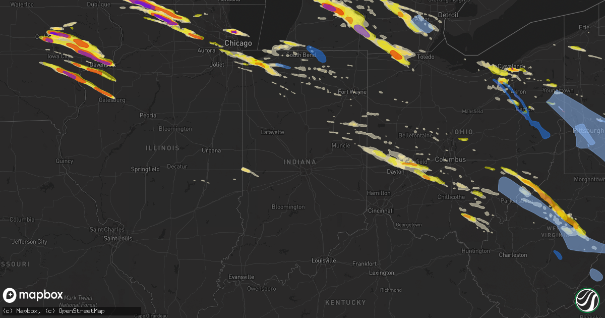
Hail Map in Indiana on April 7, 2020
Get this storm
April 7 map
$229
one time, instant access
Download today. No call, no setup
Keep the $229
Bought the map and want the full workflow? Apply the entire $229 to a subscription within 7 days. None of it is wasted.
Every map, not just this one
This buys you this map. Subscription and you get every map we run, in the markets you choose from a few cities to whole states to nationwide. Plus real-time alerts the moment a storm fires.
Contact data
Name, contact info, occupancy, even credit band for addresses in the footprint. You go from where it hit to who to call.
Become the source they trust
Unlimited branding weather history reports on demand. You already have the documented answer ready for the property owner, and you are the one who showed up with it.
Property data and RoofTrace estimates
Pull up any address you have got, its value and the exact code rules for that jurisdiction, straight from One Click Code. Then RoofTrace estimates the squares, pitch, and roof value, priced the way you price.
Storm reports in Indiana
Indiana
| Date | Description |
|---|---|
| 04/07/20205:45 AM CDT | At 1045 PM EDT, severe thunderstorms were located along a line extending from 6 miles northeast of Lagrange to Topeka, moving east at 45 mph. HAZARD...60 mph wind gusts and quarter size hail. SOURCE...Radar indicated. IMPACT...Hail damage to vehicles is expected. Expect wind damage to roofs, siding, and trees. Locations impacted include... Auburn, Kendallville, Angola, Lagrange, Waterloo, Hamilton, Rome City, Topeka, Wolcottville, Ashley, Hudson, Corunna, Flint, Fairfield Center, Lake Gauge, Brushy Prairie, Pleasant Lake, Hamilton Lake, Golden Lake and Big Long Lake.This includes the following highways... Interstate 69 in Indiana between mile markers 331 and 353. Interstate 80 in Indiana between mile markers 151 and 155. |
| 04/07/20205:41 AM CDT | At 1040 PM EDT/940 PM CDT/, a severe thunderstorm was located over Valparaiso, moving east at 45 mph. Nickel to quarter size hail has been reported in Valparaiso HAZARD...60 mph wind gusts and quarter size hail. SOURCE...Radar indicated. IMPACT...Hail damage to vehicles is expected. Expect wind damage to roofs, siding, and trees. Locations impacted include... Westville, Walkerton, Kingsford Heights, Wanatah, Hamlet, Koontz Lake, Oak Grove, Hanna, Kingsbury, Thomaston, Teegarden, Pinhook, South Center, Salem Heights, South Wanatah, Tracy, Tyner, Union Mills, Donaldson and Haskell. |
| 04/07/20205:08 AM CDT | At 1008 PM EDT, a severe thunderstorm was located near Edwardsburg, or near Granger, moving east at 30 mph. HAZARD...60 mph wind gusts and quarter size hail. SOURCE...Radar indicated. IMPACT...Hail damage to vehicles is expected. Expect wind damage to roofs, siding, and trees. Locations impacted include... Elkhart, Niles, Simonton Lake, Constantine, Bristol, Edwardsburg, Union, Mottville, Dailey, Barron Lake, Calvin Center, Adamsville, Juno Lake, Shavehead Lake and Eagle Lake.This includes Interstate 80 in Indiana between mile markers 89 and105. |
| 04/07/20204:36 AM CDT | At 935 PM EDT/835 PM CDT/, severe thunderstorms were located along a line extending from near Three Oaks to near Trail Creek, moving east at 35 mph. HAZARD...60 mph wind gusts and quarter size hail. SOURCE...Radar indicated. IMPACT...Hail damage to vehicles is expected. Expect wind damage to roofs, siding, and trees. Locations impacted include... South Bend, Michigan City, La Porte, Georgetown, Trail Creek, Granger, New Carlisle, Three Oaks, Roseland, Bertrand, Dayton, Galien, Indian Village, Byron, Hudson Lake, Waterford, Chain-o-lakes, Rolling Prarie, Crumstown and Hesston.This includes the following highways... Interstate 80 in Indiana between mile markers 45 and 79. Interstate 94 in Indiana between mile markers 34 and 41. |
| 04/07/20204:29 AM CDT | At 928 PM EDT, a severe thunderstorm was located near Bridgman, or 10 miles northwest of Buchanan, moving east at 30 mph. At 928 PM EDT...hail to the size of dimes was reported in Sawyer. HAZARD...Ping pong ball size hail and 60 mph wind gusts. SOURCE...Radar indicated. IMPACT...People and animals outdoors will be injured. Expect hail damage to roofs, siding, windows, and vehicles. Expect wind damage to roofs, siding, and trees. Locations impacted include... Niles, Buchanan, Bridgman, Shorewood-Tower Hill, Shorewood-Tower Hills-Harbert, Pokagon, Glendora, New Troy, Harbert, Dailey, Barron Lake, Sumnerville and Sawyer.This includes Interstate 94 in Michigan between mile markers 11 and16. |
| 04/07/20203:19 AM CDT | At 819 PM CDT, a severe thunderstorm was located over Hobart, moving east at 35 mph. HAZARD...Quarter size hail. SOURCE...Radar indicated. IMPACT...Damage to vehicles is expected. Locations impacted include... Gary, Portage, Merrillville, Valparaiso, Schererville, Hobart, Griffith, Chesterton, Lake Station, Porter, Burns Harbor, South Haven, Lincoln Hills, Wheeler, New Chicago and Kvpz.Including the following interstates... Indiana I-80 between mile markers 6 and 16. Indiana I-90 between mile markers 17 and 37. Indiana I-94 between mile markers 16 and 17. Indiana I-65 between mile markers 253 and 261.This includes...Indiana University Northwest, Valparaiso University, and Porter County Fairgrounds. |
| 04/06/20209:40 PM CDT | Two to three foot diameter tree down across road along with power lines down. Reported at 58152 county road 33... Middlebury... In. |
| 04/06/20209:35 PM CDT | Power lines down. Reported at 58670 county road 29 goshen... In. |
| 04/06/20209:35 PM CDT | Relayed via social media and time estimated by radar. |
| 04/06/20209:35 PM CDT | Public report sent via mping. |
| 04/06/20209:07 PM CDT | Time estimated via radar. |
| 04/06/20209:05 PM CDT | Time estimated via radar. |
| 04/06/20209:03 PM CDT | A local report indicates 1.00 inch wind near 1 NW PORTAGE |
| 04/06/20208:30 PM CDT | Time estimated via radar. |
All States Impacted by Hail Map on April 7, 2020
Cities Impacted by Hail Map on April 7, 2020
- New Kensington, PA
- Natrona Heights, PA
- Brackenridge, PA
- Tarentum, PA
- Bryant, IN
- Keystone, IN
- Geneva, IN
- Hartford City, IN
- Montpelier, IN
- Portland, IN
- Pennville, IN
- Galloway, OH
- Columbus, OH
- Pomeroy, OH
- Middleport, OH
- Marion, IA
- Berwick, PA
- South Solon, OH
- Bloomingburg, OH
- New Holland, OH
- Jeffersonville, OH
- Washington Court House, OH
- Kewanna, IN
- Springville, IA
- Alburnett, IA
- Jamestown, OH
- Cedarville, OH
- Taylor Ridge, IL
- Maple Heights, OH
- Independence, OH
- Bedford, OH
- Cleveland, OH
- Gratiot, WI
- South Whitley, IN
- Patriot, OH
- Gallipolis, OH
- Hope, MI
- Beaverton, MI
- Saegertown, PA
- Conneautville, PA
- Springboro, PA
- Venango, PA
- Joy, IL
- North English, IA
- Wapello, IA
- Letts, IA
- Alexis, IL
- Columbus Junction, IA
- North Henderson, IL
- Kalona, IA
- Riverside, IA
- Galesburg, IL
- Ainsworth, IA
- Muscatine, IA
- Seaton, IL
- New Boston, IL
- Parnell, IA
- Lone Tree, IA
- Wataga, IL
- Conesville, IA
- Aledo, IL
- Wellman, IA
- Clare, IL
- Monroe Center, IL
- Sycamore, IL
- Genoa, IL
- Kingston, IL
- Saint Charles, IL
- Hampshire, IL
- Esmond, IL
- Maple Park, IL
- Kirkland, IL
- Wauseon, OH
- Hopkins, MI
- Coldwater, MI
- Clayton, MI
- Union City, MI
- Martin, MI
- Litchfield, MI
- Marshall, MI
- Jasper, MI
- Hillsdale, MI
- Sand Creek, MI
- Galesburg, MI
- Augusta, MI
- Otsego, MI
- Delton, MI
- Ceresco, MI
- Richland, MI
- Delta, OH
- Homer, MI
- East Leroy, MI
- Jonesville, MI
- Morenci, MI
- Metamora, OH
- Pittsford, MI
- Kalamazoo, MI
- Plainwell, MI
- Osseo, MI
- Lyons, OH
- Fayette, OH
- Bellevue, MI
- Waldron, MI
- Allen, MI
- Hickory Corners, MI
- Burlington, MI
- Allegan, MI
- Battle Creek, MI
- Quincy, MI
- Hudson, MI
- Tekonsha, MI
- Climax, MI
- Arcadia, MI
- Bear Lake, MI
- Forestville, WI
- Algoma, WI
- Marlette, MI
- Brown City, MI
- Shickshinny, PA
- Orangeville, PA
- Clinton, OH
- Marshallville, OH
- Canal Fulton, OH
- Kennan, WI
- Hawkins, WI
- Catawba, WI
- Tony, WI
- Glen Flora, WI
- Ladysmith, WI
- Cedar Rapids, IA
- Colona, IL
- Donahue, IA
- Martelle, IA
- Stockton, IA
- Pleasant Valley, IA
- New Liberty, IA
- Norway, IA
- Anamosa, IA
- Fairfax, IA
- Walcott, IA
- Lowden, IA
- Moline, IL
- Hiawatha, IA
- Eldridge, IA
- Stanwood, IA
- Tipton, IA
- Hampton, IL
- Clarence, IA
- Olin, IA
- Bettendorf, IA
- Atkins, IA
- Wheatland, IA
- Solon, IA
- Silvis, IL
- Mechanicsville, IA
- Mount Vernon, IA
- Davenport, IA
- Calamus, IA
- Durant, IA
- Long Grove, IA
- Wilton, IA
- Lisbon, IA
- East Moline, IL
- Carbon Cliff, IL
- Dixon, IA
- Bennett, IA
- Ely, IA
- Browntown, WI
- Shullsburg, WI
- Orangeville, IL
- Juda, WI
- South Wayne, WI
- Davis, IL
- Monroe, WI
- Darlington, WI
- Rock City, IL
- Winslow, IL
- Dakota, IL
- Slinger, WI
- Grafton, WI
- Saukville, WI
- West Bend, WI
- Jackson, WI
- Hartford, WI
- Cedarburg, WI
- Durand, IL
- Winnebago, IL
- Bourbon, IN
- Alum Bridge, WV
- New Milton, WV
- Weston, WV
- Camden, WV
- Bay City, MI
- Saginaw, MI
- University Center, MI
- Essexville, MI
- Munger, MI
- Potterville, MI
- Grand Ledge, MI
- Rockford, IL
- Pecatonica, IL
- Milwaukee, WI
- Aurora, OH
- Mantua, OH
- McDonald, OH
- Mineral Ridge, OH
- Girard, OH
- Niles, OH
- Warren, OH
- Middleville, MI
- Caledonia, MI
- Star City, IN
- Winamac, IN
- Centerburg, OH
- Croton, OH
- Marietta, OH
- New Matamoras, OH
- Dexter City, OH
- Wingett Run, OH
- Whipple, OH
- Lower Salem, OH
- Macksburg, OH
- Mesick, MI
- Lake City, MI
- Buckley, MI
- Merritt, MI
- Manton, MI
- Kingsley, MI
- Humboldt, IL
- Hersey, MI
- Evart, MI
- Brodnax, VA
- Kenbridge, VA
- Rock Cave, WV
- New Boston, MI
- Belleville, MI
- Lakewood, NY
- Jamestown, NY
- Pinconning, MI
- Leroy, MI
- Cadillac, MI
- Rhodes, MI
- Harrison, MI
- Brethren, MI
- Onekama, MI
- Coleman, MI
- Clare, MI
- Marion, MI
- Midland, MI
- Gladwin, MI
- Linwood, MI
- Tustin, MI
- Wellston, MI
- Kaleva, MI
- Copemish, MI
- Boon, MI
- Auburn, MI
- Harrietta, MI
- Lake, MI
- McBain, MI
- Sanford, MI
- Chippewa Lake, MI
- Mecosta, MI
- Rodney, MI
- Valley City, OH
- Luxemburg, WI
- Casco, WI
- Sobieski, WI
- Pulaski, WI
- Little Suamico, WI
- Abrams, WI
- Brussels, WI
- Sturgeon Bay, WI
- Oconto, WI
- Krakow, WI
- Harrisville, WV
- Cairo, WV
- Milford, IN
- New Paris, IN
- Brunswick, OH
- Litchfield, OH
- Medina, OH
- North Royalton, OH
- Wadsworth, OH
- Spencer, OH
- Strongsville, OH
- Wellington, OH
- Columbia Station, OH
- Hinckley, OH
- Seville, OH
- McConnell, IL
- Winnetka, IL
- Glenview, IL
- Golf, IL
- Chicago, IL
- Wilmette, IL
- Morton Grove, IL
- Evanston, IL
- Skokie, IL
- Jackson, OH
- Thurman, OH
- Oak Hill, OH
- Vinton, OH
- Portage, IN
- Lake Station, IN
- Valparaiso, IN
- Hobart, IN
- Warsaw, VA
- Kilmarnock, VA
- White Stone, VA
- Weems, VA
- Machipongo, VA
- Cape Charles, VA
- Irvington, VA
- Farnham, VA
- Heathsville, VA
- Lancaster, VA
- Bruce, WI
- Exeland, WI
- Lake Odessa, MI
- Pandora, OH
- Bluffton, OH
- Cambridge Springs, PA
- Mcconnelsville, OH
- Blue Rock, OH
- Middlebourne, WV
- Friendly, WV
- Graysville, OH
- Lowell, OH
- Reno, OH
- Caldwell, OH
- Ellenboro, WV
- Cumberland, OH
- Saint Marys, WV
- Pennsboro, WV
- Chandlersville, OH
- Marysville, OH
- Ostrander, OH
- Coxs Mills, WV
- Beachwood, OH
- Shell Lake, WI
- Spooner, WI
- Blanchard, MI
- Shepherd, MI
- Mount Pleasant, MI
- Cherry Valley, IL
- Syracuse, IN
- Millersburg, IN
- Goshen, IN
- Menomonee Falls, WI
- Iowa City, IA
- Walker, WV
- Waverly, WV
- Olmsted Falls, OH
- North Olmsted, OH
- Elyria, OH
- Lorain, OH
- Avon, OH
- North Ridgeville, OH
- Sheffield Lake, OH
- Westlake, OH
- Circleville, OH
- Kingston, OH
- Laurelville, OH
- Croswell, MI
- Preston, MD
- Kenilworth, IL
- Niles, IL
- Des Plaines, IL
- Clifford, MI
- Imlay City, MI
- Fostoria, MI
- Attica, MI
- Mayville, MI
- North Branch, MI
- Nashville, MI
- Vermontville, MI
- Saint Louis, MI
- Merrill, MI
- Breckenridge, MI
- Freeland, MI
- Mchenry, IL
- Weidman, MI
- Berne, IN
- Calumet City, IL
- Plymouth, MI
- Mattawan, MI
- Ottawa Lake, MI
- Toledo, OH
- Erie, MI
- Lambertville, MI
- Temperance, MI
- Victoria, VA
- Lunenburg, VA
- Keysville, VA
- Wanatah, IN
- Hillsdale, IN
- Chillicothe, OH
- Wellston, OH
- Ray, OH
- Beaver, OH
- Emmett, MI
- Lowell, MI
- Alto, MI
- Farwell, MI
- Mecca, IN
- Rosedale, IN
- Montezuma, IN
- Clinton, IN
- Chrisman, IL
- Rockville, IN
- Dana, IN
- Port Washington, WI
- Rubicon, WI
- Robins, IA
- Grand Mound, IA
- Toddville, IA
- Palo, IA
- North Judson, IN
- San Pierre, IN
- Huntsville, OH
- Bellefontaine, OH
- Mount Zion, WV
- Arnoldsburg, WV
- Edmore, MI
- Morley, MI
- Howard City, MI
- Six Lakes, MI
- Newaygo, MI
- Lakeview, MI
- Charlotte, MI
- Dowling, MI
- Dorr, MI
- Shelbyville, MI
- Wayland, MI
- Monterey, IN
- Westville, IN
- Hammond, IN
- Hanna, IN
- Whiting, IN
- Gary, IN
- Dolton, IL
- Alsip, IL
- Union Mills, IN
- La Porte, IN
- La Crosse, IN
- Riverdale, IL
- Blue Island, IL
- East Chicago, IN
- Knox, IN
- Havertown, PA
- Haverford, PA
- Broomall, PA
- Ardmore, PA
- Wynnewood, PA
- Monroe, MI
- Maybee, MI
- Frewsburg, NY
- Russell, PA
- West Union, WV
- Cass, WV
- Arbovale, WV
- Durbin, WV
- Casstown, OH
- Troy, OH
- New Carlisle, OH
- Houghton Lake, MI
- Prudenville, MI
- Belmont, WI
- Pitsburg, OH
- Yellow Springs, OH
- Enon, OH
- West Milton, OH
- Medway, OH
- Tipp City, OH
- South Charleston, OH
- Vandalia, OH
- Greenville, OH
- London, OH
- Springfield, OH
- Laura, OH
- Englewood, OH
- Dayton, OH
- Fairborn, OH
- Ludlow Falls, OH
- Arcanum, OH
- Union City, IN
- Union City, OH
- Southgate, MI
- Allen Park, MI
- Lincoln Park, MI
- Taylor, MI
- Holland, MI
- Hamilton, MI
- Silverwood, MI
- Columbiaville, MI
- Allenton, MI
- Capac, MI
- Otter Lake, MI
- Lapeer, MI
- Melvin, MI
- Peck, MI
- Yale, MI
- Millington, MI
- Cambridge, IL
- Milan, IL
- Moscow, IA
- Reynolds, IL
- Orion, IL
- Sherrard, IL
- Lynn Center, IL
- Illinois City, IL
- West Liberty, IA
- Atalissa, IA
- Andalusia, IL
- Niles, MI
- Grand Rapids, MI
- Saint Marys, OH
- Whitehall, MI
- Sears, MI
- Barryton, MI
- Montague, MI
- Troy, WV
- Willow Springs, IL
- Bidwell, OH
- French Creek, WV
- Helvetia, WV
- Pickens, WV
- Tallmansville, WV
- Mill Creek, WV
- Nappanee, IN
- Walkersville, WV
- Saline, MI
- Hickory Hills, IL
- Palos Hills, IL
- Chicago Ridge, IL
- Bridgeview, IL
- Oak Lawn, IL
- Willowbrook, IL
- Freeport, MI
- Newton Falls, OH
- Leavittsburg, OH
- Massillon, OH
- Doylestown, OH
- North Lawrence, OH
- Buckhannon, WV
- Chelsea, MI
- Kingston, MI
- Vassar, MI
- Grand Rapids, OH
- Federalsburg, MD
- Bridgeville, DE
- Grass Lake, MI
- Munith, MI
- Ann Arbor, MI
- Stockbridge, MI
- Dexter, MI
- Manchester, MI
- Loves Park, IL
- Belvidere, IL
- Rockton, IL
- Machesney Park, IL
- Whitmore Lake, MI
- Mequon, WI
- Byron, IL
- Leaf River, IL
- Crivitz, WI
- Kawkawlin, MI
- Creston, OH
- Crooksville, OH
- Roseville, OH
- Berea, OH
- Brecksville, OH
- Macedonia, OH
- Hudson, OH
- Brookpark, OH
- Northfield, OH
- Chagrin Falls, OH
- Broadview Heights, OH
- Solon, OH
- Avon Lake, OH
- Celoron, NY
- Ashville, NY
- Bemus Point, NY
- Carsonville, MI
- Woodland, MI
- Birchwood, WI
- Buchanan, MI
- Sawyer, MI
- Three Oaks, MI
- New Troy, MI
- Galien, MI
- Nunica, MI
- Coopersville, MI
- Spring Lake, MI
- Mineral Point, WI
- Platteville, WI
- Deltaville, VA
- Callao, VA
- Ireland, WV
- Berkey, OH
- Byron Center, MI
- Blissfield, MI
- Athens, MI
- Adrian, MI
- Swanton, OH
- Dimondale, MI
- Mulliken, MI
- Lansing, MI
- Eaton Rapids, MI
- Mason, MI
- Pleasant Lake, MI
- Holt, MI
- Gregory, MI
- Britton, MI
- Pinckney, MI
- Clinton, MI
- Leslie, MI
- Dansville, MI
- Milan, MI
- Remus, MI
- Rockford, MI
- Belmont, MI
- South Rockwood, MI
- Flat Rock, MI
- Rockwood, MI
- Carleton, MI
- Romulus, MI
- Richwood, OH
- Michigan City, IN
- North Liberty, IA
- Parma, MI
- Albion, MI
- Olivet, MI
- Springport, MI
- Athens, OH
- Tobaccoville, NC
- Rural Hall, NC
- Ripley, NY
- Cuba City, WI
- Poplar Grove, IL
- Ridott, IL
- Warren, IL
- Stillman Valley, IL
- Argyle, WI
- Davis Junction, IL
- Lena, IL
- Freeport, IL
- Garden Prairie, IL
- Stockton, IL
- Nora, IL
- Ogema, WI
- Westboro, WI
- Rib Lake, WI
- Kelleys Island, OH
- Albion, IN
- Lakeview, OH
- Jane Lew, WV
- Hertel, WI
- Hudsonville, MI
- Jerome, MI
- Holland, OH
- Iron Ridge, WI
- Saugatuck, MI
- Douglas, MI
- North Adams, MI
- Zeeland, MI
- Fennville, MI
- Sylvania, OH
- Liberty Center, OH
- Hastings, MI
- Monticello, IA
- Langworthy, IA
- Elberon, VA
- Waverly, VA
- Spring Grove, VA
- Dendron, VA
- Selbyville, WV
- Crawford, WV
- Kanawha Head, WV
- Valley Head, WV
- Napier, WV
- Huttonsville, WV
- Hacker Valley, WV
- Kimmell, IN
- Granville, OH
- Newark, OH
- Hagerstown, MD
- Mechanicsburg, OH
- Urbana, OH
- Muskegon, MI
- Saint John, IN
- Crown Point, IN
- Frankenmuth, MI
- Bridgeport, MI
- Sunfield, MI
- Smithville, WV
- Auburn, WV
- Twin Lake, MI
- Caledonia, IL
- Westmont, IL
- Clarendon Hills, IL
- Downers Grove, IL
- Oak Brook, IL
- Albany, OH
- McArthur, OH
- Hamden, OH
- Wilkesville, OH
- Reese, MI
- Fairgrove, MI
- North Street, MI
- Jeddo, MI
- White Cloud, MI
- Smiths Creek, MI
- Port Huron, MI
- Fort Gratiot, MI
- Akron, MI
- Riverdale, MI
- Avoca, MI
- Memphis, MI
- Caro, MI
- Donnelsville, OH
- Palestine, OH
- Winchester, IN
- Bradford, OH
- New Castle, PA
- Orlando, WV
- Burnsville, WV
- Glenville, WV
- Linn, WV
- Sand Fork, WV
- Stanton, MI
- Delaware, OH
- Central City, IA
- Malvern, PA
- Newtown Square, PA
- West Chester, PA
- Rockbridge, OH
- Logan, OH
- Canton, MI
- Ypsilanti, MI
- Sigel, PA
- Forest Hill, MD
- Jarrettsville, MD
- Centerville, PA
- Guys Mills, PA
- Townville, PA
- Titusville, PA
- Chicago Heights, IL
- Crete, IL
- Steger, IL
- Raymond, OH
- Belle Center, OH
- Rushsylvania, OH
- Laotto, IN
- Avilla, IN
- Union Pier, MI
- New Buffalo, MI
- Novelty, OH
- Saint Helen, MI
- Woodstock, IL
- Newbury, OH
- Kendallville, IN
- Corunna, IN
- Ashley, IN
- Falmouth, MI
- Hillsdale, IL
- Stoutsville, OH
- Adelphi, OH
- Roanoke, IN
- Columbia City, IN
- Lakeside, MI
- Bridgman, MI
- Harbert, MI
- New Carlisle, IN
- Grovertown, IN
- Plymouth, IN
- Fort Wayne, IN
- Yoder, IN
- Slippery Rock, PA
- Coralville, IA
- Big Rapids, MI
- Paris, MI
- Webster, WI
- Siren, WI
- Sarona, WI
- West Chicago, IL
- Warrenville, IL
- Wheaton, IL
- Winfield, IL
- Vesuvius, VA
- Grandview, IA
- Marengo, IL
- Pleasantville, PA
- Butler, WI
- Rocky River, OH
- Columbus Grove, OH
- Menominee, MI
- South Lyon, MI
- Tecumseh, MI
- Dundee, MI
- Roscoe, IL
- Newport, OH
- Belmont, WV
- Cromwell, IN
- Ligonier, IN
- Dayton, PA
- Campbell, OH
- Struthers, OH
- Youngstown, OH
- Canfield, OH
- Lowellville, OH
- Slatyfork, WV
- Willshire, OH
- Decatur, IN
- Monroe, IN
- Rockford, OH
- Mendon, OH
- Argos, IN
- Marion, IN
- Dunkirk, IN
- Groveport, OH
- Lockbourne, OH
- Grove City, OH
- Orient, OH
- Ashville, OH
- Ashtabula, OH
- Goshen, VA
- Craigsville, VA
- Radisson, WI
- Winter, WI
- Merrill, WI
- Porterfield, WI
- Wallace, MI
- Paw Paw, MI
- Chesterton, IN
- Oberlin, OH
- Williamstown, WV
- Horner, WV
- Warsaw, IN
- Etna Green, IN
- Leesburg, IN
- Paris, IL
- New Plymouth, OH
- Creola, OH
- Vicksburg, MI
- Scotts, MI
- Fulton, MI
- Pleasant Hill, OH
- Brookville, OH
- Williamsport, OH
- Mount Sterling, OH
- North Hampton, OH
- Piqua, OH
- Clarksburg, OH
- Xenia, OH
- Covington, OH
- Seaford, DE
- Hometown, IL
- Merrillville, IN
- Griffith, IN
- Midlothian, IL
- Palos Heights, IL
- La Grange, IL
- South Holland, IL
- Palos Park, IL
- Evergreen Park, IL
- Posen, IL
- Crestwood, IL
- Worth, IL
- Darien, IL
- Robbins, IL
- Pierceton, IN
- Claypool, IN
- Erie, PA
- Freeport, PA
- Vandergrift, PA
- Bentley, MI
- Bryn Mawr, PA
- Stone Lake, WI
- Tomahawk, WI
- Alberta, VA
- Hiram, OH
- Gibsonia, PA
- Pewaukee, WI
- Sussex, WI
- Windham, OH
- Du Bois, PA
- Charleston, IL
- Jonesboro, IN
- Upland, IN
- Fowlerton, IN
- Fairmount, IN
- Elwell, MI
- Clarksville, MI
- Ada, MI
- South Bend, IN
- Walkerton, IN
- Bremen, IN
- Lakeville, IN
- Dryden, MI
- Metamora, MI
- Mill Creek, IN
- Rolling Prairie, IN
- Streetsboro, OH
- Lewisville, OH
- Summerfield, OH
- Rutland, OH
- Langsville, OH
- Lawrenceville, VA
- New Haven, IN
- New Marshfield, OH
- South Bloomingville, OH
- Baileys Harbor, WI
- Fish Creek, WI
- Dublin, OH
- Nelsonville, OH
- Amesville, OH
- Millfield, OH
- The Plains, OH
- Chauncey, OH
- Munster, IN
- Dyer, IN
- Lansing, IL
- Hazel Crest, IL
- Homewood, IL
- Highland, IN
- Country Club Hills, IL
- Schererville, IN
- Glenwood, IL
- Ridgeville, IN
- Redkey, IN
- Muncie, IN
- Eaton, IN
- Albany, IN
- Houston, OH
- Enfield, NC
- Ashley, OH
- Grantsburg, WI
- Wyoming, MI
- Edwardsburg, MI
- Berea, WV
- Pullman, WV
- Ossian, IN
- Vermilion, OH
- German Valley, IL
- Petroleum, WV
- Parkersburg, WV
- Elburn, IL
- West Branch, IA
- Rockton, PA
- Carrollton, MI
- Gallipolis Ferry, WV
- Rio Grande, OH
- Haviland, OH
- Paulding, OH
- Marne, MI
- Barronett, WI
- Woodsfield, OH
- Middlebrook, VA
- Raphine, VA
- Ojibwa, WI
- Apple River, IL
- Scales Mound, IL
- Garrettsville, OH
- Limaville, OH
- Atwater, OH
- Alliance, OH
- Inkster, MI
- Westland, MI
- Wayne, MI
- Dearborn Heights, MI
- Mentone, IN
- Warren, PA
- Concord, MI
- Hanover, MI
- Smithfield, VA
- Suffolk, VA
- Arlington Heights, IL
- Northbrook, IL
- Mount Prospect, IL
- Prospect Heights, IL
- Glen Ellyn, IL
- Russia, OH
- Versailles, OH
- Paris, OH
- Louisville, OH
- East Canton, OH
- Sullivan, IL
- Ridgeway, OH
- West Mansfield, OH
- Fort Jennings, OH
- Oxford, IA
- Amanda, OH
- Granger, IN
- Elkhart, IN
- Burbank, OH
- West Salem, OH
- Grandville, MI
- Columbiana, OH
- Leetonia, OH
- Salem, OH
- Henderson, WV
- Apple Grove, WV
- Fletcher, OH
- Willis, MI
- Mishawaka, IN
- Richfield, OH
- Warren, IN
- Van Buren, IN
- Vestaburg, MI
- Portland, MI
- Rittman, OH
- Elgin, IL
- Dekalb, IL
- Cedarville, IL
- Fort Loramie, OH
- Burkettsville, OH
- New Weston, OH
- Saint Henry, OH
- Salamonia, IN
- Rossburg, OH
- Fort Recovery, OH
- Tippecanoe, IN
- Lairdsville, PA
- Hughesville, PA
- Stillwater, PA
- Unityville, PA
- Muncy, PA
- Millville, PA
- Nescopeck, PA
- Benton, PA
- Le Claire, IA
- Port Byron, IL
- Newhall, IA
- Rock Island, IL
- Montpelier, IA
- Blue Grass, IA
- Coal Valley, IL
- Nichols, IA
- Fruitland, IA
- Manistee, MI
- Thompsonville, MI
- Fife Lake, MI
- Houghton Lake Heights, MI
- Ellicott City, MD
- Marriottsville, MD
- Woodstock, MD
- West Friendship, MD
- Sykesville, MD
- Somerset, OH
- New Lexington, OH
- Mount Perry, OH
- Philo, OH
- Washingtonville, OH
- East Sparta, OH
- Canton, OH
- Sunbury, OH
- Oconto Falls, WI
- Dickeyville, WI
- Potosi, WI
- Justice, IL
- Wasco, IL
- Lombard, IL
- Bristol, IN
- Middlebury, IN
- Union, MI
- Kingsford Heights, IN
- Hamlet, IN
- Parkton, MD
- White Hall, MD
- Street, MD
- Aberdeen, MD
- Monkton, MD
- Fallston, MD
- Churchville, MD
- Bel Air, MD
- Brentwood, MD
- Cabin John, MD
- Riverdale, MD
- Potomac, MD
- Capitol Heights, MD
- Chevy Chase, MD
- Hyattsville, MD
- Washington, DC
- Bladensburg, MD
- Takoma Park, MD
- Mount Rainier, MD
- Bethesda, MD
- Glen Echo, MD
- Edinboro, PA
- Mount Solon, VA
- Beverly, OH
- Stewart, OH
- Blue Grass, VA
- Doe Hill, VA
- Webster Springs, WV
- Head Waters, VA
- Cleveland, WV
- Dunmore, WV
- Copen, WV
- Little Hocking, OH
- McDowell, VA
- Mineral Wells, WV
- Brohard, WV
- Cowen, WV
- Heaters, WV
- Belpre, OH
- Diana, WV
- Davisville, WV
- Flatwoods, WV
- Malta, OH
- Churchville, VA
- Big Springs, WV
- Bartow, WV
- Vienna, WV
- Vincent, OH
- West Augusta, VA
- Coal Run, OH
- Fishersville, VA
- Lyndhurst, VA
- Waynesboro, VA
- Swoope, VA
- Stockport, OH
- Williamsville, VA
- Washington, WV
- Elizabeth, WV
- Bergoo, WV
- Sutton, WV
- Monterville, WV
- Cutler, OH
- Stuarts Draft, VA
- Monterey, VA
- Macfarlan, WV
- Chesterhill, OH
- Staunton, VA
- Fleming, OH
- Waterford, OH
- Green Bank, WV
- Craigsville, WV
- Fenwick, WV
- Camden On Gauley, WV
- Tioga, WV
- Summersville, WV
- Calvin, WV
- Slickville, PA
- Bethel Park, PA
- Glassport, PA
- North Lima, OH
- Bolivar, PA
- Bradfordwoods, PA
- New Waterford, OH
- Champion, PA
- Blairsville, PA
- Mount Braddock, PA
- Wickhaven, PA
- Indianola, PA
- Homestead, PA
- New Springfield, OH
- Stoystown, PA
- Clinton, PA
- Turtle Creek, PA
- Midland, PA
- Webster, PA
- Mars, PA
- Perryopolis, PA
- Valencia, PA
- Eighty Four, PA
- Irwin, PA
- Pitcairn, PA
- Donegal, PA
- Waltersburg, PA
- Elizabeth, PA
- Roscoe, PA
- Lawrence, PA
- Jerome, PA
- Warrendale, PA
- Greenock, PA
- Saxonburg, PA
- Boswell, PA
- New Alexandria, PA
- Luxor, PA
- Jeannette, PA
- Crabtree, PA
- Hollsopple, PA
- Youngstown, PA
- Bessemer, PA
- Smithton, PA
- Coraopolis, PA
- Edinburg, PA
- Lowber, PA
- Jones Mills, PA
- East Palestine, OH
- Bakerstown, PA
- Somerset, PA
- Butler, PA
- Tarrs, PA
- Yukon, PA
- Shippingport, PA
- East Liverpool, OH
- Cranberry Township, PA
- Dickerson Run, PA
- Ardara, PA
- Rector, PA
- Harrison City, PA
- Sutersville, PA
- Monessen, PA
- Grindstone, PA
- Bovard, PA
- Windber, PA
- Georgetown, PA
- Indian Head, PA
- Bradenville, PA
- Mill Run, PA
- Derry, PA
- Rochester, PA
- Gray, PA
- Allenport, PA
- Morgan, PA
- Bunola, PA
- Markleton, PA
- Delmont, PA
- Carnegie, PA
- Cuddy, PA
- Elco, PA
- Wyano, PA
- Ruffs Dale, PA
- Mckeesport, PA
- Rogers, OH
- Petersburg, OH
- Koppel, PA
- Josephine, PA
- Negley, OH
- New Florence, PA
- Conway, PA
- Trafford, PA
- Fombell, PA
- Export, PA
- Manor, PA
- Adamsburg, PA
- Duquesne, PA
- North Versailles, PA
- Clarksburg, PA
- Wexford, PA
- Seward, PA
- Hillsville, PA
- Ellwood City, PA
- Apollo, PA
- Finleyville, PA
- Callery, PA
- Vanderbilt, PA
- West Elizabeth, PA
- Evans City, PA
- Hooversville, PA
- Portersville, PA
- Allison Park, PA
- Connellsville, PA
- Seanor, PA
- Black Lick, PA
- Bulger, PA
- Greensburg, PA
- Charleroi, PA
- Meadow Lands, PA
- Penn, PA
- Wampum, PA
- Ohiopyle, PA
- Darragh, PA
- New Brighton, PA
- Dunbar, PA
- Loyalhanna, PA
- Oakmont, PA
- Muse, PA
- Clairton, PA
- Freedom, PA
- West Newton, PA
- Sewickley, PA
- New Stanton, PA
- New Galilee, PA
- Rillton, PA
- Westmoreland City, PA
- Davidsville, PA
- Sturgeon, PA
- Fayette City, PA
- East McKeesport, PA
- Washington, PA
- Cheswick, PA
- Canonsburg, PA
- Normalville, PA
- Beaver Falls, PA
- Everson, PA
- Jennerstown, PA
- Jenners, PA
- Ligonier, PA
- Confluence, PA
- Acme, PA
- Rockwood, PA
- Harwick, PA
- White, PA
- Scottdale, PA
- Aliquippa, PA
- Lemont Furnace, PA
- Grapeville, PA
- Friedens, PA
- Murrysville, PA
- McDonald, PA
- Presto, PA
- Verona, PA
- Coal Center, PA
- Sarver, PA
- West Pittsburg, PA
- Russellton, PA
- Industry, PA
- Saltsburg, PA
- Ambridge, PA
- West Mifflin, PA
- Elton, PA
- New Eagle, PA
- Uniontown, PA
- Crescent, PA
- Avonmore, PA
- Alverton, PA
- Larimer, PA
- Johnstown, PA
- Arona, PA
- Forbes Road, PA
- Beaver, PA
- Pleasant Unity, PA
- Hidden Valley, PA
- Houston, PA
- Wilmerding, PA
- Leechburg, PA
- Hostetter, PA
- Youngwood, PA
- Mount Pleasant, PA
- Acosta, PA
- Robinson, PA
- Braddock, PA
- Dunlevy, PA
- Stahlstown, PA
- Elrama, PA
- New Middletown, OH
- Leetsdale, PA
- East Pittsburgh, PA
- Cecil, PA
- McKees Rocks, PA
- Dawson, PA
- Salix, PA
- Buena Vista, PA
- Venetia, PA
- Bentleyville, PA
- Oakdale, PA
- Monongahela, PA
- Baden, PA
- Smock, PA
- Zelienople, PA
- South Park, PA
- Monroeville, PA
- New Derry, PA
- Donora, PA
- Darlington, PA
- Dravosburg, PA
- Hookstown, PA
- Hannastown, PA
- Hunker, PA
- Monaca, PA
- Lisbon, OH
- Melcroft, PA
- Springdale, PA
- Enon Valley, PA
- Stockdale, PA
- Bairdford, PA
- Strabane, PA
- Claridge, PA
- Bridgeville, PA
- South Heights, PA
- North Apollo, PA
- Pittsburgh, PA
- Van Voorhis, PA
- Star Junction, PA
- Latrobe, PA
- Renfrew, PA
- Creighton, PA
- Harmony, PA
- Herminie, PA
- Belle Vernon, PA
- Quecreek, PA
- Glenshaw, PA
- Southview, PA
- East Vandergrift, PA
- Imperial, PA
- Madison, PA
- Laughlintown, PA
- Frostburg, MD
- Grantsville, MD
- Lonaconing, MD
- Oldtown, MD
- Green Spring, WV
- Glengary, WV
- Berkeley Springs, WV
- Paw Paw, WV
- Great Cacapon, WV
- Cross Junction, VA
- Hedgesville, WV
- Winchester, VA
- Cumberland, MD
- Ridgeley, WV
- Bunker Hill, WV
- Slanesville, WV
- Gerrardstown, WV
- Levels, WV
- Wiley Ford, WV
- Springfield, WV
- Bloomery, WV
- Buckeystown, MD
- Shenandoah Junction, WV
- Shepherdstown, WV
- Washington Grove, MD
- Jefferson, MD
- Kearneysville, WV
- Rockville, MD
- New Market, MD
- Keedysville, MD
- Monrovia, MD
- Barnesville, MD
- Gaithersburg, MD
- Sharpsburg, MD
- Inwood, WV
- Germantown, MD
- Derwood, MD
- Boonsboro, MD
- Boyds, MD
- Clarksburg, MD
- Damascus, MD
- Mount Airy, MD
- Olney, MD
- Braddock Heights, MD
- Martinsburg, WV
- Adamstown, MD
- Dickerson, MD
- Montgomery Village, MD
- Middletown, MD
- Rohrersville, MD
- Brownsville, MD
- Harpers Ferry, WV
- Frederick, MD
- Knoxville, MD
- Ijamsville, MD
- Burkittsville, MD
- Brookeville, MD
- Adrian, WV
- Mabie, WV
- Hot Springs, VA
- Millboro, VA
- Warm Springs, VA
- Bacova, VA
- Monroe, VA
- Madison Heights, VA
- Lynchburg, VA
- Amherst, VA
- Rockbridge Baths, VA
- Lexington, VA
- Buena Vista, VA
- Meherrin, VA
- Roseland, VA
- Tyro, VA
- Greenville, VA
- Montebello, VA
- Steeles Tavern, VA
- Deerfield, VA
- Carrollton, OH
- Navarre, OH
- Cadiz, OH
- Hopedale, OH
- Bowerston, OH
- Sandyville, OH
- Dellroy, OH
- Scio, OH
- Waynesburg, OH
- Sherrodsville, OH
- Amsterdam, OH
- Jewett, OH
- Magnolia, OH
- Mineral City, OH
- Grafton, OH
- Bloomingdale, OH
- Barberton, OH
- Uniontown, OH
- North Canton, OH
- Akron, OH


