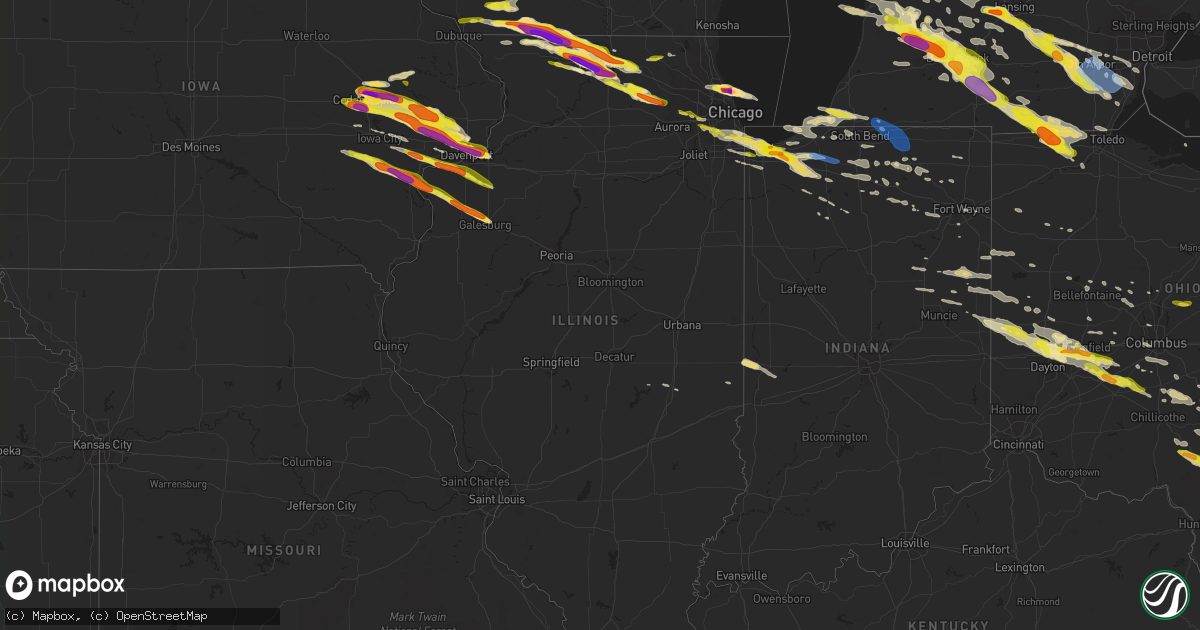
Hail Map in Illinois on April 7, 2020
Get this storm
April 7 map
$229
one time, instant access
Download today. No call, no setup
Keep the $229
Bought the map and want the full workflow? Apply the entire $229 to a subscription within 7 days. None of it is wasted.
Every map, not just this one
This buys you this map. Subscription and you get every map we run, in the markets you choose from a few cities to whole states to nationwide. Plus real-time alerts the moment a storm fires.
Contact data
Name, contact info, occupancy, even credit band for addresses in the footprint. You go from where it hit to who to call.
Become the source they trust
Unlimited branding weather history reports on demand. You already have the documented answer ready for the property owner, and you are the one who showed up with it.
Property data and RoofTrace estimates
Pull up any address you have got, its value and the exact code rules for that jurisdiction, straight from One Click Code. Then RoofTrace estimates the squares, pitch, and roof value, priced the way you price.
Storm reports in Illinois
Illinois
| Date | Description |
|---|---|
| 04/07/20206:59 PM CDT | Public report via mping. |
| 04/07/20206:40 PM CDT | Multiple pictures shared via social media of hail up to golf ball size near lake summerset and durand. Time estimated by radar. |
| 04/07/20206:28 PM CDT | Emergency management forwarded several photos of 1 to 3 inch hail in this area. Time of the event was estimated using radar. |
| 04/07/20206:20 PM CDT | Relayed from broadcast media. |
| 04/07/20206:15 PM CDT | Delayed report: nws employee observed 1.5 to 1.75 inch hail around the intersection of hgwy-69 and hgwy-26 along the wi/il state line. Hail was accumulating along the r |
| 04/07/20205:48 AM CDT | At 1048 PM CDT, a severe thunderstorm was located near North Henderson, or 7 miles northwest of Galesburg, moving southeast at 40 mph. HAZARD...Half dollar size hail. SOURCE...Radar indicated. IMPACT...Damage to vehicles is expected. Locations impacted include... Galesburg, Knoxville, Wataga, Yates City, Williamsfield, Gilson, East Galesburg, Henderson, Dahinda and Galesburg Airport.This includes Interstate 74 between mile markers 41 and 68. |
| 04/07/20205:43 AM CDT | At 1043 PM CDT, a severe thunderstorm was located over North Henderson, or 10 miles northwest of Galesburg, moving east at 45 mph. HAZARD...Half dollar size hail. SOURCE...Radar indicated. IMPACT...Damage to vehicles is expected. Locations impacted include... North Henderson and Alexis. |
| 04/07/20205:09 AM CDT | At 1008 PM CDT, a severe thunderstorm was located over Joy, or 7 miles west of Aledo, moving east at 50 mph. HAZARD...Golf ball size hail. SOURCE...Law enforcement. This storm has a history of producing up to 2 inch diameter hail. IMPACT...People and animals outdoors will be injured. Expect damage to roofs, siding, windows, and vehicles. Locations impacted include... Aledo, Burgess, Viola, Millersburg, Joy, Seaton, North Henderson, Shale City, New Windsor, Mannon, Alexis, Aledo Mercer County Airport, Wanlock, Gilchrist, Sunbeam, Old Gilchrist and Mercer County Fairgrounds. |
| 04/07/20204:57 AM CDT | At 957 PM CDT, a severe thunderstorm was located over Sherrard, or 10 miles south of Moline, moving east at 50 mph. HAZARD...60 mph wind gusts and quarter size hail. SOURCE...Radar indicated. IMPACT...Hail damage to vehicles is expected. Expect wind damage to roofs, siding, and trees. Locations impacted include... Kewanee, Cambridge, Milan, Coal Valley, Galva, Orion, Woodhull, Sherrard, Andover, Cable, Warner, Lynn Center, Preemption, Osco, Bishop Hill, Henry County Fairgrounds, Ophiem, German Corner, Coyne Center and Sunny Hill.This includes Interstate 74 in Illinois between mile markers 17 and31. |
| 04/07/20204:40 AM CDT | At 940 PM CDT, a severe thunderstorm was located over Letts, or 7 miles northeast of Columbus Junction, moving east at 45 mph. HAZARD...Two inch hail. SOURCE...Radar indicated. IMPACT...People and animals outdoors will be injured. Expect damage to roofs, siding, windows, and vehicles. Locations impacted include... Muscatine, Fruitland, Grandview, Eliza, Joy, Letts, Mannon, Cranston, Petersville, Ardon, Muscatine Municipal Airport and Flaming Prairie Park. |
| 04/07/20204:30 AM CDT | Dime to quarter sized hail. |
| 04/07/20204:07 AM CDT | At 907 PM CDT, a severe thunderstorm was located near Atalissa, or 7 miles north of Muscatine, moving east at 50 mph. HAZARD...Half dollar size hail. SOURCE...Radar indicated. IMPACT...Damage to vehicles is expected. Locations impacted include... Davenport, Muscatine, Wilton, Blue Grass, Buffalo, Andalusia, Atalissa, Montpelier, Illinois City, Fairport, Edgington, Clark's Ferry Recreation Area, West Lake Park, New Era, Pleasant Prairie, Moscow, Saulsbury Bridge Campground, Buffalo Shores, Loud Thunder Scout Camp and Midway Beach.This includes Interstate 280 between mile markers 5 and 8. |
| 04/07/20203:55 AM CDT | At 854 PM CDT, severe thunderstorms were located along a line extending from Alsip to Hobart to near Valparaiso, moving east at 30 mph. HAZARD...60 mph wind gusts and quarter size hail. SOURCE...Radar indicated. IMPACT...Hail damage to vehicles is expected. Expect wind damage to roofs, siding, and trees. Locations impacted include... Hammond, Gary, Calumet City, Portage, Merrillville, Valparaiso, East Chicago, Schererville, Hobart, Lansing, Highland, Munster, Griffith, Chesterton, Lake Station, Lynwood, Whiting, Porter, Burns Harbor and Wheeler.Including the following interstates... Indiana I-80 between mile markers 1 and 16. Indiana I-90 between mile markers 3 and 37. Indiana I-94 between mile markers 16 and 27. Indiana I-65 between mile markers 253 and 261.This includes...Indiana University Northwest, Purdue University Northwest Hammond, Valparaiso University, and Porter County Fairgrounds. |
| 04/07/20203:40 AM CDT | At 839 PM CDT, severe thunderstorms were located along a line extending from Englewood to near Homer Glen, moving southeast at 30 mph. HAZARD...60 mph wind gusts and quarter size hail. SOURCE...Radar indicated. IMPACT...Hail damage to vehicles is expected. Expect wind damage to roofs, siding, and trees. Locations impacted include... Chicago, Orland Park, Tinley Park, Oak Lawn, Calumet City, Chicago Heights, Lansing, Blue Island, Dolton, Park Forest, Alsip, Matteson, Frankfort, Lemont, Midlothian, Justice, Chatham, Worth, Steger and Flossmoor.Including the following interstates... I-57 between mile markers 339 and 358. I-80 between mile markers 150 and 155. I-90 between mile markers 104 and 107. I-94 between mile markers 61 and 74. I-294 between mile markers 61 and 74.This includes...Hollywood Casino Amphitheatre, Moraine Valley Community College, Prairie State College, and South Suburban College. |
| 04/07/20203:38 AM CDT | At 837 PM CDT, a severe thunderstorm was located over Sycamore, moving east at 40 mph. HAZARD...Half dollar size hail. SOURCE...Radar indicated. IMPACT...Damage to vehicles is expected. This severe thunderstorm will be near, Maple Park and Virgil around 850 PM CDT. Elburn and Lily Lake around 855 PM CDT. St. Charles around 905 PM CDT. Geneva, North Aurora and Wayne around 910 PM CDT. Batavia around 915 PM CDT. West Chicago around 920 PM CDT.Other locations impacted by this severe thunderstorm include SouthElgin and Burlington.This includes...Fermilab. |
| 04/07/20203:17 AM CDT | At 817 PM CDT, a severe thunderstorm was located over Wheaton, moving southeast at 15 mph. HAZARD...Quarter size hail. SOURCE...Radar indicated. IMPACT...Damage to vehicles is expected. Locations impacted include... Chicago, Cicero, Oak Lawn, Berwyn, Downers Grove, Lombard, Westmont, Brookfield, Hinsdale, Westchester, Lemont, La Grange, Justice, Summit, Worth, Lyons, Burr Ridge, Riverside, Oak Brook and Stickney.Including the following interstates... I-55 between mile markers 271 and 289. I-88 between mile markers 134 and 135. I-355 between mile markers 15 and 17.This includes...Argonne National Laboratory, Brookfield Zoo, SeatGeek Stadium, and Moraine Valley Community College. |
| 04/07/20202:27 AM CDT | At 726 PM CDT, two severe thunderstorms were located near Belvidere and over the Rockford Airport, moving east-southeast at 40 mph. HAZARD...Golf ball size hail and 60 mph wind gusts. SOURCE...Radar indicated. IMPACT...People and animals outdoors will be injured. Expect hail damage to roofs, siding, windows, and vehicles. Expect wind damage to roofs, siding, and trees. Locations impacted include... Sycamore, Marengo, Genoa, DeKalb, Lake In The Hills, Huntley, Hampshire, Cortland, Kirkland, Maple Park, Kingston, Lily Lake, Virgil, Pingree Grove, Davis Junction, Burlington and Union.Including the following interstates... I-39 between mile markers 110 and 114. I-90 between mile markers 32 and 48. |
| 04/07/20202:18 AM CDT | At 718 PM CDT, a severe thunderstorm was located over Freeport, moving east at 65 mph. HAZARD...Quarter size hail. SOURCE...Radar indicated. IMPACT...Damage to vehicles is expected. Locations impacted include... Freeport, German Valley, Ridott, Scioto Mills, Winneshiek, Albertus Airport and Stephenson County Fairgrounds. |
| 04/07/20202:01 AM CDT | At 700 PM CDT, two severe thunderstorms were located near Pecatonica and near Machesney Park, moving east-southeast at 35 mph. HAZARD...60 mph wind gusts and half dollar size hail. SOURCE...Radar indicated. IMPACT...Hail damage to vehicles is expected. Expect wind damage to roofs, siding, and trees. Locations impacted include... Rockford, Belvidere, Loves Park, Machesney Park, Rockford Airport, Roscoe, Poplar Grove, Cherry Valley, Winnebago, Pecatonica, Capron, Timberlane, Caledonia, Davis Junction and New Millford.Including the following interstates... I-39 between mile markers 115 and 123. I-90 between mile markers 6 and 31.This includes...Boone County Fairgrounds, Rock Cut State Park, Rock Valley College, Rockford Rivets Baseball, Rockford Speedway, and Winnebago County Fairgrounds. |
| 04/07/20201:51 AM CDT | At 651 PM CDT, severe thunderstorms were located along a line extending from near Wonder Lake to near Marengo, moving east at 40 mph. HAZARD...60 mph wind gusts and quarter size hail. SOURCE...Radar indicated. IMPACT...Hail damage to vehicles is expected. Expect wind damage to roofs, siding, and trees. Locations impacted include... Waukegan, Buffalo Grove, North Chicago, Gurnee, Mundelein, Highland Park, McHenry, Vernon Hills, Woodstock, Zion, Grayslake, Libertyville, Lake Zurich, Lake Forest, Round Lake, Deerfield, Beach Park, Wauconda, Fox Lake and Lake Villa.Including the following interstates... I-94 between mile markers 2 and 24. I-294 between mile markers 2 and 24.This includes...Chain O Lakes State Park, College of Lake County, Great Lakes Naval Training Center, IL Beach State Park, Lake County IL Fairgrounds, Lake Forest College, Mchenry County College, Mchenry County Fairgrounds, Moraine Hills State Park, Ravinia Music Festival, and Six Flags Great America. |
| 04/07/20201:14 AM CDT | At 614 PM CDT, a severe thunderstorm was located near Rock City, or 9 miles southeast of Monroe, moving east at 40 mph. HAZARD...Golf ball size hail and 60 mph wind gusts. SOURCE...Radar indicated. IMPACT...People and animals outdoors will be injured. Expect hail damage to roofs, siding, windows, and vehicles. Expect wind damage to roofs, siding, and trees. Locations impacted include... Rockford, Loves Park, Machesney Park, South Beloit, Rockton, Roscoe, Cherry Valley, Winnebago, Pecatonica, Durand and Lake Summerset.Including the following interstates... I-39 between mile markers 119 and 123. I-90 between mile markers 1 and 18.This includes...Rock Cut State Park, Rock Valley College, Rockford Rivets Baseball, Rockford Speedway, and Winnebago County Fairgrounds. |
| 04/06/202011:01 PM CDT | Several reports on social media of 1 to 1.5 inch diameter hail between galesburg and henderson. |
| 04/06/202010:45 PM CDT | Hail was 3/4 to 1.5 inches with most stones at quarter sized. |
| 04/06/20209:44 PM CDT | Via social media. Manly nickel size but some quarter size hail. |
| 04/06/20209:15 PM CDT | Public report via mping. |
| 04/06/20209:00 PM CDT | A local report indicates 1.50 inch wind near 1 N CARBON CLIFF |
| 04/06/20208:47 PM CDT | Time estimated via radar. |
| 04/06/20208:43 PM CDT | Near peace road and il-23. |
| 04/06/20208:32 PM CDT | Multiple photos shared via social media of hail up to baseball size in evanston. Delayed report... Time estimated via radar. |
| 04/06/20208:32 PM CDT | Numerous additional public reports of hail larger than quarter size in vicinity. Time estimated via radar. |
| 04/06/20208:28 PM CDT | Public report via mping. |
| 04/06/20208:27 PM CDT | Time estimated by radar. |
| 04/06/20208:25 PM CDT | A local report indicates 1.00 inch wind near 1 ESE GLENVIEW |
| 04/06/20208:22 PM CDT | Gusts up to 40 mph. |
| 04/06/20208:20 PM CDT | Time estimated via radar. |
| 04/06/20208:02 PM CDT | A local report indicates 1.00 inch wind near 2 SSE GENOA |
| 04/06/20208:00 PM CDT | Multiple public reports of 1 in diameter hail just south of genoa. |
| 04/06/20207:37 PM CDT | A local report indicates 1.00 inch wind near BELVIDERE |
| 04/06/20207:28 PM CDT | Public report of 2 in hail along i-39 near new milford. |
| 04/06/20207:28 PM CDT | Picture shared via social media of hail larger than quarter size near linden rd and 35th street. Time estimated via radar. |
| 04/06/20207:26 PM CDT | A local report indicates 1.25 inch wind near ROCKFORD AIRPORT |
| 04/06/20207:25 PM CDT | A local report indicates 1.25 inch wind near TIMBERLANE |
| 04/06/20207:24 PM CDT | A local report indicates 1.00 inch wind near 2 N ROCKFORD AIRPORT |
| 04/06/20207:21 PM CDT | A local report indicates 1.75 inch wind near 2 NNE NEW MILFORD |
| 04/06/20207:19 PM CDT | A local report indicates 1.00 inch wind near FREEPORT |
| 04/06/20207:19 PM CDT | A local report indicates 1.00 inch wind near 3 NNW CHERRY VALLEY |
| 04/06/20207:17 PM CDT | Picture shared on social media of 2 in hail southeast of winnebago. |
| 04/06/20207:15 PM CDT | Damage to siding and cars from hail. Largest were approximately 3 inches in diameter. |
| 04/06/20207:15 PM CDT | A local report indicates 1.00 inch wind near 2 NNW ROCKFORD |
| 04/06/20207:12 PM CDT | A local report indicates 1.00 inch wind near WOODSTOCK |
| 04/06/20207:12 PM CDT | A local report indicates 1.00 inch wind near MACHESNEY PARK |
| 04/06/20207:10 PM CDT | Public report via mping. |
| 04/06/20207:10 PM CDT | A local report indicates 2.00 inch wind near WINNEBAGO |
| 04/06/20207:09 PM CDT | A local report indicates 1.00 inch wind near PECATONICA |
| 04/06/20207:07 PM CDT | Public report via mping. |
All States Impacted by Hail Map on April 7, 2020
Cities Impacted by Hail Map on April 7, 2020
- New Kensington, PA
- Natrona Heights, PA
- Brackenridge, PA
- Tarentum, PA
- Bryant, IN
- Keystone, IN
- Geneva, IN
- Hartford City, IN
- Montpelier, IN
- Portland, IN
- Pennville, IN
- Galloway, OH
- Columbus, OH
- Pomeroy, OH
- Middleport, OH
- Marion, IA
- Berwick, PA
- South Solon, OH
- Bloomingburg, OH
- New Holland, OH
- Jeffersonville, OH
- Washington Court House, OH
- Kewanna, IN
- Springville, IA
- Alburnett, IA
- Jamestown, OH
- Cedarville, OH
- Taylor Ridge, IL
- Maple Heights, OH
- Independence, OH
- Bedford, OH
- Cleveland, OH
- Gratiot, WI
- South Whitley, IN
- Patriot, OH
- Gallipolis, OH
- Hope, MI
- Beaverton, MI
- Saegertown, PA
- Conneautville, PA
- Springboro, PA
- Venango, PA
- Joy, IL
- North English, IA
- Wapello, IA
- Letts, IA
- Alexis, IL
- Columbus Junction, IA
- North Henderson, IL
- Kalona, IA
- Riverside, IA
- Galesburg, IL
- Ainsworth, IA
- Muscatine, IA
- Seaton, IL
- New Boston, IL
- Parnell, IA
- Lone Tree, IA
- Wataga, IL
- Conesville, IA
- Aledo, IL
- Wellman, IA
- Clare, IL
- Monroe Center, IL
- Sycamore, IL
- Genoa, IL
- Kingston, IL
- Saint Charles, IL
- Hampshire, IL
- Esmond, IL
- Maple Park, IL
- Kirkland, IL
- Wauseon, OH
- Hopkins, MI
- Coldwater, MI
- Clayton, MI
- Union City, MI
- Martin, MI
- Litchfield, MI
- Marshall, MI
- Jasper, MI
- Hillsdale, MI
- Sand Creek, MI
- Galesburg, MI
- Augusta, MI
- Otsego, MI
- Delton, MI
- Ceresco, MI
- Richland, MI
- Delta, OH
- Homer, MI
- East Leroy, MI
- Jonesville, MI
- Morenci, MI
- Metamora, OH
- Pittsford, MI
- Kalamazoo, MI
- Plainwell, MI
- Osseo, MI
- Lyons, OH
- Fayette, OH
- Bellevue, MI
- Waldron, MI
- Allen, MI
- Hickory Corners, MI
- Burlington, MI
- Allegan, MI
- Battle Creek, MI
- Quincy, MI
- Hudson, MI
- Tekonsha, MI
- Climax, MI
- Arcadia, MI
- Bear Lake, MI
- Forestville, WI
- Algoma, WI
- Marlette, MI
- Brown City, MI
- Shickshinny, PA
- Orangeville, PA
- Clinton, OH
- Marshallville, OH
- Canal Fulton, OH
- Kennan, WI
- Hawkins, WI
- Catawba, WI
- Tony, WI
- Glen Flora, WI
- Ladysmith, WI
- Cedar Rapids, IA
- Colona, IL
- Donahue, IA
- Martelle, IA
- Stockton, IA
- Pleasant Valley, IA
- New Liberty, IA
- Norway, IA
- Anamosa, IA
- Fairfax, IA
- Walcott, IA
- Lowden, IA
- Moline, IL
- Hiawatha, IA
- Eldridge, IA
- Stanwood, IA
- Tipton, IA
- Hampton, IL
- Clarence, IA
- Olin, IA
- Bettendorf, IA
- Atkins, IA
- Wheatland, IA
- Solon, IA
- Silvis, IL
- Mechanicsville, IA
- Mount Vernon, IA
- Davenport, IA
- Calamus, IA
- Durant, IA
- Long Grove, IA
- Wilton, IA
- Lisbon, IA
- East Moline, IL
- Carbon Cliff, IL
- Dixon, IA
- Bennett, IA
- Ely, IA
- Browntown, WI
- Shullsburg, WI
- Orangeville, IL
- Juda, WI
- South Wayne, WI
- Davis, IL
- Monroe, WI
- Darlington, WI
- Rock City, IL
- Winslow, IL
- Dakota, IL
- Slinger, WI
- Grafton, WI
- Saukville, WI
- West Bend, WI
- Jackson, WI
- Hartford, WI
- Cedarburg, WI
- Durand, IL
- Winnebago, IL
- Bourbon, IN
- Alum Bridge, WV
- New Milton, WV
- Weston, WV
- Camden, WV
- Bay City, MI
- Saginaw, MI
- University Center, MI
- Essexville, MI
- Munger, MI
- Potterville, MI
- Grand Ledge, MI
- Rockford, IL
- Pecatonica, IL
- Milwaukee, WI
- Aurora, OH
- Mantua, OH
- McDonald, OH
- Mineral Ridge, OH
- Girard, OH
- Niles, OH
- Warren, OH
- Middleville, MI
- Caledonia, MI
- Star City, IN
- Winamac, IN
- Centerburg, OH
- Croton, OH
- Marietta, OH
- New Matamoras, OH
- Dexter City, OH
- Wingett Run, OH
- Whipple, OH
- Lower Salem, OH
- Macksburg, OH
- Mesick, MI
- Lake City, MI
- Buckley, MI
- Merritt, MI
- Manton, MI
- Kingsley, MI
- Humboldt, IL
- Hersey, MI
- Evart, MI
- Brodnax, VA
- Kenbridge, VA
- Rock Cave, WV
- New Boston, MI
- Belleville, MI
- Lakewood, NY
- Jamestown, NY
- Pinconning, MI
- Leroy, MI
- Cadillac, MI
- Rhodes, MI
- Harrison, MI
- Brethren, MI
- Onekama, MI
- Coleman, MI
- Clare, MI
- Marion, MI
- Midland, MI
- Gladwin, MI
- Linwood, MI
- Tustin, MI
- Wellston, MI
- Kaleva, MI
- Copemish, MI
- Boon, MI
- Auburn, MI
- Harrietta, MI
- Lake, MI
- McBain, MI
- Sanford, MI
- Chippewa Lake, MI
- Mecosta, MI
- Rodney, MI
- Valley City, OH
- Luxemburg, WI
- Casco, WI
- Sobieski, WI
- Pulaski, WI
- Little Suamico, WI
- Abrams, WI
- Brussels, WI
- Sturgeon Bay, WI
- Oconto, WI
- Krakow, WI
- Harrisville, WV
- Cairo, WV
- Milford, IN
- New Paris, IN
- Brunswick, OH
- Litchfield, OH
- Medina, OH
- North Royalton, OH
- Wadsworth, OH
- Spencer, OH
- Strongsville, OH
- Wellington, OH
- Columbia Station, OH
- Hinckley, OH
- Seville, OH
- McConnell, IL
- Winnetka, IL
- Glenview, IL
- Golf, IL
- Chicago, IL
- Wilmette, IL
- Morton Grove, IL
- Evanston, IL
- Skokie, IL
- Jackson, OH
- Thurman, OH
- Oak Hill, OH
- Vinton, OH
- Portage, IN
- Lake Station, IN
- Valparaiso, IN
- Hobart, IN
- Warsaw, VA
- Kilmarnock, VA
- White Stone, VA
- Weems, VA
- Machipongo, VA
- Cape Charles, VA
- Irvington, VA
- Farnham, VA
- Heathsville, VA
- Lancaster, VA
- Bruce, WI
- Exeland, WI
- Lake Odessa, MI
- Pandora, OH
- Bluffton, OH
- Cambridge Springs, PA
- Mcconnelsville, OH
- Blue Rock, OH
- Middlebourne, WV
- Friendly, WV
- Graysville, OH
- Lowell, OH
- Reno, OH
- Caldwell, OH
- Ellenboro, WV
- Cumberland, OH
- Saint Marys, WV
- Pennsboro, WV
- Chandlersville, OH
- Marysville, OH
- Ostrander, OH
- Coxs Mills, WV
- Beachwood, OH
- Shell Lake, WI
- Spooner, WI
- Blanchard, MI
- Shepherd, MI
- Mount Pleasant, MI
- Cherry Valley, IL
- Syracuse, IN
- Millersburg, IN
- Goshen, IN
- Menomonee Falls, WI
- Iowa City, IA
- Walker, WV
- Waverly, WV
- Olmsted Falls, OH
- North Olmsted, OH
- Elyria, OH
- Lorain, OH
- Avon, OH
- North Ridgeville, OH
- Sheffield Lake, OH
- Westlake, OH
- Circleville, OH
- Kingston, OH
- Laurelville, OH
- Croswell, MI
- Preston, MD
- Kenilworth, IL
- Niles, IL
- Des Plaines, IL
- Clifford, MI
- Imlay City, MI
- Fostoria, MI
- Attica, MI
- Mayville, MI
- North Branch, MI
- Nashville, MI
- Vermontville, MI
- Saint Louis, MI
- Merrill, MI
- Breckenridge, MI
- Freeland, MI
- Mchenry, IL
- Weidman, MI
- Berne, IN
- Calumet City, IL
- Plymouth, MI
- Mattawan, MI
- Ottawa Lake, MI
- Toledo, OH
- Erie, MI
- Lambertville, MI
- Temperance, MI
- Victoria, VA
- Lunenburg, VA
- Keysville, VA
- Wanatah, IN
- Hillsdale, IN
- Chillicothe, OH
- Wellston, OH
- Ray, OH
- Beaver, OH
- Emmett, MI
- Lowell, MI
- Alto, MI
- Farwell, MI
- Mecca, IN
- Rosedale, IN
- Montezuma, IN
- Clinton, IN
- Chrisman, IL
- Rockville, IN
- Dana, IN
- Port Washington, WI
- Rubicon, WI
- Robins, IA
- Grand Mound, IA
- Toddville, IA
- Palo, IA
- North Judson, IN
- San Pierre, IN
- Huntsville, OH
- Bellefontaine, OH
- Mount Zion, WV
- Arnoldsburg, WV
- Edmore, MI
- Morley, MI
- Howard City, MI
- Six Lakes, MI
- Newaygo, MI
- Lakeview, MI
- Charlotte, MI
- Dowling, MI
- Dorr, MI
- Shelbyville, MI
- Wayland, MI
- Monterey, IN
- Westville, IN
- Hammond, IN
- Hanna, IN
- Whiting, IN
- Gary, IN
- Dolton, IL
- Alsip, IL
- Union Mills, IN
- La Porte, IN
- La Crosse, IN
- Riverdale, IL
- Blue Island, IL
- East Chicago, IN
- Knox, IN
- Havertown, PA
- Haverford, PA
- Broomall, PA
- Ardmore, PA
- Wynnewood, PA
- Monroe, MI
- Maybee, MI
- Frewsburg, NY
- Russell, PA
- West Union, WV
- Cass, WV
- Arbovale, WV
- Durbin, WV
- Casstown, OH
- Troy, OH
- New Carlisle, OH
- Houghton Lake, MI
- Prudenville, MI
- Belmont, WI
- Pitsburg, OH
- Yellow Springs, OH
- Enon, OH
- West Milton, OH
- Medway, OH
- Tipp City, OH
- South Charleston, OH
- Vandalia, OH
- Greenville, OH
- London, OH
- Springfield, OH
- Laura, OH
- Englewood, OH
- Dayton, OH
- Fairborn, OH
- Ludlow Falls, OH
- Arcanum, OH
- Union City, IN
- Union City, OH
- Southgate, MI
- Allen Park, MI
- Lincoln Park, MI
- Taylor, MI
- Holland, MI
- Hamilton, MI
- Silverwood, MI
- Columbiaville, MI
- Allenton, MI
- Capac, MI
- Otter Lake, MI
- Lapeer, MI
- Melvin, MI
- Peck, MI
- Yale, MI
- Millington, MI
- Cambridge, IL
- Milan, IL
- Moscow, IA
- Reynolds, IL
- Orion, IL
- Sherrard, IL
- Lynn Center, IL
- Illinois City, IL
- West Liberty, IA
- Atalissa, IA
- Andalusia, IL
- Niles, MI
- Grand Rapids, MI
- Saint Marys, OH
- Whitehall, MI
- Sears, MI
- Barryton, MI
- Montague, MI
- Troy, WV
- Willow Springs, IL
- Bidwell, OH
- French Creek, WV
- Helvetia, WV
- Pickens, WV
- Tallmansville, WV
- Mill Creek, WV
- Nappanee, IN
- Walkersville, WV
- Saline, MI
- Hickory Hills, IL
- Palos Hills, IL
- Chicago Ridge, IL
- Bridgeview, IL
- Oak Lawn, IL
- Willowbrook, IL
- Freeport, MI
- Newton Falls, OH
- Leavittsburg, OH
- Massillon, OH
- Doylestown, OH
- North Lawrence, OH
- Buckhannon, WV
- Chelsea, MI
- Kingston, MI
- Vassar, MI
- Grand Rapids, OH
- Federalsburg, MD
- Bridgeville, DE
- Grass Lake, MI
- Munith, MI
- Ann Arbor, MI
- Stockbridge, MI
- Dexter, MI
- Manchester, MI
- Loves Park, IL
- Belvidere, IL
- Rockton, IL
- Machesney Park, IL
- Whitmore Lake, MI
- Mequon, WI
- Byron, IL
- Leaf River, IL
- Crivitz, WI
- Kawkawlin, MI
- Creston, OH
- Crooksville, OH
- Roseville, OH
- Berea, OH
- Brecksville, OH
- Macedonia, OH
- Hudson, OH
- Brookpark, OH
- Northfield, OH
- Chagrin Falls, OH
- Broadview Heights, OH
- Solon, OH
- Avon Lake, OH
- Celoron, NY
- Ashville, NY
- Bemus Point, NY
- Carsonville, MI
- Woodland, MI
- Birchwood, WI
- Buchanan, MI
- Sawyer, MI
- Three Oaks, MI
- New Troy, MI
- Galien, MI
- Nunica, MI
- Coopersville, MI
- Spring Lake, MI
- Mineral Point, WI
- Platteville, WI
- Deltaville, VA
- Callao, VA
- Ireland, WV
- Berkey, OH
- Byron Center, MI
- Blissfield, MI
- Athens, MI
- Adrian, MI
- Swanton, OH
- Dimondale, MI
- Mulliken, MI
- Lansing, MI
- Eaton Rapids, MI
- Mason, MI
- Pleasant Lake, MI
- Holt, MI
- Gregory, MI
- Britton, MI
- Pinckney, MI
- Clinton, MI
- Leslie, MI
- Dansville, MI
- Milan, MI
- Remus, MI
- Rockford, MI
- Belmont, MI
- South Rockwood, MI
- Flat Rock, MI
- Rockwood, MI
- Carleton, MI
- Romulus, MI
- Richwood, OH
- Michigan City, IN
- North Liberty, IA
- Parma, MI
- Albion, MI
- Olivet, MI
- Springport, MI
- Athens, OH
- Tobaccoville, NC
- Rural Hall, NC
- Ripley, NY
- Cuba City, WI
- Poplar Grove, IL
- Ridott, IL
- Warren, IL
- Stillman Valley, IL
- Argyle, WI
- Davis Junction, IL
- Lena, IL
- Freeport, IL
- Garden Prairie, IL
- Stockton, IL
- Nora, IL
- Ogema, WI
- Westboro, WI
- Rib Lake, WI
- Kelleys Island, OH
- Albion, IN
- Lakeview, OH
- Jane Lew, WV
- Hertel, WI
- Hudsonville, MI
- Jerome, MI
- Holland, OH
- Iron Ridge, WI
- Saugatuck, MI
- Douglas, MI
- North Adams, MI
- Zeeland, MI
- Fennville, MI
- Sylvania, OH
- Liberty Center, OH
- Hastings, MI
- Monticello, IA
- Langworthy, IA
- Elberon, VA
- Waverly, VA
- Spring Grove, VA
- Dendron, VA
- Selbyville, WV
- Crawford, WV
- Kanawha Head, WV
- Valley Head, WV
- Napier, WV
- Huttonsville, WV
- Hacker Valley, WV
- Kimmell, IN
- Granville, OH
- Newark, OH
- Hagerstown, MD
- Mechanicsburg, OH
- Urbana, OH
- Muskegon, MI
- Saint John, IN
- Crown Point, IN
- Frankenmuth, MI
- Bridgeport, MI
- Sunfield, MI
- Smithville, WV
- Auburn, WV
- Twin Lake, MI
- Caledonia, IL
- Westmont, IL
- Clarendon Hills, IL
- Downers Grove, IL
- Oak Brook, IL
- Albany, OH
- McArthur, OH
- Hamden, OH
- Wilkesville, OH
- Reese, MI
- Fairgrove, MI
- North Street, MI
- Jeddo, MI
- White Cloud, MI
- Smiths Creek, MI
- Port Huron, MI
- Fort Gratiot, MI
- Akron, MI
- Riverdale, MI
- Avoca, MI
- Memphis, MI
- Caro, MI
- Donnelsville, OH
- Palestine, OH
- Winchester, IN
- Bradford, OH
- New Castle, PA
- Orlando, WV
- Burnsville, WV
- Glenville, WV
- Linn, WV
- Sand Fork, WV
- Stanton, MI
- Delaware, OH
- Central City, IA
- Malvern, PA
- Newtown Square, PA
- West Chester, PA
- Rockbridge, OH
- Logan, OH
- Canton, MI
- Ypsilanti, MI
- Sigel, PA
- Forest Hill, MD
- Jarrettsville, MD
- Centerville, PA
- Guys Mills, PA
- Townville, PA
- Titusville, PA
- Chicago Heights, IL
- Crete, IL
- Steger, IL
- Raymond, OH
- Belle Center, OH
- Rushsylvania, OH
- Laotto, IN
- Avilla, IN
- Union Pier, MI
- New Buffalo, MI
- Novelty, OH
- Saint Helen, MI
- Woodstock, IL
- Newbury, OH
- Kendallville, IN
- Corunna, IN
- Ashley, IN
- Falmouth, MI
- Hillsdale, IL
- Stoutsville, OH
- Adelphi, OH
- Roanoke, IN
- Columbia City, IN
- Lakeside, MI
- Bridgman, MI
- Harbert, MI
- New Carlisle, IN
- Grovertown, IN
- Plymouth, IN
- Fort Wayne, IN
- Yoder, IN
- Slippery Rock, PA
- Coralville, IA
- Big Rapids, MI
- Paris, MI
- Webster, WI
- Siren, WI
- Sarona, WI
- West Chicago, IL
- Warrenville, IL
- Wheaton, IL
- Winfield, IL
- Vesuvius, VA
- Grandview, IA
- Marengo, IL
- Pleasantville, PA
- Butler, WI
- Rocky River, OH
- Columbus Grove, OH
- Menominee, MI
- South Lyon, MI
- Tecumseh, MI
- Dundee, MI
- Roscoe, IL
- Newport, OH
- Belmont, WV
- Cromwell, IN
- Ligonier, IN
- Dayton, PA
- Campbell, OH
- Struthers, OH
- Youngstown, OH
- Canfield, OH
- Lowellville, OH
- Slatyfork, WV
- Willshire, OH
- Decatur, IN
- Monroe, IN
- Rockford, OH
- Mendon, OH
- Argos, IN
- Marion, IN
- Dunkirk, IN
- Groveport, OH
- Lockbourne, OH
- Grove City, OH
- Orient, OH
- Ashville, OH
- Ashtabula, OH
- Goshen, VA
- Craigsville, VA
- Radisson, WI
- Winter, WI
- Merrill, WI
- Porterfield, WI
- Wallace, MI
- Paw Paw, MI
- Chesterton, IN
- Oberlin, OH
- Williamstown, WV
- Horner, WV
- Warsaw, IN
- Etna Green, IN
- Leesburg, IN
- Paris, IL
- New Plymouth, OH
- Creola, OH
- Vicksburg, MI
- Scotts, MI
- Fulton, MI
- Pleasant Hill, OH
- Brookville, OH
- Williamsport, OH
- Mount Sterling, OH
- North Hampton, OH
- Piqua, OH
- Clarksburg, OH
- Xenia, OH
- Covington, OH
- Seaford, DE
- Hometown, IL
- Merrillville, IN
- Griffith, IN
- Midlothian, IL
- Palos Heights, IL
- La Grange, IL
- South Holland, IL
- Palos Park, IL
- Evergreen Park, IL
- Posen, IL
- Crestwood, IL
- Worth, IL
- Darien, IL
- Robbins, IL
- Pierceton, IN
- Claypool, IN
- Erie, PA
- Freeport, PA
- Vandergrift, PA
- Bentley, MI
- Bryn Mawr, PA
- Stone Lake, WI
- Tomahawk, WI
- Alberta, VA
- Hiram, OH
- Gibsonia, PA
- Pewaukee, WI
- Sussex, WI
- Windham, OH
- Du Bois, PA
- Charleston, IL
- Jonesboro, IN
- Upland, IN
- Fowlerton, IN
- Fairmount, IN
- Elwell, MI
- Clarksville, MI
- Ada, MI
- South Bend, IN
- Walkerton, IN
- Bremen, IN
- Lakeville, IN
- Dryden, MI
- Metamora, MI
- Mill Creek, IN
- Rolling Prairie, IN
- Streetsboro, OH
- Lewisville, OH
- Summerfield, OH
- Rutland, OH
- Langsville, OH
- Lawrenceville, VA
- New Haven, IN
- New Marshfield, OH
- South Bloomingville, OH
- Baileys Harbor, WI
- Fish Creek, WI
- Dublin, OH
- Nelsonville, OH
- Amesville, OH
- Millfield, OH
- The Plains, OH
- Chauncey, OH
- Munster, IN
- Dyer, IN
- Lansing, IL
- Hazel Crest, IL
- Homewood, IL
- Highland, IN
- Country Club Hills, IL
- Schererville, IN
- Glenwood, IL
- Ridgeville, IN
- Redkey, IN
- Muncie, IN
- Eaton, IN
- Albany, IN
- Houston, OH
- Enfield, NC
- Ashley, OH
- Grantsburg, WI
- Wyoming, MI
- Edwardsburg, MI
- Berea, WV
- Pullman, WV
- Ossian, IN
- Vermilion, OH
- German Valley, IL
- Petroleum, WV
- Parkersburg, WV
- Elburn, IL
- West Branch, IA
- Rockton, PA
- Carrollton, MI
- Gallipolis Ferry, WV
- Rio Grande, OH
- Haviland, OH
- Paulding, OH
- Marne, MI
- Barronett, WI
- Woodsfield, OH
- Middlebrook, VA
- Raphine, VA
- Ojibwa, WI
- Apple River, IL
- Scales Mound, IL
- Garrettsville, OH
- Limaville, OH
- Atwater, OH
- Alliance, OH
- Inkster, MI
- Westland, MI
- Wayne, MI
- Dearborn Heights, MI
- Mentone, IN
- Warren, PA
- Concord, MI
- Hanover, MI
- Smithfield, VA
- Suffolk, VA
- Arlington Heights, IL
- Northbrook, IL
- Mount Prospect, IL
- Prospect Heights, IL
- Glen Ellyn, IL
- Russia, OH
- Versailles, OH
- Paris, OH
- Louisville, OH
- East Canton, OH
- Sullivan, IL
- Ridgeway, OH
- West Mansfield, OH
- Fort Jennings, OH
- Oxford, IA
- Amanda, OH
- Granger, IN
- Elkhart, IN
- Burbank, OH
- West Salem, OH
- Grandville, MI
- Columbiana, OH
- Leetonia, OH
- Salem, OH
- Henderson, WV
- Apple Grove, WV
- Fletcher, OH
- Willis, MI
- Mishawaka, IN
- Richfield, OH
- Warren, IN
- Van Buren, IN
- Vestaburg, MI
- Portland, MI
- Rittman, OH
- Elgin, IL
- Dekalb, IL
- Cedarville, IL
- Fort Loramie, OH
- Burkettsville, OH
- New Weston, OH
- Saint Henry, OH
- Salamonia, IN
- Rossburg, OH
- Fort Recovery, OH
- Tippecanoe, IN
- Lairdsville, PA
- Hughesville, PA
- Stillwater, PA
- Unityville, PA
- Muncy, PA
- Millville, PA
- Nescopeck, PA
- Benton, PA
- Le Claire, IA
- Port Byron, IL
- Newhall, IA
- Rock Island, IL
- Montpelier, IA
- Blue Grass, IA
- Coal Valley, IL
- Nichols, IA
- Fruitland, IA
- Manistee, MI
- Thompsonville, MI
- Fife Lake, MI
- Houghton Lake Heights, MI
- Ellicott City, MD
- Marriottsville, MD
- Woodstock, MD
- West Friendship, MD
- Sykesville, MD
- Somerset, OH
- New Lexington, OH
- Mount Perry, OH
- Philo, OH
- Washingtonville, OH
- East Sparta, OH
- Canton, OH
- Sunbury, OH
- Oconto Falls, WI
- Dickeyville, WI
- Potosi, WI
- Justice, IL
- Wasco, IL
- Lombard, IL
- Bristol, IN
- Middlebury, IN
- Union, MI
- Kingsford Heights, IN
- Hamlet, IN
- Parkton, MD
- White Hall, MD
- Street, MD
- Aberdeen, MD
- Monkton, MD
- Fallston, MD
- Churchville, MD
- Bel Air, MD
- Brentwood, MD
- Cabin John, MD
- Riverdale, MD
- Potomac, MD
- Capitol Heights, MD
- Chevy Chase, MD
- Hyattsville, MD
- Washington, DC
- Bladensburg, MD
- Takoma Park, MD
- Mount Rainier, MD
- Bethesda, MD
- Glen Echo, MD
- Edinboro, PA
- Mount Solon, VA
- Beverly, OH
- Stewart, OH
- Blue Grass, VA
- Doe Hill, VA
- Webster Springs, WV
- Head Waters, VA
- Cleveland, WV
- Dunmore, WV
- Copen, WV
- Little Hocking, OH
- McDowell, VA
- Mineral Wells, WV
- Brohard, WV
- Cowen, WV
- Heaters, WV
- Belpre, OH
- Diana, WV
- Davisville, WV
- Flatwoods, WV
- Malta, OH
- Churchville, VA
- Big Springs, WV
- Bartow, WV
- Vienna, WV
- Vincent, OH
- West Augusta, VA
- Coal Run, OH
- Fishersville, VA
- Lyndhurst, VA
- Waynesboro, VA
- Swoope, VA
- Stockport, OH
- Williamsville, VA
- Washington, WV
- Elizabeth, WV
- Bergoo, WV
- Sutton, WV
- Monterville, WV
- Cutler, OH
- Stuarts Draft, VA
- Monterey, VA
- Macfarlan, WV
- Chesterhill, OH
- Staunton, VA
- Fleming, OH
- Waterford, OH
- Green Bank, WV
- Craigsville, WV
- Fenwick, WV
- Camden On Gauley, WV
- Tioga, WV
- Summersville, WV
- Calvin, WV
- Slickville, PA
- Bethel Park, PA
- Glassport, PA
- North Lima, OH
- Bolivar, PA
- Bradfordwoods, PA
- New Waterford, OH
- Champion, PA
- Blairsville, PA
- Mount Braddock, PA
- Wickhaven, PA
- Indianola, PA
- Homestead, PA
- New Springfield, OH
- Stoystown, PA
- Clinton, PA
- Turtle Creek, PA
- Midland, PA
- Webster, PA
- Mars, PA
- Perryopolis, PA
- Valencia, PA
- Eighty Four, PA
- Irwin, PA
- Pitcairn, PA
- Donegal, PA
- Waltersburg, PA
- Elizabeth, PA
- Roscoe, PA
- Lawrence, PA
- Jerome, PA
- Warrendale, PA
- Greenock, PA
- Saxonburg, PA
- Boswell, PA
- New Alexandria, PA
- Luxor, PA
- Jeannette, PA
- Crabtree, PA
- Hollsopple, PA
- Youngstown, PA
- Bessemer, PA
- Smithton, PA
- Coraopolis, PA
- Edinburg, PA
- Lowber, PA
- Jones Mills, PA
- East Palestine, OH
- Bakerstown, PA
- Somerset, PA
- Butler, PA
- Tarrs, PA
- Yukon, PA
- Shippingport, PA
- East Liverpool, OH
- Cranberry Township, PA
- Dickerson Run, PA
- Ardara, PA
- Rector, PA
- Harrison City, PA
- Sutersville, PA
- Monessen, PA
- Grindstone, PA
- Bovard, PA
- Windber, PA
- Georgetown, PA
- Indian Head, PA
- Bradenville, PA
- Mill Run, PA
- Derry, PA
- Rochester, PA
- Gray, PA
- Allenport, PA
- Morgan, PA
- Bunola, PA
- Markleton, PA
- Delmont, PA
- Carnegie, PA
- Cuddy, PA
- Elco, PA
- Wyano, PA
- Ruffs Dale, PA
- Mckeesport, PA
- Rogers, OH
- Petersburg, OH
- Koppel, PA
- Josephine, PA
- Negley, OH
- New Florence, PA
- Conway, PA
- Trafford, PA
- Fombell, PA
- Export, PA
- Manor, PA
- Adamsburg, PA
- Duquesne, PA
- North Versailles, PA
- Clarksburg, PA
- Wexford, PA
- Seward, PA
- Hillsville, PA
- Ellwood City, PA
- Apollo, PA
- Finleyville, PA
- Callery, PA
- Vanderbilt, PA
- West Elizabeth, PA
- Evans City, PA
- Hooversville, PA
- Portersville, PA
- Allison Park, PA
- Connellsville, PA
- Seanor, PA
- Black Lick, PA
- Bulger, PA
- Greensburg, PA
- Charleroi, PA
- Meadow Lands, PA
- Penn, PA
- Wampum, PA
- Ohiopyle, PA
- Darragh, PA
- New Brighton, PA
- Dunbar, PA
- Loyalhanna, PA
- Oakmont, PA
- Muse, PA
- Clairton, PA
- Freedom, PA
- West Newton, PA
- Sewickley, PA
- New Stanton, PA
- New Galilee, PA
- Rillton, PA
- Westmoreland City, PA
- Davidsville, PA
- Sturgeon, PA
- Fayette City, PA
- East McKeesport, PA
- Washington, PA
- Cheswick, PA
- Canonsburg, PA
- Normalville, PA
- Beaver Falls, PA
- Everson, PA
- Jennerstown, PA
- Jenners, PA
- Ligonier, PA
- Confluence, PA
- Acme, PA
- Rockwood, PA
- Harwick, PA
- White, PA
- Scottdale, PA
- Aliquippa, PA
- Lemont Furnace, PA
- Grapeville, PA
- Friedens, PA
- Murrysville, PA
- McDonald, PA
- Presto, PA
- Verona, PA
- Coal Center, PA
- Sarver, PA
- West Pittsburg, PA
- Russellton, PA
- Industry, PA
- Saltsburg, PA
- Ambridge, PA
- West Mifflin, PA
- Elton, PA
- New Eagle, PA
- Uniontown, PA
- Crescent, PA
- Avonmore, PA
- Alverton, PA
- Larimer, PA
- Johnstown, PA
- Arona, PA
- Forbes Road, PA
- Beaver, PA
- Pleasant Unity, PA
- Hidden Valley, PA
- Houston, PA
- Wilmerding, PA
- Leechburg, PA
- Hostetter, PA
- Youngwood, PA
- Mount Pleasant, PA
- Acosta, PA
- Robinson, PA
- Braddock, PA
- Dunlevy, PA
- Stahlstown, PA
- Elrama, PA
- New Middletown, OH
- Leetsdale, PA
- East Pittsburgh, PA
- Cecil, PA
- McKees Rocks, PA
- Dawson, PA
- Salix, PA
- Buena Vista, PA
- Venetia, PA
- Bentleyville, PA
- Oakdale, PA
- Monongahela, PA
- Baden, PA
- Smock, PA
- Zelienople, PA
- South Park, PA
- Monroeville, PA
- New Derry, PA
- Donora, PA
- Darlington, PA
- Dravosburg, PA
- Hookstown, PA
- Hannastown, PA
- Hunker, PA
- Monaca, PA
- Lisbon, OH
- Melcroft, PA
- Springdale, PA
- Enon Valley, PA
- Stockdale, PA
- Bairdford, PA
- Strabane, PA
- Claridge, PA
- Bridgeville, PA
- South Heights, PA
- North Apollo, PA
- Pittsburgh, PA
- Van Voorhis, PA
- Star Junction, PA
- Latrobe, PA
- Renfrew, PA
- Creighton, PA
- Harmony, PA
- Herminie, PA
- Belle Vernon, PA
- Quecreek, PA
- Glenshaw, PA
- Southview, PA
- East Vandergrift, PA
- Imperial, PA
- Madison, PA
- Laughlintown, PA
- Frostburg, MD
- Grantsville, MD
- Lonaconing, MD
- Oldtown, MD
- Green Spring, WV
- Glengary, WV
- Berkeley Springs, WV
- Paw Paw, WV
- Great Cacapon, WV
- Cross Junction, VA
- Hedgesville, WV
- Winchester, VA
- Cumberland, MD
- Ridgeley, WV
- Bunker Hill, WV
- Slanesville, WV
- Gerrardstown, WV
- Levels, WV
- Wiley Ford, WV
- Springfield, WV
- Bloomery, WV
- Buckeystown, MD
- Shenandoah Junction, WV
- Shepherdstown, WV
- Washington Grove, MD
- Jefferson, MD
- Kearneysville, WV
- Rockville, MD
- New Market, MD
- Keedysville, MD
- Monrovia, MD
- Barnesville, MD
- Gaithersburg, MD
- Sharpsburg, MD
- Inwood, WV
- Germantown, MD
- Derwood, MD
- Boonsboro, MD
- Boyds, MD
- Clarksburg, MD
- Damascus, MD
- Mount Airy, MD
- Olney, MD
- Braddock Heights, MD
- Martinsburg, WV
- Adamstown, MD
- Dickerson, MD
- Montgomery Village, MD
- Middletown, MD
- Rohrersville, MD
- Brownsville, MD
- Harpers Ferry, WV
- Frederick, MD
- Knoxville, MD
- Ijamsville, MD
- Burkittsville, MD
- Brookeville, MD
- Adrian, WV
- Mabie, WV
- Hot Springs, VA
- Millboro, VA
- Warm Springs, VA
- Bacova, VA
- Monroe, VA
- Madison Heights, VA
- Lynchburg, VA
- Amherst, VA
- Rockbridge Baths, VA
- Lexington, VA
- Buena Vista, VA
- Meherrin, VA
- Roseland, VA
- Tyro, VA
- Greenville, VA
- Montebello, VA
- Steeles Tavern, VA
- Deerfield, VA
- Carrollton, OH
- Navarre, OH
- Cadiz, OH
- Hopedale, OH
- Bowerston, OH
- Sandyville, OH
- Dellroy, OH
- Scio, OH
- Waynesburg, OH
- Sherrodsville, OH
- Amsterdam, OH
- Jewett, OH
- Magnolia, OH
- Mineral City, OH
- Grafton, OH
- Bloomingdale, OH
- Barberton, OH
- Uniontown, OH
- North Canton, OH
- Akron, OH


