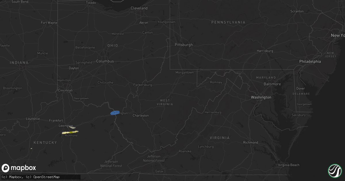
Hail Map in West Virginia on February 28, 2024
Get this storm
February 28 map
$229
one time, instant access
Download today. No call, no setup
Keep the $229
Bought the map and want the full workflow? Apply the entire $229 to a subscription within 7 days. None of it is wasted.
Every map, not just this one
This buys you this map. Subscription and you get every map we run, in the markets you choose from a few cities to whole states to nationwide. Plus real-time alerts the moment a storm fires.
Contact data
Name, contact info, occupancy, even credit band for addresses in the footprint. You go from where it hit to who to call.
Become the source they trust
Unlimited branding weather history reports on demand. You already have the documented answer ready for the property owner, and you are the one who showed up with it.
Property data and RoofTrace estimates
Pull up any address you have got, its value and the exact code rules for that jurisdiction, straight from One Click Code. Then RoofTrace estimates the squares, pitch, and roof value, priced the way you price.
Storm reports in West Virginia
West Virginia
| Date | Description |
|---|---|
| 02/28/202410:30 AM CST | Tree reported down on coal heritage road blocking both lanes. |
| 02/28/202410:30 AM CST | There are 2 trees down in elbert at the 39 load out. The trees are blocking both lanes of traffic. |
| 02/28/202410:16 AM CST | Tree down partially blocking the road at 2220 teter rd... Buckannon. |
| 02/28/20249:12 AM CST | Corrects previous tstm wnd dmg report from 5 wnw audra state park. Tree down partially blocking the road at 2220 teter rd... Buckannon. |
| 02/28/20248:05 AM CST | Tree down blocking the right side of the road due to high wind. |
| 02/28/20248:00 AM CST | Tree fell across the line... Snapped the pole. |
| 02/28/20247:59 AM CST | Tree down on scott depot rd. U.s. 60 in scott depot. |
| 02/28/20247:30 AM CST | Tree down between foreman drive and gabe road. |
| 02/28/20247:28 AM CST | Tree reported down blocking hazelgreen road. |
| 02/28/20246:50 AM CST | Emergency management reported down trees on roadway. Time estimated based on radar. |
| 02/28/20246:44 AM CST | Dot reported downed trees in moundsville. Time estimated based on radar. |
| 02/28/20246:44 AM CST | Emergency management reported down trees on roadway. Time estimated based on radar. |
| 02/28/20246:42 AM CST | Emergency management reported down trees on roadway. Time estimated based on radar. |
| 02/28/20246:41 AM CST | Emergency management reported down trees on roadway. Time estimated based on radar. |
| 02/28/20246:40 AM CST | Emergency management reported down trees on roadway. Time estimated based on radar. |
| 02/28/20246:40 AM CST | Emergency management reported down trees on roadway. Time estimated based on radar. |
All States Impacted by Hail Map on February 28, 2024
Cities Impacted by Hail Map on February 28, 2024
- Three Oaks, MI
- Sawyer, MI
- Buchanan, MI
- New Troy, MI
- Bridgman, MI
- Baroda, MI
- Dowagiac, MI
- Decatur, MI
- Hawesville, KY
- Philpot, KY
- Reynolds Station, KY
- Richmond, KY
- Lexington, KY
- Nicholasville, KY
- Ashland, KY
- Catlettsburg, KY
- Chesapeake, OH
- Ironton, OH
- South Point, OH
- Kenova, WV
- Huntington, WV
- Ceredo, WV
- Argillite, KY
- Winchester, KY
- Waco, KY
- Muscle Shoals, AL
- Tuscumbia, AL
- Leighton, AL
- Town Creek, AL
- Kingston, TN
- Loudon, TN
- Lenoir City, TN
- Farragut, TN
- Louisville, TN
- Friendsville, TN
- Knoxville, TN
- Rockford, TN
- Alcoa, TN
- Maryville, TN
- Seymour, TN
- Clay City, KY
- Lancaster, KY
- Magnolia, KY
- Sevierville, TN
- Atlanta, GA
- Norcross, GA
- Lilburn, GA
- Tucker, GA
- Stone Mountain, GA
- Union, SC
- Buffalo, SC


