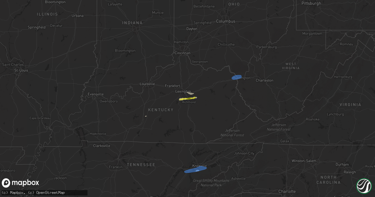
Hail Map on February 28, 2024
Get this storm
February 28 map
$229
one time, instant access
Download today. No call, no setup
Keep the $229
Bought the map and want the full workflow? Apply the entire $229 to a subscription within 7 days. None of it is wasted.
Every map, not just this one
This buys you this map. Subscription and you get every map we run, in the markets you choose from a few cities to whole states to nationwide. Plus real-time alerts the moment a storm fires.
Contact data
Name, contact info, occupancy, even credit band for addresses in the footprint. You go from where it hit to who to call.
Become the source they trust
Unlimited branding weather history reports on demand. You already have the documented answer ready for the property owner, and you are the one who showed up with it.
Property data and RoofTrace estimates
Pull up any address you have got, its value and the exact code rules for that jurisdiction, straight from One Click Code. Then RoofTrace estimates the squares, pitch, and roof value, priced the way you price.
States Impacted by Hail Map on February 28, 2024
Storm reports
South Carolina
| Date | Description |
|---|---|
| 02/28/20245:37 PM CST | Sc dot reported tree down in roadway near porter road and highway 1. Time estimated by radar. |
| 02/28/20245:35 PM CST | Richland county em reported trees down on powerlines along valkill court. Time estimated by radar. ( |
| 02/28/20245:35 PM CST | Richland county em reported trees down on powerlines along valkill court. Time estimated by radar. |
| 02/28/20245:28 PM CST | Columbia richland fire dept reported power lines falling on a vehicle. Time estimated by radar. |
| 02/28/20245:26 PM CST | Nws employee reported large limbs down blocking road on railroad avenue. Time estimated by radar. |
| 02/28/20245:22 PM CST | Sc dot reported down in roadway on j c trapp road. Time estimated by radar. |
| 02/28/20245:22 PM CST | Corrects previous tstm wnd dmg report from 5 ssw blythewood. Sc dot reported tree down in roadway on j c trapp road. Time estimated by radar. |
| 02/28/20245:21 PM CST | Sc dot reported a tree in roadway at blythewood road and fulmer road. Time estimated by radar. |
| 02/28/20245:00 PM CST | Sc dot reported powerlines down in roadway at padgetts pond road and rugged hill road. |
| 02/28/20244:07 PM CST | Sc dot reported tree in roadway at flint hill road and jalapa road. Time estimated by radar. |
| 02/28/20244:07 PM CST | Dispatch reported a tree down at moss ave and james speed rd. |
| 02/28/20243:50 PM CST | Trees and power lines down across chester county. |
| 02/28/20243:35 PM CST | A local report indicates 58 MPH wind near 3 SSW Union |
| 02/28/20243:30 PM CST | Tree down on hawkins rd. |
| 02/28/20243:25 PM CST | Tree fell on a power line on rice ave. |
| 02/28/20243:22 PM CST | Tree in roadway on meansville rd. |
| 02/28/20243:20 PM CST | A few trees blown down with one falling on a power line generally near laurens. |
| 02/28/20243:20 PM CST | Tree down on cross keys hwy. |
| 02/28/20243:19 PM CST | Tree across bridge on vaughn rd. |
| 02/28/20243:15 PM CST | Tree down on forest street. |
| 02/28/20243:15 PM CST | Downed power lines caused a fire on proctor rd. |
| 02/28/20243:07 PM CST | Tree down on old factory road. |
| 02/28/20243:05 PM CST | Tree in roadway on gaffney hwy. |
| 02/28/20242:55 PM CST | Tree down on a house on betsy ln. |
| 02/28/20242:50 PM CST | Roof blew off a mobile home. |
| 02/28/20242:46 PM CST | Tree down near broadway school road and herman brooks road. |
| 02/28/20242:45 PM CST | Tree down on gas plant road. |
| 02/28/20242:43 PM CST | Tree down on bethlehem church road. |
| 02/28/20242:40 PM CST | Tree and power line down on stone drive. |
| 02/28/20242:30 PM CST | Trees down on brockman mcclimon rd and liberty hill rd. |
| 02/28/20242:28 PM CST | Tree down near blackman road martin lane. |
| 02/28/20242:25 PM CST | Tree down on hopkins road. |
| 02/28/20242:22 PM CST | A local report indicates 59 MPH wind near 1 ENE Downtown Greenvil |
| 02/28/20242:20 PM CST | Downed power lines due to wind. |
| 02/28/20242:15 PM CST | Tree down on old pendleton road. |
| 02/28/20242:12 PM CST | A few trees down along old easley highway near the pickens/greenville county line. |
Alabama
| Date | Description |
|---|---|
| 02/28/202411:00 AM CST | Roof partially blown off a barn on burton drive in henagar. Time estimated from radar. |
| 02/28/202410:58 AM CST | Small portion of a tin roof partially off a church. Time estimated from radar. |
| 02/28/202410:47 AM CST | Tree reported down and blocking the road along highway 35 in section. |
| 02/28/202410:42 AM CST | Corrects previous tstm wnd dmg report from 3 nnw langston. Several trees reported down along skyline shores drive. |
| 02/28/202410:14 AM CST | Roof blown off a barn off of green briar cove rd in morgan city. Time estimated by radar. |
| 02/28/20249:53 AM CST | The roof of a large barn was heavily damaged at this location. |
| 02/28/20249:46 AM CST | 60 mph winds were reported at this location by a trained spotter. |
| 02/28/20249:45 AM CST | Power line reported down on a vehicle along pulaski pike and reynolds road. |
| 02/28/20249:42 AM CST | Several trees reported down along skyline shores drive. |
| 02/28/20249:36 AM CST | Power poles reported down along morris road in toney. |
| 02/28/20248:48 AM CST | A tree was reported down at this location near 8180 old highway 20. |
| 02/28/20248:43 AM CST | Power line reported down or leaning along spring valley road. |
| 02/28/20248:40 AM CST | A tree was reported down near the intersection of gate 6 road and 2nd street. |
| 02/28/20248:38 AM CST | The kmsl asos reported a 61 mph gust. |
| 02/28/20248:22 AM CST | A tree was reported down at this location near 2903 mulberry lane. |
| 02/28/20248:17 AM CST | Trees and power lines reported down along riverton rose trail. One person trapped in a vehicle. |
| 02/28/20247:48 AM CST | Multiple trees and a power pole down on riverton rose trace which is nw of cherokee community and near the tva campground. A power pole fell on a vehicle temporarily tr |
Georgia
| Date | Description |
|---|---|
| 02/28/20245:00 PM CST | Columbia county dispatch reported trees on powerlines at crawford place and haire baxton road. Time estimated by radar. |
| 02/28/20245:00 PM CST | Columbia county dispatch reported trees on powerlines at clarks hill road and petersburg road. Time estimated by radar. |
| 02/28/20243:45 PM CST | Uga mesonet station uga49 covington. |
| 02/28/20243:40 PM CST | Tree down near the intersection of stevens grove church rd and palmer rd. |
| 02/28/20243:30 PM CST | Tree down near the intersection of wolfskin rd and athens rd. |
| 02/28/20243:22 PM CST | Tree down along nunnally shoals rd near old monroe madison hwy. |
| 02/28/20243:15 PM CST | Tree down across hwy 92 at peeples road. All lanes blocked. |
| 02/28/20243:15 PM CST | Tree down on norton rd between barnett shoals rd and williamsburg pl. |
| 02/28/20242:53 PM CST | Report of a tree downed along i85 near the sharpsburg-mccollum rd exit. |
| 02/28/20242:50 PM CST | Tree down... Blocking one lane of traffic on hwy 78 near the intersection of cown rd. |
| 02/28/20242:46 PM CST | Tree down at the intersection of center hill church rd and mccullers rd. |
| 02/28/20242:41 PM CST | Power lines damaged at the intersection of xavier ray ct sw and lenna dr sw. |
| 02/28/20242:40 PM CST | A few trees downed with one on power lines. No specific area but generally near hartwell. |
| 02/28/20242:35 PM CST | Powerlines down near the intersection of i285 and memorial dr. |
| 02/28/20242:33 PM CST | Tree reported down on a home on white cir sw. |
| 02/28/20242:31 PM CST | Tree down on powerlines... Which started a brush fire... On old fountain rd ne. |
| 02/28/20242:29 PM CST | Tree reported down near the intersection of braselton hwy and old fountain rd. |
| 02/28/20242:27 PM CST | Tree down near the intersection of fort daniels dr ne and auburn rd. |
| 02/28/20242:26 PM CST | Measured gust from peachtree-dekalb |
| 02/28/20242:26 PM CST | A few trees down with at least 2 falling on power lines generally near carnesville. |
| 02/28/20242:25 PM CST | Tree down on powerlines near the intersection of duluth hwy and sever rd. |
| 02/28/20242:23 PM CST | Tree reported down near the intersection of stoneview dr sw and bailey dr sw. |
| 02/28/20242:22 PM CST | Tree down near the intersection of buford dr and gravel springs rd. |
| 02/28/20242:20 PM CST | Tree reported down on a house on millerbrook dr. Nw. |
| 02/28/20242:20 PM CST | Tree and wires reported down in the road on rolling way nw. |
| 02/28/20242:19 PM CST | Tree down at the intersection of oneta dr and williams rd. |
| 02/28/20242:15 PM CST | Tree downed along gillsville hwy just east of suggs road. |
| 02/28/20242:15 PM CST | Weather station dw1905 atlanta. |
| 02/28/20242:13 PM CST | Tree reported down near the intersection of governors lake pkwy nw and jones mill rd nw. |
| 02/28/20242:13 PM CST | Tree down near the intersection of jones mill rd and bay cir. |
| 02/28/20242:10 PM CST | Tree downed along atlanta hwy at gaines ferry road. |
| 02/28/20242:08 PM CST | A few small trees downed near blackstock rd. |
| 02/28/20241:53 PM CST | Four trees down north of highway 92 and south of arnold mill rd... Between neese rd and wiley bridge rd. |
| 02/28/20241:50 PM CST | Tree down and blocking the roadway near the intersection of stonechat ct. And mabry rd ne. |
| 02/28/20241:50 PM CST | Tree down on osco parkway. |
| 02/28/20241:47 PM CST | Tree down in woodstock park near dupree rd. |
| 02/28/20241:45 PM CST | Tree down at brookwood dr and alabama rd. |
| 02/28/20241:43 PM CST | Damage to an outdoor structure...the roof of a baseball dugout was blown off. |
| 02/28/20241:40 PM CST | Tree down along ball ground road just south of george mcclure lane. |
| 02/28/20241:40 PM CST | Trees and powerlines down at the intersection of edwards mill road and newt green road. |
| 02/28/20241:35 PM CST | Trees down at the intersection of pearidge rd and pine grove road. |
| 02/28/20241:35 PM CST | Several reports of trees down around canton ga. Pearidge rd and pine grove rd... Marietta rd and bells ferry rd... York dr... N brooke dr and river estates pkwy... And |
| 02/28/20241:35 PM CST | Corrects previous tstm wnd dmg report from 1 ne dallas. Fallen tree near the intersection of croker rd and e memorial dr. |
| 02/28/20241:35 PM CST | Tree down along marble quarry rd and crestmont dr. |
| 02/28/20241:30 PM CST | Four reports of trees down near the town of lathemtown... Between cumming hwy... Along ball ground rd... And near new green rd and edwards mill rd intersection. |
| 02/28/20241:30 PM CST | Fallen tree near the intersection of croker rd and e memorial dr. |
| 02/28/20241:30 PM CST | A few trees down near the intersection of croker rd and old acworth rd. |
| 02/28/20241:30 PM CST | Large tree limbs and branches down greater than 2 inches in diameter near intersection of sr-140 and waleska road. Estimated wind gusts to 50 mph. |
| 02/28/20241:25 PM CST | Four reports of trees down along fincher rd between broad water bay rd and reinhardt college parkway. |
| 02/28/20241:05 PM CST | Trees reported down near the intersection of blanche rd and cherokee cir. |
| 02/28/20241:00 PM CST | Trees down along judkin mill road. |
| 02/28/20241:00 PM CST | Trees reported down near the intersection of n 6th street and seab green rd. |
| 02/28/20241:00 PM CST | Trees reported down along old mill rd. |
| 02/28/202411:15 AM CST | Trees and powerlines down and trees reported on homes north of warthen st in north lafayette. |
West Virginia
| Date | Description |
|---|---|
| 02/28/202410:30 AM CST | There are 2 trees down in elbert at the 39 load out. The trees are blocking both lanes of traffic. |
| 02/28/202410:30 AM CST | Tree reported down on coal heritage road blocking both lanes. |
| 02/28/202410:16 AM CST | Tree down partially blocking the road at 2220 teter rd... Buckannon. |
| 02/28/20249:12 AM CST | Corrects previous tstm wnd dmg report from 5 wnw audra state park. Tree down partially blocking the road at 2220 teter rd... Buckannon. |
| 02/28/20248:05 AM CST | Tree down blocking the right side of the road due to high wind. |
| 02/28/20248:00 AM CST | Tree fell across the line... Snapped the pole. |
| 02/28/20247:59 AM CST | Tree down on scott depot rd. U.s. 60 in scott depot. |
| 02/28/20247:30 AM CST | Tree down between foreman drive and gabe road. |
| 02/28/20247:28 AM CST | Tree reported down blocking hazelgreen road. |
| 02/28/20246:50 AM CST | Emergency management reported down trees on roadway. Time estimated based on radar. |
| 02/28/20246:44 AM CST | Emergency management reported down trees on roadway. Time estimated based on radar. |
| 02/28/20246:44 AM CST | Dot reported downed trees in moundsville. Time estimated based on radar. |
| 02/28/20246:42 AM CST | Emergency management reported down trees on roadway. Time estimated based on radar. |
| 02/28/20246:41 AM CST | Emergency management reported down trees on roadway. Time estimated based on radar. |
| 02/28/20246:40 AM CST | Emergency management reported down trees on roadway. Time estimated based on radar. |
| 02/28/20246:40 AM CST | Emergency management reported down trees on roadway. Time estimated based on radar. |
Mississippi
| Date | Description |
|---|---|
| 02/28/20248:02 AM CST | Multiple trees down along mt vernon road. |
Ohio
| Date | Description |
|---|---|
| 02/28/20246:30 AM CST | Dot reported a downed tree along state route 148 through armstrongs mills. Time estimated based on radar. |
| 02/28/20246:28 AM CST | Report and photos of damage to barn along pugh ridge road. Time estimated based on radar. |
| 02/28/20246:27 AM CST | Dot reported tree down along us 250 near harrisville. Time estimated based on radar. |
| 02/28/20246:26 AM CST | Dot reports multiple trees down around beallsville. Time estimated based on radar. |
| 02/28/20246:25 AM CST | Nws pittsburgh... Pa storm survey team found ef2 storm damage in malaga township in monroe county... Oh. Maximum wind gust was estimated at 120mph along state route 800 |
| 02/28/20246:24 AM CST | Dot reporting multiple trees down along state route 26 through ozark. Time estimated based on radar. |
| 02/28/20246:20 AM CST | Emergency management reporting multiple barns destroyed... Roofs blown off and power line issues around ozark in the southwest corner of sunsbury township. Time estimat |
| 02/28/20246:20 AM CST | Multiple lines down blocking county road 1. |
| 02/28/20246:20 AM CST | Public report picture showing multiple trees blown over along county road 2 in monroe county. Time estimated based on radar. |
| 02/28/20246:20 AM CST | Public picture showing a line trees completely uprooted with a couple others pine snapped. Time estimated based on radar. |
| 02/28/20246:06 AM CST | Dot reported downed tree along state route 799 at the 5 mile marker near freeport. Time estimated based on radar. |
New York
| Date | Description |
|---|---|
| 02/28/20244:57 PM CST | Tree down on wires on woodside ave. |
| 02/28/20244:23 PM CST | Several trees down in front of home in castle creek. |
| 02/28/20244:22 PM CST | Tree down across brooks rd along with chimney knocked off roof. |
| 02/28/20244:20 PM CST | Damage survey confirmed ef1 tornado just south of the hamlet of castle creek in the intersection of brooks rd and route 11. Numerous large trees were uprooted and snapp |
| 02/28/20244:20 PM CST | Tree down in yard on east maine near the town of maine. |
| 02/27/20246:54 PM CST | Upper turnpike rd... Whitehall...tree down. |
Tennessee
| Date | Description |
|---|---|
| 02/28/202411:45 AM CST | Multiple reports of trees down across the community. |
| 02/28/202411:42 AM CST | Reported by trained spotter. Structural posts used to extend the height of a fence post have been broken/bent. |
| 02/28/202411:37 AM CST | Reported by trained spotter. 3 ne church hill - personal weather station |
| 02/28/202411:23 AM CST | Asos station ktys knoxville mcghee tyson. |
| 02/28/202411:05 AM CST | Numerous trees and power lines down across the county. |
| 02/28/202411:05 AM CST | Mcgee blvd @rock springs rd...trees and 3 power poles down behind mcdonalds. |
Pennsylvania
| Date | Description |
|---|---|
| 02/28/20247:45 AM CST | Photo of large pine down on lincoln street. Time estimated based on radar. |
| 02/28/20247:28 AM CST | Report of tree blown down on house with no injuries. Time estimated based on radar. |
| 02/28/20247:23 AM CST | Report of trees knocking electrical wires down onto the road. Tree is also blocking mohr road. Time estimated based on radar. |
| 02/28/20247:15 AM CST | Dot reporting downed trees over much of greene county. Location and time estimated based on radar. |
| 02/28/20247:15 AM CST | Dot reporting downed trees over much of greene county. Location and time estimated based on radar. |
| 02/28/20247:13 AM CST | Report of tree down blocking one lane of state route 21 just west of oak forest road. Time estimated based on radar. |
| 02/28/20247:01 AM CST | Dot reporting downed trees over much of greene county. Location and time estimated based on radar. |
Virginia
| Date | Description |
|---|---|
| 02/28/202412:00 PM CST | Tree down at the intersection of reedy creek rd... And pairgin rd. |
Kentucky
| Date | Description |
|---|---|
| 02/28/20242:36 PM CST | Delayed report. Several large trees uprooted on old leitchfield road east of whitesville. Time estimated by radar. |
| 02/28/20248:31 AM CST | A thunderstorm wind gust of 67 mph was measured by the asos at the london-corbin airport this morning. |
| 02/28/20247:30 AM CST | Tree down. |
| 02/28/20247:30 AM CST | Corrects previous tstm wnd dmg report from 2 se pitts. Tree down at 265 cobhill road. |
| 02/28/20247:25 AM CST | Tree down on doe creek road. |
| 02/28/20247:25 AM CST | Damage to greenhouse. Time is estimated from radar. |
| 02/28/20247:23 AM CST | Carport blown down and a few trees down. One tree down on a vehicle. Nearby personal weather station had a 47 mph gust. Time estimated from radar. |
| 02/28/20247:05 AM CST | Delayed report. Tree down at wilgreen lake rd. |
| 02/28/20247:03 AM CST | Tree down on loop road. |
| 02/28/20247:03 AM CST | Tree down on north us 127. |
| 02/28/20246:42 AM CST | Tree blown down at the intersection of robin hood drive and knapp avenue. |
| 02/28/20246:25 AM CST | Tree down near us 150. |
| 02/28/20246:23 AM CST | A local report indicates 1.25 inch wind near Winchester |
| 02/28/20246:20 AM CST | Large tree limbs down near home. |
| 02/28/20246:18 AM CST | Barn down at route 11/van thompson road. |
| 02/28/20246:15 AM CST | A local report indicates 61 MPH wind near Ashland |
| 02/28/20246:06 AM CST | A local report indicates 1.00 inch wind near 4 NNE Keene |
North Carolina
| Date | Description |
|---|---|
| 02/28/20243:51 PM CST | Report from mping of trees uprooted or snapped near the intersection of pope rd and swaim rd. Time estimated by radar. |
| 02/28/20243:51 PM CST | Report from mping of trees uprooted or snapped near the intersection of w clemmonsville rd and berchfield dr. Time estimated by radar. |
| 02/28/20243:51 PM CST | Report from mping of trees uprooted or snapped southeast of the parklawn memorial gardens. |
| 02/28/20243:33 PM CST | Several trees down along concord church rd... Williams rd... And styers ferry rd. Time |
| 02/28/20243:33 PM CST | Several trees down along concord church rd... Williams rd... And styers ferry rd. Time estimated based on radar. |
| 02/28/20243:19 PM CST | Tree down on current road. |
| 02/28/202412:55 PM CST | A few trees were downed by the high wind as the line of storms passed through. |
Cities Impacted by Hail Map on February 28, 2024
- Three Oaks, MI
- Sawyer, MI
- Buchanan, MI
- New Troy, MI
- Bridgman, MI
- Baroda, MI
- Dowagiac, MI
- Decatur, MI
- Hawesville, KY
- Philpot, KY
- Reynolds Station, KY
- Richmond, KY
- Lexington, KY
- Nicholasville, KY
- Ashland, KY
- Catlettsburg, KY
- Chesapeake, OH
- Ironton, OH
- South Point, OH
- Kenova, WV
- Huntington, WV
- Ceredo, WV
- Argillite, KY
- Winchester, KY
- Waco, KY
- Muscle Shoals, AL
- Tuscumbia, AL
- Leighton, AL
- Town Creek, AL
- Kingston, TN
- Loudon, TN
- Lenoir City, TN
- Farragut, TN
- Louisville, TN
- Friendsville, TN
- Knoxville, TN
- Rockford, TN
- Alcoa, TN
- Maryville, TN
- Seymour, TN
- Clay City, KY
- Lancaster, KY
- Magnolia, KY
- Sevierville, TN
- Atlanta, GA
- Norcross, GA
- Lilburn, GA
- Tucker, GA
- Stone Mountain, GA
- Union, SC
- Buffalo, SC