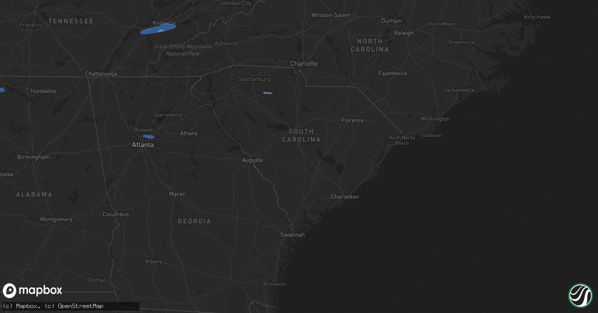
Hail Map in South Carolina on February 28, 2024
Get this storm
February 28 map
$229
one time, instant access
Download today. No call, no setup
Keep the $229
Bought the map and want the full workflow? Apply the entire $229 to a subscription within 7 days. None of it is wasted.
Every map, not just this one
This buys you this map. Subscription and you get every map we run, in the markets you choose from a few cities to whole states to nationwide. Plus real-time alerts the moment a storm fires.
Contact data
Name, contact info, occupancy, even credit band for addresses in the footprint. You go from where it hit to who to call.
Become the source they trust
Unlimited branding weather history reports on demand. You already have the documented answer ready for the property owner, and you are the one who showed up with it.
Property data and RoofTrace estimates
Pull up any address you have got, its value and the exact code rules for that jurisdiction, straight from One Click Code. Then RoofTrace estimates the squares, pitch, and roof value, priced the way you price.
Storm reports in South Carolina
South Carolina
| Date | Description |
|---|---|
| 02/28/20245:37 PM CST | Sc dot reported tree down in roadway near porter road and highway 1. Time estimated by radar. |
| 02/28/20245:35 PM CST | Richland county em reported trees down on powerlines along valkill court. Time estimated by radar. ( |
| 02/28/20245:35 PM CST | Richland county em reported trees down on powerlines along valkill court. Time estimated by radar. |
| 02/28/20245:28 PM CST | Columbia richland fire dept reported power lines falling on a vehicle. Time estimated by radar. |
| 02/28/20245:26 PM CST | Nws employee reported large limbs down blocking road on railroad avenue. Time estimated by radar. |
| 02/28/20245:22 PM CST | Corrects previous tstm wnd dmg report from 5 ssw blythewood. Sc dot reported tree down in roadway on j c trapp road. Time estimated by radar. |
| 02/28/20245:22 PM CST | Sc dot reported down in roadway on j c trapp road. Time estimated by radar. |
| 02/28/20245:21 PM CST | Sc dot reported a tree in roadway at blythewood road and fulmer road. Time estimated by radar. |
| 02/28/20245:00 PM CST | Sc dot reported powerlines down in roadway at padgetts pond road and rugged hill road. |
| 02/28/20244:07 PM CST | Dispatch reported a tree down at moss ave and james speed rd. |
| 02/28/20244:07 PM CST | Sc dot reported tree in roadway at flint hill road and jalapa road. Time estimated by radar. |
| 02/28/20243:50 PM CST | Trees and power lines down across chester county. |
| 02/28/20243:35 PM CST | A local report indicates 58 MPH wind near 3 SSW Union |
| 02/28/20243:30 PM CST | Tree down on hawkins rd. |
| 02/28/20243:25 PM CST | Tree fell on a power line on rice ave. |
| 02/28/20243:22 PM CST | Tree in roadway on meansville rd. |
| 02/28/20243:20 PM CST | Tree down on cross keys hwy. |
| 02/28/20243:20 PM CST | A few trees blown down with one falling on a power line generally near laurens. |
| 02/28/20243:19 PM CST | Tree across bridge on vaughn rd. |
| 02/28/20243:15 PM CST | Downed power lines caused a fire on proctor rd. |
| 02/28/20243:15 PM CST | Tree down on forest street. |
| 02/28/20243:07 PM CST | Tree down on old factory road. |
| 02/28/20243:05 PM CST | Tree in roadway on gaffney hwy. |
| 02/28/20242:55 PM CST | Tree down on a house on betsy ln. |
| 02/28/20242:50 PM CST | Roof blew off a mobile home. |
| 02/28/20242:46 PM CST | Tree down near broadway school road and herman brooks road. |
| 02/28/20242:45 PM CST | Tree down on gas plant road. |
| 02/28/20242:43 PM CST | Tree down on bethlehem church road. |
| 02/28/20242:40 PM CST | Tree and power line down on stone drive. |
| 02/28/20242:30 PM CST | Trees down on brockman mcclimon rd and liberty hill rd. |
| 02/28/20242:28 PM CST | Tree down near blackman road martin lane. |
| 02/28/20242:25 PM CST | Tree down on hopkins road. |
| 02/28/20242:22 PM CST | A local report indicates 59 MPH wind near 1 ENE Downtown Greenvil |
| 02/28/20242:20 PM CST | Downed power lines due to wind. |
| 02/28/20242:15 PM CST | Tree down on old pendleton road. |
| 02/28/20242:12 PM CST | A few trees down along old easley highway near the pickens/greenville county line. |
All States Impacted by Hail Map on February 28, 2024
Cities Impacted by Hail Map on February 28, 2024
- Three Oaks, MI
- Sawyer, MI
- Buchanan, MI
- New Troy, MI
- Bridgman, MI
- Baroda, MI
- Dowagiac, MI
- Decatur, MI
- Hawesville, KY
- Philpot, KY
- Reynolds Station, KY
- Richmond, KY
- Lexington, KY
- Nicholasville, KY
- Ashland, KY
- Catlettsburg, KY
- Chesapeake, OH
- Ironton, OH
- South Point, OH
- Kenova, WV
- Huntington, WV
- Ceredo, WV
- Argillite, KY
- Winchester, KY
- Waco, KY
- Muscle Shoals, AL
- Tuscumbia, AL
- Leighton, AL
- Town Creek, AL
- Kingston, TN
- Loudon, TN
- Lenoir City, TN
- Farragut, TN
- Louisville, TN
- Friendsville, TN
- Knoxville, TN
- Rockford, TN
- Alcoa, TN
- Maryville, TN
- Seymour, TN
- Clay City, KY
- Lancaster, KY
- Magnolia, KY
- Sevierville, TN
- Atlanta, GA
- Norcross, GA
- Lilburn, GA
- Tucker, GA
- Stone Mountain, GA
- Union, SC
- Buffalo, SC


