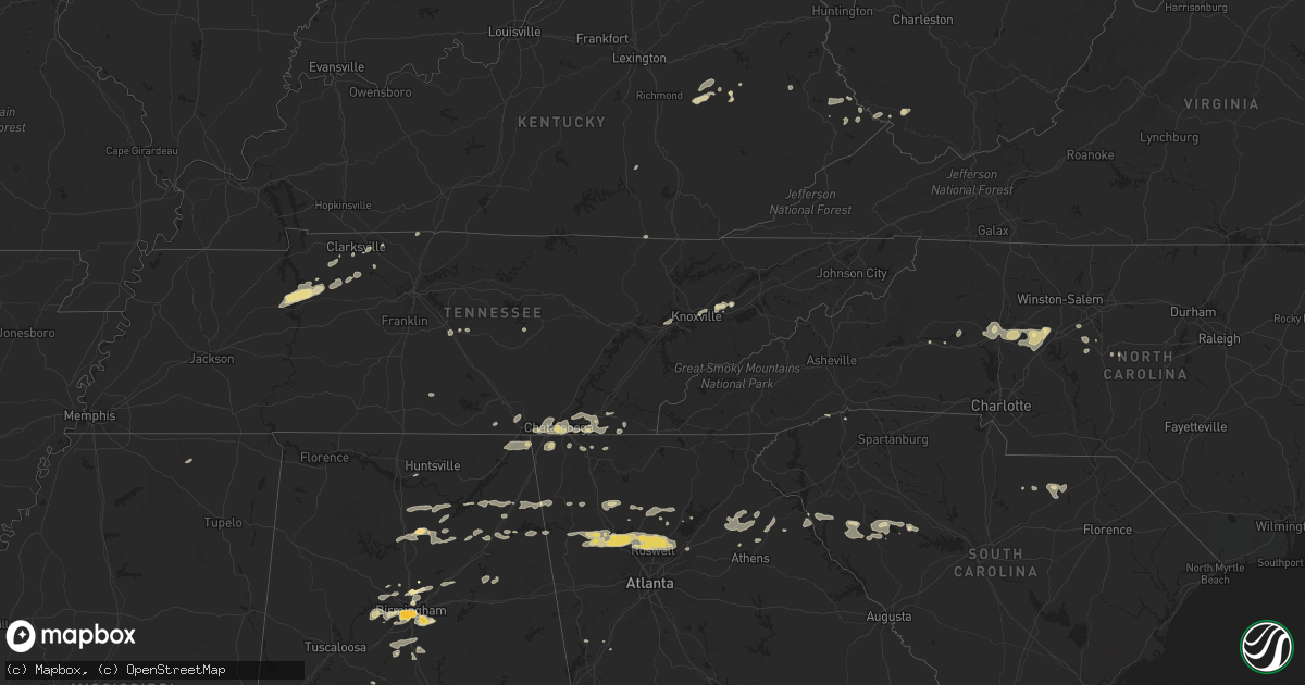
Hail Map in Georgia on February 28, 2011
Get this storm
February 28 map
$229
one time, instant access
Download today. No call, no setup
Keep the $229
Bought the map and want the full workflow? Apply the entire $229 to a subscription within 7 days. None of it is wasted.
Every map, not just this one
This buys you this map. Subscription and you get every map we run, in the markets you choose from a few cities to whole states to nationwide. Plus real-time alerts the moment a storm fires.
Contact data
Name, contact info, occupancy, even credit band for addresses in the footprint. You go from where it hit to who to call.
Become the source they trust
Unlimited branding weather history reports on demand. You already have the documented answer ready for the property owner, and you are the one who showed up with it.
Property data and RoofTrace estimates
Pull up any address you have got, its value and the exact code rules for that jurisdiction, straight from One Click Code. Then RoofTrace estimates the squares, pitch, and roof value, priced the way you price.
Storm reports in Georgia
Georgia
| Date | Description |
|---|---|
| 02/28/20115:25 PM CST | Bartow county ema relayed a report of many trees down in adairsville. |
| 02/28/20115:20 PM CST | Metal roof blown off building |
| 02/28/20115:16 PM CST | Trees down from dewy rose to rockbranch |
| 02/28/20115:12 PM CST | Tree down along highway 172 |
| 02/28/20115:08 PM CST | Tree down in goldmine area |
| 02/28/20115:00 PM CST | Tree down |
| 02/28/20114:52 PM CST | Madison county 911 relayed reports of widespread tree damage in the county. More than a dozen trees were downed. |
| 02/28/20114:52 PM CST | Public reported quarter sized hail. |
| 02/28/20114:45 PM CST | The 911 center of gwinnett county reported a tree down on a house in lawrenceville on guardian way. |
| 02/28/20114:37 PM CST | Public reported a couple of trees down in winder. |
| 02/28/20114:25 PM CST | Banks county emergency management reported multiple downed trees. A storage shed and store signs were blown onto us 441. |
| 02/28/20114:25 PM CST | Banks county emergency management relayed reports that downtown maysville had power out. |
| 02/28/20114:15 PM CST | Spotter reported 1.25 inch diameter hail in roswell. |
| 02/28/20113:57 PM CST | Cherokee county emergency management relayed reports downed trees and powerlines south of canton. |
| 02/28/20113:57 PM CST | Trained spotter reported quarter sized hail in kennesaw near i-575 and bells ferry. |
| 02/28/20113:55 PM CST | Cherokee county emergency management relayed a report of half dollar sized hail. |
| 02/28/20113:54 PM CST | Cherokee county emergency management relayed reports on 6 downed trees and power lines in woodstock. |
| 02/28/20113:53 PM CST | Amateur radio relayed reports of structure damage. The back wall of a building was blown down on cherokee drive. |
| 02/28/20113:50 PM CST | Public reported quarter to half dollar sized hail. |
| 02/28/20113:48 PM CST | Cherokee county emergency management reports power outages in most of woodstock. |
| 02/28/20113:44 PM CST | Public reported measuring a gust of 62 mph and a wind of 28 mph with an anemometer on the pickens-dawson county line. |
| 02/28/20113:39 PM CST | Cherokee county emergency management reported several downed pine trees. |
| 02/28/20113:35 PM CST | Bartow county ema relayed a report of many trees down in the cartersville area. |
| 02/28/20113:15 PM CST | Spotter reported 1.25 inch diameter hail in roswell. |
| 02/28/20113:15 PM CST | Public reported a flagpole snapped by strong winds west of cave spring near the georgia-alabama border. |
| 02/28/20113:15 PM CST | Several trees down from sky valley southward |
| 02/28/20113:15 PM CST | Polk county 911 relayed a reports of a downed tree on highway 100 in cedartown. |
| 02/28/20113:00 PM CST | Bartow county ema relayed a report of many trees down in adairsville. |
| 02/28/20112:45 PM CST | The union county 911 center reports 3 power lines down. |
| 02/28/20112:44 PM CST | Towns county 911 relayed reports of over 9 trees downed in the county. Traffic lights were also reported out. |
| 02/28/20112:44 PM CST | Union county 911 relayed reports of over 20 trees down and 5 power lines down across the county. |
| 02/28/20112:30 PM CST | Fannin county 911 relayed reports of over 20 downed trees and 5 downed powerlines in the county. |
| 02/28/20112:10 PM CST | Murray county 911 relayed reports of 3 downed trees on highway 411 in northern murray county. |
| 02/28/20112:10 PM CST | Walker county emergency management relayed reports of over a dozen trees downed between chickamauga and rock spring in walker county. |
| 02/28/20112:10 PM CST | Emergency management in walker county reported quarter-sized hail between chickamagua and rock spring. |
| 02/28/20112:00 PM CST | Whitfield county 911 relayed report of 2 downed trees on houses in cohutta. |
| 02/28/20112:00 PM CST | Whitfield county emergency management reports several trees down on highway 71 just south of the georgia-tennessee border. |
| 02/28/20111:42 PM CST | Catoosa county 911 relayed reports of 3-4 trees down. |
| 02/28/20111:30 PM CST | Dade county 911 relayed reports of widespread downed trees in and around trenton. |
| 02/28/20111:30 PM CST | Dade county emergency management reports widespread tree damage in north dade county. Includes damage to 2 houses along highway 299 and in the pinecrest subdivision fro |
| 02/28/20111:30 PM CST | Walker county 911 relayed reports of downed power lines causing a power outage in rossville. |
| 02/28/20111:30 PM CST | Walker county 911 relayed reports of quarter sized hail around rossville. |
All States Impacted by Hail Map on February 28, 2011
Cities Impacted by Hail Map on February 28, 2011
- Erin, TN
- Dickson, TN
- McEwen, TN
- Vanleer, TN
- Groveoak, AL
- Geraldine, AL
- Albertville, AL
- Birmingham, AL
- Palmyra, TN
- Bessemer, AL
- Centre, AL
- Leesburg, AL
- Eva, TN
- Waverly, TN
- Camden, TN
- Big Sandy, TN
- Buford, GA
- Lawrenceville, GA
- Gardendale, AL
- Huntsville, AL
- Silverstreet, SC
- Collinsville, AL
- Cleveland, NC
- Athens, GA
- Jefferson, GA
- Fairmount, GA
- Rydal, GA
- Adairsville, GA
- Jasper, TN
- Cleveland, TN
- Chattanooga, TN
- Signal Mountain, TN
- McDonald, TN
- Ooltewah, TN
- Guild, TN
- Lookout Mountain, TN
- Harrison, TN
- Whitwell, TN
- Apison, TN
- Cumberland City, TN
- Smithville, TN
- Walling, TN
- Lexington, NC
- Pinson, AL
- Holly Pond, AL
- Cullman, AL
- Cooleemee, NC
- Salisbury, NC
- Woodleaf, NC
- Linwood, NC
- Advance, NC
- Mocksville, NC
- Sterrett, AL
- Dalton, GA
- Hanover, WV
- Gilbert, WV
- Simon, WV
- Roswell, GA
- Marietta, GA
- Rome, GA
- Aragon, GA
- Dallas, GA
- Cumming, GA
- Acworth, GA
- Suwanee, GA
- Alpharetta, GA
- Cartersville, GA
- Duluth, GA
- Lindale, GA
- Taylorsville, GA
- Kennesaw, GA
- Kingston, GA
- Silver Creek, GA
- Woodstock, GA
- Rockmart, GA
- Emerson, GA
- Canton, GA
- Dawsonville, GA
- Ball Ground, GA
- Campton, KY
- Danielsville, GA
- Royston, GA
- Waleska, GA
- McAndrews, KY
- Pinsonfork, KY
- Stone, KY
- Hanceville, AL
- Matewan, WV
- New Market, TN
- Cross Hill, SC
- Ninety Six, SC
- Greenwood, SC
- Stanton, KY
- Selma, AL
- Hodges, SC
- Abbeville, SC
- Leeds, AL
- Pikeville, KY
- Kimper, KY
- Raccoon, KY
- Guntersville, AL
- Arab, AL
- Union Grove, AL
- Petersburg, TN
- Marion, AL
- Minter, AL
- Sardis, AL
- South Pittsburg, TN
- Dora, AL
- Statesville, NC
- Falkville, AL
- Sophia, NC
- Stanton, AL
- Fultondale, AL
- Fairfield, AL
- Pleasant Grove, AL
- Mulga, AL
- Dolomite, AL
- Stewart, OH
- Athens, OH
- Guysville, OH
- Murfreesboro, TN
- Ringgold, GA
- Tunnel Hill, GA
- Morris, AL
- Columbiana, AL
- Iva, SC
- Starr, SC
- Bryant, AL
- Trussville, AL
- Mount Olive, AL
- Old Fort, TN
- Fort Payne, AL
- Dawson, AL
- Fyffe, AL
- Attalla, AL
- Boaz, AL
- Knoxville, TN
- Brent, AL
- Ravenna, KY
- Irvine, KY
- Elberton, GA
- Denton, NC
- Asheboro, NC
- Jefferson, SC
- McBee, SC
- Plainville, GA
- Adger, AL
- Trinity, NC
- Somerset, KY
- Strawberry Plains, TN
- Montevallo, AL
- Calera, AL
- Kimberly, AL
- Warrior, AL
- Bradley, SC
- Cave Spring, GA
- Hickory, NC
- Taylorsville, NC
- Lyerly, GA
- Clarksville, TN
- Adams, TN
- Armuchee, GA
- Cumberland Furnace, TN
- Alabaster, AL
- Rising Fawn, GA
- Chickamauga, GA
- Flintstone, GA
- Lookout Mountain, GA
- Rossville, GA
- Sherwood, TN
- Chatsworth, GA
- Waterloo, SC
- Chappells, SC
- Clay City, KY
- Grantville, GA
- Hazel Green, KY
- Springfield, TN
- Orlinda, TN
- Hartwell, GA
- Summerville, GA
- Travelers Rest, SC
- Kershaw, SC
- Strunk, KY
- Cunningham, TN
- Southside, TN
- Colbert, GA
- Hull, GA
- Prestonsburg, KY
- Pilgrim, KY
- Ohatchee, AL
- Alexandria, AL
- Gaylesville, AL
- Ragland, AL
- Jasper, GA
- Somerville, AL
- Eva, AL
- Baileyton, AL
- Joppa, AL
- Salyersville, KY
- Oil Springs, KY
- Brierfield, AL
- Readyville, TN
- Gainesville, GA
- White, GA
- Calhoun, GA
- Ripley, MS
- Gillsville, GA
- Pendergrass, GA
- Homer, GA
- Commerce, GA
- Maysville, GA
- Trenton, GA
- Stevenson, AL
- Flat Rock, AL
- Bridgeport, AL
- Wharncliffe, WV
- Belfry, KY
- Newberry, SC
- Mentone, AL
- Carnesville, GA
- Valdese, NC
- Horton, AL
- Altoona, AL
- Blountsville, AL
- Franklin, GA
- Graysville, AL
- Quinton, AL
- Adamsville, AL
- Chapmansboro, TN
- Ashland City, TN
- Ramseur, NC
- Ocoee, TN
- Kodak, TN
- Springville, AL
- Odenville, AL
- Slade, KY
- Hardy, KY
- Bowman, GA
- Thomasville, NC
- Gadsden, AL
- Cedar Mountain, NC
- Pelham, AL
- Helena, AL


