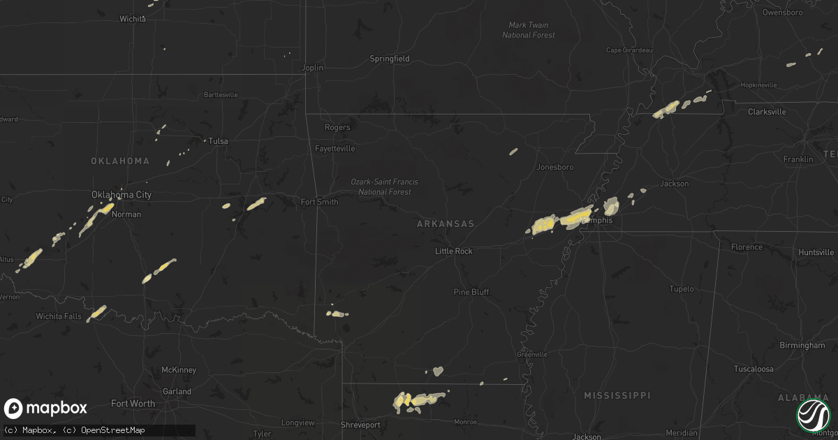
Hail Map in Tennessee on February 24, 2011
Get this storm
February 24 map
$229
one time, instant access
Download today. No call, no setup
Keep the $229
Bought the map and want the full workflow? Apply the entire $229 to a subscription within 7 days. None of it is wasted.
Every map, not just this one
This buys you this map. Subscription and you get every map we run, in the markets you choose from a few cities to whole states to nationwide. Plus real-time alerts the moment a storm fires.
Contact data
Name, contact info, occupancy, even credit band for addresses in the footprint. You go from where it hit to who to call.
Become the source they trust
Unlimited branding weather history reports on demand. You already have the documented answer ready for the property owner, and you are the one who showed up with it.
Property data and RoofTrace estimates
Pull up any address you have got, its value and the exact code rules for that jurisdiction, straight from One Click Code. Then RoofTrace estimates the squares, pitch, and roof value, priced the way you price.
Storm reports in Tennessee
Tennessee
| Date | Description |
|---|---|
| 02/24/20118:29 AM CST | House struck by lightning around 430 am. House located on butt road in north central sumner co. Reported by em mgr. |
| 02/24/20111:50 AM CST | Several trees down along cnty rd 500 |
| 02/24/20111:45 AM CST | Numerous trees down. |
| 02/24/20111:30 AM CST | Numerous trees down. |
| 02/24/20111:30 AM CST | Few trees down along route 307. |
| 02/24/20111:30 AM CST | Numerous trees down. |
| 02/24/20111:30 AM CST | Few trees down. |
| 02/24/20111:15 AM CST | Several trees down and a small carport blown over on conner drive. |
| 02/24/20111:15 AM CST | Several trees down. |
| 02/24/20111:12 AM CST | Five trees and two power lines down in and around knoxville. Reported by dispatch |
| 02/24/20111:00 AM CST | Several trees down. |
| 02/24/20111:00 AM CST | Few trees down. |
| 02/24/201112:45 AM CST | Several trees and numerous power lines down in and around chattanooga. Reported by dispatch. |
| 02/24/201112:42 AM CST | Two trees down in harriman. One tree down in rockwood. One tree down in oliver springs. Reported by dispatch. |
| 02/24/201112:30 AM CST | Two trees down and numerous power outages in dayton. Reorted by dispatch. |
| 02/24/201112:30 AM CST | Few trees down on whitwell mountain. |
| 02/24/201112:15 AM CST | Few trees down. |
| 02/24/201112:08 AM CST | Trees down. Event occurred between 1201am and 1216 am. No location given. |
| 02/24/201112:00 AM CST | Four trees down in and around dunlap. Reported by dispatch. |
| 02/23/201111:35 PM CST | Nashville tn wfo conducted a storm survey in pickett county tn and clinton county ky. The survey found that a microburst produced straight line winds of 80 mph and dama |
| 02/23/201111:35 PM CST | Reported trees down on lewisburg hwy. Damage reported to fayetteville public utilities. |
| 02/23/201111:34 PM CST | Trees down on highway 70 at sand springs just west of monterey |
| 02/23/201111:30 PM CST | Structural damage reported by public. No other details. |
| 02/23/201111:25 PM CST | Trees down on shelbyville hwy. Power outages reported in vann town area. |
| 02/23/201111:00 PM CST | Trees blown over into roads. Rpt from highway dept. |
| 02/23/201110:50 PM CST | A local report indicates 80 MPH wind near SMITHVILLE |
| 02/23/201110:31 PM CST | Tree reported on house near indian lake |
| 02/23/201110:25 PM CST | About 30 homes damaged by fallen trees across davidson county reported by police and fire officials. Hardest hit area is near percy priest lake. |
| 02/23/201110:25 PM CST | Large pine tree down and blocking one lane of shute lane. |
| 02/23/201110:25 PM CST | Trained spotter measured 80mph wind gust with home weather station. |
| 02/23/201110:21 PM CST | Numerous tree down and power outages. Water reported over highway 120. |
| 02/23/201110:14 PM CST | *** 2 inj *** an ef2 tornado occurred in lebanon with a maximum estimated wind speed of 120 mph...with a maximum path width of 150 yards...and a maximum path length of |
| 02/23/201110:06 PM CST | Trees down across jfk drive |
| 02/23/201110:02 PM CST | An ef2 tornado occurred in antioch with a maximum extimated wind speed of 120 mph with a maximum path width of 100 yards and a total path length of 7.5 miles. Damage be |
| 02/23/201110:01 PM CST | Substantial structural damage in the percy priest lake area. Two churches with roofs removed. Some two-story homes with significant damage to their upper story. No inju |
| 02/23/201110:00 PM CST | Public reported tornado near hickory hollow mall area near antioch. |
| 02/23/20119:58 PM CST | 4 inch tree down and estimated 65 mph winds |
| 02/23/20119:58 PM CST | Trees down near edmonson and macmurry and near harding |
| 02/23/20119:58 PM CST | Tree down on house on petway avenue in east nashville |
| 02/23/20119:50 PM CST | Hwy100/yellow creek road...numerous large trees down. |
| 02/23/20119:41 PM CST | Trees down crab creek road. Hwy100...transformer blown off poll. Power outages. |
| 02/23/20119:20 PM CST | Multiple power lines down along lebanon rd. Power outages to area neighborhoods. |
| 02/23/20119:20 PM CST | Trees and power lines down countywide. |
| 02/23/20119:17 PM CST | A local report indicates 65 MPH wind near 7 E CLARKSVILLE |
| 02/23/20119:15 PM CST | Power outages |
| 02/23/20119:15 PM CST | Several trees down |
| 02/23/20119:15 PM CST | Several trees down and other debris along a miles-long stretch of highway 100 |
| 02/23/20119:15 PM CST | Farmers co-op had roof damage. Other minor structure damage included gutters torn off houses. Trees were blown down. |
| 02/23/20119:15 PM CST | Roof blown off near woodlawn |
| 02/23/20119:15 PM CST | Accident i-40...wind related. Mile marker 165. |
| 02/23/20119:15 PM CST | Several large trees down near exit 8 off of i-24 |
| 02/23/20119:10 PM CST | Trees across west crab creek road. Hwy100/spotlight road...transformer blown off pool. Power outages. |
| 02/23/20119:05 PM CST | Ef1 tornado with winds 90 to 100 mph touched down along york road just south of the woodlawn community. Intermittent damage continued 2.3 miles to the northeast. Dozens |
| 02/23/20118:54 PM CST | Very heavy rain |
| 02/23/20118:52 PM CST | Trees down and small limbs on roads |
| 02/23/20118:50 PM CST | Tombstones pulled out of ground in cemetery...7 homes damaged...one mobile home about 75 percent destroyed. Grain bins pulled off concrete pads and numerous farm buildi |
| 02/23/20118:30 PM CST | Tornado began 2 miles northest of parsons at 830 pm and continued to the cherokee landing area at the tennessee river by 845 pm. Estimated winds were 120 mph...path len |
| 02/23/20118:30 PM CST | 15 houses damaged...with 3 houses having significant damage due to trees falling on them. A mobile home had a roof blown off. This damage was near joy road near kentuck |
| 02/23/20118:30 PM CST | Tree damage was found along east antioch road and in the russwood shores area near kentucky lake. One tree fell onto a home cuasing substantial damage. Other homes rece |
| 02/23/20118:23 PM CST | Trees were knocked down on corinth road northwest of darden. A carport was caved in damaging a pickup truck and a shed was destroyed. A tree landed on a house and a roo |
| 02/23/20118:15 PM CST | 100 mph wind estimated. |
| 02/23/20118:15 PM CST | Trees down just west of henderson near chickasaw...also at sand road to wilson school road. |
| 02/23/20118:10 PM CST | Trees down at tate loop road off highway 70 southwest of huntingdon. Power lines were also down. |
| 02/23/20118:10 PM CST | Trees down and small limbs on roads |
| 02/23/20118:07 PM CST | Measured with a weather station |
| 02/23/20118:05 PM CST | Winds at least 80 mph. A large oak tree fell on a carport and portion of a house. Carport is a total loss as well as the car inside. Slight roof and siding damage susta |
| 02/23/20118:05 PM CST | Winds at least 80 mph. A large oak tree fell on a carport and portion of a house. Carport is a total loss as well as the car inside. Slight roof and siding damage susta |
| 02/23/20118:00 PM CST | A local report indicates 60 MPH wind near HENDERSON |
| 02/23/20117:51 PM CST | A local report indicates 64 MPH wind near JACKSON |
| 02/23/20117:50 PM CST | Large tree branches down in yard |
| 02/23/20117:41 PM CST | Winds of 70 mph with small tree limbs down. Penny size hail was also reported. Loose patio furniture along with trash cans blown about. |
| 02/23/20117:41 PM CST | Winds of 70 mph with small tree limbs down. Penny size hail was also reported. Loose patio furniture along with trash cans blown about. |
| 02/23/20117:40 PM CST | Possible tornado near martin. Relayed from martin fire department from a ham radio operator. |
| 02/23/20117:40 PM CST | Few trees down |
| 02/23/20117:40 PM CST | Powerlines down near old tupperware building on hwy 88 |
| 02/23/20117:40 PM CST | Straight line winds destroyed a shed on newcastle drive near armour drive. |
| 02/23/20117:30 PM CST | A few trees and powerlines down across the northern part of fayette county. |
| 02/23/20117:30 PM CST | Trees and power lines down countywide. |
| 02/23/20117:25 PM CST | Trees down on a car near the intersection of mudville road and rosemark road. |
| 02/23/20117:15 PM CST | Powerlines down near the intersection of montgomery and navy. Trees and powerlines also down along navy road near hornet road. Also a tree down on a mobile home in the |
| 02/23/20117:15 PM CST | Powerlines down...poles have been snapped along highway 209 between the towns of halls and gates. Some structural damage also reported. |
| 02/23/20117:15 PM CST | Powerlines down near old tupperware building on hwy 88 |
| 02/23/20117:15 PM CST | 100 mph wind estimated. |
| 02/23/20117:14 PM CST | Large tree down across the road on state route 118 |
| 02/23/20117:13 PM CST | Spotter reported power poles snapped along hwy 209. Also a shop destroyed and a home severely damaged along lawrence road. |
| 02/23/20117:10 PM CST | Few trees down |
| 02/23/20117:10 PM CST | Stoplight damaged at poplar avenue and germantown road. |
| 02/23/20117:05 PM CST | High winds blew off top of chimney near hickory hill |
| 02/23/20117:05 PM CST | Damaging straight line winds moved through east central and northeast lauderdale county. This is the same storm that produced damage across poinsett and mississippi cou |
| 02/23/20117:05 PM CST | 16 foot section of backyard fence blown down. 4x4 fence uprights snapped off at ground level with two 8 foot wide sections of fence airborne for 30 feet. Estimated at 7 |
| 02/23/20117:00 PM CST | Power lines down...street light bent at hwy 64 and hwy 70 |
| 02/23/20116:50 PM CST | Power poles and several trees down in the cornell street and frayser boulevard area. |
| 02/23/20116:39 PM CST | Trees down in the town of glass. |
| 02/23/20116:30 PM CST | Trees down on glass road and south bluff road |
All States Impacted by Hail Map on February 24, 2011
Cities Impacted by Hail Map on February 24, 2011
- Carnegie, OK
- Springer, OK
- Davis, OK
- Somerville, TN
- Mason, TN
- Terral, OK
- Ryan, OK
- Columbus, KS
- Garnett, KS
- Homer, LA
- Apache, OK
- Forrest City, AR
- Colt, AR
- Proctor, AR
- Memphis, TN
- Turrell, AR
- Widener, AR
- Edmondson, AR
- Marion, AR
- Heth, AR
- Earle, AR
- West Memphis, AR
- Crawfordsville, AR
- Parkin, AR
- Sulphur, OK
- Goodwin, AR
- Palestine, AR
- Wynne, AR
- Lockesburg, AR
- Mineral Springs, AR
- Tipton, OK
- Frederick, OK
- Mcalester, OK
- Indianola, OK
- Dougherty, OK
- Checotah, OK
- Eufaula, OK
- Mountain Park, OK
- Snyder, OK
- Roosevelt, OK
- Union City, TN
- Hickman, KY
- Fulton, KY
- Haynesville, LA
- Horatio, AR
- Anadarko, OK
- Grady, AR
- Star City, AR
- Oklahoma City, OK
- Lisbon, LA
- Dubach, LA
- Morgantown, KY
- Mill Creek, OK
- Roff, OK
- Arlington, TN
- Atoka, TN
- Millington, TN
- Brighton, TN
- Chickasha, OK
- Pocasset, OK
- Verden, OK
- Union City, OK
- Mustang, OK
- Arcadia, LA
- Athens, LA
- Potwin, KS
- El Dorado, KS
- Benton, KS
- Towanda, KS
- Belton, KY
- Dunmor, KY
- Nashville, AR
- Mayfield, KY
- Sedalia, KY
- Wingo, KY
- Minden, LA
- Scammon, KS
- Hardin, KY
- Benton, KY
- Parkdale, AR
- Wilmot, AR
- Ringgold, TX
- Burns, KS
- Burden, KS
- Porum, OK
- Stigler, OK
- Clinton, KY
- Water Valley, KY
- South Fulton, TN
- Amber, OK
- Minco, OK
- Brownsville, TN
- Stanton, TN
- Blanchard, OK
- Cement, OK
- Newcastle, OK
- Tuttle, OK
- Pawnee, OK
- Glencoe, OK
- Stuart, OK
- Drumright, OK
- Frankston, TX
- Spearsville, LA
- Farmerville, LA
- Bernice, LA
- Stillwater, OK
- Fitzhugh, OK
- Wichita, KS
- Mannford, OK
- Munford, TN
- Drummonds, TN
- Jetson, KY
- Strawberry, AR
- Smithville, AR
- Cave City, AR
- Lawton, OK
- El Dorado, AR
- Sand Springs, OK
- Kincaid, KS
- Marion, LA
- Wheatley, AR
- Brinkley, AR
- Cushing, OK
- Anguilla, MS
- Silver City, MS
- Louise, MS
- Hamburg, AR
- Bastrop, LA
- Moro, AR
- Luther, OK
- Kirksey, KY
- Almo, KY
- Farmington, KY
- Murray, KY


