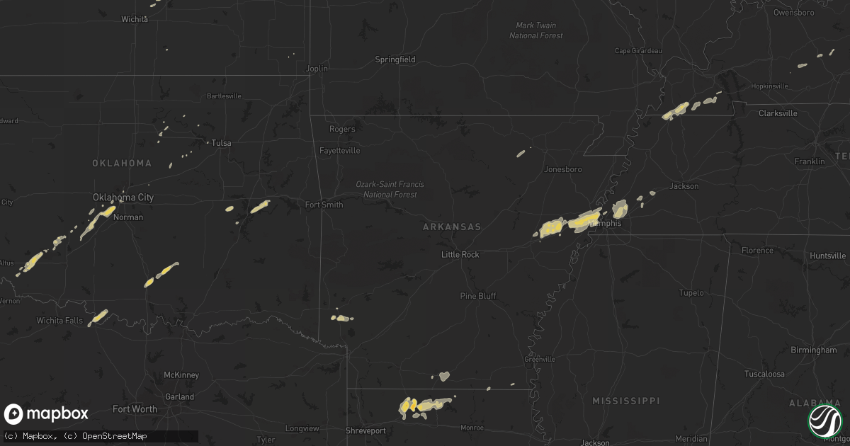
Hail Map on February 24, 2011
Get this storm
February 24 map
$229
one time, instant access
Download today. No call, no setup
Keep the $229
Bought the map and want the full workflow? Apply the entire $229 to a subscription within 7 days. None of it is wasted.
Every map, not just this one
This buys you this map. Subscription and you get every map we run, in the markets you choose from a few cities to whole states to nationwide. Plus real-time alerts the moment a storm fires.
Contact data
Name, contact info, occupancy, even credit band for addresses in the footprint. You go from where it hit to who to call.
Become the source they trust
Unlimited branding weather history reports on demand. You already have the documented answer ready for the property owner, and you are the one who showed up with it.
Property data and RoofTrace estimates
Pull up any address you have got, its value and the exact code rules for that jurisdiction, straight from One Click Code. Then RoofTrace estimates the squares, pitch, and roof value, priced the way you price.
States Impacted by Hail Map on February 24, 2011
Storm reports
Oklahoma
| Date | Description |
|---|---|
| 02/24/201112:17 PM CST | A local report indicates 1.00 inch wind near 1 N PORUM |
Mississippi
| Date | Description |
|---|---|
| 02/23/201111:18 PM CST | A couple trees down...1 across cr 168. |
| 02/23/201111:04 PM CST | A couple trees were blown down. |
| 02/23/201110:17 PM CST | A couple trees were blown down. |
| 02/23/201110:15 PM CST | A tree was blown down on a house in the city of columbus. |
| 02/23/201110:15 PM CST | 8 trees were blown down around the city of caledonia. |
| 02/23/201110:03 PM CST | A couple trees were blown down. |
| 02/23/20119:57 PM CST | Several trees blown down. |
| 02/23/20119:55 PM CST | Trees and powerlines down on jasper street |
| 02/23/20119:53 PM CST | Trees and power lines down all over town. |
| 02/23/20119:52 PM CST | Trees...powerlines and power poles down |
| 02/23/20119:51 PM CST | Limbs and mailboxes blown over...car blown over near beaver lake. |
| 02/23/20119:50 PM CST | Utility lines along old fannin rd were damaged by large tree limbs. Time estimated. |
| 02/23/20119:50 PM CST | Several trees down across belmont |
| 02/23/20119:50 PM CST | Lewisburg and match hatcher trees down |
| 02/23/20119:44 PM CST | A few trees down and a fence blown down. |
| 02/23/20119:38 PM CST | Trees/power lines down in new wren...cason...smithville. 3 mobile homes with some damage. |
| 02/23/20119:35 PM CST | Trees down in northwestern and western leake county |
| 02/23/20119:32 PM CST | Roof peeled back on a business near the intersection of north port road and hwy 76. |
| 02/23/20119:32 PM CST | Several trees down in saltillo...possible tornado. |
| 02/23/20119:30 PM CST | Several trees were blown down. |
| 02/23/20119:30 PM CST | Trees were downed along highway 407...highway 790...and highway 9 across choctaw county. |
| 02/23/20119:25 PM CST | A couple trees were downed...partially blocking dewees rd. Time estimated. |
| 02/23/20119:25 PM CST | Trees down along highway 341 and county road 102. |
| 02/23/20119:25 PM CST | Trees and power lines down countywide. |
| 02/23/20119:25 PM CST | A local report indicates 59 MPH wind near TUPELO |
| 02/23/20119:25 PM CST | Trees...powerlines and power poles down |
| 02/23/20119:20 PM CST | A few trees were downed across attala county. |
| 02/23/20119:15 PM CST | Several large trees down...some on cars around new harmony and blue springs |
| 02/23/20119:10 PM CST | Trees were downed across webster county. One tree fell across highway 9 near walthall...and a car accident resulted. Numerous power outages countywide. |
| 02/23/20119:00 PM CST | Trees and power lines were downed across all of montgomery county |
| 02/23/20118:50 PM CST | Trees were reported down in the city of lexington...including one tree blocking highway 17 n |
| 02/23/20118:40 PM CST | Several trees and power lines downed across yazoo county. Some trees were blocking roadways. Some minor tree fires were reported as a result of damaged utility lines. S |
| 02/23/20118:35 PM CST | Numerous trees down around carrollton...some trees blocking roads |
| 02/23/20118:30 PM CST | Several trees down in multiple locations |
| 02/23/20118:30 PM CST | Recorded at grenada municipal airport |
| 02/23/20118:20 PM CST | Trees were blown down in the northern part of the county. A large tree was downed across a road in money. |
| 02/23/20118:20 PM CST | A large fence was blown down at an industrial park near greenwood |
| 02/23/20118:16 PM CST | Trees down |
| 02/23/20118:15 PM CST | Two homes were damaged in itta bena...one sustained roof damage...and the other sustained window damage. |
| 02/23/20118:15 PM CST | Power outage reported in greenwood. Likely from damaging winds. |
| 02/23/20118:15 PM CST | Trees and power lines were downed along pluck rd |
| 02/23/20118:15 PM CST | Two trees were downed between greenwood and itta bena |
| 02/23/20118:00 PM CST | Trees were downed around nitta yuma |
| 02/23/20117:51 PM CST | Limbs and mailboxes blown over...car blown over near beaver lake. |
| 02/23/20117:50 PM CST | Trees and power lines knocked down |
| 02/23/20117:50 PM CST | Trees and power poles down. |
| 02/23/20117:50 PM CST | Tornado tracked from grace 6.5 miles to 1.5 se nitta yuma in sharkey co. Estimated max winds 115 mph...path length 6.5...max path width 400 yds. Several homes sustained |
| 02/23/20117:50 PM CST | Tree limbs down and tin roofs off some structures |
| 02/23/20117:44 PM CST | Estimated wind gust associated with the dozen downed power poles. |
| 02/23/20117:40 PM CST | Around a dozen power poles were downed by high winds. Several power outages in the area around the state penitentiary. |
| 02/23/20117:38 PM CST | Carport blown off of a mobile home and onto two nearby parked cars |
| 02/23/20117:30 PM CST | Trees downed...some blocking roads...and roofs damaged in the city of cleveland |
| 02/23/20117:30 PM CST | Estimated wind gust associated with the roof dmg to the casino outside greenville. |
| 02/23/20117:27 PM CST | Part of the roof blown off a casino near the mississippi river bridges. Several light poles also blown down in the parking lot. |
Missouri
| Date | Description |
|---|---|
| 02/24/20115:49 PM CST | Tornado reported near portageville. Vehicles blown off interstate 55 from portageville north to marston. |
| 02/24/20115:40 PM CST | Vehicles pushed off road near the intersection of i-55 and hwy a 3 miles east of wardell |
| 02/23/20116:00 PM CST | Peak wind 75 mph. Path width 75 yards and length 300 yards. 2 well constructed barns destroyed. Shingle and/or siding damage to several homes. |
Tennessee
| Date | Description |
|---|---|
| 02/24/20118:29 AM CST | House struck by lightning around 430 am. House located on butt road in north central sumner co. Reported by em mgr. |
| 02/24/20111:50 AM CST | Several trees down along cnty rd 500 |
| 02/24/20111:45 AM CST | Numerous trees down. |
| 02/24/20111:30 AM CST | Numerous trees down. |
| 02/24/20111:30 AM CST | Numerous trees down. |
| 02/24/20111:30 AM CST | Few trees down along route 307. |
| 02/24/20111:30 AM CST | Few trees down. |
| 02/24/20111:15 AM CST | Several trees down and a small carport blown over on conner drive. |
| 02/24/20111:15 AM CST | Several trees down. |
| 02/24/20111:12 AM CST | Five trees and two power lines down in and around knoxville. Reported by dispatch |
| 02/24/20111:00 AM CST | Few trees down. |
| 02/24/20111:00 AM CST | Several trees down. |
| 02/24/201112:45 AM CST | Several trees and numerous power lines down in and around chattanooga. Reported by dispatch. |
| 02/24/201112:42 AM CST | Two trees down in harriman. One tree down in rockwood. One tree down in oliver springs. Reported by dispatch. |
| 02/24/201112:30 AM CST | Few trees down on whitwell mountain. |
| 02/24/201112:30 AM CST | Two trees down and numerous power outages in dayton. Reorted by dispatch. |
| 02/24/201112:15 AM CST | Few trees down. |
| 02/24/201112:08 AM CST | Trees down. Event occurred between 1201am and 1216 am. No location given. |
| 02/24/201112:00 AM CST | Four trees down in and around dunlap. Reported by dispatch. |
| 02/23/201111:35 PM CST | Reported trees down on lewisburg hwy. Damage reported to fayetteville public utilities. |
| 02/23/201111:35 PM CST | Nashville tn wfo conducted a storm survey in pickett county tn and clinton county ky. The survey found that a microburst produced straight line winds of 80 mph and dama |
| 02/23/201111:34 PM CST | Trees down on highway 70 at sand springs just west of monterey |
| 02/23/201111:30 PM CST | Structural damage reported by public. No other details. |
| 02/23/201111:25 PM CST | Trees down on shelbyville hwy. Power outages reported in vann town area. |
| 02/23/201111:00 PM CST | Trees blown over into roads. Rpt from highway dept. |
| 02/23/201110:50 PM CST | A local report indicates 80 MPH wind near SMITHVILLE |
| 02/23/201110:31 PM CST | Tree reported on house near indian lake |
| 02/23/201110:25 PM CST | Trained spotter measured 80mph wind gust with home weather station. |
| 02/23/201110:25 PM CST | Large pine tree down and blocking one lane of shute lane. |
| 02/23/201110:25 PM CST | About 30 homes damaged by fallen trees across davidson county reported by police and fire officials. Hardest hit area is near percy priest lake. |
| 02/23/201110:21 PM CST | Numerous tree down and power outages. Water reported over highway 120. |
| 02/23/201110:14 PM CST | *** 2 inj *** an ef2 tornado occurred in lebanon with a maximum estimated wind speed of 120 mph...with a maximum path width of 150 yards...and a maximum path length of |
| 02/23/201110:06 PM CST | Trees down across jfk drive |
| 02/23/201110:02 PM CST | An ef2 tornado occurred in antioch with a maximum extimated wind speed of 120 mph with a maximum path width of 100 yards and a total path length of 7.5 miles. Damage be |
| 02/23/201110:01 PM CST | Substantial structural damage in the percy priest lake area. Two churches with roofs removed. Some two-story homes with significant damage to their upper story. No inju |
| 02/23/201110:00 PM CST | Public reported tornado near hickory hollow mall area near antioch. |
| 02/23/20119:58 PM CST | Trees down near edmonson and macmurry and near harding |
| 02/23/20119:58 PM CST | Tree down on house on petway avenue in east nashville |
| 02/23/20119:58 PM CST | 4 inch tree down and estimated 65 mph winds |
| 02/23/20119:50 PM CST | Hwy100/yellow creek road...numerous large trees down. |
| 02/23/20119:41 PM CST | Trees down crab creek road. Hwy100...transformer blown off poll. Power outages. |
| 02/23/20119:20 PM CST | Trees and power lines down countywide. |
| 02/23/20119:20 PM CST | Multiple power lines down along lebanon rd. Power outages to area neighborhoods. |
| 02/23/20119:17 PM CST | A local report indicates 65 MPH wind near 7 E CLARKSVILLE |
| 02/23/20119:15 PM CST | Several trees down and other debris along a miles-long stretch of highway 100 |
| 02/23/20119:15 PM CST | Farmers co-op had roof damage. Other minor structure damage included gutters torn off houses. Trees were blown down. |
| 02/23/20119:15 PM CST | Accident i-40...wind related. Mile marker 165. |
| 02/23/20119:15 PM CST | Several large trees down near exit 8 off of i-24 |
| 02/23/20119:15 PM CST | Power outages |
| 02/23/20119:15 PM CST | Several trees down |
| 02/23/20119:15 PM CST | Roof blown off near woodlawn |
| 02/23/20119:10 PM CST | Trees across west crab creek road. Hwy100/spotlight road...transformer blown off pool. Power outages. |
| 02/23/20119:05 PM CST | Ef1 tornado with winds 90 to 100 mph touched down along york road just south of the woodlawn community. Intermittent damage continued 2.3 miles to the northeast. Dozens |
| 02/23/20118:54 PM CST | Very heavy rain |
| 02/23/20118:52 PM CST | Trees down and small limbs on roads |
| 02/23/20118:50 PM CST | Tombstones pulled out of ground in cemetery...7 homes damaged...one mobile home about 75 percent destroyed. Grain bins pulled off concrete pads and numerous farm buildi |
| 02/23/20118:30 PM CST | Tree damage was found along east antioch road and in the russwood shores area near kentucky lake. One tree fell onto a home cuasing substantial damage. Other homes rece |
| 02/23/20118:30 PM CST | Tornado began 2 miles northest of parsons at 830 pm and continued to the cherokee landing area at the tennessee river by 845 pm. Estimated winds were 120 mph...path len |
| 02/23/20118:30 PM CST | 15 houses damaged...with 3 houses having significant damage due to trees falling on them. A mobile home had a roof blown off. This damage was near joy road near kentuck |
| 02/23/20118:23 PM CST | Trees were knocked down on corinth road northwest of darden. A carport was caved in damaging a pickup truck and a shed was destroyed. A tree landed on a house and a roo |
| 02/23/20118:15 PM CST | Trees down just west of henderson near chickasaw...also at sand road to wilson school road. |
| 02/23/20118:15 PM CST | 100 mph wind estimated. |
| 02/23/20118:10 PM CST | Trees down at tate loop road off highway 70 southwest of huntingdon. Power lines were also down. |
| 02/23/20118:10 PM CST | Trees down and small limbs on roads |
| 02/23/20118:07 PM CST | Measured with a weather station |
| 02/23/20118:05 PM CST | Winds at least 80 mph. A large oak tree fell on a carport and portion of a house. Carport is a total loss as well as the car inside. Slight roof and siding damage susta |
| 02/23/20118:05 PM CST | Winds at least 80 mph. A large oak tree fell on a carport and portion of a house. Carport is a total loss as well as the car inside. Slight roof and siding damage susta |
| 02/23/20118:00 PM CST | A local report indicates 60 MPH wind near HENDERSON |
| 02/23/20117:51 PM CST | A local report indicates 64 MPH wind near JACKSON |
| 02/23/20117:50 PM CST | Large tree branches down in yard |
| 02/23/20117:41 PM CST | Winds of 70 mph with small tree limbs down. Penny size hail was also reported. Loose patio furniture along with trash cans blown about. |
| 02/23/20117:41 PM CST | Winds of 70 mph with small tree limbs down. Penny size hail was also reported. Loose patio furniture along with trash cans blown about. |
| 02/23/20117:40 PM CST | Possible tornado near martin. Relayed from martin fire department from a ham radio operator. |
| 02/23/20117:40 PM CST | Powerlines down near old tupperware building on hwy 88 |
| 02/23/20117:40 PM CST | Few trees down |
| 02/23/20117:40 PM CST | Straight line winds destroyed a shed on newcastle drive near armour drive. |
| 02/23/20117:30 PM CST | A few trees and powerlines down across the northern part of fayette county. |
| 02/23/20117:30 PM CST | Trees and power lines down countywide. |
| 02/23/20117:25 PM CST | Trees down on a car near the intersection of mudville road and rosemark road. |
| 02/23/20117:15 PM CST | 100 mph wind estimated. |
| 02/23/20117:15 PM CST | Powerlines down near old tupperware building on hwy 88 |
| 02/23/20117:15 PM CST | Powerlines down...poles have been snapped along highway 209 between the towns of halls and gates. Some structural damage also reported. |
| 02/23/20117:15 PM CST | Powerlines down near the intersection of montgomery and navy. Trees and powerlines also down along navy road near hornet road. Also a tree down on a mobile home in the |
| 02/23/20117:14 PM CST | Large tree down across the road on state route 118 |
| 02/23/20117:13 PM CST | Spotter reported power poles snapped along hwy 209. Also a shop destroyed and a home severely damaged along lawrence road. |
| 02/23/20117:10 PM CST | Few trees down |
| 02/23/20117:10 PM CST | Stoplight damaged at poplar avenue and germantown road. |
| 02/23/20117:05 PM CST | High winds blew off top of chimney near hickory hill |
| 02/23/20117:05 PM CST | 16 foot section of backyard fence blown down. 4x4 fence uprights snapped off at ground level with two 8 foot wide sections of fence airborne for 30 feet. Estimated at 7 |
| 02/23/20117:05 PM CST | Damaging straight line winds moved through east central and northeast lauderdale county. This is the same storm that produced damage across poinsett and mississippi cou |
| 02/23/20117:00 PM CST | Power lines down...street light bent at hwy 64 and hwy 70 |
| 02/23/20116:50 PM CST | Power poles and several trees down in the cornell street and frayser boulevard area. |
| 02/23/20116:39 PM CST | Trees down in the town of glass. |
| 02/23/20116:30 PM CST | Trees down on glass road and south bluff road |
Kentucky
| Date | Description |
|---|---|
| 02/24/201112:55 AM CST | One tree down on brown creek road near 451 and hal rogers parkway at mile marker 56. |
| 02/24/201112:53 AM CST | Estimated 58 mph wind gust in ned. |
| 02/24/201112:10 AM CST | Some small trees were blown down along hwy 92e near monticello. |
| 02/24/201112:10 AM CST | A tree fell on a carport damaging both carport and boat being housed inside the carport. Another tree also fell on a building at another site in keavy and damaged that |
| 02/23/201111:50 PM CST | A screen door was torn from a home along hwy 92e in monticello. A number of power outages were also reported in and around monticello. Multiple trees had been blown dow |
| 02/23/201111:35 PM CST | Nashville tn wfo conducted a storm survey in pickett county tn and clinton county ky. The survey found that a microburst produced straight line winds of 80 mph and dama |
| 02/23/201111:23 PM CST | Extremely heavy rains...sustained high winds with stronger gusts. |
| 02/23/201111:07 PM CST | Trees were downed on highway 33 near the mercer county line. |
| 02/23/201111:00 PM CST | Trees were downed across main roadways in and near columbia. |
| 02/23/201110:58 PM CST | Large trees down on battlefield road in the park. Some of the trees are up to 22 inches in diameter. |
| 02/23/201110:55 PM CST | Tree down blocking state highway 2784 near ky 70 |
| 02/23/201110:20 PM CST | A garage was damaged on littrell road. |
| 02/23/201110:15 PM CST | Trees down in western parts of barren county. |
| 02/23/201110:15 PM CST | Two barns were destroyed near railton. |
| 02/23/201110:10 PM CST | Corrected time on previous lsr. Time was 1110 pm est...not 1010 pm est. Several barns damaged or destroyed...several trees down. Estimated winds of 90 to 100 mph. |
| 02/23/201110:10 PM CST | Tree down across highway 100. |
| 02/23/201110:00 PM CST | Barn roof damage on parkers grove road |
| 02/23/201110:00 PM CST | Cinder block wall of a car wash was blown in. |
| 02/23/201110:00 PM CST | Barn roof damage near charlie ragland road and us 31e |
| 02/23/20119:50 PM CST | Power outages in western williamson county |
| 02/23/20119:42 PM CST | 60 mph gust measured at wky met lab. Sustained 45 mph. |
| 02/23/20119:35 PM CST | A double wide was damaged near oakville. An adult female was trapped inside. The extent of any injuries is unknown at this time. |
| 02/23/20119:17 PM CST | Power outages on the n side of leitchfield for about an hour due to t-storm winds |
| 02/23/20119:10 PM CST | Several barns damaged or destroyed...several trees down. Estimated winds of 90 to 100 mph. |
| 02/23/20119:00 PM CST | Concentrated straight-line wind damage occurred 5 miles west of crofton along the consolation loop and hwy 800. Peak wind 85 mph. Path width 3/4 of a mile and length 2 |
| 02/23/20118:56 PM CST | Butler county department of highways reported trees across al emery road and brooklyn chapel road near brooklyn. |
| 02/23/20118:50 PM CST | A barn and shed were destroyed near the intersection of highway 431 and highway 2371. A double wide sustained some siding damage just south of this. |
| 02/23/20118:50 PM CST | Tree down on highway 431. |
| 02/23/20118:30 PM CST | A local report indicates 62 MPH wind near CENTRAL CITY |
| 02/23/20118:30 PM CST | Late report...winds estimated 60 to 65 mph. |
| 02/23/20118:19 PM CST | 10 power poles snapped and debris and electrical lines lying across princeton road on the northwest side of town. |
| 02/23/20117:55 PM CST | Ef2 tornado touched down 2.5 miles ne of gracey along quinsberry lane...and travelled 5.5 miles to near dawson springs road 3.5 miles nw of hopkinsville. Peak wind 115 |
| 02/23/20117:55 PM CST | Wind measured around the 68/80 bypass on the east side of town. Measured winds 65 mph at lovers lane. |
| 02/23/20117:45 PM CST | Several trees and tree limbs down or broken. Some shingles off several homes on highway 139. |
| 02/23/20117:08 PM CST | Several downed trees with wind gusts 45 to 50 mph. |
| 02/23/20116:51 PM CST | Quarter size hail reported 1 mile south of town. Visibility near zero with very strong winds. |
| 02/23/20116:50 PM CST | Late report...tree down on home in the reidland area along hwy 131/said road. |
| 02/23/20116:49 PM CST | A local report indicates 1.00 inch wind near WINGO |
| 02/23/20116:36 PM CST | Carport blown across lone oak road beside orileys auto. Street lights out at intersection of interstate 24 and highway 62. |
| 02/23/20116:35 PM CST | Late report...ef1 tornado with peak wind 95 mph. Path average path width 100 yards. Path length 7.8 miles with no injuries or fatalities. Initial touchdown 2nw of fulto |
| 02/23/20116:18 PM CST | Peak wind 85 mph. Damage area was 150 yards wide and 75 yards long. 1 grain bin destroyed. A grain bin... Machinery shed...carport...vehicle and house were damaged. Bar |
| 02/23/20116:15 PM CST | Ef0 tornado touched down near intersection of 1099 and 125...and traveled east 1 mile to the high school. Path width 50 yards. Peak wind 80 mph. Some windows blown out |
Arkansas
| Date | Description |
|---|---|
| 02/24/20115:50 PM CST | 30 foot tall tree blown over...top of a pine tree missing...power out near the intersection of state route 78 and us-70 |
| 02/24/20115:50 PM CST | Widespread trees and powerlines downed across union county |
| 02/24/20115:45 PM CST | *** 1 inj *** trees...power lines and power poles were blown down. A few trees were blown down on houses and carports. Many roofs were damaged due to shingles being blo |
| 02/24/20115:35 PM CST | Trees down across highway 82 at the columbia and union county line |
| 02/24/20115:32 PM CST | Power lines down at the carlisle exit of interstate 40. Wind damage may be from a possible tornado. |
| 02/24/20115:20 PM CST | Thunderstorm wind gusts were estimated at 60 to 70 mph near hazen. |
| 02/24/20115:15 PM CST | Trees down across highway 79 south. |
| 02/24/20115:10 PM CST | Power lines were down...with power outages in town. |
| 02/24/20115:04 PM CST | Many houses sustained roof damage. There were numerous trees blown down. Power lines were blown down. A porch was blown off of a church. Windows were blown out of a hou |
| 02/24/20115:04 PM CST | Widespread trees and powerlines down across town. Reports of roof torn off arsenal. Indications are that the damage was caused by an ef1 tornado. The survey is still on |
| 02/24/20114:56 PM CST | Telephone pole snapped on highway 13 near mcrae |
| 02/24/20114:55 PM CST | Damage was found on the northwest side of bearskin lake. There were numerous trees blown down. Large metal building had two doors blown in...with one side of the buildi |
| 02/24/20114:50 PM CST | Numerous trees were reported down. |
| 02/24/20114:47 PM CST | A roof was partially torn off of a house. |
| 02/24/20114:45 PM CST | A tree was reported down on interstate 530 at u.s. Highway 67. |
| 02/24/20114:26 PM CST | Numerous trees down around bauxite. |
| 02/24/20114:05 PM CST | Trees and power lines were downed near the saline county line...or around lonsdale. |
| 02/24/20114:05 PM CST | Trees were blown down near highway 5 and owensville cutoff road. Several trees fell on the arkansas forestry commission building near the intersection. |
| 02/24/20114:00 PM CST | Numerous trees down around bauxite. |
| 02/24/20114:00 PM CST | Trees were reported down in the eastern part of perry county near williams junction. |
| 02/24/20114:00 PM CST | Trees down on highway 9. |
| 02/24/20113:55 PM CST | Numerous trees were blown down. A fence was blown down as well. The report is from the alum fork cooperative observing station. |
| 02/24/20113:55 PM CST | The tornado touched down near lake winona...passing through the ouachita national forest before lifting west of lake maumelle. Numerous trees were blown down along the |
| 02/24/20113:55 PM CST | *** 1 inj *** a couple of large trees were downed...with one tree on a house. A woman was injured at the house. A metal roof was peeled back at a nearby lumber yard. |
| 02/24/20113:50 PM CST | Trees and power lines were reported down around hot springs and also the northern part of the county. |
| 02/24/20113:45 PM CST | Mobile home lost a roof in bismarck. |
| 02/23/20117:55 PM CST | A local report indicates 1.00 inch wind near 2 S LOCKESBURG |
| 02/23/20117:30 PM CST | Trees and power lines were downed in the city |
| 02/23/20117:20 PM CST | Wind gusts of 60-70 mph |
| 02/23/20117:12 PM CST | 3 trees down...cars blown off roads and power outages in wilmot. Power outages also in portland. |
| 02/23/20117:00 PM CST | 2 trees were blown down on power lines in dermott. |
| 02/23/20117:00 PM CST | Road signs were blown down. |
| 02/23/20116:47 PM CST | Measured with a handheld anemometer |
| 02/23/20116:42 PM CST | Possible tornado 2 miles southeast of edmonson. |
| 02/23/20116:40 PM CST | Powerlines down on highway 61 and on highway 140 1 mile south of osceola. |
| 02/23/20116:40 PM CST | Possible tornado sighted near lehi along i-40. |
| 02/23/20116:38 PM CST | Roof torn off a gas station in marion. |
| 02/23/20116:38 PM CST | Power lines down |
| 02/23/20116:36 PM CST | Possible tornado crossed hwy 64...tree limbs and leaves were seen blowing across the road. |
| 02/23/20116:35 PM CST | Trees were downed in and around town...with power outages reported. |
| 02/23/20116:30 PM CST | Damaging straight line winds moved through eastern crittenden and northern shelby county. Tree...power line...and some minor structural damage occurred beginning in cra |
| 02/23/20116:29 PM CST | Tractor trailer blown over on interstate 55 at mile marker 24. |
| 02/23/20116:29 PM CST | Tractor trailer blown over on interstate 55 at mile marker 24. |
| 02/23/20116:25 PM CST | Barn destroyed and gin damaged. Tin scattered over wide area. One tree snapped and another tree uprooted. Well pivots turned over about 5 miles north of west ridge. |
| 02/23/20116:25 PM CST | Powerlines down in etowah. |
| 02/23/20116:20 PM CST | Powerlines and a tree down on a house...people are trapped inside. |
| 02/23/20116:20 PM CST | 18 wheeler blown over on its side on hwy 63 near tulot. |
| 02/23/20116:20 PM CST | Trees and signs were blown down in town. |
| 02/23/20116:18 PM CST | Possible tornado just south of lepanto |
| 02/23/20116:15 PM CST | Power poles down |
| 02/23/20116:13 PM CST | Roof taken off of a building in marked tree |
| 02/23/20116:10 PM CST | Possible tornado on route 214 near trumann. Multiple reports of damage between harrisburg and trumann. |
| 02/23/20116:05 PM CST | Damaging straight line winds moved through eastern poinsett and western mississippi counties and the cities of mccormick...marked tree...lepanto...and west ridge betwee |
| 02/23/20116:00 PM CST | Home with tree branches through the roof |
| 02/23/20116:00 PM CST | Home with tree branches through the roof |
| 02/23/20116:00 PM CST | Home with tree branches through the roof |
North Carolina
| Date | Description |
|---|---|
| 02/24/20112:15 AM CST | One tree down on harshaw rd and several down on us 19 |
Alabama
| Date | Description |
|---|---|
| 02/24/20111:35 AM CST | Trees down on and near highway 49 north. |
| 02/24/20111:31 AM CST | Trees down near county road 7. |
| 02/24/20111:25 AM CST | Several trees down along perryman bridge rd and evans bridge rd between heflin and interstate 20 |
| 02/24/20111:22 AM CST | Tree down across cheaha road |
| 02/24/20111:08 AM CST | A local report indicates 58 MPH wind near ANNISTON |
| 02/24/201112:44 AM CST | Tree and powerline down on hwy 117 near mentone post office. Time estimated from radar. |
| 02/24/201112:40 AM CST | Power outages reported. |
| 02/24/201112:37 AM CST | Tree down blocking county road 70. |
| 02/24/201112:36 AM CST | Several trees down |
| 02/24/201112:30 AM CST | Tree reported down on hwy 68. |
| 02/24/201112:30 AM CST | Tree reported down on house in henager. No structural damage reported. |
| 02/24/201112:28 AM CST | Chain link fence blown over and 14 fence poles bent along industrial road. |
| 02/24/201112:27 AM CST | Trees and powerlines down in and around gadsden. |
| 02/24/201112:27 AM CST | Several trees down along and near county road 22 |
| 02/24/201112:25 AM CST | Large tree down on powerlines along meighan blvd. Winds est at 58 mph. |
| 02/24/201112:25 AM CST | Several trees down along or near moody parkway |
| 02/24/201112:22 AM CST | Power outages reported. |
| 02/24/201112:17 AM CST | Powerlines down on 231 at rattlesnake hill. |
| 02/24/201112:15 AM CST | A railroad arm was broken on oakwood avenue. |
| 02/24/201112:13 AM CST | Trees blown down on rocky hollow road. |
| 02/24/201112:08 AM CST | Widespread trees and powerlines down in and around gallant. |
| 02/24/201112:06 AM CST | Major substation has been taken out in hampton cove. Reports of large and long lived power flash in the area. Large power outage in southeast quadrant of madison county |
| 02/24/201112:05 AM CST | Trees down on storage building at the intersection of queenstown road and 2nd street. |
| 02/24/201112:03 AM CST | Powerlines down in ruth community near arab. |
| 02/23/201111:58 PM CST | Roof blown off barn |
| 02/23/201111:57 PM CST | Power pole knocked down |
| 02/23/201111:56 PM CST | Mutiple power outages reported in hampton cove and owens crossroads. |
| 02/23/201111:55 PM CST | Power outages reported in owens crossroads on hampton road. |
| 02/23/201111:54 PM CST | Tree down across co hwy 1. |
| 02/23/201111:51 PM CST | Tree on house on pinney wood road. |
| 02/23/201111:50 PM CST | Several power poles knocked down. |
| 02/23/201111:50 PM CST | Tree down on residence in arab. |
| 02/23/201111:50 PM CST | Tree down on county road 21. |
| 02/23/201111:47 PM CST | Powerlines down on mount view trail and co hwy 11. |
| 02/23/201111:47 PM CST | Tree down blocking hwy 79 at dallas selfville fire department. |
| 02/23/201111:45 PM CST | Powerlines down along hwy 11 between york and livingston |
| 02/23/201111:45 PM CST | Tree and powerlines down along minor pkwy at the high school. |
| 02/23/201111:45 PM CST | Trees down on forest bend road in brookside. |
| 02/23/201111:45 PM CST | Trees knocked down interrupting power service on coalburg road |
| 02/23/201111:45 PM CST | Trees down. |
| 02/23/201111:43 PM CST | Power lines were knocked down on cr 277. |
| 02/23/201111:41 PM CST | Trees down on thomas loop rd. |
| 02/23/201111:41 PM CST | Tree down along n. Washington street. |
| 02/23/201111:39 PM CST | Tree down on residence on forrest chapel road in oakridge. |
| 02/23/201111:31 PM CST | Trees down at flattop road and mount olive. |
| 02/23/201111:30 PM CST | 61 mph wind gust measured in downtown cullman. |
| 02/23/201111:28 PM CST | Tree blown down on kicker road. Tree blown down on new watermelon road. |
| 02/23/201111:28 PM CST | Winds estimated around 60 mph. |
| 02/23/201111:25 PM CST | Trees were knocked down at the intersection of carters gin road and quarter mountain road. Time estimated by radar. |
| 02/23/201111:25 PM CST | Tree down at the intersection of quarter mountain rd and carters gin rd. Time estimated by radar. |
| 02/23/201111:22 PM CST | Power lines blown down in copeland ferry. |
| 02/23/201111:18 PM CST | Trees down on smith lake dam road near al 69. |
| 02/23/201111:16 PM CST | Up to 15 reports of thunderstorm wind damage were reported throughout cullman county from 1116 pm through approximately 1140 pm. Thunderstorm winds knocked numerous tre |
| 02/23/201111:15 PM CST | Tree down on residence on forrest chapel road in oakridge. |
| 02/23/201111:13 PM CST | Reports of pine and oak trees down...power poles down and skirting torn off a mobile home on garner road. |
| 02/23/201111:13 PM CST | Windows were blown out in a mobile home. |
| 02/23/201111:12 PM CST | Trees down. |
| 02/23/201111:10 PM CST | Trees down in several locations around jasper. |
| 02/23/201111:10 PM CST | An ef-0 tornado with maximum winds of 75 mph and a path width of 20 yards tracked about one quarter mile on a farm just east of battleground. The tornado first snapped |
| 02/23/201111:09 PM CST | Tree down blocking hwy 79 at dallas selfville fire department. |
| 02/23/201111:09 PM CST | Damage to eastside baptist church on highway 118 next to the jasper mall. |
| 02/23/201111:09 PM CST | Trees were blown down near christy lane and gaines road near highway 257 curry highway. |
| 02/23/201111:05 PM CST | Roof off mobile home and trees down on cr 39 at al 278. |
| 02/23/201111:05 PM CST | Trees down. |
| 02/23/201111:04 PM CST | Trees were blown down on scott cemetary road. |
| 02/23/201111:02 PM CST | Barn damaged on duncan road between al 5 and al 195. |
| 02/23/201111:00 PM CST | Trees down blocking road on hwy 18 at the fayette/walker county line. |
| 02/23/201110:59 PM CST | Multiple trees down near hwy 72. |
| 02/23/201110:55 PM CST | Several trees knocked down with 5 inch diameter limbs snapped. |
| 02/23/201110:52 PM CST | Power outage in phil campbell. |
| 02/23/201110:48 PM CST | Trees down. |
| 02/23/201110:37 PM CST | Roof blown off building. |
| 02/23/201110:36 PM CST | Trees down. |
| 02/23/201110:34 PM CST | Barn blown onto highway 107. |
| 02/23/201110:30 PM CST | Trees and power lines down county wide. |
| 02/23/201110:27 PM CST | Media reports 63mph wind gust measured from alfa cam. |
| 02/23/201110:26 PM CST | Trees were knocked down near mile marker 7 on highway 243. |
| 02/23/201110:24 PM CST | Trees and power lines knocked down along highway 13 near the marion county line. |
| 02/23/201110:21 PM CST | Numerous trees and power lines were knocked down along portions of highway 43 between russellville and the county line northeast of hackleburg. |
| 02/23/201110:20 PM CST | Two large trees down along old hackleburg rd. |
| 02/23/201110:20 PM CST | Damage to chicken houses. Tv towers twisted and blown down. Possible tornado. |
| 02/23/201110:20 PM CST | Reports of structural damage along al hwy 253 south of hackleburg. Extent of damage unknown at this time...possible tornado. |
| 02/23/201110:17 PM CST | Power outages in crooked oak and locust shores. |
| 02/23/201110:16 PM CST | Up to 15 reports of thunderstorm wind damage were received within cullman county from 1116 pm through 1140 pm. Numerous trees and powerlines were knocked down. |
| 02/23/201110:15 PM CST | Powerlines down along military street |
| 02/23/201110:13 PM CST | Power outage in oakland. Estimated 60mph wind gust. |
| 02/23/201110:08 PM CST | Roof damage to two homes off cr 19 |
| 02/23/201110:06 PM CST | Damage to residence in downtown cherokee at mm08 on us-72. |
| 02/23/201110:05 PM CST | Trees/power lines down on us-72 near the mississippi/alabama state line. |
Louisiana
| Date | Description |
|---|---|
| 02/24/20115:49 PM CST | A local report indicates 1.50 inch wind near HOMER |
| 02/24/20115:47 PM CST | Numerous trees and powerlines downed |
| 02/24/20115:47 PM CST | Trees downed |
| 02/24/20115:38 PM CST | Trees downed along hwy 154 |
| 02/24/20115:21 PM CST | Gazebo and vehicle damaged...outbuilding with 5 feet of steel rods imbedded underground lifted. |
| 02/24/20115:17 PM CST | Trees downed |
| 02/24/20115:17 PM CST | Trees downed |
| 02/24/20115:17 PM CST | Downed powerline on hwy 164 |
| 02/24/20115:00 PM CST | *** 1 inj *** tree downed on truck in the 200 blk of n curtis...1 injured |
| 02/24/20114:52 PM CST | Tree downed on hwy 157 |
| 02/24/20114:45 PM CST | Tree downed on mobile home in the 1600 block of jefferson paige rd. |
| 02/24/20114:43 PM CST | Trees downed at hwy 3 and lake rd |
| 02/24/20114:30 PM CST | 18 wheeler overturned along hwy 1 |
| 02/23/20117:50 PM CST | Two trees and a power line down along hwy 65 n near shelburn. |
| 02/23/20117:30 PM CST | Trees were downed and a double wide trailor was heavily damaged north of kilbourne. Updated...5 homes were damaged and a church roof was damaged along highway 585...nea |
| 02/23/20117:30 PM CST | Power outages reported in oak grove and kilbourne. Likely from damaging winds. |
| 02/23/20117:25 PM CST | Tornado track was 6 miles with a maximum width of 75 yards from 6 miles wsw of kilbourne to the town of kilbourne. Estimated max winds 95 mph. Tornado overturned a grai |
| 02/23/20117:07 PM CST | Powerlines downed |
| 02/23/20117:03 PM CST | Tree down on new natchitoches road west of monroe resulting in power outages. |
| 02/23/20117:01 PM CST | 60 mph winds plus in the strerlington/perryville area of extreme northern ouachita parish. |
| 02/23/20117:00 PM CST | Several trees downed along bonner ferry rd near bussy lake. Much of the city of bastrop is without power. |
| 02/23/20116:55 PM CST | Trees down near highway 164 and 148. |
| 02/23/20116:55 PM CST | Trees downed in calhoun |
| 02/23/20116:55 PM CST | Trees were downed in the northwestern portion of the parish. |
| 02/23/20116:32 PM CST | Trees down blocking highway 151 |
| 02/23/20116:30 PM CST | Tree downed on hwy 167 in the community of clay |
| 02/23/20116:25 PM CST | Widespread downed trees across the parish |
| 02/23/20116:04 PM CST | Trees downed |
Georgia
| Date | Description |
|---|---|
| 02/24/20112:30 AM CST | One power line down. |
| 02/24/20112:15 AM CST | Heard county 911 relayed a report of a downed tree on south river road in franklin. |
| 02/24/20112:09 AM CST | Pickens county emergency management reported a downed tree in ellijay. |
| 02/24/20112:07 AM CST | Fannin county 911 relayed reports of 2 downed trees. |
| 02/24/20112:02 AM CST | Two trees and two power lines down. |
| 02/24/20112:00 AM CST | One tree down. |
| 02/24/20111:55 AM CST | One tree down on high shoals road. |
| 02/24/20111:41 AM CST | Gilmer county 911 relayed reports of 2 downed trees in ellijay. |
| 02/24/20111:36 AM CST | One tree down. |
| 02/24/20111:30 AM CST | Two trees and two power lines down. |
| 02/24/20111:16 AM CST | Bartow county roads department reported a tree down on the intersection of old alabama and iron hill road. The tree has been cleared and the roadway is open. |
| 02/24/20111:12 AM CST | One tree down. |
| 02/24/20111:00 AM CST | One tree down on shinbone valley road. |
| 02/24/201112:54 AM CST | 3 trees down in the southern end of the county. |
| 02/24/201112:54 AM CST | Three trees and three power lines down in the northwest part of the county. |
| 02/24/201112:40 AM CST | Three trees down in wallwood area of north trenton. |
Cities Impacted by Hail Map on February 24, 2011
- Carnegie, OK
- Springer, OK
- Davis, OK
- Somerville, TN
- Mason, TN
- Terral, OK
- Ryan, OK
- Columbus, KS
- Garnett, KS
- Homer, LA
- Apache, OK
- Forrest City, AR
- Colt, AR
- Proctor, AR
- Memphis, TN
- Turrell, AR
- Widener, AR
- Edmondson, AR
- Marion, AR
- Heth, AR
- Earle, AR
- West Memphis, AR
- Crawfordsville, AR
- Parkin, AR
- Sulphur, OK
- Goodwin, AR
- Palestine, AR
- Wynne, AR
- Lockesburg, AR
- Mineral Springs, AR
- Tipton, OK
- Frederick, OK
- Mcalester, OK
- Indianola, OK
- Dougherty, OK
- Checotah, OK
- Eufaula, OK
- Mountain Park, OK
- Snyder, OK
- Roosevelt, OK
- Union City, TN
- Hickman, KY
- Fulton, KY
- Haynesville, LA
- Horatio, AR
- Anadarko, OK
- Grady, AR
- Star City, AR
- Oklahoma City, OK
- Lisbon, LA
- Dubach, LA
- Morgantown, KY
- Mill Creek, OK
- Roff, OK
- Arlington, TN
- Atoka, TN
- Millington, TN
- Brighton, TN
- Chickasha, OK
- Pocasset, OK
- Verden, OK
- Union City, OK
- Mustang, OK
- Arcadia, LA
- Athens, LA
- Potwin, KS
- El Dorado, KS
- Benton, KS
- Towanda, KS
- Belton, KY
- Dunmor, KY
- Nashville, AR
- Mayfield, KY
- Sedalia, KY
- Wingo, KY
- Minden, LA
- Scammon, KS
- Hardin, KY
- Benton, KY
- Parkdale, AR
- Wilmot, AR
- Ringgold, TX
- Burns, KS
- Burden, KS
- Porum, OK
- Stigler, OK
- Clinton, KY
- Water Valley, KY
- South Fulton, TN
- Amber, OK
- Minco, OK
- Brownsville, TN
- Stanton, TN
- Blanchard, OK
- Cement, OK
- Newcastle, OK
- Tuttle, OK
- Pawnee, OK
- Glencoe, OK
- Stuart, OK
- Drumright, OK
- Frankston, TX
- Spearsville, LA
- Farmerville, LA
- Bernice, LA
- Stillwater, OK
- Fitzhugh, OK
- Wichita, KS
- Mannford, OK
- Munford, TN
- Drummonds, TN
- Jetson, KY
- Strawberry, AR
- Smithville, AR
- Cave City, AR
- Lawton, OK
- El Dorado, AR
- Sand Springs, OK
- Kincaid, KS
- Marion, LA
- Wheatley, AR
- Brinkley, AR
- Cushing, OK
- Anguilla, MS
- Silver City, MS
- Louise, MS
- Hamburg, AR
- Bastrop, LA
- Moro, AR
- Luther, OK
- Kirksey, KY
- Almo, KY
- Farmington, KY
- Murray, KY