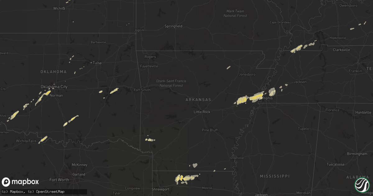
Hail Map in Arkansas on February 24, 2011
Get this storm
February 24 map
$229
one time, instant access
Download today. No call, no setup
Keep the $229
Bought the map and want the full workflow? Apply the entire $229 to a subscription within 7 days. None of it is wasted.
Every map, not just this one
This buys you this map. Subscription and you get every map we run, in the markets you choose from a few cities to whole states to nationwide. Plus real-time alerts the moment a storm fires.
Contact data
Name, contact info, occupancy, even credit band for addresses in the footprint. You go from where it hit to who to call.
Become the source they trust
Unlimited branding weather history reports on demand. You already have the documented answer ready for the property owner, and you are the one who showed up with it.
Property data and RoofTrace estimates
Pull up any address you have got, its value and the exact code rules for that jurisdiction, straight from One Click Code. Then RoofTrace estimates the squares, pitch, and roof value, priced the way you price.
Storm reports in Arkansas
Arkansas
| Date | Description |
|---|---|
| 02/24/20115:50 PM CST | 30 foot tall tree blown over...top of a pine tree missing...power out near the intersection of state route 78 and us-70 |
| 02/24/20115:50 PM CST | Widespread trees and powerlines downed across union county |
| 02/24/20115:45 PM CST | *** 1 inj *** trees...power lines and power poles were blown down. A few trees were blown down on houses and carports. Many roofs were damaged due to shingles being blo |
| 02/24/20115:35 PM CST | Trees down across highway 82 at the columbia and union county line |
| 02/24/20115:32 PM CST | Power lines down at the carlisle exit of interstate 40. Wind damage may be from a possible tornado. |
| 02/24/20115:20 PM CST | Thunderstorm wind gusts were estimated at 60 to 70 mph near hazen. |
| 02/24/20115:15 PM CST | Trees down across highway 79 south. |
| 02/24/20115:10 PM CST | Power lines were down...with power outages in town. |
| 02/24/20115:04 PM CST | Many houses sustained roof damage. There were numerous trees blown down. Power lines were blown down. A porch was blown off of a church. Windows were blown out of a hou |
| 02/24/20115:04 PM CST | Widespread trees and powerlines down across town. Reports of roof torn off arsenal. Indications are that the damage was caused by an ef1 tornado. The survey is still on |
| 02/24/20114:56 PM CST | Telephone pole snapped on highway 13 near mcrae |
| 02/24/20114:55 PM CST | Damage was found on the northwest side of bearskin lake. There were numerous trees blown down. Large metal building had two doors blown in...with one side of the buildi |
| 02/24/20114:50 PM CST | Numerous trees were reported down. |
| 02/24/20114:47 PM CST | A roof was partially torn off of a house. |
| 02/24/20114:45 PM CST | A tree was reported down on interstate 530 at u.s. Highway 67. |
| 02/24/20114:26 PM CST | Numerous trees down around bauxite. |
| 02/24/20114:05 PM CST | Trees were blown down near highway 5 and owensville cutoff road. Several trees fell on the arkansas forestry commission building near the intersection. |
| 02/24/20114:05 PM CST | Trees and power lines were downed near the saline county line...or around lonsdale. |
| 02/24/20114:00 PM CST | Trees were reported down in the eastern part of perry county near williams junction. |
| 02/24/20114:00 PM CST | Trees down on highway 9. |
| 02/24/20114:00 PM CST | Numerous trees down around bauxite. |
| 02/24/20113:55 PM CST | *** 1 inj *** a couple of large trees were downed...with one tree on a house. A woman was injured at the house. A metal roof was peeled back at a nearby lumber yard. |
| 02/24/20113:55 PM CST | The tornado touched down near lake winona...passing through the ouachita national forest before lifting west of lake maumelle. Numerous trees were blown down along the |
| 02/24/20113:55 PM CST | Numerous trees were blown down. A fence was blown down as well. The report is from the alum fork cooperative observing station. |
| 02/24/20113:50 PM CST | Trees and power lines were reported down around hot springs and also the northern part of the county. |
| 02/24/20113:45 PM CST | Mobile home lost a roof in bismarck. |
| 02/23/20117:55 PM CST | A local report indicates 1.00 inch wind near 2 S LOCKESBURG |
| 02/23/20117:30 PM CST | Trees and power lines were downed in the city |
| 02/23/20117:20 PM CST | Wind gusts of 60-70 mph |
| 02/23/20117:12 PM CST | 3 trees down...cars blown off roads and power outages in wilmot. Power outages also in portland. |
| 02/23/20117:00 PM CST | Road signs were blown down. |
| 02/23/20117:00 PM CST | 2 trees were blown down on power lines in dermott. |
| 02/23/20116:47 PM CST | Measured with a handheld anemometer |
| 02/23/20116:42 PM CST | Possible tornado 2 miles southeast of edmonson. |
| 02/23/20116:40 PM CST | Possible tornado sighted near lehi along i-40. |
| 02/23/20116:40 PM CST | Powerlines down on highway 61 and on highway 140 1 mile south of osceola. |
| 02/23/20116:38 PM CST | Power lines down |
| 02/23/20116:38 PM CST | Roof torn off a gas station in marion. |
| 02/23/20116:36 PM CST | Possible tornado crossed hwy 64...tree limbs and leaves were seen blowing across the road. |
| 02/23/20116:35 PM CST | Trees were downed in and around town...with power outages reported. |
| 02/23/20116:30 PM CST | Damaging straight line winds moved through eastern crittenden and northern shelby county. Tree...power line...and some minor structural damage occurred beginning in cra |
| 02/23/20116:29 PM CST | Tractor trailer blown over on interstate 55 at mile marker 24. |
| 02/23/20116:29 PM CST | Tractor trailer blown over on interstate 55 at mile marker 24. |
| 02/23/20116:25 PM CST | Powerlines down in etowah. |
| 02/23/20116:25 PM CST | Barn destroyed and gin damaged. Tin scattered over wide area. One tree snapped and another tree uprooted. Well pivots turned over about 5 miles north of west ridge. |
| 02/23/20116:20 PM CST | 18 wheeler blown over on its side on hwy 63 near tulot. |
| 02/23/20116:20 PM CST | Powerlines and a tree down on a house...people are trapped inside. |
| 02/23/20116:20 PM CST | Trees and signs were blown down in town. |
| 02/23/20116:18 PM CST | Possible tornado just south of lepanto |
| 02/23/20116:15 PM CST | Power poles down |
| 02/23/20116:13 PM CST | Roof taken off of a building in marked tree |
| 02/23/20116:10 PM CST | Possible tornado on route 214 near trumann. Multiple reports of damage between harrisburg and trumann. |
| 02/23/20116:05 PM CST | Damaging straight line winds moved through eastern poinsett and western mississippi counties and the cities of mccormick...marked tree...lepanto...and west ridge betwee |
| 02/23/20116:00 PM CST | Home with tree branches through the roof |
| 02/23/20116:00 PM CST | Home with tree branches through the roof |
| 02/23/20116:00 PM CST | Home with tree branches through the roof |
All States Impacted by Hail Map on February 24, 2011
Cities Impacted by Hail Map on February 24, 2011
- Carnegie, OK
- Springer, OK
- Davis, OK
- Somerville, TN
- Mason, TN
- Terral, OK
- Ryan, OK
- Columbus, KS
- Garnett, KS
- Homer, LA
- Apache, OK
- Forrest City, AR
- Colt, AR
- Proctor, AR
- Memphis, TN
- Turrell, AR
- Widener, AR
- Edmondson, AR
- Marion, AR
- Heth, AR
- Earle, AR
- West Memphis, AR
- Crawfordsville, AR
- Parkin, AR
- Sulphur, OK
- Goodwin, AR
- Palestine, AR
- Wynne, AR
- Lockesburg, AR
- Mineral Springs, AR
- Tipton, OK
- Frederick, OK
- Mcalester, OK
- Indianola, OK
- Dougherty, OK
- Checotah, OK
- Eufaula, OK
- Mountain Park, OK
- Snyder, OK
- Roosevelt, OK
- Union City, TN
- Hickman, KY
- Fulton, KY
- Haynesville, LA
- Horatio, AR
- Anadarko, OK
- Grady, AR
- Star City, AR
- Oklahoma City, OK
- Lisbon, LA
- Dubach, LA
- Morgantown, KY
- Mill Creek, OK
- Roff, OK
- Arlington, TN
- Atoka, TN
- Millington, TN
- Brighton, TN
- Chickasha, OK
- Pocasset, OK
- Verden, OK
- Union City, OK
- Mustang, OK
- Arcadia, LA
- Athens, LA
- Potwin, KS
- El Dorado, KS
- Benton, KS
- Towanda, KS
- Belton, KY
- Dunmor, KY
- Nashville, AR
- Mayfield, KY
- Sedalia, KY
- Wingo, KY
- Minden, LA
- Scammon, KS
- Hardin, KY
- Benton, KY
- Parkdale, AR
- Wilmot, AR
- Ringgold, TX
- Burns, KS
- Burden, KS
- Porum, OK
- Stigler, OK
- Clinton, KY
- Water Valley, KY
- South Fulton, TN
- Amber, OK
- Minco, OK
- Brownsville, TN
- Stanton, TN
- Blanchard, OK
- Cement, OK
- Newcastle, OK
- Tuttle, OK
- Pawnee, OK
- Glencoe, OK
- Stuart, OK
- Drumright, OK
- Frankston, TX
- Spearsville, LA
- Farmerville, LA
- Bernice, LA
- Stillwater, OK
- Fitzhugh, OK
- Wichita, KS
- Mannford, OK
- Munford, TN
- Drummonds, TN
- Jetson, KY
- Strawberry, AR
- Smithville, AR
- Cave City, AR
- Lawton, OK
- El Dorado, AR
- Sand Springs, OK
- Kincaid, KS
- Marion, LA
- Wheatley, AR
- Brinkley, AR
- Cushing, OK
- Anguilla, MS
- Silver City, MS
- Louise, MS
- Hamburg, AR
- Bastrop, LA
- Moro, AR
- Luther, OK
- Kirksey, KY
- Almo, KY
- Farmington, KY
- Murray, KY


