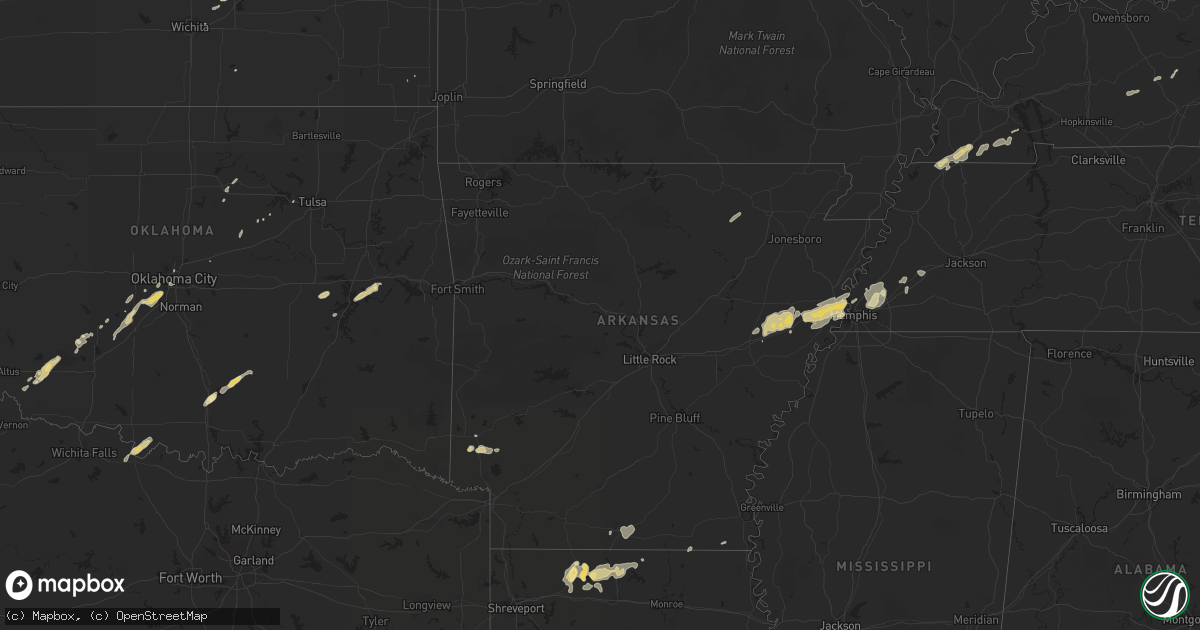
Hail Map in Louisiana on February 24, 2011
Get this storm
February 24 map
$229
one time, instant access
Download today. No call, no setup
Keep the $229
Bought the map and want the full workflow? Apply the entire $229 to a subscription within 7 days. None of it is wasted.
Every map, not just this one
This buys you this map. Subscription and you get every map we run, in the markets you choose from a few cities to whole states to nationwide. Plus real-time alerts the moment a storm fires.
Contact data
Name, contact info, occupancy, even credit band for addresses in the footprint. You go from where it hit to who to call.
Become the source they trust
Unlimited branding weather history reports on demand. You already have the documented answer ready for the property owner, and you are the one who showed up with it.
Property data and RoofTrace estimates
Pull up any address you have got, its value and the exact code rules for that jurisdiction, straight from One Click Code. Then RoofTrace estimates the squares, pitch, and roof value, priced the way you price.
Storm reports in Louisiana
Louisiana
| Date | Description |
|---|---|
| 02/24/20115:49 PM CST | A local report indicates 1.50 inch wind near HOMER |
| 02/24/20115:47 PM CST | Trees downed |
| 02/24/20115:47 PM CST | Numerous trees and powerlines downed |
| 02/24/20115:38 PM CST | Trees downed along hwy 154 |
| 02/24/20115:21 PM CST | Gazebo and vehicle damaged...outbuilding with 5 feet of steel rods imbedded underground lifted. |
| 02/24/20115:17 PM CST | Downed powerline on hwy 164 |
| 02/24/20115:17 PM CST | Trees downed |
| 02/24/20115:17 PM CST | Trees downed |
| 02/24/20115:00 PM CST | *** 1 inj *** tree downed on truck in the 200 blk of n curtis...1 injured |
| 02/24/20114:52 PM CST | Tree downed on hwy 157 |
| 02/24/20114:45 PM CST | Tree downed on mobile home in the 1600 block of jefferson paige rd. |
| 02/24/20114:43 PM CST | Trees downed at hwy 3 and lake rd |
| 02/24/20114:30 PM CST | 18 wheeler overturned along hwy 1 |
| 02/23/20117:50 PM CST | Two trees and a power line down along hwy 65 n near shelburn. |
| 02/23/20117:30 PM CST | Trees were downed and a double wide trailor was heavily damaged north of kilbourne. Updated...5 homes were damaged and a church roof was damaged along highway 585...nea |
| 02/23/20117:30 PM CST | Power outages reported in oak grove and kilbourne. Likely from damaging winds. |
| 02/23/20117:25 PM CST | Tornado track was 6 miles with a maximum width of 75 yards from 6 miles wsw of kilbourne to the town of kilbourne. Estimated max winds 95 mph. Tornado overturned a grai |
| 02/23/20117:07 PM CST | Powerlines downed |
| 02/23/20117:03 PM CST | Tree down on new natchitoches road west of monroe resulting in power outages. |
| 02/23/20117:01 PM CST | 60 mph winds plus in the strerlington/perryville area of extreme northern ouachita parish. |
| 02/23/20117:00 PM CST | Several trees downed along bonner ferry rd near bussy lake. Much of the city of bastrop is without power. |
| 02/23/20116:55 PM CST | Trees downed in calhoun |
| 02/23/20116:55 PM CST | Trees were downed in the northwestern portion of the parish. |
| 02/23/20116:55 PM CST | Trees down near highway 164 and 148. |
| 02/23/20116:32 PM CST | Trees down blocking highway 151 |
| 02/23/20116:30 PM CST | Tree downed on hwy 167 in the community of clay |
| 02/23/20116:25 PM CST | Widespread downed trees across the parish |
| 02/23/20116:04 PM CST | Trees downed |
All States Impacted by Hail Map on February 24, 2011
Cities Impacted by Hail Map on February 24, 2011
- Carnegie, OK
- Springer, OK
- Davis, OK
- Somerville, TN
- Mason, TN
- Terral, OK
- Ryan, OK
- Columbus, KS
- Garnett, KS
- Homer, LA
- Apache, OK
- Forrest City, AR
- Colt, AR
- Proctor, AR
- Memphis, TN
- Turrell, AR
- Widener, AR
- Edmondson, AR
- Marion, AR
- Heth, AR
- Earle, AR
- West Memphis, AR
- Crawfordsville, AR
- Parkin, AR
- Sulphur, OK
- Goodwin, AR
- Palestine, AR
- Wynne, AR
- Lockesburg, AR
- Mineral Springs, AR
- Tipton, OK
- Frederick, OK
- Mcalester, OK
- Indianola, OK
- Dougherty, OK
- Checotah, OK
- Eufaula, OK
- Mountain Park, OK
- Snyder, OK
- Roosevelt, OK
- Union City, TN
- Hickman, KY
- Fulton, KY
- Haynesville, LA
- Horatio, AR
- Anadarko, OK
- Grady, AR
- Star City, AR
- Oklahoma City, OK
- Lisbon, LA
- Dubach, LA
- Morgantown, KY
- Mill Creek, OK
- Roff, OK
- Arlington, TN
- Atoka, TN
- Millington, TN
- Brighton, TN
- Chickasha, OK
- Pocasset, OK
- Verden, OK
- Union City, OK
- Mustang, OK
- Arcadia, LA
- Athens, LA
- Potwin, KS
- El Dorado, KS
- Benton, KS
- Towanda, KS
- Belton, KY
- Dunmor, KY
- Nashville, AR
- Mayfield, KY
- Sedalia, KY
- Wingo, KY
- Minden, LA
- Scammon, KS
- Hardin, KY
- Benton, KY
- Parkdale, AR
- Wilmot, AR
- Ringgold, TX
- Burns, KS
- Burden, KS
- Porum, OK
- Stigler, OK
- Clinton, KY
- Water Valley, KY
- South Fulton, TN
- Amber, OK
- Minco, OK
- Brownsville, TN
- Stanton, TN
- Blanchard, OK
- Cement, OK
- Newcastle, OK
- Tuttle, OK
- Pawnee, OK
- Glencoe, OK
- Stuart, OK
- Drumright, OK
- Frankston, TX
- Spearsville, LA
- Farmerville, LA
- Bernice, LA
- Stillwater, OK
- Fitzhugh, OK
- Wichita, KS
- Mannford, OK
- Munford, TN
- Drummonds, TN
- Jetson, KY
- Strawberry, AR
- Smithville, AR
- Cave City, AR
- Lawton, OK
- El Dorado, AR
- Sand Springs, OK
- Kincaid, KS
- Marion, LA
- Wheatley, AR
- Brinkley, AR
- Cushing, OK
- Anguilla, MS
- Silver City, MS
- Louise, MS
- Hamburg, AR
- Bastrop, LA
- Moro, AR
- Luther, OK
- Kirksey, KY
- Almo, KY
- Farmington, KY
- Murray, KY


